Natural Resources
Conservation Service
Ecological site F149BY005MA
Dry Outwash
Last updated: 5/20/2025
Accessed: 02/07/2026
General information
Provisional. A provisional ecological site description has undergone quality control and quality assurance review. It contains a working state and transition model and enough information to identify the ecological site.

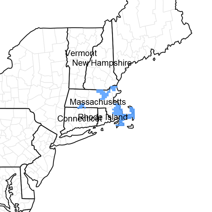
Figure 1. Mapped extent
Areas shown in blue indicate the maximum mapped extent of this ecological site. Other ecological sites likely occur within the highlighted areas. It is also possible for this ecological site to occur outside of highlighted areas if detailed soil survey has not been completed or recently updated.
MLRA notes
Major Land Resource Area (MLRA): 149B–Long Island-Cape Cod Coastal Lowland
149B—Long Island-Cape Cod Coastal Lowland
It is mostly an area of nearly level to rolling plains, but it has some steeper hills (glacial moraines). Ridges border the lower plains. The Peconic and Carmans Rivers are on the eastern end of Long Island. The parts of this area in Massachusetts and Rhode Island have no major rivers. This entire area is made up of deep, unconsolidated glacial outwash deposits of sand and gravel. A thin mantle of glacial till covers some of the surface. Some moraines form ridges and higher hills in this area of generally low relief. Sand dunes and tidal marshes are extensive along the coastline.
Classification relationships
USDA-NRCS (USDA, 2006):
Land Resource Region (LRR): S—Northern Atlantic Slope Diversified Farming Region
Major Land Resource Area (MLRA): 149B—Long Island-Cape Cod Coastal Lowland
USDA-FS (Cleland et al., 2007):
Province: 221 Eastern Broadleaf Forest Province
Section: 221A Lower New England
Subsection: 221Ab Cape Cod Coastal Lowland and Islands
Subsection: 221An Long Island Coastal Lowland and Moraine
Ecological site concept
Pitch pine - oak woodland occurring on very well-drained sandy outwash.
Concept summary from (Sneddon, et al. 2010):
The vegetation is a matrix woodland type of the central Pine Barrens from Long Island, New York, north to Cape Cod, Massachusetts. It occurs on very well-drained sandy outwash or moraine deposits. The canopy is dominated by Pinus rigida (pitch pine) plus the following oaks in variable proportions: Quercus coccinea (scarlet oak), Quercus velutina (black oak), Quercus alba (white oak), and Quercus rubra (northern red oak) and occasionally Quercus stellata (post oak). Tall shrubs such as Quercus ilicifolia (bear oak) can be sporadic to locally well-developed. Heaths tend to form a dense dwarf-shrub layer, especially Gaylussacia baccata (black huckleberry), Vaccinium angustifolium (lowbush blueberry), and Vaccinium pallidum (Blue Ridge blueberry). Morella pensylvanica (northern bayberry) can also commonly occur. The herb layer is often sparse and characterized by Pteridium aquilinum (western brackenfern), Gaultheria procumbens (eastern teaberry), and Carex pensylvanica (Pennsylvania sedge). This mixed conifer-deciduous woodland is a fire-dependent community with a proportion of canopy species dependent on the fire regime.
Associated sites
| F149BY006NY |
Well Drained Outwash Well-drained Outwash |
|---|
Similar sites
| F149BY006NY |
Well Drained Outwash Well-drained Outwash |
|---|
Table 1. Dominant plant species
| Tree |
(1) Pinus rigida |
|---|---|
| Shrub |
(1) Vaccinium angustifolium |
| Herbaceous |
(1) Carex pensylvanica |
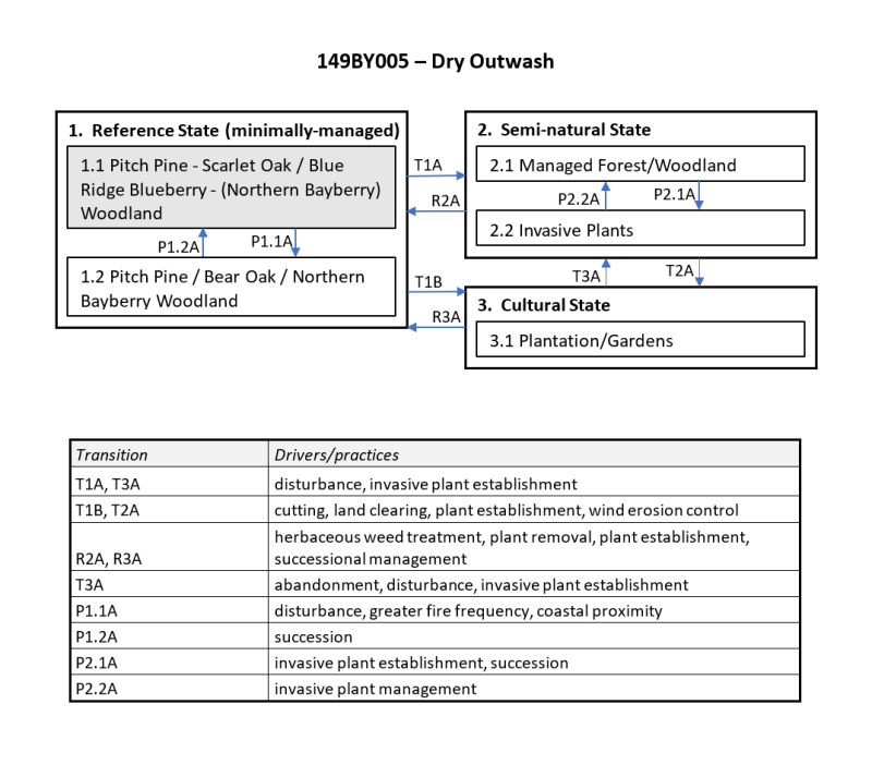
Click on box and path labels to scroll to the respective text.
