Natural Resources
Conservation Service
Ecological site F154XA009FL
Moist Basic Pine Uplands
Last updated: 5/13/2025
Accessed: 02/08/2026
General information
Provisional. A provisional ecological site description has undergone quality control and quality assurance review. It contains a working state and transition model and enough information to identify the ecological site.
MLRA notes
Major Land Resource Area (MLRA): 154X–South-Central Florida Ridge
This MLRA makes up about 7,209 square miles (18,672 square kilometers) and is entirely in Florida. MLRA 154 contains a series of parallel, prominent sandy ridges of Pleistocene marine origin, including the Brooksville and Mount Dora Ridges. These north to south oriented parallel ridges are interspersed with more low lying physiographic provinces, including: upland hills, plains, valleys and gaps (Puri and Vernon 1964).
Many of the soils in this sub-unit are Pleistocene or Holocene sands that are underlain with older, loamy Pliocene marine sediments (Cypresshead formation) or the clayey Miocene marine sediments (Hawthorne formation). A combination of marine depositional events and the dissolution of underlying limestone (karst geology) is responsible for surficial topography throughout Peninsular Florida.
Classification relationships
All portions of the geographical range of this site falls under the following ecological / land classifications including:
-Environmental Protection Agency’s Level 3 and 4 Ecoregions of Florida: 75 Southern Coastal Plain; 75c Central Florida Ridges and Uplands (Griffith, G. E., Omernik, J. M., & Pierson, S. M., 2013)
-Florida Natural Area Inventory, 2010 Edition: Upland Pine, Upland Mixed Woodland, and Upland Hardwood Forest (FNAI, 2010)
Ecological site concept
This site is associated with Pleistocene or Holocene sands which are underlain by older, loamy Pliocene marine sediments (Cypresshead formation) or the clayey Miocene marine sediments (Hawthorne formation). A combination of marine depositional events and the dissolution of underlying limestone (karst geology) is responsible for surficial topography throughout Peninsular Florida. Soils are moderately well to well drained and have loamy subsoil with high base saturation. Limestone bedrock is within 80 inches on some soils. The map unit components occur on low gradient slopes of less than 5%.
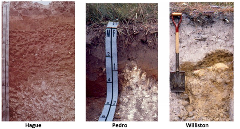
This concept includes shallow to moderately deep, fertile, well drained map units (i.e., Hague, Levyville, Jonesville, Pedro, Shadeville, and Williston series). This site is extensive in the Fairfield Hills, Ocala Hill, Sumter Upland, and Western Valley physiographic units.
Associated sites
| R154XX001FL |
Yellow Sands Xeric Uplands This site is found on excessively well drained soils on slightly higher, drier, xeric landforms |
|---|---|
| F154XX002FL |
Xeric Bicolor Sandy Uplands This site is found on excessively well drained soils on slightly higher, drier, xeric landforms |
| F154XA003FL |
Dry Yellow Sands Pine Woodland This site is found on excessively well drained soils on slightly higher, drier, xeric landforms |
| F154XA004FL |
Moist Sandy Pine-Hardwood Woodlands This site is found on somewhat poorly to moderately well drained soils on slightly lower landforms |
| F154XA006FL |
Dry White Sand Scrubs This site is found on well drained soils on similar landforms |
| F154XA008FL |
Moist Sandy Scrubby Flatwoods This site is found on somewhat poorly to moderately well drained soils on slightly lower landforms |
Similar sites
| F154XA006FL |
Dry White Sand Scrubs This site is well drained on similar landform positions but will have lower subsoil silt and clay percentages (less than 10 %) that will reflect differences in the types and amount of vegetation present. |
|---|
Table 1. Dominant plant species
| Tree |
(1) Pinus palustris |
|---|---|
| Shrub |
(1) Quercus falcata |
| Herbaceous |
(1) Aristida stricta |
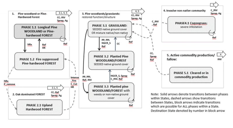
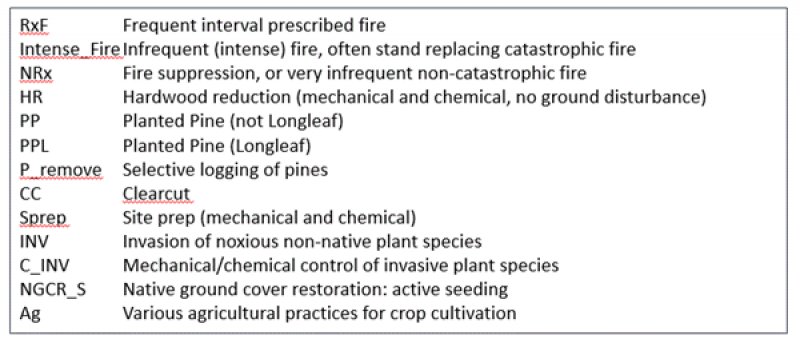
Click on box and path labels to scroll to the respective text.


