
Natural Resources
Conservation Service
Ecological site VX158X01X004
Rocky Isohyperthermic Torric Naturalized Grassland Kiawe/uhaloa/buffelgrass (Prosopis pallida/Waltheria indica/Pennisetum ciliare)
Last updated: 4/17/2025
Accessed: 02/27/2026
General information
Provisional. A provisional ecological site description has undergone quality control and quality assurance review. It contains a working state and transition model and enough information to identify the ecological site.
MLRA notes
Major Land Resource Area (MLRA): 158X–Semiarid and Subhumid Low Mountain Slopes
MLRA 158 – Semiarid and Subhumid Low Mountain Slopes
This MLRA occurs in the State of Hawaii on the islands of Hawaii, Maui, Lanai, Molokai, Oahu, and Kauai. It consists primarily of nearly level to moderately steep slopes that are dissected in places by gulches. It occurs on leeward, drier sides of the older volcanoes within the Hawaiian Islands. Elevation ranges from sea level to 1600 feet (0 to 490 meters). Geology is largely highly weathered volcanic ash overlying basic igneous rocks. Alluvium derived from basic igneous rocks occurs in some areas. Average annual precipitation typically ranges from 10 to 30 inches (255 to 760 millimeters), rising to over 60 inches (1525 millimeters) in some areas, and mostly occurs from November through March. Much of the rainfall occurs in kona storms during winter. Average annual temperatures range from 69 to 76 degrees F (21 to 24 degrees C), with very little seasonal variation. Soils are mostly Oxisols, Mollisols, and Aridisols with isohyperthermic soil temperature regime and ustic or aridic (torric) soil moisture regimes. Native vegetation is rare and consists of species characteristic of dry habitats, such as wiliwili, ohe makai, ilima and uhaloa. Naturalized grasses, such as buffelgrass and guineagrass, and trees, such as koa haole and kiawe, are common.
Classification relationships
This ecological site occurs within Major Land Resource Area (MLRA) 158 - Arid and Semiarid Low Mountain Slopes.
Ecological site concept
This ecological site occurs on the leeward sides of the islands of Maui, Molokai, Oahu, and Kauai. Most of the area is owned by the State of Hawaii and Division of Hawaiian Homelands, but parts are on large, private ranches and other private holdings.
The central concept of the Rocky Isohyperthermic Torric Naturalized Grassland is of well drained, moderately deep to deep Oxisols and Mollisols formed in alluvium or residuum. Stoniness or other soil factors that reduce the plant available water holding capacity of the soils, combined with low annual rainfall (mostly 10 to 20 inches or 25 to 50 millimeters), result in low vegetation production. Soil temperatures are very warm (isohyperthermic); soil moisture conditions (aridic/torric) are dry most of the year. Elevations range from sea level (0 meters) to about 1800 feet (550 meters). Because very little of the original native vegetation remains, the reference state of this ecological site consists of the dominant naturalized grassland vegetation. The dominant grass species is buffelgrass (Cenchrus ciliaris). Common naturalized trees are kiawe (Prosopis pallida) and koa haole (Leucaena leucocephala). The original native vegetation was dry savanna or shrubland. Common native species, based on the current environment and remnant occurrences, likely included alahee (Psydrax odorata), ohe makai (Polyscias sandwicensis syn. Reynoldsia sandwicensis), wiliwili (Erythrina sandwicensis), naio (Myoporum sandwicense), koaia (Acacia koaia), aalii (Dodonaea viscosa), ilima (Sida fallax), huehue (Cocculus orbiculatus), and native grasses.
Associated sites
| VX163X01X001 |
Shrink-Swell Clay The Clayey Alluvial Plain co-occurs with the Rocky Isohyperthermic Torric Naturalized Grassland on the islands of Kauai, Oahu, and Molokai, where it occurs on alluvial flats that receive alluvium from the Rocky Isohyperthermic Torric Naturalized Grassland. It has the same soil temperature regime, same soil moisture regime, greater annual average rainfall (15 to 35 versus 10 to 20 inches), rises to lower elevations (0 to 500 versus 0 to 1800 feet), and has the same dominant forage grass species compared to the Rocky Isohyperthermic Torric Naturalized Grassland. The Clayey Alluvial Plain consists mostly of Vertisols, which do not occur in the Rocky Isohyperthermic Torric Naturalized Grassland. |
|---|---|
| VX157X01X003 |
Rocky Volcanic Ash Savanna The Rocky Volcanic Ash Savanna occurs on the islands of Hawaii and Maui. It abuts part of the Rocky Isohyperthermic Torric Naturalized Grassland on central Maui. It receives similar average annual rainfall and occurs within a similar elevation range as the Rocky Isohyperthermic Torric Naturalized Grassland. However, the two ecological sites occur in different Major Land Resource Areas. |
| VX157X01X008 |
Rocky Isothermic Naturalized Grassland The Rocky Isothermic Naturalized Grassland occurs only on the island of Maui. It forms the upper-elevation boundary of most of the Rocky Isohyperthermiic Torric Naturalized Grassland. It has a cooler soil temperature regime (isothermic), moister soil moisture regime (mostly ustic versus torric), greater average annual rainfall (15 to 40 versus 10 to 20 inches), occupies higher elevations (1000 to 2600 versus 0 to 1800 feet), supports native dry forest rather than savanna and shrubland, and has a different dominant forage grass species (guineagrass versus buffelgrass) compared to the Rocky Isohyperthermic Torric Naturalized Grassland. |
| VX158X01X002 |
Isohyperthermic Torric Naturalized Grassland Kiawe/buffelgrass (Prosopis pallida/Pennisetum ciliare) The Isohyperthermic Torric Naturalized Grassland co-occurs with the Rocky Isohyperthermic Torric Naturalized Grassland on the islands of Maui, Molokai, Kauai, and, to a very small extent, Oahu. It has the same soil temperature regime, same soil moisture regime (torric versus ustic), greater average annual rainfall (10 to 30 versus 10 to 20 inches), similar elevation range, and the same dominant forage grass species compared to the Rocky Isohyperthermic Torric Naturalized Grassland. The soils in the Isohyperthermic Torric Naturalized Grassland lack the high rock volumes and other water-limiting factors found in the Rocky Isohyperthermic Naturalized Grassland. |
Similar sites
| VX161A01X001 |
Isohyperthermic Desert The Isohyperthermic Desert occurs only on the island of Hawaii. These two ecological sites share soil temperature regimes (although the Isohyperthermic Desert has notably higher soil temperatures) and soil moisture regimes. The Isohyperthermic Desert receives similar average annual rainfall (7 to 20 versus 10 to 20 inches) and a similar elevation range with the Rocky Isohyperthermic Torric Naturalized Grassland, and both ecological site share the same dominant forage grass species. |
|---|---|
| VX166X01X001 |
Isohyperthermic Torric Naturalized Grassland The Isothermic Torric Naturalized Grassland is on the islands of Oahu, Molokai, and Lanai. It has the same soil temperature regime (isohyperthermic), same soil moisture regime (torric), similar average annual rainfall, lower elevation range (0 to 400 feet versus 0 to 1800 feet), and shares the same potential dominant forage grass species. The soils in the Isohyperthermic Torric Naturalized Grassland are not rocky or contain significant factors that reduced soil water holding capacity. |
Table 1. Dominant plant species
| Tree |
(1) Prosopis pallida |
|---|---|
| Shrub |
(1) Waltheria indica |
| Herbaceous |
(1) Pennisetum ciliare |
Legacy ID
R158XY004HI
Physiographic features
This ecological site occurs on basic igneous rock deposited as lava flows on sloping mountainsides of shield volcanoes.
Table 2. Representative physiographic features
| Landforms |
(1)
Shield volcano
> Mountain slope
|
|---|---|
| Runoff class | Low to medium |
| Flooding frequency | None |
| Ponding frequency | None |
| Elevation | 1,800 ft |
| Slope | 25% |
| Water table depth | 60 in |
| Aspect | W, N, S, SW |
Climatic features
(Unless otherwise cited, the information in this section is derived from Western Regional Climate Center, cited 2020).
General principles
Air temperature in the Hawaiian Islands is buffered by the surrounding ocean so that the range in temperature through the year is narrow. This creates “iso-“ soil temperature regimes in which mean summer and winter temperatures differ by less than 6 degrees C (11 degrees F).
The islands lie within the trade wind zone. Significant amounts of moisture are picked up from the ocean by trade winds up to an altitude of more than about 6000 feet (1850 meters). As the trade winds from the northeast are forced up the mountains of the islands their moisture condenses, creating rain on the windward slopes; the leeward sides of the island receive less of this moisture, depending on the height of the mountains.
Hawaiian indigenous understanding recognized two seasons: Kau or Kauwela (dry season) when the sun was directly overhead, days are long and warm and tradewinds are stronger and more consistent; Kau started on the first new moon in May when the Pleiades set at
sunrise (Handy, 1991). During Ho’oilo (wet season) the sun is declined toward the south, days are shorter, temperatures cooler and winds more variable and generally started with the first new moon in November. Ho’oilo is also the season when extensive low-pressure systems often approach the islands from the west, producing heavy rainstorms that primarily affect the leeward sides, but can envelope the entire island. (Malo, 1903, Handy 1991, Sanderson, 1993). These seasons are mostly consistent with modern observations today. These phenomena of pressure systems and seasonal differences interact with the islands’ topography which together creates the various climate zones and patterns observed in the islands. One such general pattern can be seen in the differences in rainfall amounts between winter and summer; in low elevation dry areas the differences are greater whereas wetter areas exhibit less seasonal variation in rainfall.
Summary for this ecological site
Average annual precipitation in this ecological site ranges from 10 to 20 inches (250 to 500 mm). Extremes of average annual precipitation may range as high as 40 inches (1000 mm). In these extreme high rainfall areas, the ecological site probably grades into another ecological site. Most of the precipitation occurs from October through April. Average annual temperatures range from 72 to 75 degrees F (22 to 24 degrees C). Conditions typically are dry. Rainfall occurs as light trade wind showers that drift over or around the mountains from the windward side of the islands and as heavier rainfall during major winter storms. Major storms are important for soil moisture recharge, and the number of major storms is highly variable; drought can result from a winter with few or no storms. Due to the latitude, daylength varies little during the year, resulting in only about a 50 percent variation in solar energy input between June maximum to December minimum; this variation is somewhat less than that found in the continental United States. Conditions are generally clear to lightly cloudy. The Hoolehua plains on the windward side of west Molokai are subject to severe wind erosion by trade winds funneled between the highlands of east and west Molokai.
Table 3. Representative climatic features
| Frost-free period (characteristic range) | 365 days |
|---|---|
| Freeze-free period (characteristic range) | 365 days |
| Precipitation total (characteristic range) | 10-20 in |
Influencing water features
Mostly ephemeral streams flow through small gulches during periods of heavy rainfall. These gulches are associated with the areas of alluvial soils occurring in this ecological site. The narrow zones through which water typically flows are often associated with higher kiawe density than surrounding areas. Broader alluvial zones sometimes have higher kiawe density throughout, but typically in these broader zones the higher kiawe density occurs only in the narrow areas in streambeds and down at the shoreline.
Soil features
The soils in this ecological site are mostly Oxisols and Mollisols, along with two Aridisols, one Inceptisol with oxic properties, and one Andisol formed in alluvium, residuum, volcanic ash, or a combination of parent materials. Soil depths vary among the series. The unifying factors that groups them into this ecological site are low annual rainfall amounts and soil characteristics that limit the plant available water holding capacity.
Soil temperature regimes are isohypothermic (very warm). Soil moisture regimes are torric (in normal years, dry for more than half of the growing season and moist for less than 90 consecutive days during the growing season) or, in Waiakoa and Waiawa soils, moister than torric, being intergrades between ustic and aridic (aridic is similar to torric). Wainee soils are classified as ustic (not as dry as torric or aridic) but have factors (discussed below) that limit soil moisture. All the soils are well drained except Alae series, which are excessively drained.
Surface horizons have pH ranging from 5.8 to 7.5 except for Pakala series, which has a natural pH of 5.0. Extreme pH in subsurface horizons within 30 inches (75 centimeters) of the surface range from 6.4 to 8.2 (5.8 in Pakala series). The Five Islands Soil Survey shows surface horizons of some soil series as having unusually low pH compared to subsurface horizons; these series include Holomua (pH 5.6) and Hoolehua (pH 3.9). The pHs of these two soil series were measured in fields cultivated for pineapple, which was common when the survey was performed (late 1960s to early 1970s); pHs of other soils that were measured under sugarcane or pasture do not exhibit such intense acidity. This phenomenon has been studied in locations around the world and is due to factors involved in pineapple cultivation. The Five Islands survey indicates that Hoolehua soils under pasture had surface pH of 5.8; Holomua soils under pasture would likely be higher than pH 6. It is possible that surface pH has reverted to normal in the decades since pineapple cultivation ended. If planning to establish crops, forage, or trees on these soils or in areas that had been cultivated for pineapple, a pH test is advisable.
HOLOMUA and HOOLEHUA soils are classified as Oxisols. PAKALA soils are Inceptisols with oxic properties. Oxisols are more highly weathered than other soils. These two soils have a deep subsurface oxic horizon dominated by clay-size particles of iron and aluminum hydrous oxides and kaolinite clay. Plant nutrients have been largely leached out of the soil. At low pH, phosphorus is adsorbed onto the oxides, making it largely unavailable to plants, and the ability to retain cation nutrients such as calcium, magnesium, and potassium against leaching is low. However, these two Oxisols have subsurface soils with near neutral or neutral pH, which would counteract the more extreme problems of phosphorus fixation and low nutrient cation retention otherwise found in Oxisols. Also, these two soil series are classified as Eutrotorrox. “Eutro-“ indicates higher (>35%) base saturation and higher fertility than typical Oxisols. Much of the soluble silica, which is an important element for grass tissue stability, has been leached out of the soil. Cementation of clay-sized minerals by iron oxides create a stable, well drained, workable soil, but the cemented, sand-like (pseudosand) particles often create droughty conditions as well. Maintenance of soil organic matter will help to counteract this characteristic.
Hoolehua occur in depressions and drainageways. They naturally have an umbric (thick, dark, high in organic matter, low base saturation, good water holding capacity) surface horizon that is like a low fertility mollic horizon (see below). However, they occur in the dry, windswept northwestern part of Molokai, where they are susceptible to soil erosion and deposition by wind. Rehabilitation of soils here, once eroded, is difficult.
Soils of the PULEHU, WAHIKULI, WAIAKOA, and WAINEE series are classified as Mollisolls. Important properties of Mollisols are a relatively thick, dark surface horizon (mollic epipedon) that does not become hard when dry, a dominance of calcium among the extractable cations, and a dominance of crystalline clay minerals of moderate or high cation-exchange capacity. Although Mollisols usually form under grass in seasonally dry climates, they can form under a forest ecosystem.
Waiakoa soils are very stony to extremely stony, moderately deep (typically 33 inches or 82 centimeters), and well drained, and have an isohyperthermic soil temperature regime and an aridic/ustic intergrade soil moisture regime. Slopes range from 3 to 25 percent, and runoff is slow to medium. Surface and subsurface pH is neutral. Their subsurface has undergone intense weathering in the past that created an oxic horizon (see above) with kaolinitic clay and iron and aluminum oxyhydroxides. Their neutral pH largely counteracts the possible negative effects of those soil minerals.
Wainee soils are very stony to extremely stony, deep (typically 56 inches or 140 centimeters), and well drained. They have an isohyperthermic soil temperature regime and an ustic soil moisture regime. Their mollic horizon on the surface is pachic, meaning it is thicker than typical, being 20 inches (50 centimeters) or more thick. This horizon is fertile and has good water holding capacity. However, annual rainfall is low (generally 10 to 20 inches or 25 to 50 centimeters).
KEAHUA and WAIAWA soils are Aridisols, which are soils with a light-colored surface horizon that has low organic matter content. They are moist for only short periods during the year. The soil moisture regime is an intergrade between aridic and ustic, so is not as dry as most other Aridisols. These clay soils are extremely rocky, which reduces their potential water holding capacity. Soils are very shallow (14 inches or 35 centimeters) and have a lithic contact, which in this case is soil, continuous rock that has few cracks that can be penetrated by roots. Annual rainfall is 20 to 40 inches (50 to 100 centimeters), which is high for this ecological site, but slopes are 30 to 80 percent and runoff is very rapid.
ALAE soils are classified as Andisols. They developed on basaltic volcanic ash and alluvium derived from basaltic rock. Andisols have these general management characteristics: ion exchange capacity that varies with pH, but mostly retaining anions such as nitrate; high phosphorus adsorption, which restricts phosphorus availability to plants; excellent physical properties (low bulk density, good friability, weak stickiness, stable soil aggregates) for cultivation, seedling emergence, and plant root growth; resistance to compaction and an ability to recover from compaction following repeated cycles of wetting and drying; and high capacity to hold water that is available to plants. These characteristics are due to the properties of the parent material, the clay-size noncrystalline materials formed by weathering, and the soil organic matter accumulated during soil formation (Shoji et al. 1993). Alae soils are medial, which means their water holding capacity is relatively low compared to other Andisols. They are vitric, meaning they are relatively coarse in texture and have a high content of unweathered volcanic glass. This gives them the characteristics of lower phosphorus retention, lower contents of aluminum and iron, much lower water holding ability than other Andisols, low bulk density, some remaining plant nutrients in easily weatherable materials, and some cation holding capacity in the pH range (6.8 to 8.2) found in this soil series.
Adjoining the soils described above are areas mapped as MISCELLANEOUS AREAS. By definition, they have little or no soil and support little or no vegetation. In the Five Islands Soil Survey upon which this ecological site is based, Miscellaneous Areas are extensive, and most were mapped by low-intensity reconnaissance methods that provide less-detailed information than that presented for soil series and their phases. In many cases, however, Miscellaneous Areas in Maui, Molokai, Lanai, Oahu, and Kauai are moderately- to well-vegetated and/or contain plant and animal species of interest to conservationists. They are either extremely difficult to access or were not considered important enough at the time of this survey to warrant full expenditure of resources. They are described in the following paragraphs.
BADLAND (BL) adjoins this ecological site on Kauai. It consists of soft or hard saprolite. Runoff is very rapid. These sites are nearly devoid of vegetation; they support ironwood (Casuarina spp.).
ROCK LAND (rRK) occurs on parent materials of basalt or andesite. Rock cover on the surface ranges from 25 to 90 percent; soils are very shallow (less than 10 inches or 25 centimeters). Near this ecological site it occurs mostly in gulches created by ephemeral streams. Vegetation is generally sparse, but in some spots, vegetation is dense due to localized accumulations of soil and extra moisture from seasonal stream flows. Common plant species are kiawe (Prosopis pallida), klu (Vachellia farnesiana), pili grass (Heteropogon contortus), uhaloa (Waltheria indica), and koa haole (Leucaena leucocephala).
ROCK OUTCROP (rRO) has exposed bedrock covering more than ninety percent of the surface. Small areas of lithified coral sand occur on Kauai, Oahu, Lanai, and Molokai. Gulches on Kauai support sparse vegetation on steep sides and denser vegetation in gulch bottoms. Gulch sides on Maui, Molokai, and Lanai are sparsely vegetated; bottoms can be sparse or moderately vegetated.
ROUGH BROKEN LAND (rRR) occurs on very steep sides of gulches and mountainsides. Soil amounts and characteristics are variable; beneath the soil is soft weathered rock. Most occurrences in the vicinity of this ecological site appear to support substantial vegetation cover. Common plant species are common guava (Psidium guajava), Natal redtop (Melinis repens), bermudagrass (Cynodon dactylon), koa haole (Leucaena leucocephala), and molassesgrass (Melinis minutiflora). Active soil erosion is common.
ROUGH BROKEN AND STONY LAND (rRS) occurs on Maui in very steep, stony gulches. Some soil is present in variable amounts. It generally supports shrubs, small trees, and grass with a significant amount of bare ground.
RUBBLE LAND (rRU) is found on western Kauai at the base of very steep slopes. Ninety percent of the surface is covered by stones or boulders. It typically is well vegetated by koa haole.
STONY ALLUVIAL LAND (rSM) consists of stones, boulders, and soil deposited by streams along bottoms of gulches and on alluvial fans. Much of it appears to be well vegetated, especially in gulch bottoms, although the driest gulch bottoms are sparsely vegetated. Common species are kiawe (Prosopis pallida), sweet acacia or klu (Acacia farnesiana), ilima (Sida cordifolia), pili (Heteropogon contortus), and lantana (Lantana camara).
VERY STONY LAND (rVS) occurs near this ecological site on Maui and Molokai. On Maui, parent materials are aa lava with volcanic ash. On Molokai, it consists of stones and boulders over soft weathered bedrock; in a few places there is shallow clayey soil among the stones and boulders. On both islands, 50 to 90 percent of the surface is covered with stones and boulders. Some occurrences of Very Stony Land adjoining this ecological site support vegetation as dense as, or denser than, some of the soil series. The array of plant species is probably similar to that found on soil series.
VERY STONY LAND, ERODED (rVT2) occurs near this ecological site on Molokai. Fifty to 75 percent of the surface is covered with stones and boulders. It is common in shallow gullies and a few deep gullies. Soil material is similar to Holomua, Molokai, Pamoa, and Waikapu series. Slopes are 3 to 40 percent. It contains more soil material than Very Stony Land (rVS) and appears to support more vegetation than Very Stony Land. Soils are clayey and shallower than 24 inches (60 centimeters) but is deeper in low areas where soil can accumulate. It is mostly vegetated but has some bare spots and areas; common species are kiawe, ilima, pili, fingergrass (Chloris barbata).
Table 4. Representative soil features
| Parent material |
(1)
Alluvium
–
volcanic rock
(2) Residuum – volcanic rock |
|---|---|
| Surface texture |
(1) Cobbly loamy sand (2) Stony, very stony, extremely stony silty clay loam (3) Silt loam (4) Stony, very stony, extremely stony silty clay (5) Stony, very stony, extremely stony silty clayVery stony, extremely stony silty clay loam |
| Drainage class | Well drained |
| Permeability class | Moderately slow to moderately rapid |
| Soil depth | 33 – 66 in |
| Surface fragment cover <=3" | Not specified |
| Surface fragment cover >3" | 15% |
| Available water capacity (33-66in) |
2.5 – 5.7 in |
| Soil reaction (1:1 water) (33-66in) |
5.8 – 7.5 |
| Subsurface fragment volume <=3" (Depth not specified) |
Not specified |
| Subsurface fragment volume >3" (Depth not specified) |
Not specified |
Table 5. Representative soil features (actual values)
| Drainage class | Well drained to excessively drained |
|---|---|
| Permeability class | Not specified |
| Soil depth | 14 – 66 in |
| Surface fragment cover <=3" | Not specified |
| Surface fragment cover >3" | Not specified |
| Available water capacity (33-66in) |
Not specified |
| Soil reaction (1:1 water) (33-66in) |
5 – 7.5 |
| Subsurface fragment volume <=3" (Depth not specified) |
Not specified |
| Subsurface fragment volume >3" (Depth not specified) |
Not specified |
Ecological dynamics
The information in this ecological site description (ESD), including the state-and-transition model (STM), was developed using archaeological and historical data, professional experience, and scientific studies. The information is representative of a complex set of plant communities. Not all scenarios or plants are included. Key indicator plants, animals, and ecological processes are described to inform land management decisions.
Natural Disturbances
There have been no lava flows or heavy volcanic ash flows on this ecological site that are recent enough to have affected the current vegetation. Heavy rainfall can cause soil erosion and strong flows in gulches. Major storm events have also been known to trigger significant mud slides and flooding events. (Stearns 1942). Large earthquakes, such as the quake in 1938 may also cause geomorphically significant change to landscapes, although these are rare and impossible to predict. Wildfires prior to human settlement was probably infrequent. Lightning usually occurs in the wetter months and mostly at high elevations and moist windward slopes, and lava flows are intermittent and localized (Abrahamson 2013).
Human Disturbances
Human-related disturbances have been more important than natural disturbances in this ecological site since the arrival of Polynesians and, later, Europeans. This is reflected in the State and Transition Model Diagram.
The first humans are believed to have migrated to Hawaii between 1000 and 1260 AD (Allen, 2014, Wilmhurst, 2011). Subsequent migrations and population growth increased so that by 1600 AD at least 80% of all the lands in Hawaii below about 1500 feet (roughly 500meters) in elevation had been extensively altered by humans (Kirch 1982); some pollen core data suggest that up to 100% of lowlands may have been altered (Athens 1997). By the time of European contact late in the 18th century, the Polynesians had developed high population densities and placed large areas under intensive agriculture (Cuddihy and Stone 1990). While much of this ecological site was probably too dry for agriculture, an extensive pre-colonial agricultural and water system once existed above Lahaina (Pers coms to Kaipo Kekona). Other areas in this ecological were possibly burned to favor the growth of pili grass (Heteropogon contortus) used for thatching.
Prehistoric native lowland forest disturbance can be attributed to clearing for agriculture by hand or by fire, introduction of new plants, animals, possibly plant diseases, and wood harvesting. The introduced Pacific rat would have eaten bird eggs, invertebrates, and the seeds of native plants (Athens 1997).
After the arrival of Europeans, documentary evidence attests to accelerated and extensive deforestation, erosion, siltation, and changes in local weather patterns (Kirch 1983) due to more intensive land use, modern tools, and introduction of more plant, animal, and microbe species. Introduced kiawe trees (Prosopis pallida) are widespread in this ecological site.
The Polynesians introduced dogs, Pacific rats, and small pigs to the islands. After European discovery, cattle, sheep, horses, goats, and larger European pigs were introduced in the final decades of the 18th century. These animals ranged free on the islands, becoming very numerous and destructive by the early decades of the 19th century. Additionally, packs of feral dogs had become established, as confirmed by reports of their depredations on sheep. By 1851, records reported severe overstocking of pastures, lack of fences, and large numbers of feral livestock (Henke 1929).
Through the 20th and into the 21st centuries, increases in human populations with attendant land development, as well as accelerated introduction of non-native mammals (including deer), birds, reptiles, amphibians, invertebrates, plants, and microorganisms, have brought about dramatic changes to wild ecosystems in Hawaii. Much of the original forest of this ecological site has been cleared and planted with introduced grasses for livestock grazing, and the remaining native plant communities have been highly disturbed.
The original native vegetation was dry forest, savanna, and shrubland. Common species, based on the current environment and remnant occurrences, may have included alahee (Psydrax odorata), ohe makai (Polyscias sandwicensis syn. Reynoldsia sandwicensis), wiliwili (Erythrina sandwicensis), naio (Myoporum sandwicense), ‘ilie’e (Plumbago zeylaniza), ‘a’ali’i (Dodonaea viscosa), ilima (Sida fallax), ekoko(Euphorbia celastroides), ‘aheahea or ‘aweoweo (Chenopodium oahuense), huehue (Cocculus orbiculatus), and native grasses.
Since the loss of the native dry savannas, most of this ecological site has been utilized by livestock. Originally, the animals were feral or semi-feral. Today, the area is fenced and managed primarily for cattle. Where goat populations are high, vegetation damage can be intense, resulting in areas of bare soil and erosion, which if allowed to persist, may not stabilize on its own. The additional presence of deer on Maui and Molokai exacerbates this problem, producing bare soils or areas dominated by toxic or otherwise unpalatable forbs and sparse grasses.
State and transition model
More interactive model formats are also available.
View Interactive Models
Click on state and transition labels to scroll to the respective text
| T1A | - | State 1 Reference transitions to State 2 Kiawe-Invaded in the absence of disturbance such as fire or brush management. |
|---|---|---|
| R1A | - | State 1 Reference can be restored and maintained to State 3 Native Savanna with significant management inputs. The site must be fenced or other measures must be taken to exclude all domestic and feral ungulates. A firebreak must be established and maintained around the fence line by grazing or mowing. Buffelgrass and other non-native vegetation must be killed, followed by plantings of native trees, shrubs, and vines. Supplemental irrigation may be necessary in the early stages of restoration. |
| T1B | - | State 1 Reference transitions and is maintained to State 4 Toxic/Unpalatable Forb primarily by constant heavy browsing and grazing by feral goats and on Maui and Molokai, deer, such that nearly all perennial grass and forb (forages) are removed. To avoid this transition, management and significant reduction in the numbers of the feral animals in the area is necessary. This may involve fencing, trapping, and other herd reduction methods. |
| R2A | - | State 2 Kiawe-Invaded can be restored to State 1 Reference when kiawe are cleared by fire, herbicidal application, or mechanical means. While fire will kill kiawe, prescribed burning is typically not done in Hawaii due to the level of risk to relict native ecosystems and enjoined or embedded development. Once cleared, perennial grasses and forbs reassume dominance where they have regained access to soil moisture, nutrients and light. Additional brush management strategies to avoid the proliferation of invasive shrubs (lantana, klu, koa-haole, etc) will be required and prescribed grazing strategies allowing for sufficient rest of perennial grasses and forbs will be needed. |
| T3A | - | State 3 Native Savanna transitions to State 1 Reference when it is cleared by fire, long-term ungulate disturbance, or mechanical means. Once cleared, desired perennial grass and forbs (typically naturalized forage species) are then re-established. While fire will kill most native vegetation, prescribed burning is typically not done in Hawaii due to the level of risk to other enjoined or embedded relict native ecosystems and development. |
| R4A | - | State 4 Toxic/Unpalatable Forb is restored to State 1 Reference with significant management inputs. Management and significant reduction in the numbers of the feral animals in the area is necessary. This may involve fencing, trapping, and other herd reduction methods. The soil seed bank will probably bring back a variety of plant species in a favorable weather year but seeding of desired forages or native plants is recommended, along with continuous weed and brush control as necessary. Sites that are severely eroded may require additional management inputs and conservation practices. |
State 1 submodel, plant communities
| P1.1A | - | Phase 1.1 can shift to phase 1.2 with continuous grazing. Buffelgrass cover and vigor are reduced by continuous grazing, causing it to decrease and be partially replaced by pitted beardgrass and other short grasses. With implementation of prescribed grazing and a planned grazing system, this shift is not expected to occur. |
|---|---|---|
| P1.2B | - | Phase 1.2 can shift to phase 1.1 by application of a prescribed grazing program that allows buffelgrass to reassume dominance. Apply brush management and weed control as necessary. |
| P1.2A | - | Phase 1.2 shifts to phase 1.3 with long-term and/or heavy continuous grazing. Species composition changes to dominance by short-grasses, weedy forbs, and shrubs. Bare ground increases markedly. With implementation of prescribed grazing and a planned grazing system, and weed control and brush management as needed, this shift is not expected to occur. |
| P1.3A | - | Phase 1.3 can shift to phase 1.2 by application of a prescribed grazing program that allows pitted beardgrass and buffelgrass to reassume dominance. Intensive weed and brush control may be necessary. Measures to control wind and water erosion may also be needed. |
State 2 submodel, plant communities
State 3 submodel, plant communities
State 4 submodel, plant communities
State 1
Reference
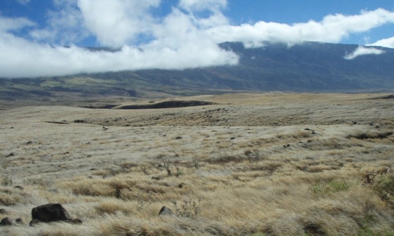
Figure 1. State 1. Reference Phase 1.1. Buffelgrass grass with piligrass. Naulu clouds on Haleakala in background. Waiakoa extremely stony silty clay loam, 3 to 25% slopes, eroded (WID2), elv. 100 feet, annual rainfall 20 inches. David Clausnitzer, 7/21/08.
State 1 Reference consists of three plant community phases dominated by introduced grasses with less than 25 percent canopy cover of introduced trees. The transition from one plant community within the state to another is often related to the dynamics of fire, grazing, and brush management.
Community 1.1
Buffelgrass with <25% kiawe cover

Figure 2. State 1. Reference Phase 1.1. Buffelgrass grass with piligrass. Naulu clouds on Haleakala in background. Waiakoa extremely stony silty clay loam, 3 to 25% slopes, eroded (WID2), elv. 100 feet, annual rainfall 20 inches. David Clausnitzer, 7/21/08.
Buffelgrass (Pennisetum ciliare) is the dominant forage species present. Kiawe (Prosopis pallida) and koa haole (Leucaena leucocephala) may be present. Kiawe is a potentially tall tree, up to 30 feet; its pods have forage value. If present at canopy cover greater than 25 percent, it can reduce production of grasses and forbs. Koa haole is a small tree that is browsed by livestock. Under continuous or excessively-heavy grazing, this phase will change to phase 1.2 Buffelgrass-pitted beardgrass with <25% kiawe cover. Buffelgrass (Pennisetum ciliare) comprises most of the productivity of this community phase. Other grass species that may be present area variety of guineagrass (Urochloa maxima) known as panicgrass - especially in pockets of increased moisture, native piligrass (Heteropogon contortus) and hardstem lovegrass (Eragrostis atropioides). Other species that may be present include desmanthus (Desmanthus virgatus), a leguminous shrub, uhaloa (Waltheria indica) and ‘akia (Wikstromia spp). In properly-managed areas, herbaceous plant basal cover is only interrupted by surface cobbles and stones, therefore this community has very little bare-ground patches.
Resilience management. Prescribed grazing, brush management, suppression of wildfires, and an extended fire return interval (10-15 years) are key components in maintaining this community phase. Where goat populations are high, vegetation damage can be intense, resulting in areas of bare soil and erosion, which if allowed to persist, may not stabilize on its own. The additional presence of deer on Maui and Molokai exacerbates this problem, producing bare soil or areas dominated by toxic or otherwise unpalatable forbs and sparse grasses.
Dominant plant species
-
kiawe (Prosopis pallida), tree
-
buffelgrass (Pennisetum ciliare), grass
Community 1.2
Buffelgrass – pitted beardgrass with <25% kiawe cover
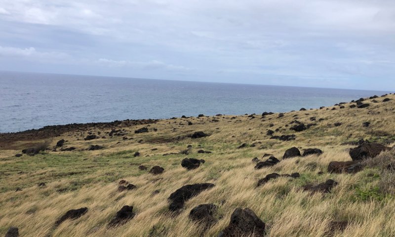
Figure 3. State 1. Reference Phase 1.2 Buffelgrass-pitted beardgrass mix. Waiakoa extremely stony silty clay loam, 3 to 25% slopes, eroded (WID2), elevation 50 feet, annual rainfall 20 inches. John Proctor, March 2021.
This community phase consists of perennial short-grass species that become abundant upon continuous grazing of buffelgrass. Further overgrazing exacerbates this process, causing transition to State 4. Toxic/Unpalatable Forb. An overstory of kiawe (Prosopis pallida) may be present at up to 25 percent canopy cover. Pitted beardgrass (Bothriochloa pertusa), broomsedge beardgrass (Andropogon virginicus) and swollen fingergrass (Chloris barbata) have increased in cover and production. Buffelgrass (Cenchrus ciliaris) is much reduced. Koa haole is much reduced compared with phase 1.1. Unpalatable species such as uhaloa (Waltheria indica), Japanese tea (Chamaecrista nictitans), Australian saltbush (Atriplex semibaccata), and golden crownbeard (Verbesina encelioides) have increased.
Resilience management. This plant community occurs under continuous grazing pressures that have been experienced consistently in the recent short-term past. This community provides less forage amounts (and forage quality) than Phase 1.1.1. It is the precursor plant community phase to Phase 1.1.3 (Sweet acacia (klu) / Bermudagrass/lantana), but has not been subjected to poor grazing management for as long.
Dominant plant species
-
kiawe (Prosopis pallida), tree
-
buffelgrass (Pennisetum ciliare), grass
-
pitted beardgrass (Bothriochloa pertusa), grass
Dominant resource concerns
-
Sheet and rill erosion
-
Wind erosion
-
Organic matter depletion
-
Plant productivity and health
Community 1.3
Sweet acacia (klu)/Bermudagrass/lantana
This community phase consists mostly of grass species that are highly tolerant of grazing, particularly Bermudagrass, along with increased amounts of unpalatable shrubs, forbs, and subshrubs. Koa haole is gone or is browsed down to stumps. Litter is reduced and bare ground is increasing and becoming common, so soil erosion by wind and water can be excessive. An overstory of kiawe (Prosopis pallida) may be present at up to 25 percent canopy cover. The most abundant grass species is Bermudagrass (Cynodon dactylon). Sweet acacia or klu (Acacia farnesiana) and lantana (Lantana camara) are common, unpalatable shrubs. Some native aalii (Dodonaea viscosa), ilima (Sida fallax), and uhaloa (Waltheria indica) typically are present.
Resilience management. This community phase occurs with long-term continuous grazing pressure resulting in significantly less forage amounts for grazing animals than other community phases within this State. Recognition of this community enables the landowner/manager to implement key management decisions before a significant economic/ecological threshold into State 4 Toxic/Unpalatable Forb is crossed.
Dominant plant species
-
sweet acacia (Acacia farnesiana), shrub
-
lantana (Lantana camara), shrub
-
Bermudagrass (Cynodon dactylon), grass
Dominant resource concerns
-
Sheet and rill erosion
-
Wind erosion
-
Organic matter depletion
-
Plant productivity and health
Pathway P1.1A
Community 1.1 to 1.2
Phase 1.1 can shift to phase 1.2 with continuous grazing. Buffelgrass cover and vigor are reduced by continuous grazing, causing it to decrease and be partially replaced by pitted beardgrass and other short grasses. With implementation of prescribed grazing and a planned grazing system, this shift is not expected to occur. Systematic defoliation by ungulates limits the growth (above and below ground) and reproduction of perennial grasses. The near continuous cover and vigor typical of buffelgrass in the Reference State 1. Phase 1.1 is reduced. This results in the creation of pockets of bare ground and the reduction of organic litter accumulation to the soil surface. Access to water is the greatest limiting factor to plant survival in this site. Water infiltration is reduced in areas of bare ground and/or reduced buffelgrass cover. Solar radiation penetration to the soil surface increases in areas of bare ground and/or reduced buffelgrass cover. These changes create a competitive advantage which favors the establishment and spread of pitted beardgrass (a less palatable perennial short grass). Buffelgrass becomes partially replaced by pitted beardgrass. With continued systematic herbivory, pitted beardgrass will become the dominant grass cover.
Context dependence. Where goat populations are high, vegetation damage can be intense, resulting in areas of bare soil and erosion, which if allowed to persist, may not stabilize on its own. The additional presence of deer on Maui and Molokai exacerbates this problem, producing bare soil or areas dominated by toxic or otherwise unpalatable forbs and sparse grasses.
Conservation practices
| Prescribed Grazing | |
|---|---|
| Planned Grazing System |
Pathway P1.2B
Community 1.2 to 1.1
Phase 1.2 can shift to phase 1.1 by application of a prescribed grazing program that allows buffelgrass to reassume dominance. Apply brush management and weed control as necessary. Continued rest from systematic defoliation by ungulates results in improved growth (above and below ground) and reproduction of perennial grasses. The cover and vigor of buffelgrass is increasing and their propagules are dispersing. Buffelgrass begins to replace pitted beardgrass as the dominant perennial grass cover. Litter accumulation is increasing, and bare ground is becoming infrequent on the landscape. Access to water is the greatest limiting factor to plant survival in this site. With decreased bare ground and increased buffelgrass cover, water infiltration increases markedly. Solar radiation penetration to the soil surface begins to decrease as perennial short-grasses are replaced by the taller buffelgrass. Soil erosion by wind and water is stabilized. These changes create a competitive advantage which favors the reestablishment and spread of buffelgrass. Buffelgrass has replaced pitted beardgrass as the dominant grass cover. Unpalatable shrubs (Lantana and Klu), forbs, and subshrubs have decreased.
Context dependence. Adequate spring and summer rain events help accelerate vegetative growth, reproduction, and reestablishment of buffelgrass.
Conservation practices
| Brush Management | |
|---|---|
| Prescribed Grazing | |
| Planned Grazing System | |
| Invasive Species Pest Management |
Pathway P1.2A
Community 1.2 to 1.3
Phase 1.2 shifts to phase 1.3 with long-term and/or heavy continuous grazing. Species composition changes to dominance by short-grasses, weedy forbs, and shrubs. Bare ground increases markedly. With implementation of prescribed grazing and a planned grazing system, and weed control and brush management as needed, this shift is not expected to occur. Long-term systematic defoliation by ungulates continues to limit the growth (above and below ground), reproduction of perennial grasses. The cover and vigor of buffelgrass-pitted beardgrass is greatly reduced. Mortality of these grass species are increasing, resulting in new niches for other species to colonize. Litter accumulation is greatly reduced, and bare ground is increasing and becoming common. Access to water is the greatest limiting factor to plant survival in this site. With increased bare ground and reduced perennial grass cover, water infiltration decreases markedly. Solar radiation penetration to the soil surface increases in areas of bare ground and/or reduced buffelgrass-pitted beardgrass cover. Soil erosion by wind and water are increasing. These changes create a competitive advantage which favors the establishment and further spread of bermudagrass as well as invasive shrub species. Phase 1.3 consists mostly of grass species that are highly tolerant of continued systematic herbivory, particularly Bermudagrass, along with increased amounts of unpalatable shrubs, forbs, and subshrubs. The Klu/Bermudagrass/Lantana community phase is a precursor to a shift to State 4.1. With implementation of Prescribed Grazing and a planned grazing system, these shifts are not expected to occur.
Context dependence. Where goat populations are high, vegetation damage can be intense, resulting in areas of bare soil and erosion, which if allowed to persist, may not stabilize on its own. The additional presence of deer on Maui and Molokai exacerbates this problem, producing bare soil or areas dominated by toxic or otherwise unpalatable forbs and sparse grasses.
Conservation practices
| Brush Management | |
|---|---|
| Prescribed Grazing | |
| Planned Grazing System | |
| Invasive Plant Species Control | |
| Invasive Species Pest Management |
Pathway P1.3A
Community 1.3 to 1.2
Phase 1.3 can shift to phase 1.2 by application of a prescribed grazing program that allows pitted beardgrass and buffelgrass to reassume dominance. Intensive weed and brush control may be necessary. Measures to control wind and water erosion may also be needed. Adequate rest from long-term systematic defoliation by ungulates results in improved growth (above and below ground) and reproduction of perennial grasses. The cover and vigor of buffelgrass and pitted beardgrass are increasing and their propagules are dispersing. Pitted beardgrass may still be the dominant perennial grass cover. Buffelgrass and pitted beardgrass recolonize new niches which have resulted from weed control and brush control efforts. Litter accumulation is increasing, and bare ground is becoming less common. Access to water is the greatest limiting factor to plant survival in this site. With decreased bare ground and increased perennial grass cover water infiltration increases. Solar radiation penetration to the soil surface begins to decrease. Soil erosion by wind and water is stabilizing. These changes create a competitive advantage which favors the reestablishment and spread of buffelgrass and pitted beard grass, which can also limit the additional spread of invasive shrub species. Buffelgrass and pitted beardgrass have replaced bermudagrass as the dominant grass covers.
Context dependence. Adequate spring and summer rain events help accelerate vegetative growth, reproduction, and reestablishment of buffelgrass and pitted beardgrass.
Conservation practices
| Brush Management | |
|---|---|
| Prescribed Grazing | |
| Planned Grazing System | |
| Invasive Plant Species Control | |
| Invasive Species Pest Management |
State 2
Kiawe-Invaded
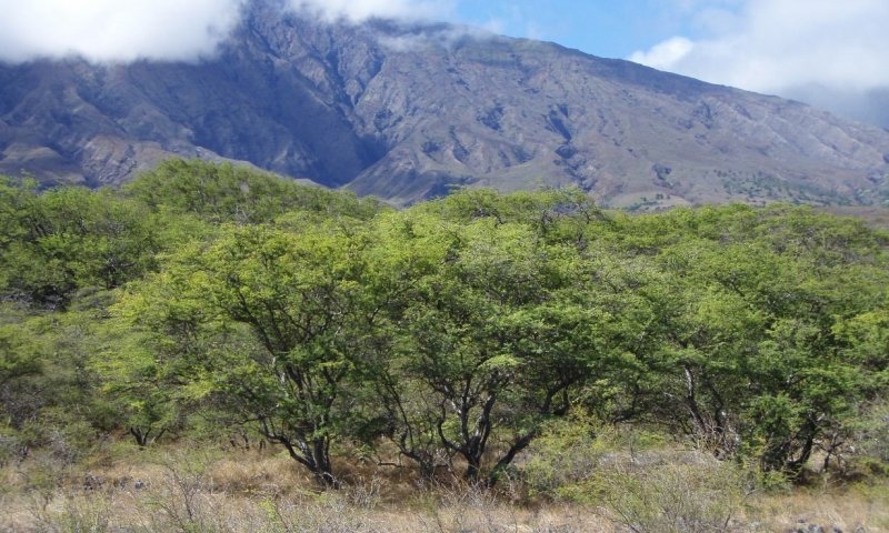
Figure 4. State 2.1. Kiawe-Invaded State. Understory is buffelgrass and other introduced grasses. Rock Land (rRK), elevation near sea level, annual rainfall 35 inches. David Clausnitzer, 7/28/08.
State 2 Kiawe-Invaded consists of one community phase. It occurs when brush management has not been practiced or if wildfire has not occurred for a long time, allowing kiawe to increase in density and stature to a level at which understory production is significantly reduced.
Community 2.1
Buffelgrass with >25% kiawe cover
Kiawe canopy cover is 25 percent or higher. The understory consists of remnant buffelgrass and other grasses. Grass cover has been reduced beneath the dense tree canopy. Bare ground has increased, and there may be shallow, seasonal stream channels cut into the soil.
Resilience management. To cross a threshold back to State 1, a fire return interval <15 years is needed, and likely additional brush management strategies to avoid proliferation of invasive shrubs (lantana, klu, koa-haole, etc). Prescribed grazing strategies allowing for sufficient rest of herbaceous forages will be needed as well. Conversion from State 2 back to any community in State 1 will require extensive labor, time and money.
Dominant plant species
-
kiawe (Prosopis pallida), tree
-
buffelgrass (Pennisetum ciliare), grass
Dominant resource concerns
-
Sheet and rill erosion
-
Plant productivity and health
State 3
Native Savanna
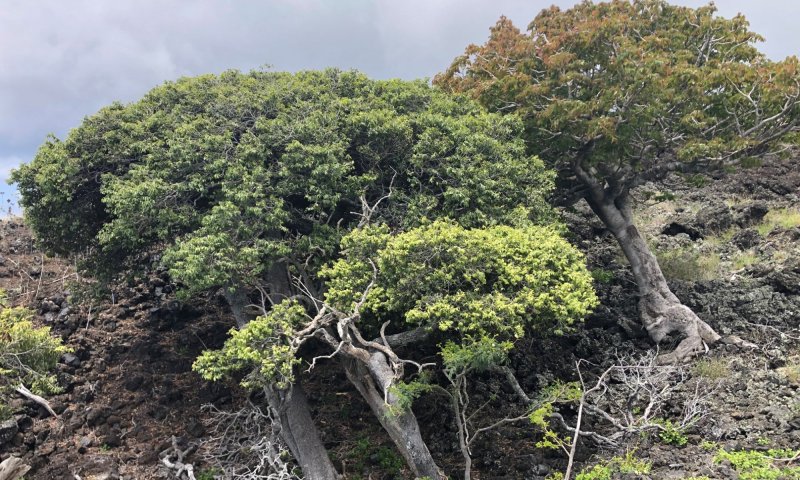
Figure 5. State 3. Native Savanna State. These native, relic Ohe makai and Lama trees on Maui near Kahikinui provide a theoretical representation of the restored Native Savanna State. John Proctor. March 2021.
State 3 Native Savanna consists of one community phase. Intact examples of this community no longer exist within this Ecological Site. Currently only 5-10% of dry forests remain in Hawaii and less than 3% are considered healthy. No other vegetation zone in the islands has been so significantly altered. As such, this description is compiled from field observations of remnant vegetation, isolated plants on disturbed sites, a similar ecological site on the Island of Hawaii, and historical accounts.
Characteristics and indicators. Dry forests/savannas in Hawaii maintain and promote healthy soils by limiting both water and wind erosion (Nahelehele Dryland Forest Symposium 2019). They also sequester carbon, produce oxygen, help to replenish drinking water aquifers, create cool micro-climates and provide many other ecosystem services necessary for life on the planet. They are the exclusive home of many endangered native plants, birds and insects. By preserving native species, we preserve biodiversity and genetic information and open more possibilities for the evolution of plants and animals to thrive in future environments.
Resilience management. Dry forests/savannas play a crucial role in the cultural health and traditions for Hawaiian people (Nahelehele Dryland Forest Symposium 2019). It is deeply believed to “take care of the land and the land will take care of you”. The ancient Hawaiian conservation management system of Kapu or restrictions to protect scarce resources is no longer in place. However the foundation for that thinking is still valued by many today, who believe the highest relationship with these rare grandparent or kupuna trees, has become the spiritual guidance and comfort that is offered by their living presence—and we should mālama or care for them as with any beloved elder.
Community 3.1
Wiliwili – ohe makai/ilima
The hypothetical appearance of this community phase is an open canopy of low to medium height (15-25 feet; 4.5 to 8 meters) trees, a shrub understory, and a ground layer of vines, herbs, and grasses. The species present would be typical of other low elevation dry Hawaiian sites. Tree species may include wiliwili (Erythrina sandwicense), ohe makai (Polyscias sandwicensis), koaia (Acacia koaia), lama (Diospyros sandwicensis), kului (Nototrichium sandwicense), hao (Rauvolfia sandwicensis), and alahee (Psydrax odoratum). Shrubs may include maiapilo or native caper (Capparis sandwichiana), aheahea (Chenopodium oahuense), akoko (Euphorbia spp.), mao or Hawaiian cotton (Gossypium tomentosum), iliahi (Santalum ellipticum), and ilima (Sida fallax). Some common vines would be huehue (Cocculus orbiculatus), dodder (Cuscuta campestris), pauohiiaka (Jacquemontia sandwicensis), and koali awa (Ipomoea indica). A large number of forbs, grasses, and grasslike species would be present.
Resilience management. To protect and maintain this community the site must be fenced to exclude all domestic and feral ungulates. A firebreak must be established and maintained around the fence line by grazing or mowing. A long-term Integrated Pest Management program must be established and maintained that includes early detection and rapid response of invasive plant species or pathogens which may threaten this plant community.
Dominant plant species
-
wili wili (Erythrina sandwicensis), tree
-
'ohe makai (Reynoldsia sandwicensis), tree
-
yellow ‘ilima (Sida fallax), shrub
Dominant resource concerns
-
Plant pest pressure
-
Terrestrial habitat for wildlife and invertebrates
State 4
Toxic/unpalatable Forb
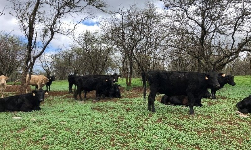
Figure 6. State 4. Toxic/Unpalatable Forb. Caused and maintained primarily by constant heavy browsing and grazing by feral goats and/or deer. Waiakoa extremely stony silt clay loam, 3 to 25% MU. Elevation ~ 1,000 feet. John Proctor. Feb 05, 2021.
State 4 Toxic/Unpalatable Forb consists of one community phase vegetated mostly with toxic or otherwise highly unpalatable plants; kiawe may be present in varying amounts. It is caused and maintained primarily by constant heavy browsing and grazing by feral goats and/or deer.
Dominant resource concerns
-
Plant productivity and health
-
Plant structure and composition
-
Feed and forage imbalance
Community 4.1
Golden crownbeard-Chenopodium
with or without kiawe
Where there is no kiawe canopy (Big Island), the site goes to bare ground and starts to erode. Where there is kiawe to create a shaded microclimate, toxic forbs have replaced all acceptable forages. Some of the most common forbs in this community phase are golden crownbeard (Verbesina encelioides), scarlet spiderling (Boerhaviacoccinea), keeled wormseed (Dysphania carinata syn. Chenopodium carinatum), Santa Maria feverfew (Parthenium hysterophorus), coffee senna or septicweed (Senna occidentalis) and khakiweed (Alternanthera pungens). Perrenial shortgrass species such as pitted beardgrass (Bothriochloa pertusa) may be sparsely present. Bare ground patches are large and frequently connected.
Resilience management. Many of these forbs behave more like annuals and will die during prolonged dry conditions. As such these sites are very prone to serious soil erosion. Management and significant reduction in the numbers of the feral animals in the area is necessary. This may involve fencing, trapping, and other herd reduction methods. The soil seed bank will probably bring back a variety of plant species in a favorable weather year but seeding of desired forages or native plants is recommended, along with continuous weed and brush control as necessary. Sites that are severely eroded may require additional management inputs and conservation practices.
Dominant plant species
-
kiawe (Prosopis pallida), tree
-
pitted beardgrass (Bothriochloa pertusa), grass
-
golden crownbeard (Verbesina encelioides), other herbaceous
-
scarlet spiderling (Boerhavia coccinea), other herbaceous
-
keeled wormseed (Dysphania carinata), other herbaceous
-
Santa Maria feverfew (Parthenium hysterophorus), other herbaceous
-
septicweed (Senna occidentalis), other herbaceous
-
khakiweed (Alternanthera pungens), other herbaceous
Dominant resource concerns
-
Sheet and rill erosion
-
Wind erosion
-
Organic matter depletion
-
Plant productivity and health
-
Plant structure and composition
-
Feed and forage imbalance
Transition T1A
State 1 to 2
State 1 Reference transitions to State 2 Kiawe Invaded in the absence of disturbance such as fire or brush management. Kiawe seedlings are usually found associated with animal droppings and are intolerant of shade. As such, the continuous Buffelgrass cover typical of State 1 (Reference), Phase 1.1 can limit kiawe establishment while the dominance of perennial short grasses and increasing bare ground typified in State 1, Phase 1.2 and Phase 1.3 can provide kiawe seedlings an advantage to establish. Kiawe seedling survival depends primarily on sufficient rainfall during 4 to 6 weeks after germination. As recruitment and dispersal progress, kiawe begins to out compete perennial grasses for water, soil nutrients, and light. Access to water is the greatest limiting factor to plant survival in this site. As a phreatophyte kiawe thrives where it has access to both soil moisture and ground water. Kiawe develops an overstory canopy cover that reduces solar radiation penetration to the soil surface which can result in reduced production and cover of buffelgrass and other forages beneath the dense tree canopy. Areas of bare ground increase and there may be shallow, seasonal stream channels cut into the soil.
Constraints to recovery. Conversion from State 2 back to any community in State 1 will require extensive labor, time, and money. Kiawe may cause changes in local hydrology and mineral cycling due to it’s efficient water harvesting capability and nitrogen fixation (Dudley, 2014). Controlling kiawe by mechanical means can cause soil disturbance impacts. Kiawe and weedy species from the seed bank may flourish after kiawe trees are removed. This is exacerbated in areas where the soils are disturbed.
Conservation practices
| Brush Management | |
|---|---|
| Firebreak | |
| Land Clearing | |
| Planned Grazing System | |
| Prescribed Grazing |
Restoration pathway R1A
State 1 to 3
State 1 Reference can be restored and maintained to State 3 Native Savanna with significant management inputs. The site must be fenced or other measures must be taken to exclude all domestic and feral ungulates. A firebreak must be established and maintained around the fence line by grazing or mowing. Buffelgrass and other non-native vegetation must be killed, followed by plantings of native trees, shrubs, and vines. Supplemental irrigation may be necessary in the early stages of restoration. Expected Effects: Increased litter accumulation, increased nutrient availability, increased water infiltration, reduced solar radiation, increased soil moisture, genetic conservation, enhanced wildlife habitat including improved pollinator forage and nesting.
Context dependence. Conversion from any community in State 1 Reference to State 3 Native Savanna will require extensive and sustained labor, time, and money.
Conservation practices
| Fence | |
|---|---|
| Firebreak | |
| Irrigation System, Microirrigation | |
| Tree/Shrub Establishment | |
| Restoration and Management of Rare and Declining Habitats | |
| Native Plant Community Restoration and Management | |
| Fuel Break | |
| Invasive Plant Species Control | |
| Conservation Plan Development | |
| Conservation Plan Implementation | |
| Invasive Species Pest Management | |
| Establish pollinator and/or beneficial insect habitat |
Transition T1B
State 1 to 4
State 1 Reference transitions and is maintained to State 4 Toxic/Unpalatable Forb primarily by constant heavy browsing and grazing by feral goats and on Maui and Molokai, deer, such that nearly all perennial grass and forb (forages) are removed. To avoid this transition, management and significant reduction in the numbers of the feral animals in the area is necessary. This may involve fencing, trapping, and other herd reduction methods. Large patches of mortality within the grass and forb functional groups are becoming common on the landscape. In areas where groundcover has persisted, the cover and vigor of perennial grass and forbs have become greatly reduced. Litter accumulation is greatly reduced to non-existent, and bare ground patches are large and frequently connected. This results in the creation of large barren areas suitable for toxic forbs to colonize. Access to water is the greatest limiting factor to plant survival in this site. Water infiltration is greatly reduced in areas of bare ground and/or reduced perennial grass cover. Solar radiation penetration to the soil surface increases significantly in areas of bare ground and/or reduced perennial grass cover. These changes create a competitive advantage which favors the establishment and further spread of toxic/unpalatable forbs as well as invasive shrub species.
Constraints to recovery. Conversion from State 4 Toxic/Unpalatable Forb back to any community in State 1 Reference will require extensive and sustained labor, time, and money.
Restoration pathway R2A
State 2 to 1
State 2 Kiawe-Invaded can be restored to State 1 Reference when kiawe are cleared by fire, herbicidal application, or mechanical means. While fire will kill kiawe, prescribed burning is typically not done in Hawaii due to the level of risk to relict native ecosystems and enjoined or embedded development. Once cleared, perennial grasses and forbs reassume dominance where they have regained access to soil moisture, nutrients and light. Additional brush management strategies to avoid the proliferation of invasive shrubs (lantana, klu, koa-haole, etc) will be required and prescribed grazing strategies allowing for sufficient rest of perennial grasses and forbs will be needed. Fire: The effects of fire impacts on plant populations and habitat quality depend on fire severity (high, medium low), habitat type burned, species biology, timing of burning (wet or dry), plant phenology (stage of plant development when burned) and site conditions (e.g. topography, moisture (Brown et al 2000). Fire will kill Kiawe and will also reduce its postfire recruitment through direct mortality of the seeds on or near the surface (Gallaher and Merlin 2010, Smith and Tunison 1992). However, vigorous regeneration from the seed bank can occur in areas of high ground disturbance. Invasive, fire-prone grasses such as buffelgrass encourage wildfire because they ignite and spread wildfire quickly (HWMO 2019). Non-native savannas in Hawaii that are not grazed create hazardous fuels which result in wildfire frequency and increased increased rates of erosion and sediment transport to the ocean. These alien grasses usually recover to pre-burn levels and often intensify after fire. Fire thus promotes conditions that increase fire frequency and size by increasing the continuity and/or fuel loadings of alien grasses (Smith and Tunison 1992). Many native species, for example, wiliwili and lama, remaining in this ecological are not adapted to fire. For this reason, relictual native woodlands are now threatened by fine fuel loading from alien grasses. Mechanical Control: Some mechanical techniques that have been employed successfully include blade plowing, chain pulling, bulldozing, and stick raking (Gallaher and Merlin 2010). These methods can create high levels of ground disturbance and soil compaction. Herbicidal Control. Basal bark and cutstump application of have been employed in Hawaii. Although this method works well for isolated individuals, it is both cost- and time-prohibitive for large areas with dense stands.
Context dependence. Conversion from State 2 Kiawe-Invaded back to any community in State 1 Reference will require extensive labor, time, and money. Prescribed burning is not, on the whole, an effective management tool in Hawai`i, although it may have potential limited management and research value (Smith and Tunison 1992). Moreover, the intensification of fire-prone alien grasses following fire assures the increased incidence of fire, thereby establishing a self-perpetuating alien grass/fire cycle. The effects of fire argue strongly that all agencies responsible for the management of fire in natural areas in Hawai`i should aggressively suppress all fires, whether caused by lava flows, lightning, or humans.
Conservation practices
| Brush Management | |
|---|---|
| Land Clearing | |
| Planned Grazing System | |
| Prescribed Grazing | |
| Invasive Plant Species Control |
Transition T3A
State 3 to 1
State 3 Native Savanna transitions to State 1 Reference when it is cleared by fire, long-term ungulate disturbance, or mechanical means. Once cleared, desired perennial grass and forbs (typically naturalized forage species) are then re-established. While fire will kill most native vegetation, prescribed burning is typically not done in Hawaii due to the level of risk to other enjoined or embedded relict native ecosystems and development. These disturbances initiate change by affecting the composition, structure, and pattern of vegetation on the landscape (Brown et al 2000). They affect plants directly, by injury and mortality, and indirectly, by changing resource availability including light, nutrients, pollinators, and mutually beneficial microorganisms such as mycorrhizae, translating into vegetation changes (clearing) at the plant, population, and community level. Fire Effects: Fires of all intensities, timing, and causes are harmful to most native ecosystems in Hawai`i (Smith and Tunison 1992). Alien species, particularly grasses such as buffelgrass, recover rapidly and fill in the spaces left by native plants, which recover more slowly, if at all. In Hawaii, fires establish a destructive cycle by increasing fuel loadings of flammable alien grasses, which in turn increase fire frequency and fire size. Subsequent burns further inhibit the reestablishment of native trees species. Some native species easily killed by fire include wiliwili, lama, and akia (Smith and Tunison 1992). Native species tolerant (aerial portions of all native plant species are readily killed by fire, but some resprout or recover from seed) to a very low frequency of fire, recover to some degree after burns, but typically to populations far less than those found in pre-burn conditions because they typically must compete with fire-stimulated alien grasses. Naio (Myoporum sandwicense) resprouts after fire as long as the fire is not too intense. Regrowth is slow and the original canopy cover takes over five years to regenerate. The seeds of `a`ali`i (Dodonaea viscosa) germinate readily after fire, but it is not known if they are fire-stimulated. `A`ali`i may reach higher densities after fire than before. Most native bunchgrasses recover rapidly after burning. Piligrass resprouts readily with a significant increase in cover following low-intensity fire. Long-Term Systematic Herbivory Effects: With continued, long-term systematic herbivory and browsing by goats and, on Molokai and Maui, deer, nearly all native grass and forbs (forages) and regenerating shrub and tree seedlings are removed allowing buffelgrass to resume dominance.
Conservation practices
| Brush Management | |
|---|---|
| Range Planting | |
| Planned Grazing System | |
| Prescribed Grazing | |
| Invasive Plant Species Control |
Restoration pathway R4A
State 4 to 1
State 4 Toxic/Unpalatable Forb is restored to State 1 Reference with significant management inputs. Management and significant reduction in the numbers of the feral animals in the area is necessary. This may involve fencing, trapping, and other herd reduction methods. The soil seed bank will probably bring back a variety of plant species in a favorable weather year but seeding of desired forages or native plants is recommended, along with continuous weed and brush control as necessary. Sites that are severely eroded may require additional management inputs and conservation practices. Expected Effects: Rest from continued disturbance, soil stabilization, reduced soil rrosion (wind and water), recruitment and dispersal of perennial grasses, increased perennial grass cover, reduced toxic/unpalatable forb abundance/cover, decreased solar radiation to soil surface, soil stabilization, and increased water infiltration to the soil.
Context dependence. Adequate spring and summer rain events help accelerate vegetative growth, reproduction, and reestablishment of perennial grasses including buffelgrass and pitted beardgrass.
Conservation practices
| Brush Management | |
|---|---|
| Fence | |
| Range Planting | |
| Planned Grazing System | |
| Prescribed Grazing | |
| Invasive Plant Species Control | |
| Invasive Species Pest Management |
Additional community tables
Interpretations
Supporting information
Other references
Other Information
Definitions
These definitions have been greatly simplified for brevity and do not cover every aspect of each topic.
Aa lava: A type of basaltic lava having a rough, jagged, clinkery surface and a vesicular interior.
Alluvial: Materials or processes associated with transportation and/or deposition by running water.
Aquic soil moisture regime: A regime in which the soil is free of dissolved oxygen because it is saturated by water. This regime typically exists in bogs or swamps.
Aquisalids: These are salty soils in wet areas. Although wet, the dissolved salts make the soils physiologically dry (the chemical activity, or effective concentration, of water is low). Aquisalids typically support plant species that are adapted to these conditions.
Aridic soil moisture regime: A regime in which defined parts of the soil are, in normal years, dry for more than half of the growing season and moist for less than 90 consecutive days during the growing season. In Hawaii it is associated with hot, dry areas with plants such as kiawe, wiliwili, and buffelgrass. The terms aridic and torric are basically the same.
Ash field: a land area covered by a thick or distinctive deposit of volcanic ash that can be traced to a specific source and has well defined boundaries. The term “ash flow” is erroneously used in the Physiographic section of this ESD due to a flaw in the national database.
Ashy: A “soil texture modifier” for volcanic ash soils having a water content at the crop wilting point of less than 30 percent; a soil that holds relatively less water than “medial” and “hydrous” soils.
Available water capacity: The amount of soil water available to plants to the depth of the first root-restricting layer.
Basal area or basal cover: The cross sectional area of the stem or stems of a plant or of all plants in a stand.
Blue rock: The dense, hard, massive lava that forms the inner core of an aa lava flow.
Bulk density: the weight of dry soil per unit of volume. Lower bulk density indicates a greater amount of pore space that can hold water and air in a soil.
CaCO3 equivalent: The amount of free lime in a soil. Free lime exists as solid material and typically occurs in regions with a dry climate.
Canopy cover: The percentage of ground covered by the vertical projection downward of the outermost perimeter of the spread of plant foliage. Small openings within the canopy are included.
Community pathway: A description of the causes of shifts between community phases. A community pathway is reversible and is attributable to succession, natural disturbances, short-term climatic variation, and facilitating practices, such as grazing management.
Community phase: A unique assemblage of plants and associated dynamic soil properties within a state.
Dominant species: Plant species or species groups that exert considerable influence upon a community due to size, abundance, or cover.
Drainage class: The frequency, duration, and depth of a water table in a soil. There are seven drainage classes, ranging from “excessively drained” (soils with very rare or very deep water tables) to “well drained” (soils that provide ample water for plant growth but are not so wet as to inhibit root growth) to “very poorly drained” (soils with a water table at or near the surface during much of the growing season that inhibits growth of most plants).
Electrical conductivity (EC): A measure of the salinity of a soil. The standard unit is deciSiemens per meter (dS/m), which is numerically equivalent to millimhos per centimeter (mmhos/cm). An EC greater than about 4 dS/m indicates a salinity level that is unfavorable to growth of most plants.
Friability: A soil consistency term pertaining to the ease of crumbling of soils.
Gleyed: A condition of soil from which iron has been reduced (in the redox chemistry sense) and removed during soil formation or that saturation with stagnant water has preserved a reduced state. If iron has been removed, the soil is the color of uncoated sand and silt particles. If iron is present in a reduced state, the soil is the color of reduced iron (typically bluish-gray). Redox concentrations (spots of oxidized iron, formerly called mottles are often present.
Hydrous: A “soil texture modifier” for volcanic ash soils having a water content at the crop wilting point of 100 percent or more; a soil that holds more water than “medial” or “ashy” soils.
Ion exchange capacity: The ability of soil materials such as clay or organic matter to retain ions (which may be plant nutrients) and to release those ions for uptake by roots.
Isohyperthermic soil temperature regime: A regime in which mean annual soil temperature is 72 degrees F (22 degrees C) or higher and mean summer and mean winter soil temperatures differ by less than 11 degrees F (6 degrees C) at a specified depth.
Isomesic soil temperature regime: A regime in which mean annual soil temperature is 47 degrees F (8 degrees C) or higher but lower than 59 degrees F (15 degrees C) and mean summer and mean winter soil temperatures differ by less than 11 degrees F (6 degrees C) at a specified depth.
Isothermic soil temperature regime: A regime in which mean annual soil temperature is 59 degrees F (15 degrees C) or higher but lower than 72 degrees F (22 degrees C) and mean summer and mean winter soil temperatures differ by less than 11 degrees F (6 degrees C) at a specified depth.
Kipuka: An area of land surrounded by younger (more recent) lava. Soils and plant communities within a kipuka are older than, and often quite different from, those on the surrounding surfaces.
Major Land Resource Area (MLRA): A geographic area defined by NRCS that is characterized by a particular pattern of soils, climate, water resources, and land uses. The island of Hawaii contains nine MLRAs, some of which also occur on other islands in the state.
Makai: a Hawaiian word meaning “toward the sea.”
Mauka: a Hawaiian word meaning “toward the mountain” or “inland.”
Medial: A “soil texture modifier” for volcanic ash soils having a water content at the crop wilting point of 30 to 100 percent; a soil that holds an amount of water intermediate to “hydrous” or “ashy” soils.
Mollisols: Soils with relatively thick, dark surface horizons, high cation-exchange capacity, high calcium content, that do not become hard or very hard when dry. Mollisols are conducive to plant growth. They characteristically form under grass in climates that are seasonally dry but can form under forests.
Naturalized plant community: A community dominated by adapted, introduced species. It is a relatively stable community resulting from secondary succession after disturbance. Most grasslands in Hawaii are in this category.
Oxisols: Soils characteristic of humid, tropical or subtropical regions that formed on land surfaces that have been stable for a long time. In Hawaii, they typically occur on islands or parts of islands that have been volcanically inactive for a long time. Oxisols are highly weathered, consist largely of quartz, kaolin clays, and aluminum oxides, and have low ion exchange capacity and loamy or clayey texture.
Pahoehoe lava: A type of basaltic lava with a smooth, billowy, or rope-like surface and vesicular interior.
Parent material: Unconsolidated and chemically weathered material from which a soil is developed.
Perudic soil moisture regime: A very wet regime found where precipitation exceeds evapotranspiration in all months of normal years. On the island of Hawaii, this regime is found on top of Kohala and on parts of the windward side of Mauna Kea.
pH: The numerical expression of the relative acidity or alkalinity of a soil sample. A pH of 7 is neutral; a pH below 7 is acidic and a pH above 7 is basic.
Phosphorus adsorption: The ability of soil materials to tightly retain phosphorous ions, which are a plant nutrient. Some volcanic ash soils retain phosphorus so strongly that it is partly unavailable to plants.
Psamments: Sandy soils that have low water-holding capacity, are susceptible to wind erosion, and typically have ground water deeper than 20 inches (50 centimeters).
Reference community phase: The phase exhibiting the characteristics of the reference state and containing the full complement of plant species that historically occupied the site. It is the community phase used to classify an ecological site.
Reference state: A state that describes the ecological potential and natural or historical range of variability of an ecological site.
Residuum: Unconsolidated mineral material that has chemically and physically weathered from rock and has not moved from its place of origin.
Restoration pathway: A term describing the environmental conditions and practices that are required to recover a state that has undergone a transition.
Sodium adsorption ratio (SAR): A measure of the amount of dissolved sodium relative to calcium and magnesium in the soil water. SAR values higher than 13 create soil conditions unfavorable to most plants.
Soil moisture regime: A term referring to the presence or absence either of ground water or of water held at a tension of less than 1500 kPa (the crop wilting point) in the soil or in specific horizons during periods of the year.
Soil temperature regime: A defined class based on mean annual soil temperature and on differences between summer and winter temperatures at a specified depth.
Soil reaction: Numerical expression in pH units of the relative acidity or alkalinity or a soil.
Spodosols: Soils with a spodic B horizon that has an accumulation of black or reddish amorphous materials that have a high pH-dependent ion exchange capacity, coarse texture, and few base cations. Above the spodic horizon there often is a light-colored albic horizon that was the source of the amorphous materials in the spodic horizon.
State: One or more community phases and their soil properties that interact with the abiotic and biotic environment to produce persistent functional and structural attributes associated with a characteristic range of variability.
State-and-transition model: A method used to display information about relationships between vegetation, soil, animals, hydrology, disturbances, and management actions on an ecological site.
Torric soil moisture regime: See Aridic soil moisture regime.
Transition: A term describing the biotic or abiotic variables or events that contribute to loss of state resilience and result in shifts between states.
Udic soil moisture regime: A regime in which the soil is not dry in any part for as long as 90 cumulative days in normal years, and so provides ample moisture for plants. In Hawaii it is associated with forests in which hapuu (tree ferns) are usually moderately to highly abundant.
Ultisols: Soils that have been intensively leached and weathered. They have a B horizon that has accumulated clay that has translocated there from higher horizons. They have moderate to low cation exchange capacity and low base saturation. The highest base saturation normally is in the few centimeters directly beneath the surface due to cycling of bases by plants.
Ustic soil moisture regime: A regime in which moisture is limited but present at a time when conditions are suitable for plant growth. In Hawaii it usually is associated with dry forests and subalpine shrublands.
Other References
Abrahamson I. 2013. Fire regimes in Hawaiian plant communities. In: Fire Effects Information System, US Dept. of Agriculture, Forest Service, Rocky Mountain Research Station, Fire Sciences Laboratory. Available" www.fs.fed.us/database/feis/fire_regimes/Hawaii/all.html
Allen, M.S., 2014. Marquesan colonization chronologies and post colonization interaction: implications for Hawaiian origins and the ‘Marquesan Homeland’ hypothesis. Journal of Pacific Archaeology, 5(2), pp.1-17. Discussions of earliest Polynesian migrations to Hawaii.
Armstrong RW. 1973. Atlas of Hawaii. University of Hawaii Press, Honolulu.
Athens JS. Ch. 12 Hawaiian Native Lowland Vegetation in Prehistory in Historical Ecology in the Pacific Islands – Prehistoric Environmental and Landscape Change. Kirch, PV and TL Hunt, eds. 1997. Yale U. Press, New Haven.
Brown, James K.; Smith, Jane Kapler, eds. 2000. Wildland fire in ecosystems: effects of fire on flora. Gen. Tech. Rep. RMRS-GTR-42-vol.2. Ogden, UT: U.S. Department of Agriculture, Forest Service, Rocky Mountain Research Station. 257 p. General discussion of effects of fire impacts on composition, structure, and pattern of vegetation on the landscape.
Burney DA, HF James, LP Burney, SL Olson, W Kikuchi, WL Wagner, M Burney, D McCloskey, D Kikuchi, FV Grady, R Gage II, and R Nishek. 2001. Fossil evidence for a diverse biota from Kauai and tis transformation since human arrival. Ecological Monographs 71:615-641.
Christensen CC. 1983. Report 17: Analysis of land snails. In: Archaeological investigations of the Mudlane-Waimea-Kawaihae Road Corridor, Island of Hawaii: An Interdisciplinary Study of an Environmental Transect. Clark JT. and Kirch PV, eds. Dept. of Anthropology, Bernice Pauahi Bishop Museum, Report 83-1, Honolulu, HI.
Clark JT. 1983. Report 3: The Waimea-Kawaihae Region: Historical Background. In: Archaeological investigations of the Mudlane-Waimea-Kawaihae Road Corridor, Island of Hawaii: An Interdisciplinary Study of an Environmental Transect. Clark JT and Kirch PV, eds. Dept. of Anthropology, Bernice Pauahi Bishop Museum, Report 83-1, Honolulu, HI.
Clark JT. 1983. Report 7: Archaeological investigations in Section 4. In: Archaeological investigations of the Mudlane-Waimea-Kawaihae Road Corridor, Island of Hawaii: An Interdisciplinary Study of an Environmental Transect. Clark JT and Kirch PV, eds. Dept. of Anthropology, Bernice Pauahi Bishop Museum, Report 83-1, Honolulu, HI.
Clark JT. 1983. Report 8: Archaeological investigations of agricultural sites in the Waimea area. In: Archaeological investigations of the Mudlane-Waimea-Kawaihae Road Corridor, Island of Hawaii: An Interdisciplinary Study of an Environmental Transect. Clark JT and Kirch PV, eds. Dept. of Anthropology, Bernice Pauahi Bishop Museum, Report 83-1, Honolulu, HI.
Craighill ES and EG Handy. 1991. Native Planters in Old Hawaii – Their Life, Lore, and Environment. Bernice P. Bishop Museum Bulletin 233, Bishop Museum Press, Honolulu, HI
Cuddihy LW and CP Stone. 1990. Alteration of Native Hawaiian Vegetation: Effects of Humans, Their Activities and Introductions. Honolulu: University of Hawaii Cooperative National Park Resources Study Unit.
Deenik J and AT McClellan. 2007. Soils of Hawaii. Soil and Crop Management, Sept. 2007, SCM-20. Cooperative Extension Service, College of Tropical Agriculture and Human Resources. University of Hawaii at Manoa. Available online at: https://www.ctahr.hawaii.edu/oc/freepubs/pdf/SCM-20.pdf
Dixon JB and Schulze DG, eds. 2002. Soil Mineralogy with Environmental Applications. Volume 7. Soil Science Society of America. Available online at: https://acsess.onlinelibrary.wiley.com/doi/book/10.2136/sssabookser7
Gallagher T and M Merlin. 2010. Biology and Impacts of Pacific Island Invasive Species. 6. Prosopis pallida and Prosopis juliflora (Algarroba, Mesquite, Kiawe) (Fabaceae). Pacific Science 64(4): 489-526. Doi: 10.2984/64.4.489. Discussion of the survival adaptations(phreatophyte) of Kiawe, its population biology mechanisms (recruitment, dispersal, establishment, survival), known control methods, and how it is affected by fire.
Giambelluca TW and TA Schroeder. 1998. Climate. In: Atlas of Hawaii, 3rd edition. SP Juvik, JO Juvik, and RR Paradise, eds. pp. 49-59. Honolulu: University of Hawaii Press.
Gil CR. 2016-2017. Ananas comosus. Colegio Bolivar Agricultural Science. Available online at: https://www.colegiobolivar.edu.co/garden/wp-content/uploads/2017/06/Crosas-Ananas-comosus-2017.pdf
Handy ESC Handy EG and Pukui MK. 1972. Native Planters in Old Hawaii Their Life, Lore, and Environment. (Revised Edition, 1991). Bernice P. Bishop Museum Bulletin 233. Honolulu.
Hazlett RW and DW Hyndman. 1996. Roadside Geology of Hawaii. Mountain Press Publishing Company, Missoula MT.
Henke LA. 1929. A Survey of Livestock in Hawaii. Research Publication No. 5. University of Hawaii, Honolulu.
Horrocks M. 2009. Sweet potato (Ipomoea batatas) and banana (Musa sp.) microfossils in deposits from the Kona Field System, Island of Hawaii. Journal of Archaeological Science, May 2009.
Imada, C. 2012. Hawaiian Native and Naturalized Vascular Plants Checklist (December 2012 update). Bishop Museum Technical Report 60. Bishop Museum Press, Honolulu.
Jacobi JD. 1989. Vegetation Maps of the Upland Plant Communities on the Islands of Hawaii, Maui, Molokai, and Lanai. Technical Report 68. Cooperative National Park Resources Studies Unit, University of Hawaii at Manoa and National Park Service.
Juvik JO and D Nullet. 1993. Relationships between rainfall, cloud-water interception, and canopy throughfall in a Hawaiian montane forest. IN: Tropical Montane Cloud Forests. Proc. Int. Sym., San Juan, PR. Hamilton LS, JO Juvik, and FN Scatena, eds. East-West Center.
Kekona, Kaipo. 2021. Proctor personal communication to Kaipo Kekona (Ku'ia Agricultural Education Center) and the Kapu Ohana (Lahaina Cultural Center) discussing the extensive agricultural and water system history of Lahaina pre- and post-colonial history.
Kirch PV. 1982. The impact of the prehistoric Polynesians in the Hawaiian ecosystem. Pacific Science 36(1):1-14.
Kirch PV. 1983. Introduction. In: Archaeological investigations of the Mudlane-Waimea-Kawaihae Road Corridor, Island of Hawaii: An Interdisciplinary Study of an Environmental Transect. Clark JT and Kirch PV, eds. Dept. of Anthropology, Bernice Pauahi Bishop Museum, Report 83-1, Honolulu, HI.
Kirch PV. 1985. Feathered Gods and Fishhooks: An Introduction to Hawaiian Archaeology and Prehistory. Honolulu: University of Hawaii Press.
Kirch PV. 2000. On the Road of the Winds: An Archaeological History of the Pacific Islands Before European Contact. Berkeley: University of California Press.
Leopold LB. 1949. The interaction of trade wind and sea breeze, Hawaii. Journal of Meteorology 6: 312-320.
Little EL Jr. and RG Skolmen. 1989. Common Forest Trees of Hawaii (Native and Introduced). US Department of Agriculture-US Forest Service Agriculture Handbook No. 679. (out of print). Available at www.fs.fed.us/psw/publications/documents/misc/ah679.pdf
Malo, David. 1903. Hawaiian Antiquities. N.B. Emerson (trans.). Bishop Museum Special Publication 2. Honolulu.
Maly K and O Maly. 2004. He Moolelo Aina: A Cultural Study of the Puu O Umi Natural Area Reserve and Kohala-Hamakua Mountain Lands, Districts of Kohala and Hamakua, Island of Hawaii. Kumu Pono Associates, Hilo HI.
McEldowney H. 1983. Report 16: A description of major vegetation patterns in the Waimea-Kawaihae region during the early historic period. In: Archaeological investigations of the Mudlane-Waimea-Kawaihae Road Corridor, Island of Hawaii: An Interdisciplinary Study of an Environmental Transect. Clark JT and Kirch PV, eds. Dept. of Anthropology, Bernice Pauahi Bishop Museum, Report 83-1, Honolulu, HI.
Mubyana T. 1997/98. Effects of continuous sugarcane and pineapple cropping on organic matter and soil microbial biomass. Journal of African Research and Development 27&28:258-269.
Mueller-Dombois D and FR Fosberg. 1998. Vegetation of the Tropical Pacific Islands. Springer-Verlag New York, Inc.
Nahelehele Dryland Forests. Website accessed by John Proctor on 09/21/2021:
http://www.drylandforest.org/
Palmer DD. 2003. Hawaii’s Ferns and Fern Allies. University of Hawaii Press, Honolulu.
Pratt HD. 1998. A Pocket Guide to Hawaii’s Trees and Shrubs. Mutual Publishing, Honolulu.
Reppun F, Silva JHS, Wong K, and Deenik JL. 2017. A Soil Phosphorus Primer for Hawaiian Soils. Soil and Crop Management, August 2017, SCM-33. College of Tropical Agriculture and Human Resources, University of Hawaii at Manoa. Available online at: https://www.ctahr.hawaii.edu/oc/freepubs/pdf/SCM-33.pdf
Ripperton JC and EY Hosaka. 1942. Vegetation zones of Hawaii. Hawaii Agricultural Experiment Station Bulletin 89:1-60.
Rock JF. The Indigenous Trees of the Hawaiian Islands. 1st edition 1913, reprinted 1974, Charles E. Tuttle Company, Rutland, VT and Tokyo, Japan.
Sanderson, M (ed.). 1993. Prevailing Trade Winds, Weather and Climate in Hawaii. University of Hawaii Press. Honolulu.
Schroeder TA. 1981. Characteristics of local winds in northwest Hawaii. Journal of Applied Meteorology 20: 874-881.
Shoji SD, M Nanzyo, and R Dahlgren. 1993. Volcanic Ash Soils: Genesis, Properties and Utilization. Elsevier, New York.
Silva JA and R Uchida, eds. 2000. Plant Nutrient Management in Hawaii’s Soils, Approaches for Tropical and Subtropical Agriculture. College of Tropical Agriculture and Human Resources, University of Hawaii at Manoa. Available online at: https://www.ctahr.hawaii.edu/oc/freepubs/pdf/pnm0.pdf
Sohmer SH and R Gustafson. 2000. Plants and Flowers of Hawaii. University of Hawaii Press, Honolulu.
Soil Survey Staff. 2014. Soil Taxonomy, Twelfth Edition. USDA – NRCS.
Steadman DW. 1995. Prehistoric extinctions of Pacific island birds: biodiversity meets zooarchaeology. Science 267:1123-1131.
Stone CP, SW Smith and JT. Tunison. 1992. Fire and Alien Plants in Hawaii: Research and Management Implications for Native Ecosystems. University of Hawaii Cooperative National Park Resources Studies Unit. Honolulu, Hawaii.
USDA-NRCS-PIA T&E Species GIS files. Not publicly available.
USDA-NRCS. 2011. Soil Survey Laboratory Information Manual. Soil Survey Investigations Report No. 45, Version 2.0. National Soil Survey Center, Lincoln, Nebraska.
USDA-NRCS. 2006. Major Land Resource Regions. USDA Agriculture Handbook 296. http://soils.usda.gov/MLRAExplorer
USDA-NRCS. Island of Hawaii Soil Surveys 801 and 701. Available online at https://websoilsurvey.sc.egov.usda.gov/App/HomePage.htm
USDA-SCS. 1972. Soil Survey of Islands of Kauai, Oahu, Maui, Molokai, and Lanai, State of Hawaii. Foote DE, Hill EL, Nakamura S, and F Stephens, in cooperation with The University of Hawaii Agricultural Experiment Station.
USDI-USGS. 2006. A GAP Analysis of Hawaii. Final Report and Data.
Vitousek P. 2004. Nutrient Cycling and Limitation: Hawaii as a Model Ecosystem. Princeton University Press, Princeton and Oxford.
Wagner WL, DR Herbst, and SH Sohmer. 1999. Manual of the Flowering Plants of Hawaii, Revised Edition. Bishop Museum Press, Honolulu.
Welch DJ 1983. Report 5: Archaeological investigations in Section 2. In: Archaeological investigations of the Mudlane-Waimea-Kawaihae Road Corridor, Island of Hawaii: An Interdisciplinary Study of an Environmental Transect. Clark JT and Kirch PV, eds. Dept. of Anthropology, Bernice Pauahi Bishop Museum, Report 83-1, Honolulu, HI.
Western Regional Climate Center, cited 2020. Climate of Hawaii. Available: https://wrcc.dri.edu/Climate/narrative_hi.php
Whistler WA. 1995. Wayside Plants of the Islands: A Guide to the Lowland Flora of the Pacific Islands. Isle Botanica, Honolulu.
Wilmshurst, J.M., Hunt, T.L., Lipo, C.P. & Anderson, A.J. 2011. High-precision radiocarbon dating shows recent and rapid initial human colonization of East Polynesia. Proceedings of the National Academy of Sciences, USA, 108:1815–1820. Discussions of earliest Polynesian migrations to Hawaii.
Contributors
David Clausnitzer
John Proctor
Carolyn Wong
Mathew Cocking
Mike Kolman
Kendra Moseley
Amy Koch
Jennifer Higashino
Michael Constantinides
Approval
Kendra Moseley, 4/17/2025
Acknowledgments
Assistance, advice, review, and/or insights:
David Kormomorowski, NRCS
Butch Hasse, Molokai Land Trust
Ken Miranda, Kaonoulu Ranch
Megan Miranda, kaonoulu Ranch
Jordan Jokiel, Haleakala Ranch
Greg Friel , Haleakala Ranch
David Duvauchelle, NRCS
Andrea Buckman, Leeward Haleakala Watershed Restoration Partnership
Kekai Kapu
Kaipo Kekona, Ku’ia Agricultural Education Center & HFFU
Ke'eaumoku Kapu and Ohana, Lahaina Cultural Center
Dr. Richard Ogoshi, NRCS
John "Koa" Colon, NRCS
Lexus Kalawe, SWCD
Dohna Bicoy, NRCS
Elena Dosamantes, NRCS
Hanohano Naehu
Kip Dunbar, Dunbar Ranch
Randy Bartlett, Puu Kukui Watershed Preserve
Alison Cohan, The Nature Conservancy
Gordon Cran, Kapapala Ranch
Diana Crow, Ulupalakua Ranch
Lance DeSilva, Hawaii DLNR
Kerri Fay, Waikamoi Preserve, The Nature Conservancy
Alex Franco, Kaupo Ranch
Ranae Ganske-Cerizo, NRCS
Jason Hew, NRCS
Carl Hashimoto, NRCS
Bob Hobdy, consultant, Maui
Wallace Jennings, NRCS
Mel Johansen, The Nature Conservancy
David Leonard, volunteer
Penny Levin
Reese Libby, GIS - NRCS
Hannah Lutgen, Maui SWCD
Joseph May, NRCS
Scott Meidel, Haleakala Ranch
Anna Palomino, Hoolawa Farms Inc.
Jon Price, USGS
Tamara Sherrill, USFWS, Maui Nui Botanical Garden
Amber Starr, Hana Ranch
Kahana Stone, NRCS
Mark Vaught, Water Resources, Alexander & Baldwin
Jacqueline Vega, NRCS
Rich von Wellsheim, Whispering Bamboos, Kipahulu
Rangeland health reference sheet
Interpreting Indicators of Rangeland Health is a qualitative assessment protocol used to determine ecosystem condition based on benchmark characteristics described in the Reference Sheet. A suite of 17 (or more) indicators are typically considered in an assessment. The ecological site(s) representative of an assessment location must be known prior to applying the protocol and must be verified based on soils and climate. Current plant community cannot be used to identify the ecological site.
| Author(s)/participant(s) | |
|---|---|
| Contact for lead author | |
| Date | 04/17/2025 |
| Approved by | Kendra Moseley |
| Approval date | |
| Composition (Indicators 10 and 12) based on | Annual Production |
Indicators
-
Number and extent of rills:
-
Presence of water flow patterns:
-
Number and height of erosional pedestals or terracettes:
-
Bare ground from Ecological Site Description or other studies (rock, litter, lichen, moss, plant canopy are not bare ground):
-
Number of gullies and erosion associated with gullies:
-
Extent of wind scoured, blowouts and/or depositional areas:
-
Amount of litter movement (describe size and distance expected to travel):
-
Soil surface (top few mm) resistance to erosion (stability values are averages - most sites will show a range of values):
-
Soil surface structure and SOM content (include type of structure and A-horizon color and thickness):
-
Effect of community phase composition (relative proportion of different functional groups) and spatial distribution on infiltration and runoff:
-
Presence and thickness of compaction layer (usually none; describe soil profile features which may be mistaken for compaction on this site):
-
Functional/Structural Groups (list in order of descending dominance by above-ground annual-production or live foliar cover using symbols: >>, >, = to indicate much greater than, greater than, and equal to):
Dominant:
Sub-dominant:
Other:
Additional:
-
Amount of plant mortality and decadence (include which functional groups are expected to show mortality or decadence):
-
Average percent litter cover (%) and depth ( in):
-
Expected annual annual-production (this is TOTAL above-ground annual-production, not just forage annual-production):
-
Potential invasive (including noxious) species (native and non-native). List species which BOTH characterize degraded states and have the potential to become a dominant or co-dominant species on the ecological site if their future establishment and growth is not actively controlled by management interventions. Species that become dominant for only one to several years (e.g., short-term response to drought or wildfire) are not invasive plants. Note that unlike other indicators, we are describing what is NOT expected in the reference state for the ecological site:
-
Perennial plant reproductive capability:
Print Options
Sections
Font
Other
The Ecosystem Dynamics Interpretive Tool is an information system framework developed by the USDA-ARS Jornada Experimental Range, USDA Natural Resources Conservation Service, and New Mexico State University.
Click on box and path labels to scroll to the respective text.
| T1A | - | State 1 Reference transitions to State 2 Kiawe-Invaded in the absence of disturbance such as fire or brush management. |
|---|---|---|
| R1A | - | State 1 Reference can be restored and maintained to State 3 Native Savanna with significant management inputs. The site must be fenced or other measures must be taken to exclude all domestic and feral ungulates. A firebreak must be established and maintained around the fence line by grazing or mowing. Buffelgrass and other non-native vegetation must be killed, followed by plantings of native trees, shrubs, and vines. Supplemental irrigation may be necessary in the early stages of restoration. |
| T1B | - | State 1 Reference transitions and is maintained to State 4 Toxic/Unpalatable Forb primarily by constant heavy browsing and grazing by feral goats and on Maui and Molokai, deer, such that nearly all perennial grass and forb (forages) are removed. To avoid this transition, management and significant reduction in the numbers of the feral animals in the area is necessary. This may involve fencing, trapping, and other herd reduction methods. |
| R2A | - | State 2 Kiawe-Invaded can be restored to State 1 Reference when kiawe are cleared by fire, herbicidal application, or mechanical means. While fire will kill kiawe, prescribed burning is typically not done in Hawaii due to the level of risk to relict native ecosystems and enjoined or embedded development. Once cleared, perennial grasses and forbs reassume dominance where they have regained access to soil moisture, nutrients and light. Additional brush management strategies to avoid the proliferation of invasive shrubs (lantana, klu, koa-haole, etc) will be required and prescribed grazing strategies allowing for sufficient rest of perennial grasses and forbs will be needed. |
| T3A | - | State 3 Native Savanna transitions to State 1 Reference when it is cleared by fire, long-term ungulate disturbance, or mechanical means. Once cleared, desired perennial grass and forbs (typically naturalized forage species) are then re-established. While fire will kill most native vegetation, prescribed burning is typically not done in Hawaii due to the level of risk to other enjoined or embedded relict native ecosystems and development. |
| R4A | - | State 4 Toxic/Unpalatable Forb is restored to State 1 Reference with significant management inputs. Management and significant reduction in the numbers of the feral animals in the area is necessary. This may involve fencing, trapping, and other herd reduction methods. The soil seed bank will probably bring back a variety of plant species in a favorable weather year but seeding of desired forages or native plants is recommended, along with continuous weed and brush control as necessary. Sites that are severely eroded may require additional management inputs and conservation practices. |
State 1 submodel, plant communities
| P1.1A | - | Phase 1.1 can shift to phase 1.2 with continuous grazing. Buffelgrass cover and vigor are reduced by continuous grazing, causing it to decrease and be partially replaced by pitted beardgrass and other short grasses. With implementation of prescribed grazing and a planned grazing system, this shift is not expected to occur. |
|---|---|---|
| P1.2B | - | Phase 1.2 can shift to phase 1.1 by application of a prescribed grazing program that allows buffelgrass to reassume dominance. Apply brush management and weed control as necessary. |
| P1.2A | - | Phase 1.2 shifts to phase 1.3 with long-term and/or heavy continuous grazing. Species composition changes to dominance by short-grasses, weedy forbs, and shrubs. Bare ground increases markedly. With implementation of prescribed grazing and a planned grazing system, and weed control and brush management as needed, this shift is not expected to occur. |
| P1.3A | - | Phase 1.3 can shift to phase 1.2 by application of a prescribed grazing program that allows pitted beardgrass and buffelgrass to reassume dominance. Intensive weed and brush control may be necessary. Measures to control wind and water erosion may also be needed. |