Natural Resources
Conservation Service
Ecological site VX160X01X501
Ustic Fog Drip Forest
Last updated: 4/17/2025
Accessed: 04/18/2025
General information
Provisional. A provisional ecological site description has undergone quality control and quality assurance review. It contains a working state and transition model and enough information to identify the ecological site.
MLRA notes
Major Land Resource Area (MLRA): 160X–Subhumid and Humid Intermediate and High Mountain Slopes
This MLRA occurs in the State of Hawaii on the Big Island of Hawaii and to a small extent on Maui. Elevation ranges from 1000 to 9000 feet (300 to 2725 meters). Slopes are moderate to steep. Topography is sloping to hilly, and cinder cones are common. Lava flows are basaltic or andesitic aa or pahoehoe lava. Aa may form outcrops at higher elevations, but most of the area is covered with material weathered from deep volcanic ash. Areas of volcanic sand and gravel alluvium exist. Average annual precipitation ranges from 20 to 75 inches (500 to 1875 millimeters). Most of the rainfall occurs during kona storms from November through March. In some areas afternoon fog accumulation at higher elevations adds significant moisture to the soil by fog drip and also ameliorates evapotranspiration. Average annual air temperatures range from 50 to 71 degrees F (10 to 20 degrees C), with little seasonal variation. Strong winds are frequent in the saddle between Mauna Kea and Kohala volcanoes. The dominant soil order is Andisols with an isomesic soil temperature regime and ustic or udic soil moisture regime. Native vegetation consists of forests and rangelands that can include medium to tall statured forests, savannas, and grasslands.
Classification relationships
This ecological site occurs within Major Land Resource Area (MLRA) 160 - Subhumid and Humid Intermediate and High Mountain Slopes.
Ecological site concept
This ecological site is the dry mamane\naio forest on the mauka slopes of Mauna Kea. It is on State Lands, private ranches, and, to a small extent, the US Army Pohakuloa Training Area. The US Army portions are not open to the public; the portions on State lands are easily accessible on graded roads beginning at the old Saddle Road and from the town of Waimea.
The central concept of the Ustic Fog Drip Forest is of well drained, deep Andisols formed in deposits of volcanic ash ranging from 11,000 to 300,000 years old. Soil textures are ashy or medial sandy loams or loamy sands, and many soils have high rock contents and/or vitric (volcanic glass) mineralogy, resulting in fairly low water holding capacity. Annual air temperatures and rainfall are associated with cool (isomesic), seasonally dry (ustic) soil conditions where this site occurs between 4,500 and 8,250 feet in elevation. While average rainfall is fairly low (20 to 40 inches), frequent and persistent cloud cover at ground level in most of the area adds significant amounts of moisture to the soil by fog drip captured by tree canopies. Trees tend to grow in clumps interspersed with open areas vegetated by grasses and shrubs. Overstory trees are short to medium in stature (16 to 40 feet; 5 to 12 meters). Common overstory species are mamane (Sophora chrysophylla), naio (Myoporum sandwicense), sandalwood (Santalum paniculatum), akoko (Chamaesyce olowaluana), and mountain pilo (Coprosma montana).
Similar vegetation and conditions occur at high elevations on the western slope of Haleakala on Maui. However, the soils of this area are mapped as Miscellaneous Land Types and so cannot be correlated with this or any other ecological site.
Associated sites
| VX160X01X502 |
Isomesic-Cool Isothermic Forest F160XY502 Isomesic-Cool Isothermic Forest is tall stature forest bordering F160XY501 to the north and northeast at lower elevations on Mauna Kea. |
|---|
Table 1. Dominant plant species
| Tree |
(1) Sophora chrysophylla |
|---|---|
| Shrub |
(1) Osteomeles anthyllidifolia |
| Herbaceous |
Not specified |
Legacy ID
F160XY501HI
Physiographic features
This ecological site occurs on volcanic ash fields on sloping mountainsides of shield volcanoes. Volcanic ash fields range from very shallow to deep on the underlying lava.
Table 2. Representative physiographic features
| Landforms |
(1)
Shield volcano
> Aa lava flow
(2) Shield volcano > Ash field |
|---|---|
| Runoff class | Very low to low |
| Flooding frequency | None |
| Ponding frequency | None |
| Elevation | 1,372 – 2,517 m |
| Slope | 2 – 40% |
| Ponding depth | 0 cm |
| Water table depth | 152 cm |
| Aspect | W, NW, N, NE, E, SE, S, SW |
Table 3. Representative physiographic features (actual ranges)
| Runoff class | Very low to medium |
|---|---|
| Flooding frequency | None |
| Ponding frequency | None |
| Elevation | 1,100 – 2,517 m |
| Slope | 2 – 70% |
| Ponding depth | 0 cm |
| Water table depth | 152 cm |
Climatic features
Summary for Ecological Site:
Average annual precipitation ranges from 20 to 40 inches (500 to 1000 millimeters). Most precipitation falls from October through April. Average monthly rainfall can be less than one inch in drier months to about three inches in wetter months. Average annual air temperature ranges from 53 to 60 degrees F (12 to 16 degrees C). In this ecological site, afternoon fog accumulation at higher elevations adds significant moisture to the soil by fog drip and also ameliorates evapotranspiration. Air temperature in Hawaii is buffered by the surrounding ocean so that the range in temperature through the year is narrow. This creates “iso-“soil temperature regimes in which mean summer and winter temperatures differ by less than 11 degrees F (6 degrees C).
General Principles:
Hawaii lies within the trade wind zone. Significant amounts of moisture are picked up from the ocean by trade winds up to an altitude of more than 6000 feet (very roughly 2000 meters). As the trade winds from the northeast are forced up the mountains of the island their moisture condenses, creating rain on the windward slopes; the leeward side of the island receives little of this moisture. At approximately 6000 feet elevation there is a temperature inversion at the boundary between moist air and higher, drier air. Above the inversion layer, average annual temperatures decrease at a slower rate than below it and average annual precipitation decreases abruptly. Easily observed vegetation changes occur within a short distance at the inversion layer.
On the windward side of the island, cool, moist air at higher elevations descends toward the ocean where it meets the trade winds; this process brings night-time rainfall to lower elevation areas.
In winter, low pressure systems often approach the island from the west, producing extensive rainstorms that primarily affect the leeward sides of the island.
Reference: Giambelluca and Schroeder 1998.
Table 4. Representative climatic features
| Frost-free period (average) | 365 days |
|---|---|
| Freeze-free period (average) | 365 days |
| Precipitation total (average) | 762 mm |
Influencing water features
There are no water features influencing this site.
Soil features
Typical soils of this ecological site formed in deep to very deep, rapidly weathered volcanic ash deposited on aa or pahoehoe. Soil temperature regimes are isomesic. Soil moisture regimes are ustic (in most years, dry for more than 90 cumulative days but less than 180 days).
The volcanic ash soils of the Island of Hawaii are derived mostly from basaltic ash that varies relatively little in chemical composition (Hazlett and Hyndman 1996; Vitousek 2004). Most of these volcanic ash soils are classified as Andisols, which have these general management characteristics: ion exchange capacity that varies with pH, but mostly retaining anions such as nitrate; high phosphorus adsorption, which restricts phosphorus availability to plants; excellent physical properties (low bulk density, good friability, weak stickiness, stable soil aggregates) for cultivation, seedling emergence, and plant root growth; resistance to compaction and an ability to recover from compaction following repeated cycles of wetting and drying; and high capacity to hold water that is available to plants. These characteristics are due to the properties of the parent material, the clay-size noncrystalline materials formed by weathering, and the soil organic matter accumulated during soil formation (Shoji et al. 1993).
Soils that are moderately deep (20 to 40 inches, or 50 to 100 cm) or deeper over underlying lava appear to present few or no limits on native, pasture, or weedy vegetation, and it seems to make no difference whether the lava rock is pahoehoe or aa. However, these soils may present some tillage difficulties when formed in aa and containing significant amounts of coarse rock fragments near the surface.
Most soils in this ecological site have low available water holding capacity. This is due in many cases to fairly coarse textures such as loamy sand or sandy loam and to ashy soil texture substitute class. Some soils are in the “extremely” rock content class, which reduces the amount of fine soil per volume and thus the water holding capacity. Lapa soils are shallow, with mean soil depth of only 11 inches (27 centimeters). Waimea soils are deep, have medial very fine sandy loam texture, and have a humic surface horizon; their water holding capacity is about 10.5 inches (26 centimeters).
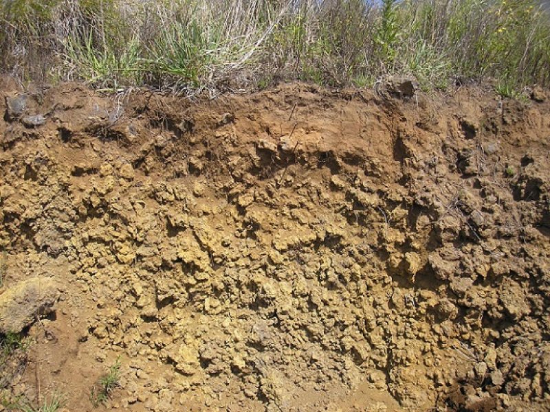
Figure 1. Kemole soil.
Table 5. Representative soil features
| Parent material |
(1)
Basaltic volcanic ash
–
basalt
|
|---|---|
| Surface texture |
(1) Medial very fine sandy loam (2) Ashy loamy fine sand |
| Family particle size |
(1) Loamy |
| Drainage class | Well drained |
| Permeability class | Moderately rapid to rapid |
| Soil depth | 102 – 203 cm |
| Surface fragment cover <=3" | 0 – 10% |
| Surface fragment cover >3" | 0 – 40% |
| Available water capacity (0-101.6cm) |
4.32 – 10.41 cm |
| Calcium carbonate equivalent (0-101.6cm) |
0% |
| Electrical conductivity (0-101.6cm) |
0 – 4 mmhos/cm |
| Sodium adsorption ratio (0-101.6cm) |
0 |
| Soil reaction (1:1 water) (0-101.6cm) |
5.4 – 7 |
| Subsurface fragment volume <=3" (Depth not specified) |
0 – 25% |
| Subsurface fragment volume >3" (Depth not specified) |
0 – 50% |
Table 6. Representative soil features (actual values)
| Drainage class | Well drained |
|---|---|
| Permeability class | Very slow to rapid |
| Soil depth | 13 – 203 cm |
| Surface fragment cover <=3" | 0 – 10% |
| Surface fragment cover >3" | 0 – 40% |
| Available water capacity (0-101.6cm) |
2.54 – 25.4 cm |
| Calcium carbonate equivalent (0-101.6cm) |
0% |
| Electrical conductivity (0-101.6cm) |
0 – 4 mmhos/cm |
| Sodium adsorption ratio (0-101.6cm) |
0 – 15 |
| Soil reaction (1:1 water) (0-101.6cm) |
5.4 – 8.6 |
| Subsurface fragment volume <=3" (Depth not specified) |
0 – 25% |
| Subsurface fragment volume >3" (Depth not specified) |
0 – 50% |
Ecological dynamics
The information in this ecological site description (ESD), including the state-and-transition model (STM), was developed using archaeological and historical data, professional experience, and scientific studies. The information is representative of a complex set of plant communities. Not all scenarios or plants are included. Key indicator plants, animals, and ecological processes are described to inform land management decisions.
States and community phases within this ecological site were differentiated by inspection of data; ordination programs were not available. They were verified by professional consensus and observations of consistent examples in the field.
This ecological site mostly occurs on soils developed in deep volcanic ash in a dry region on the western-facing slope of Mauna Kea volcano on the Island of Hawaii. Interception of wind-driven cloud water (fog drip) by trees and shrubs with subsequent throughfall of water to the ground is an important part of the total moisture supply in this ecological site, particularly during the dry summer months (Juvik and Nullet 1993).
The Reference State for this ecological site is a native dry mamane/naio forest which tends to grow in clumps interspersed with open areas vegetated by grasses and shrubs. The Reference State can transition to an Invaded Understory state through the activities of introduced ungulates which trample and consume the native understory of tree seedlings, grasses, shrubs and vines and destroys the soil micro biotic crust, ultimately opening the site to the establishment of introduced grasses and forbs. The Invaded Understory State is transitioned rapidly to a Naturalized Grassland State through mechanical clearing or by fire, or may transition more gradually as mature trees die off and their reproduction is suppressed due to browsing, trampling, competition from introduced grasses and herbs, or smothering by Cape-Ivy. The Naturalized Grassland State supports three plant community phases which (depending on management and other factors) may include 1). Good Condition Pastures, 2). Poor Condition Pastures, or 3) Weedy Pastures. Or, the Invaded Understory state may transition to a Denuded State where large numbers of introduced mouflon (Orvis orientalis orientalis) and feral sheep are present. They are capable of stripping this ecological site of nearly all vegetation if their numbers are not controlled by hunting or other animal control methods.
Natural Disturbances
There have been no lava flows or heavy volcanic ash flows on this ecological site that are recent enough to have affected the current vegetation and soils. It is possible that strong storms may sometimes cause minor windthrow of trees. Wildfires started by lightning rarely may affect this ecological site.
Human Disturbances
Human-related disturbances have been much more important than natural disturbances in this ecological site since the arrival of Polynesians and, later, Europeans. This is reflected in the State and Transition Model Diagram.
Humans arrived in the Hawaiian Islands 1200 to 1500 years ago. Their population gradually increased so that by 1600 AD at least 80% of all the lands in Hawaii below about 1500 feet (roughly 500 meters) in elevation had been extensively altered by humans (Kirch 1982); some pollen core data suggest that up to 100% of lowlands may have been altered (Athens 1997). By the time of European contact late in the 18th century, the Polynesians had developed high population densities and placed extensive areas under intensive agriculture (Cuddihy and Stone 1990).
Prehistoric native lowland forest disturbance can be attributed to clearing for agriculture by hand or by fire, introduction of new plants and animals, and wood harvesting. Higher elevation forests, such as this ecological site, would have been much less affected, but may have been affected by factors such as inadvertently introduced plant diseases and seed predation by the introduced Pacific rat (Athens 1997).
After the arrival of Europeans, documentary evidence attests to accelerated and extensive deforestation, erosion, siltation, and changes in local weather patterns (Kirch 1983) due to more intensive land use, modern tools, and introduction of more plant, animal, and microbe species.
The Polynesians introduced dogs, Pacific rats, and small pigs to the islands. Cattle, sheep, horses, goats, and larger European pigs were introduced in the final decades of the 18th century. These animals ranged free on the islands, becoming very numerous and destructive by the early decades of the 19th century. Additionally, packs of feral dogs had become established, as confirmed by reports of their depredations on sheep. By 1851, records reported severe overstocking of pastures, lack of fences, and large numbers of feral livestock (Henke 1929).
Through the 20th and into the 21st centuries, increases in human populations with attendant land development, as well as accelerated introduction of non-native mammals, birds, reptiles, amphibians, invertebrates, plants, and microorganisms, have brought about dramatic changes to wild ecosystems in Hawaii. Much of the original forest of this ecological site has been cleared and planted with introduced grasses for livestock grazing, and the remaining native plant stands have been highly disturbed.
Most of the mountain sandalwood (Santalum paniculatum) was cut from this ecological site forests and shipped to China in the early 1800s. Most of the sandalwood had been harvested by the 1840s.
By the second quarter of the 19th Century, immense herds of livestock were present in the area. A sheep ranch existed in this area, with headquarters at Humuula Station. The ranch had an area of about 50,000 acres (22,700 hectares) at an elevation ranging between 6600 and 9500 feet (2000 to 2880 hectares). Twelve thousand Merinos were kept. This is a region of heavy dews and much fog and the sheep got all their water from the vegetation. Fence posts were made from mamane and eucalyptus. It was reported in 1856 that much of the vegetation had disappeared and many areas had been cleared to bare soil. Throughout the middle and late 1800s, efforts at control of the introduced herbivores continued, but with only minimal success (Henke 1929). Currently, areas used by domestic livestock are fenced and managed for cool-season perennial grasses.
State and transition model
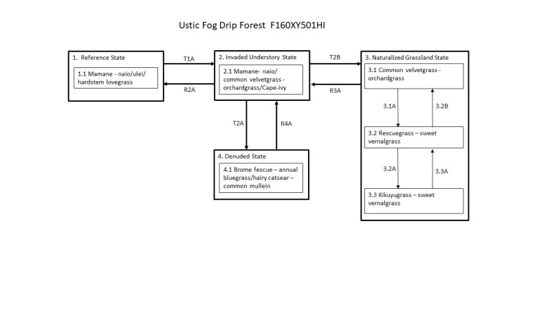
Figure 2. STM F160XY501HI
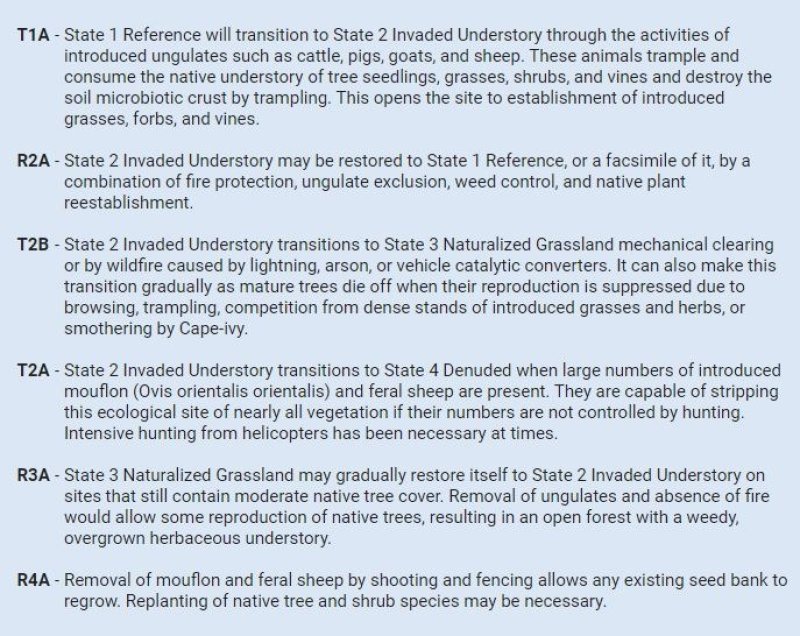
Figure 3. Transition and Pathways F160XY501HI
Figure 4. Community Pathways F160XY501HI
More interactive model formats are also available.
View Interactive Models
More interactive model formats are also available.
View Interactive Models
Click on state and transition labels to scroll to the respective text
Ecosystem states
| T1A | - | State 1 Reference will transition to State 2 Invaded Understory through the activities of introduced ungulates such as cattle, pigs, goats, and sheep. These animals trample and consume the native understory of tree seedlings, grasses, shrubs, and vines and destroy the soil microbiotic crust by trampling. This opens the site to establishment of introduced grasses, forbs, and vines. |
|---|---|---|
| R2A | - | State 2 Invaded Understory may be restored to State 1 Reference, or a facsimile of it, by a combination of fire protection, ungulate exclusion, weed control, and native plant reestablishment. |
| T2B | - | State 2 Invaded Understory transitions to State 3 Naturalized Grassland mechanical clearing or by wildfire caused by lightning, arson, or vehicle catalytic converters. It can also make this transition gradually as mature trees die off when their reproduction is suppressed due to browsing, trampling, competition from dense stands of introduced grasses and herbs, or smothering by Cape-ivy. |
| T2A | - | State 2 Invaded Understory transitions to State 4 Denuded when large numbers of introduced mouflon (Ovis orientalis orientalis) and feral sheep are present. They are capable of stripping this ecological site of nearly all vegetation if their numbers are not controlled by hunting. Intensive hunting from helicopters has been necessary at times. |
| R3A | - | State 3 Naturalized Grassland may gradually restore itself to State 2 Invaded Understory on sites that still contain moderate native tree cover. Removal of ungulates and absence of fire would allow some reproduction of native trees, resulting in an open forest with a weedy, overgrown herbaceous understory. |
| R4A | - | Removal of mouflon and feral sheep by shooting and fencing allows any existing seed bank to regrow. Replanting of native tree and shrub species may be necessary. |
State 1 submodel, plant communities
State 2 submodel, plant communities
State 3 submodel, plant communities
| 3.1A | - | Community phase 3.1 changes to community phase 3.2 by continuous grazing that weakens preferred grass species in relation to poorer forage species such as sweet vernal grass. Fireweed or Madagascar ragwort (Senecio madagascariensis) and narrowleaf plantain (Plantago lanceolata) also increase under these conditions. |
|---|---|---|
| 3.2B | - | Community phase 3.2 changes to phase 3.1 by prescribed grazing and weed control. A prescribed grazing plan provides for intensive but temporary grazing of pastures that ensures that cattle consume some low-value forage species along with preferred forages and allows preferred forages time to recover from defoliation and reproduce by seed. The grazing plan may require splitting the herd, creating additional water sources, and creating multiple pastures by cross-fencing. Fireweed is very difficult to control in this ecological site by prescribed grazing alone, and will require some weed control measures to reduce its abundance to acceptable levels. |
| 3.2A | - | Community phase 3.2 changes to phase 3.3 by long-term continuous grazing. Desirable forage grasses are much reduced in size, vigor, and abundance and are replaced in large part by low-value forage grasses and weedy forbs. |
| 3.3A | - | Community phase 3.3 changes to phase 3.2 by prescribed grazing and extensive weed control. Replanting of desirable forage species also is necessary. The grazing prescription will require removal of livestock from the site until seeded forage species have reestablished adequately to withstand grazing. Thereafter, the grazing plan may require splitting the herd, creating additional water sources, and creating multiple pastures by cross-fencing. |
State 4 submodel, plant communities
State 1
Reference State
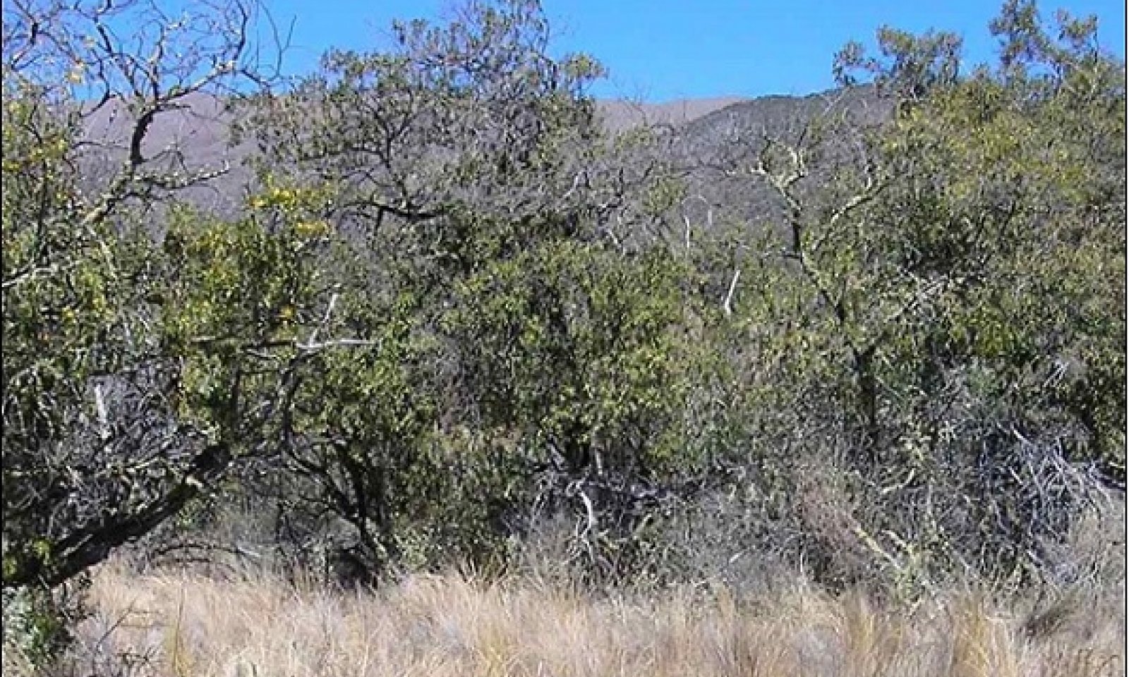
This state consists of one community phase. Tree cover is somewhat clumped. Open areas between clumps are dominated by bunchgrasses or shrub thickets. These forests have standing live timber of 100 to 400 cubic feet per acre, with a representative value of about 300 cubic feet per acre; these estimates may be conservative. Few mountain sandalwood trees remain due to extensive harvesting in the early 19th century. Akoko or alpine sandmat (Chamaesyce olowaluana) and mountain pilo or alpine mirrorplant (Coprosma montana) trees are browsed heavily by ungulates. It is likely that their former size and abundance are greatly underestimated in our data. Long-term vegetation plots in this ecological site that are securely fenced against ungulates contain much more abundant and diverse native vegetation, and going to higher elevations, than outside the plots.
Community 1.1
Mamane - naio/ulei/hardstem lovegrass

Figure 5. Reference community phase 1/26/07 D Clausnitzer MU804
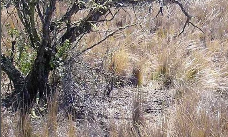
Figure 6. Native grass understory. 1/26/07 D Clausnitzer MU804
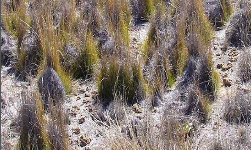
Figure 7. Closeup of grass cover. 1/26/07 D Clausnitzer MU804
Figure 8. Microbiotic crust on soil surface. 5/15/08 D Clausnitzer generic photo
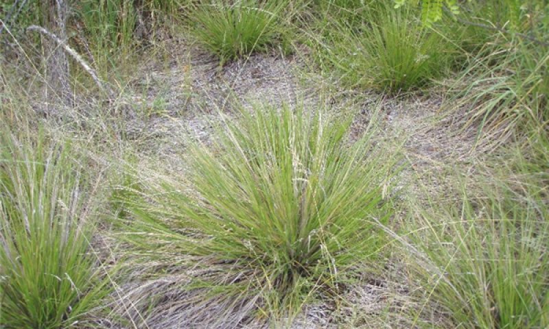
Figure 9. Native hardstem lovegrass. 5/15/08 D Clausnitzer g
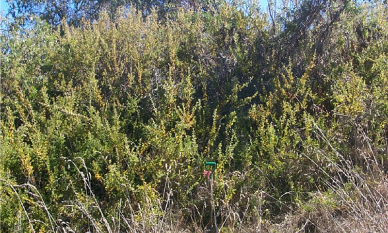
Figure 10. Large ulei shrub. 1/26/07 D Clausnitzer MU804
The general aspect is a forest with a short to medium (15 to 40 feet or 4.5 to 10 meters) stature overstory in dense clumps on the landscape. Open areas are dominated by native perennial cool-season grasses. Ulei or Hawaii hawthorn (Osteomeles anthyllidifolia) forms dense thickets up to 30 feet (13.5 meters) in diameter and 10 feet (3 meters) tall. Soil surfaces in interspaces between grass clumps are covered with a microbiotic crust of lichens and mosses. The overstory consists mostly of mamane (Sophora chrysophylla) and naio (Myoporum sandwicense). Akoko or alpine sandmat (Chamaesyce olowaluana) and mountain pilo or alpine mirrorplant (Coprosma montana) are common, and mountain sandalwood (Santalum paniculatum) is present but widely dispersed; it is likely that their relative abundances were greater in the past. The understory within tree clumps consists of a mix of hardstem lovegrass (Eragrostis atropioides) and pili uka (Trisetum glomeratum), the forb kookoolau or viper beggarticks (Bidens campylotheca), the fern black spleenwort (Asplenium adiantum-nigrum), the shrubs Mauna Loa beggarticks (Bidens menziesii) and ulei or Hawaii hawthorn (Osteomeles anthyllidifolium), and the vines anunu or alpine bur cucumber (Sicyos macrophyllus), lava bur cucumber (Sicyos anunu) and littleleaf stenogyne (Stenogyne microphylla). Open areas are dominated by the bunchgrasses noted above. Ulei occurs mostly in thickets; the other species are widely dispersed among the grasses. Also common and dispersed in the open areas are the shrubs aweoweo or alaweo (Chenopodium oahuense), aalii or Florida hopbush (Dodonaea viscosa), and yellow ilima (Sida fallax).
Forest overstory. The overstory consists mostly of mamane (Sophora chrysophylla) and naio (Myoporum sandwicense). Akoko or alpine sandmat (Chamaesyce olowaluana) and mountain pilo or alpine mirrorplant (Coprosma montana) are common, and mountain sandalwood (Santalum paniculatum) is present but widely dispersed; it is likely that their relative abundances were greater in the past.
Forest understory. The understory within tree clumps consists of a mix of hardstem lovegrass (Eragrostis atropioides) and pili uka (Trisetum glomeratum), the forb kookoolau or viper beggarticks (Bidens campylotheca), the fern black spleenwort (Asplenium adiantum-nigrum), the shrubs Mauna Loa beggarticks (Bidens menziesii) and ulei or Hawaii hawthorn (Osteomeles anthyllidifolium), and the vines anunu or alpine bur cucumber (Sicyos macrophyllus), lava bur cucumber (Sicyos anunu) and littleleaf stenogyne (Stenogyne microphylla).
Open areas are dominated by the bunchgrasses noted above. Ulei occurs mostly in thickets; the other species are widely dispersed among the grasses. Also common and dispersed in the open areas are the shrubs aweoweo or alaweo (Chenopodium oahuense), aalii or Florida hopbush (Dodonaea viscosa), and yellow ilima (Sida fallax).
Dominant plant species
-
mamani (Sophora chrysophylla), tree
-
naio (Myoporum sandwicense), tree
-
Hawai'i hawthorn (Osteomeles anthyllidifolia), shrub
-
hardstem lovegrass (Eragrostis atropioides), grass
Table 7. Soil surface cover
| Tree basal cover | 1-2% |
|---|---|
| Shrub/vine/liana basal cover | 0.5-1.0% |
| Grass/grasslike basal cover | 2-4% |
| Forb basal cover | 0.5-1.0% |
| Non-vascular plants | 1-5% |
| Biological crusts | 15-20% |
| Litter | 40-50% |
| Surface fragments >0.25" and <=3" | 0.1-1.0% |
| Surface fragments >3" | 0.1-1.0% |
| Bedrock | 0% |
| Water | 0% |
| Bare ground | 1-2% |
Table 8. Woody ground cover
| Downed wood, fine-small (<0.40" diameter; 1-hour fuels) | – |
|---|---|
| Downed wood, fine-medium (0.40-0.99" diameter; 10-hour fuels) | – |
| Downed wood, fine-large (1.00-2.99" diameter; 100-hour fuels) | – |
| Downed wood, coarse-small (3.00-8.99" diameter; 1,000-hour fuels) | 0-0% |
| Downed wood, coarse-large (>9.00" diameter; 10,000-hour fuels) | – |
| Tree snags** (hard***) | – |
| Tree snags** (soft***) | – |
| Tree snag count** (hard***) | 2-5 per hectare |
| Tree snag count** (hard***) | 2-5 per hectare |
* Decomposition Classes: N - no or little integration with the soil surface; I - partial to nearly full integration with the soil surface.
** >10.16cm diameter at 1.3716m above ground and >1.8288m height--if less diameter OR height use applicable down wood type; for pinyon and juniper, use 0.3048m above ground.
*** Hard - tree is dead with most or all of bark intact; Soft - most of bark has sloughed off.
Table 9. Canopy structure (% cover)
| Height Above Ground (m) | Tree | Shrub/Vine | Grass/ Grasslike |
Forb |
|---|---|---|---|---|
| <0.15 | 0% | 0% | 1-2% | 1-2% |
| >0.15 <= 0.3 | 0% | 0% | 2-5% | 1-2% |
| >0.3 <= 0.6 | 0-1% | 1-1% | 15-25% | 1-2% |
| >0.6 <= 1.4 | 1-1% | 5-10% | – | – |
| >1.4 <= 4 | 15-25% | 5-10% | – | – |
| >4 <= 12 | 25-35% | 1-1% | – | – |
| >12 <= 24 | – | – | – | – |
| >24 <= 37 | – | – | – | – |
| >37 | – | – | – | – |
State 2
Invaded Understory State
This state is comprised of one community phase. Most native bunchgrasses, vines, shrubs, tree seedlings and saplings, and microbiotic crusts have been destroyed by ungulates and by competition from introduced plant species. They have been replaced by a dense cover of introduced grasses and forbs and patches of bare soil. Tree abundance is still high but lower than in the Reference State because tree reproduction has been impeded for many years. Native tree diversity is lower than in the Reference State. With ungulate exclusion and weed control, this state can be restored to State 1 Reference State. With continued managed livestock grazing and protection from feral ungulates, it will gradually transition to State 3 Naturalized Grassland. With exposure to large numbers of feral ungulates, it will transition to State 4 Denuded.
Community 2.1
Mamane - naio/common velvetgrass - orchardgrass/Cape-ivy
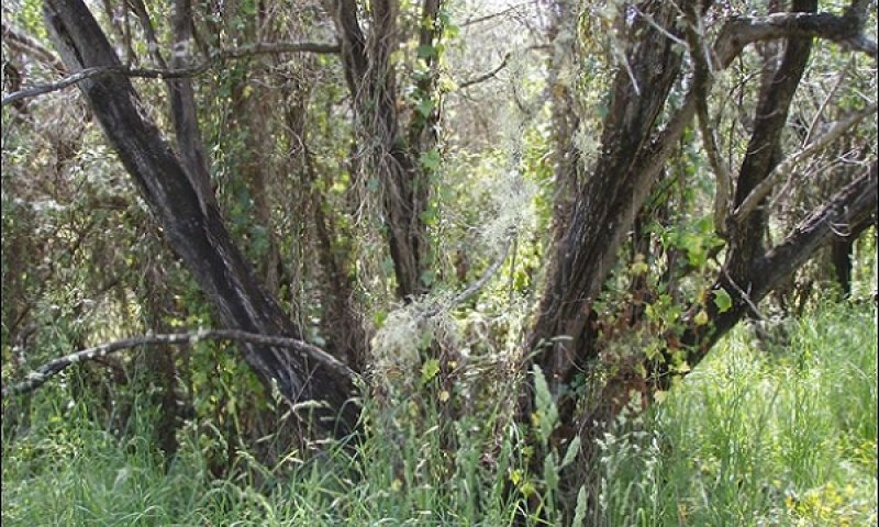
Figure 11. Introduced grasses and Cape-ivy understory. 5/15/08 D Clausnitzer generic photo
Figure 12. Introduced grasses and forbs. 5/15/08 D Clausnitzer generic photo
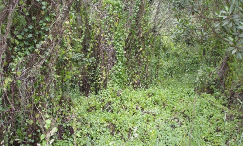
Figure 13. Heavy Cape-ivy infestation. 5/15/08 D Clausnitzer generic photo
Cape-ivy (Delairia odorata), an introduced climbing vine, is abundant. Kentucky bluegrass (Poa pratensis), an introduced forage grass typically found in moist pastures on the mainland, forms a dense cover under the canopies and near the trunks of many trees where it benefits from fog interception and throughfall from the trees. Introduced cool-season (C3) forage grasses dominate the understory.
Forest overstory. The overstory consists mostly of mamane (Sophora chrysophylla) and naio (Myoporum sandwicense); akoko or alpine sandmat (Chamaesyce olowaluana) is also present. Mountain pilo or alpine mirrorplant (Coprosma montana) and mountain sandalwood (Santalum paniculatum) may be present but are rare. Many trees carry a burden of climbing Cape-ivy.
Forest understory. The dominant grasses are introduced cool-season species of good forage quality. Common velvet grass (Holcus lanatus) is most abundant, followed by orchardgrass (Dactylis glomerata) and Kentucky bluegrass (Poa pratensis). Small amounts of introduced warm-season kikuyugrass (Pennisetum clandestinum) and native cool-season hardstem lovegrass (Eragrostis atropioides) and pili uka (Trisetum glomeratum) are usually present. Seedlings and saplings of native tree species are present but not abundant.
Dominant plant species
-
mamani (Sophora chrysophylla), tree
-
naio (Myoporum sandwicense), tree
-
common velvetgrass (Holcus lanatus), grass
-
orchardgrass (Dactylis glomerata), grass
-
Cape-ivy (Delairea odorata), other herbaceous
Table 10. Soil surface cover
| Tree basal cover | 1-2% |
|---|---|
| Shrub/vine/liana basal cover | 0.0-0.1% |
| Grass/grasslike basal cover | 25-35% |
| Forb basal cover | 0.1-0.5% |
| Non-vascular plants | 0.1-1.0% |
| Biological crusts | 0.1-1.0% |
| Litter | 55-65% |
| Surface fragments >0.25" and <=3" | 0.1-1.0% |
| Surface fragments >3" | 0.1-1.0% |
| Bedrock | 0% |
| Water | 0% |
| Bare ground | 5-10% |
Table 11. Woody ground cover
| Downed wood, fine-small (<0.40" diameter; 1-hour fuels) | – |
|---|---|
| Downed wood, fine-medium (0.40-0.99" diameter; 10-hour fuels) | – |
| Downed wood, fine-large (1.00-2.99" diameter; 100-hour fuels) | – |
| Downed wood, coarse-small (3.00-8.99" diameter; 1,000-hour fuels) | 0-1% |
| Downed wood, coarse-large (>9.00" diameter; 10,000-hour fuels) | – |
| Tree snags** (hard***) | – |
| Tree snags** (soft***) | – |
| Tree snag count** (hard***) | 2-5 per hectare |
| Tree snag count** (hard***) | 5-10 per hectare |
* Decomposition Classes: N - no or little integration with the soil surface; I - partial to nearly full integration with the soil surface.
** >10.16cm diameter at 1.3716m above ground and >1.8288m height--if less diameter OR height use applicable down wood type; for pinyon and juniper, use 0.3048m above ground.
*** Hard - tree is dead with most or all of bark intact; Soft - most of bark has sloughed off.
Table 12. Canopy structure (% cover)
| Height Above Ground (m) | Tree | Shrub/Vine | Grass/ Grasslike |
Forb |
|---|---|---|---|---|
| <0.15 | 0% | 0-1% | 1-5% | 1-2% |
| >0.15 <= 0.3 | 0% | 2-3% | 1-5% | 3-5% |
| >0.3 <= 0.6 | 0% | 2-3% | 30-40% | 10-15% |
| >0.6 <= 1.4 | 3-5% | 3-5% | 1-2% | 1-2% |
| >1.4 <= 4 | 25-35% | 1-2% | – | – |
| >4 <= 12 | – | – | – | – |
| >12 <= 24 | – | – | – | – |
| >24 <= 37 | – | – | – | – |
| >37 | – | – | – | – |
State 3
Naturalized Grassland State
This state is comprised of three community phases. An open canopy of remnant native trees may be present. Reduced or absent tree cover results in stronger surface winds, more intense solar radiation reaching the soil surface, and reduced or nonexistent fog interception and throughfall. Introduced, perennial, cool-season (C3) grass species with high forage value dominate this state under good grazing management. Continuous grazing that does not allow the favored forage species time to recover from defoliation or to reproduce from seed results in shifting to phases that contain increased abundance of cool-season perennial grass species of lower value forage value, annual grasses, and weedy forbs. Still heavier grazing pressure and summer grazing results in an increase of kikuyugrass (Pennisetum clandestinum) cover, which is more tolerant of heavy defoliation and loss of reproductive parts than cool-season bunchgrasses such as common velvetgrass (Holcus lanatus) and orchardgrass (Dactylis glomerata). Kikuyugrass is a desired forage species in some other ecological sites. However, in this ecological site this warm-season (C4) species does not grow particularly well. At lower elevations of this ecological site, kikuyugrass can be a fair forage, particularly during extended dry climate cycles that inhibit growth of other forages. At higher elevations, kikuyugrass increases in cover but has low vigor. Application of prescribed grazing and weed control measures can the condition of community phases that have been degraded. In some cases, reseeding of desired cool-season grasses may be worthwhile.
Community 3.1
Common velvetgrass - orchardgrass
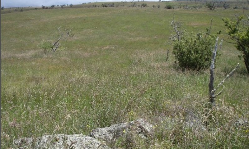
Figure 14. Cool-season grasses. 11-07 D Clausnitzer generic photo
The large cool-season grasses that dominate this community phase provide good forage quality and relatively stable production due to their perennial habit.
Forest overstory. Scattered to moderately abundant mamane (Sophora chrysophylla) and naio (Myoporum sandwicense) trees may be present; often there are standing dead trees, also. Few to no seedling or saplings are present.
Forest understory. The dominant grass species in this community phase is common velvetgrass (Holcus lanatus), usually with an admixture of orchardgrass (Dactylis glomerata). Small amounts of other grass species and weedy forbs are present, as is some rabbitfoot clover (Trifolium arvense).
Dominant plant species
-
common velvetgrass (Holcus lanatus), grass
-
orchardgrass (Dactylis glomerata), grass
Figure 15. Annual production by plant type (representative values) or group (midpoint values)
Community 3.2
Rescuegrass - sweet vernalgrass
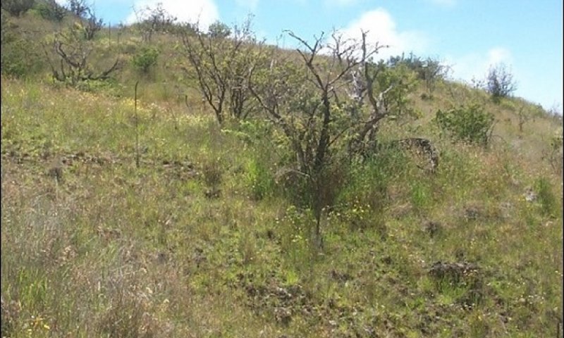
Figure 16. Fescue and vernalgrass with remnant native trees. 11/07 D Clausnitzer generic photo
This community phase is dominated by introduced, cool-season perennial grasses of lower forage value and introduced annual grasses. Weedy forbs have also increased.
Forest overstory. Scattered to moderately abundant mamane (Sophora chrysophylla) and naio (Myoporum sandwicense) trees may be present; often there are standing dead trees, also.
Forest understory. The most abundant grass species is sweet vernal grass (Anthoxanthum odoratum). Common velvetgrass is no longer dominant and is roughly equaled in abundance by rescuegrass (Bromus catharticus), an introduced annual or short-lived perennial grass. Weedy forbs such as fireweed and narrowleaf plantain have increased in abundance.
Dominant plant species
-
rescuegrass (Bromus catharticus), grass
-
sweet vernalgrass (Anthoxanthum odoratum), grass
Table 13. Soil surface cover
| Tree basal cover | 0.0-0.1% |
|---|---|
| Shrub/vine/liana basal cover | 0.0-0.1% |
| Grass/grasslike basal cover | 15-25% |
| Forb basal cover | 2-3% |
| Non-vascular plants | 0.1-1.0% |
| Biological crusts | 0.1-1.0% |
| Litter | 50-60% |
| Surface fragments >0.25" and <=3" | 0.5-1.0% |
| Surface fragments >3" | 0.5-1.0% |
| Bedrock | 0% |
| Water | 0% |
| Bare ground | 5-10% |
Table 14. Woody ground cover
| Downed wood, fine-small (<0.40" diameter; 1-hour fuels) | – |
|---|---|
| Downed wood, fine-medium (0.40-0.99" diameter; 10-hour fuels) | – |
| Downed wood, fine-large (1.00-2.99" diameter; 100-hour fuels) | – |
| Downed wood, coarse-small (3.00-8.99" diameter; 1,000-hour fuels) | 0-0% |
| Downed wood, coarse-large (>9.00" diameter; 10,000-hour fuels) | – |
| Tree snags** (hard***) | – |
| Tree snags** (soft***) | – |
| Tree snag count** (hard***) | 2-5 per hectare |
| Tree snag count** (hard***) | 7-10 per hectare |
* Decomposition Classes: N - no or little integration with the soil surface; I - partial to nearly full integration with the soil surface.
** >10.16cm diameter at 1.3716m above ground and >1.8288m height--if less diameter OR height use applicable down wood type; for pinyon and juniper, use 0.3048m above ground.
*** Hard - tree is dead with most or all of bark intact; Soft - most of bark has sloughed off.
Table 15. Canopy structure (% cover)
| Height Above Ground (m) | Tree | Shrub/Vine | Grass/ Grasslike |
Forb |
|---|---|---|---|---|
| <0.15 | – | 0% | 1-2% | 3-5% |
| >0.15 <= 0.3 | – | 1-2% | 3-5% | 5-10% |
| >0.3 <= 0.6 | – | 1-2% | 75-85% | 15-20% |
| >0.6 <= 1.4 | – | 1-1% | 1-2% | 1-2% |
| >1.4 <= 4 | 1-2% | – | – | – |
| >4 <= 12 | 1-2% | – | – | – |
| >12 <= 24 | – | – | – | – |
| >24 <= 37 | – | – | – | – |
| >37 | – | – | – | – |
Community 3.3
Kikuyugrass - sweet vernalgrass
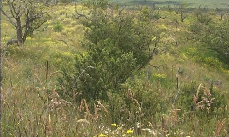
Figure 17. Grassland with weedy forbs and remnant native trees. 11/07 D Clausnitzer generic photo
This community phase is dominated by low-value forage species. Low-vigor kikuyugrass, a warm-season grass species, has increased in abundance due to reduced competition by tall cool-season grasses and by its relative ability to withstand heavy grazing. Weedy forbs are very abundant.
Forest overstory. Scattered to moderately abundant mamane (Sophora chrysophylla) and naio (Myoporum sandwicense) trees may be present; often there are standing dead trees, also.
Forest understory. Sweet vernalgrass is the most abundant grass species; common velvetgrass has declined to be a minor part of the grass cover. Weedy forbs such as fireweed or Madagascar ragwort and narrowleaf plantain are very abundant.
Dominant plant species
-
kikuyugrass (Pennisetum clandestinum), grass
-
sweet vernalgrass (Anthoxanthum odoratum), grass
Table 16. Soil surface cover
| Tree basal cover | 0.0-0.1% |
|---|---|
| Shrub/vine/liana basal cover | 0.0-0.1% |
| Grass/grasslike basal cover | 20-30% |
| Forb basal cover | 2-3% |
| Non-vascular plants | 0.1-1.0% |
| Biological crusts | 0.1-1.0% |
| Litter | 60-70% |
| Surface fragments >0.25" and <=3" | 0.1-1.0% |
| Surface fragments >3" | 0.1-1.0% |
| Bedrock | 0% |
| Water | 0% |
| Bare ground | 5-10% |
Table 17. Woody ground cover
| Downed wood, fine-small (<0.40" diameter; 1-hour fuels) | – |
|---|---|
| Downed wood, fine-medium (0.40-0.99" diameter; 10-hour fuels) | – |
| Downed wood, fine-large (1.00-2.99" diameter; 100-hour fuels) | – |
| Downed wood, coarse-small (3.00-8.99" diameter; 1,000-hour fuels) | 0-0% |
| Downed wood, coarse-large (>9.00" diameter; 10,000-hour fuels) | – |
| Tree snags** (hard***) | – |
| Tree snags** (soft***) | – |
| Tree snag count** (hard***) | 0-2 per hectare |
| Tree snag count** (hard***) | 2-5 per hectare |
* Decomposition Classes: N - no or little integration with the soil surface; I - partial to nearly full integration with the soil surface.
** >10.16cm diameter at 1.3716m above ground and >1.8288m height--if less diameter OR height use applicable down wood type; for pinyon and juniper, use 0.3048m above ground.
*** Hard - tree is dead with most or all of bark intact; Soft - most of bark has sloughed off.
Table 18. Canopy structure (% cover)
| Height Above Ground (m) | Tree | Shrub/Vine | Grass/ Grasslike |
Forb |
|---|---|---|---|---|
| <0.15 | – | 0% | 1-2% | 1-5% |
| >0.15 <= 0.3 | – | 0-1% | 3-5% | 5-10% |
| >0.3 <= 0.6 | 0% | 1-2% | 60-65% | 25-30% |
| >0.6 <= 1.4 | 0% | 1-2% | 1-2% | 1-2% |
| >1.4 <= 4 | 1-1% | – | – | – |
| >4 <= 12 | 1-1% | – | – | – |
| >12 <= 24 | – | – | – | – |
| >24 <= 37 | – | – | – | – |
| >37 | – | – | – | – |
Pathway 3.1A
Community 3.1 to 3.2
Community phase 3.1 changes to community phase 3.2 by continuous grazing that weakens preferred grass species in relation to poorer forage species such as sweet vernal grass. Fireweed or Madagascar ragwort (Senecio madagascariensis) and narrowleaf plantain (Plantago lanceolata) also increase under these conditions.
Pathway 3.2B
Community 3.2 to 3.1
Community phase 3.2 changes to phase 3.1 by prescribed grazing and weed control. A prescribed grazing plan provides for intensive but temporary grazing of pastures that ensures that cattle consume some low-value forage species along with preferred forages and allows preferred forages time to recover from defoliation and reproduce by seed. The grazing plan may require splitting the herd, creating additional water sources, and creating multiple pastures by cross-fencing. Fireweed is very difficult to control in this ecological site by prescribed grazing alone, and will require some weed control measures to reduce its abundance to acceptable levels.
Pathway 3.2A
Community 3.2 to 3.3
Community phase 3.2 changes to phase 3.3 by long-term continuous grazing. Desirable forage grasses are much reduced in size, vigor, and abundance and are replaced in large part by low-value forage grasses and weedy forbs.
Pathway 3.3A
Community 3.3 to 3.2
Community phase 3.3 changes to phase 3.2 by prescribed grazing and extensive weed control. Replanting of desirable forage species also is necessary. The grazing prescription will require removal of livestock from the site until seeded forage species have reestablished adequately to withstand grazing. Thereafter, the grazing plan may require splitting the herd, creating additional water sources, and creating multiple pastures by cross-fencing.
State 4
Denuded State
This state consists of one community phase. It results from long-term grazing and browsing by feral and mouflon sheep. Mouflon were introduced on Mauna Kea in the 1960s as a game animal and increased rapidly in numbers. Uncontrolled destruction of vegetation resulted in large areas of higher elevations of Mauna Kea becoming nearly devoid of vegetation. Intensive control of these animals allowed recovery of the vegetation over a period of 30 to 40 years in areas where a sufficient seed bank still existed in the soil. Some areas were actively replanted with native species.
Community 4.1
Brome fescue - annual bluegrass/hairy catsear - common mullein
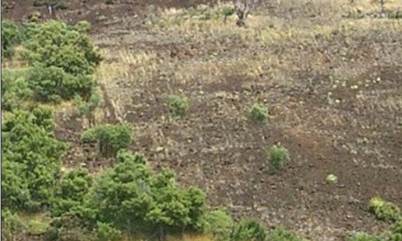
Figure 18. Denuded state showing fenceline contrast. 11/07 D Clausnitzer generic photo
The vegetation community phase has total percent canopy cover as low as single digits; most of the soil surface is bare. Small amounts of litter are present, and surface rocks are common. Most of the vegetation consists of introduced annual grasses and forbs. Scattered native trees may be present, as are dead standing trees.
Forest overstory. A few live mamane and naio trees may be present.
Forest understory. The introduced annual grasses brome fescue (Vulpia bromoides) and annual bluegrass (Poa annua) are present, as is the introduced perennial sweet vernalgrass (Anthoxanthum odoratum). Forbs consist of fireweed or Madagascar ragweed (Senecio madagascariensis), stinking strawflower (Helichrysum foetida), common mullein (Verbascum thapsus), and hairy catsear (Hypochaeris radicata).
Dominant plant species
-
brome fescue (Vulpia bromoides), grass
-
annual bluegrass (Poa annua), grass
Table 19. Soil surface cover
| Tree basal cover | 0% |
|---|---|
| Shrub/vine/liana basal cover | 0% |
| Grass/grasslike basal cover | 1-2% |
| Forb basal cover | 0.5-1.0% |
| Non-vascular plants | 0-1% |
| Biological crusts | 0-1% |
| Litter | 1-5% |
| Surface fragments >0.25" and <=3" | 3-5% |
| Surface fragments >3" | 3-5% |
| Bedrock | 0% |
| Water | 0% |
| Bare ground | 80-85% |
Table 20. Canopy structure (% cover)
| Height Above Ground (m) | Tree | Shrub/Vine | Grass/ Grasslike |
Forb |
|---|---|---|---|---|
| <0.15 | – | – | 0-1% | 0-1% |
| >0.15 <= 0.3 | – | – | 1-1% | 0-1% |
| >0.3 <= 0.6 | – | – | 0-1% | 1-1% |
| >0.6 <= 1.4 | – | – | – | 0-1% |
| >1.4 <= 4 | – | – | – | – |
| >4 <= 12 | – | – | – | – |
| >12 <= 24 | – | – | – | – |
| >24 <= 37 | – | – | – | – |
| >37 | – | – | – | – |
Transition T1A
State 1 to 2
State 1 Reference will transition to State 2 Invaded Understory through the activities of introduced ungulates such as cattle, pigs, goats, and sheep. These animals trample and consume the native understory of tree seedlings, grasses, shrubs, and vines and destroy the soil microbiotic crust by trampling. This opens the site to establishment of introduced grasses, forbs, and vines.
Restoration pathway R2A
State 2 to 1
State 2 Invaded Understory may be restored to State 1 Reference, or a facsimile of it, by a combination of fire protection, ungulate exclusion, weed control, and native plant reestablishment.
Transition T2B
State 2 to 3
State 2 Invaded Understory transitions to State 3 Naturalized Grassland mechanical clearing or by wildfire caused by lightning, arson, or vehicle catalytic converters. It can also make this transition gradually as mature trees die off when their reproduction is suppressed due to browsing, trampling, competition from dense stands of introduced grasses and herbs, or smothering by Cape-ivy.
Transition T2A
State 2 to 4
State 2 Invaded Understory transitions to State 4 Denuded when large numbers of introduced mouflon (Ovis orientalis orientalis) and feral sheep are present. They are capable of stripping this ecological site of nearly all vegetation if their numbers are not controlled by hunting. Intensive hunting from helicopters has been necessary at times.
Restoration pathway R3A
State 3 to 2
State 3 Naturalized Grassland may gradually restore itself to State 2 Invaded Understory on sites that still contain moderate native tree cover. Removal of ungulates and absence of fire would allow some reproduction of native trees, resulting in an open forest with a weedy, overgrown herbaceous understory.
Restoration pathway R4A
State 4 to 2
Removal of mouflon and feral sheep by shooting and fencing allows any existing seed bank to regrow. Replanting of native tree and shrub species may be necessary.
Additional community tables
Table 21. Community 1.1 forest overstory composition
| Common name | Symbol | Scientific name | Nativity | Height (m) | Canopy cover (%) | Diameter (cm) | Basal area (square m/hectare) |
|---|---|---|---|---|---|---|---|
|
Tree
|
|||||||
| naio | MYSA | Myoporum sandwicense | Native | 4–9.1 | 10–25 | 15.2–25.4 | – |
| mamani | SOCH | Sophora chrysophylla | Native | 4–7.6 | 15–25 | – | – |
| alpine sandmat | CHOL3 | Chamaesyce olowaluana | Native | 4–7.6 | 1–3 | – | – |
| alpine mirrorplant | COMO3 | Coprosma montana | Native | 4–9.1 | 1–2 | – | – |
| mountain sandalwood | SAPA7 | Santalum paniculatum | Native | 4–12.2 | 0–1 | – | – |
Table 22. Community 1.1 forest understory composition
| Common name | Symbol | Scientific name | Nativity | Height (m) | Canopy cover (%) | |
|---|---|---|---|---|---|---|
|
Grass/grass-like (Graminoids)
|
||||||
| hardstem lovegrass | ERAT | Eragrostis atropioides | Native | 0.3–0.6 | 15–25 | |
| pili uka | TRGL3 | Trisetum glomeratum | Native | 0.3–0.6 | 3–5 | |
|
Forb/Herb
|
||||||
| viper beggarticks | BICA2 | Bidens campylotheca | Native | 0.3–0.6 | 1–2 | |
|
Fern/fern ally
|
||||||
| black spleenwort | ASAD | Asplenium adiantum-nigrum | Native | 0.2–0.3 | 0.1–1 | |
|
Shrub/Subshrub
|
||||||
| Hawai'i hawthorn | OSAN | Osteomeles anthyllidifolia | Native | 0.3–3 | 5–10 | |
| Mauna Loa beggarticks | BIME | Bidens menziesii | Native | 0.6–2.4 | 1–3 | |
| yellow ‘ilima | SIFA | Sida fallax | Native | 0.3–1.5 | 1–2 | |
| alaweo | CHOA | Chenopodium oahuense | Native | 0.3–2.4 | 1–2 | |
| Florida hopbush | DOVI | Dodonaea viscosa | Native | 0.6–3 | 1–2 | |
|
Tree
|
||||||
| naio | MYSA | Myoporum sandwicense | Native | 0.6–4 | 5–15 | |
| mamani | SOCH | Sophora chrysophylla | Native | 0.6–4 | 3–5 | |
| alpine sandmat | CHOL3 | Chamaesyce olowaluana | Native | 0.6–4 | 3–5 | |
| alpine mirrorplant | COMO3 | Coprosma montana | Native | 0.6–4 | 3–5 | |
| mountain sandalwood | SAPA7 | Santalum paniculatum | Native | 0.6–4 | – | |
|
Vine/Liana
|
||||||
| lava bur cucumber | SIAN4 | Sicyos anunu | Native | 0.3–3 | 1–2 | |
| littleleaf stenogyne | STMI3 | Stenogyne microphylla | Native | 0.3–1.5 | 0.5–1 | |
| alpine bur cucumber | SIMA6 | Sicyos macrophyllus | Native | 0.3–0.6 | 0–0.1 | |
Table 23. Community 2.1 forest overstory composition
| Common name | Symbol | Scientific name | Nativity | Height (m) | Canopy cover (%) | Diameter (cm) | Basal area (square m/hectare) |
|---|---|---|---|---|---|---|---|
|
Tree
|
|||||||
| naio | MYSA | Myoporum sandwicense | Native | 4–9.1 | 15–25 | – | – |
| mamani | SOCH | Sophora chrysophylla | Native | 4–7.6 | 5–15 | – | – |
| alpine sandmat | CHOL3 | Chamaesyce olowaluana | Native | 4–6.1 | 1–2 | – | – |
Table 24. Community 2.1 forest understory composition
| Common name | Symbol | Scientific name | Nativity | Height (m) | Canopy cover (%) | |
|---|---|---|---|---|---|---|
|
Grass/grass-like (Graminoids)
|
||||||
| common velvetgrass | HOLA | Holcus lanatus | Introduced | 0.3–0.6 | 35–45 | |
| orchardgrass | DAGL | Dactylis glomerata | Introduced | 0.3–0.6 | 10–15 | |
| Kentucky bluegrass | POPR | Poa pratensis | Introduced | 0.6–0.9 | 3–5 | |
| sweet vernalgrass | ANOD | Anthoxanthum odoratum | Introduced | 0.3–0.6 | 3–5 | |
| annual bluegrass | POAN | Poa annua | Introduced | 0.2–0.3 | 1–2 | |
| kikuyugrass | PECL2 | Pennisetum clandestinum | Introduced | 0.2–0.3 | 1–2 | |
| hardstem lovegrass | ERAT | Eragrostis atropioides | Introduced | 0.6–0.9 | 1–2 | |
| pili uka | TRGL3 | Trisetum glomeratum | Native | 0.3–0.6 | 1–2 | |
| rescuegrass | BRCA6 | Bromus catharticus | Introduced | 0.6–0.9 | 1–2 | |
|
Forb/Herb
|
||||||
| Madagascar ragwort | SEMA15 | Senecio madagascariensis | Introduced | 0.2–0.3 | 5–15 | |
| common mullein | VETH | Verbascum thapsus | Introduced | 0.6–1.2 | 0.5–2 | |
| narrowleaf plantain | PLLA | Plantago lanceolata | Introduced | 0.1–0.2 | 0.5–1 | |
| stinking strawflower | HEFO4 | Helichrysum foetidum | Introduced | 0.3–0.6 | 0.5–1 | |
| hairy cat's ear | HYRA3 | Hypochaeris radicata | Introduced | 0.2–0.3 | 0.5–1 | |
| Chilean evening primrose | OEST | Oenothera stricta | Introduced | 0.2–0.3 | 0.5–1 | |
| bull thistle | CIVU | Cirsium vulgare | Introduced | 0.6–0.9 | 0–0.1 | |
|
Shrub/Subshrub
|
||||||
| Florida hopbush | DOVI | Dodonaea viscosa | Native | 0.6–1.8 | 1–2 | |
| alaweo | CHOA | Chenopodium oahuense | Native | 0.6–1.2 | 1–2 | |
| Hawai'i hawthorn | OSAN | Osteomeles anthyllidifolia | Native | 0.6–1.8 | 1–2 | |
| yellow ‘ilima | SIFA | Sida fallax | Native | 0.6–1.2 | 0.5–1 | |
|
Tree
|
||||||
| naio | MYSA | Myoporum sandwicense | Native | 0.6–4 | 3–5 | |
| mamani | SOCH | Sophora chrysophylla | Native | 0.6–4 | 1–2 | |
| alpine sandmat | CHOL3 | Chamaesyce olowaluana | Native | 0.6–4 | 0.5–1 | |
| alpine mirrorplant | COMO3 | Coprosma montana | Native | 0.6–4 | 0.5–1 | |
|
Vine/Liana
|
||||||
| Cape-ivy | DEOD | Delairea odorata | Introduced | 0.2–0.3 | 5–10 | |
Table 25. Community 3.1 plant community composition
| Group | Common name | Symbol | Scientific name | Annual production (kg/hectare) | Foliar cover (%) | |
|---|---|---|---|---|---|---|
|
Grass/Grasslike
|
||||||
| 1 | Naturalized Warm Season Grasses | 0–140 | ||||
| kikuyugrass | PECL2 | Pennisetum clandestinum | 0–140 | – | ||
| smut grass | SPIN4 | Sporobolus indicus | 0–28 | – | ||
| 2 | Naturalized Cool Season Grasses | 3587–4259 | ||||
| common velvetgrass | HOLA | Holcus lanatus | 3587–4259 | – | ||
| sweet vernalgrass | ANOD | Anthoxanthum odoratum | 0–140 | – | ||
| orchardgrass | DAGL | Dactylis glomerata | 0–140 | – | ||
| tufted lovegrass | ERPE | Eragrostis pectinacea | 0–56 | – | ||
| brome fescue | VUBR | Vulpia bromoides | 0–56 | – | ||
|
Forb
|
||||||
| 3 | Naturalized Forbs | 0–140 | ||||
| hairy cat's ear | HYRA3 | Hypochaeris radicata | 0–140 | – | ||
| Chilean evening primrose | OEST | Oenothera stricta | 0–28 | – | ||
| rabbitfoot clover | TRAR4 | Trifolium arvense | 0–28 | – | ||
| common mullein | VETH | Verbascum thapsus | 0–28 | – | ||
|
Tree
|
||||||
| 4 | Native Trees | 140–280 | ||||
| mamani | SOCH | Sophora chrysophylla | 140–280 | – | ||
Table 26. Community 3.2 forest overstory composition
| Common name | Symbol | Scientific name | Nativity | Height (m) | Canopy cover (%) | Diameter (cm) | Basal area (square m/hectare) |
|---|---|---|---|---|---|---|---|
|
Tree
|
|||||||
| mamani | SOCH | Sophora chrysophylla | Native | 4–6.1 | 1–2 | – | – |
| naio | MYSA | Myoporum sandwicense | Native | 4–6.1 | 1–2 | – | – |
Table 27. Community 3.2 forest understory composition
| Common name | Symbol | Scientific name | Nativity | Height (m) | Canopy cover (%) | |
|---|---|---|---|---|---|---|
|
Grass/grass-like (Graminoids)
|
||||||
| sweet vernalgrass | ANOD | Anthoxanthum odoratum | Introduced | 0.3–0.6 | 35–45 | |
| rescuegrass | BRCA6 | Bromus catharticus | Introduced | 0.6–0.9 | 15–25 | |
| common velvetgrass | HOLA | Holcus lanatus | Introduced | 0.3–0.6 | 15–25 | |
| orchardgrass | DAGL | Dactylis glomerata | Introduced | 0.3–0.6 | 3–5 | |
| brome fescue | VUBR | Vulpia bromoides | Introduced | 0.1–0.2 | 1–2 | |
| annual bluegrass | POAN | Poa annua | Introduced | 0.1–0.2 | 1–2 | |
| kikuyugrass | PECL2 | Pennisetum clandestinum | Introduced | 0.2–0.3 | 0.5–1 | |
|
Forb/Herb
|
||||||
| Madagascar ragwort | SEMA15 | Senecio madagascariensis | Introduced | 0.2–0.3 | 10–20 | |
| narrowleaf plantain | PLLA | Plantago lanceolata | Introduced | 0.1–0.2 | 3–5 | |
| common mullein | VETH | Verbascum thapsus | Introduced | 0.6–0.9 | 1–2 | |
| Cape-ivy | DEOD | Delairea odorata | Introduced | 0.2–0.3 | 1–2 | |
| hairy cat's ear | HYRA3 | Hypochaeris radicata | Introduced | 0.1–0.2 | 0.5–1 | |
| Chilean evening primrose | OEST | Oenothera stricta | Introduced | 0.2–0.3 | 0.5–1 | |
| stinking strawflower | HEFO4 | Helichrysum foetidum | Introduced | 0.3–0.6 | 0.5–1 | |
| bull thistle | CIVU | Cirsium vulgare | Introduced | 0.6–0.9 | 0–0.1 | |
|
Shrub/Subshrub
|
||||||
| Florida hopbush | DOVI | Dodonaea viscosa | Native | 0.6–1.8 | 1–2 | |
| yellow ‘ilima | SIFA | Sida fallax | Native | 0.6–0.9 | 1–2 | |
|
Tree
|
||||||
| naio | MYSA | Myoporum sandwicense | Native | 1.8–3 | 0.5–1 | |
| mamani | SOCH | Sophora chrysophylla | Native | 1.8–3 | 0.5–1 | |
Table 28. Community 3.3 forest overstory composition
| Common name | Symbol | Scientific name | Nativity | Height (m) | Canopy cover (%) | Diameter (cm) | Basal area (square m/hectare) |
|---|---|---|---|---|---|---|---|
|
Tree
|
|||||||
| naio | MYSA | Myoporum sandwicense | Native | 4–6.1 | 0.5–1 | – | – |
| mamani | SOCH | Sophora chrysophylla | Native | 4–6.1 | 0.5–1 | – | – |
Table 29. Community 3.3 forest understory composition
| Common name | Symbol | Scientific name | Nativity | Height (m) | Canopy cover (%) | |
|---|---|---|---|---|---|---|
|
Grass/grass-like (Graminoids)
|
||||||
| sweet vernalgrass | ANOD | Anthoxanthum odoratum | Introduced | 0.3–0.6 | 35–45 | |
| common velvetgrass | HOLA | Holcus lanatus | Introduced | 0.3–0.6 | 10–15 | |
| kikuyugrass | PECL2 | Pennisetum clandestinum | Introduced | 0.2–0.5 | 5–10 | |
| rescuegrass | BRCA6 | Bromus catharticus | Introduced | 0.6–0.9 | 5–10 | |
| orchardgrass | DAGL | Dactylis glomerata | Introduced | 0.6–0.9 | 1–2 | |
| brome fescue | VUBR | Vulpia bromoides | Introduced | 0.2–0.3 | 0.5–1 | |
| annual bluegrass | POAN | Poa annua | Introduced | 0.1–0.2 | 0.5–1 | |
|
Forb/Herb
|
||||||
| Madagascar ragwort | SEMA15 | Senecio madagascariensis | Introduced | 0.2–0.3 | 20–30 | |
| narrowleaf plantain | PLLA | Plantago lanceolata | Introduced | 0.1–0.2 | 3–5 | |
| stinking strawflower | HEFO4 | Helichrysum foetidum | Introduced | 0.2–0.6 | 1–2 | |
| common mullein | VETH | Verbascum thapsus | Introduced | 0.6–1.2 | 0.5–1 | |
| hairy cat's ear | HYRA3 | Hypochaeris radicata | Introduced | 0.1–0.2 | 0.5–1 | |
| Chilean evening primrose | OEST | Oenothera stricta | Introduced | 0.2–0.3 | 0.5–1 | |
| bull thistle | CIVU | Cirsium vulgare | Introduced | 0.6–0.9 | 0–0.1 | |
|
Shrub/Subshrub
|
||||||
| Florida hopbush | DOVI | Dodonaea viscosa | Native | 0.6–1.8 | 1–2 | |
| yellow ‘ilima | SIFA | Sida fallax | Native | 0.6–0.9 | 0.5–1 | |
|
Tree
|
||||||
| naio | MYSA | Myoporum sandwicense | Native | 1.8–4 | 0.5–1 | |
| mamani | SOCH | Sophora chrysophylla | Native | 1.8–4 | 0.5–1 | |
|
Vine/Liana
|
||||||
| Cape-ivy | DEOD | Delairea odorata | Introduced | 0.3–0.6 | 0.5–1 | |
Table 30. Community 4.1 forest understory composition
| Common name | Symbol | Scientific name | Nativity | Height (m) | Canopy cover (%) | |
|---|---|---|---|---|---|---|
|
Grass/grass-like (Graminoids)
|
||||||
| sweet vernalgrass | ANOD | Anthoxanthum odoratum | Introduced | 0.3–0.6 | 0.5–1 | |
| brome fescue | VUBR | Vulpia bromoides | Introduced | 0.1–0.2 | 0.1–0.5 | |
| annual bluegrass | POAN | Poa annua | Introduced | 0.1–0.2 | 0.1–0.5 | |
|
Forb/Herb
|
||||||
| common mullein | VETH | Verbascum thapsus | Introduced | 0.6–0.9 | 0.5–1 | |
| Madagascar ragwort | SEMA15 | Senecio madagascariensis | Introduced | 0.2–0.3 | 0.1–0.5 | |
| stinking strawflower | HEFO4 | Helichrysum foetidum | Introduced | 0.2–0.3 | 0.1–0.5 | |
| hairy cat's ear | HYRA3 | Hypochaeris radicata | Introduced | 0.1–0.2 | 0–0.1 | |
Interpretations
Animal community
Native Wildlife
The most notable native bird species in this ecological site is the palila (Loxioides bailleui). Adults of this species feed almost exclusively on mamani seed pods and nest in mamani trees. Most of the remaining population is in this ecological site. Other native birds present here include: elepaio (Chasiempis sandwichensis bryani), amakihi (Hemignathus virens), apapane (Himatione sanguinea), and iiwi (Vestiaria coccinea). It also is home to the Hawaiian hoary bat or opeapea (Lasiurus cenarius semotus). These species may be encountered within community phases with native tree cover. Community phases that provide open grassland or savanna-like settings provide habitat for the native Hawaiian owl or pueo (Asio flammeus spp. sandwichensis) and, rarely, the Hawaiian hawk or io (Buteo solitarius) (Birdlife International website).
A large number of native bird species have gone extinct both before and after European contact.
Introduced Wildlife
This ecological site provides habitat to a variety of introduced birds. Species such as wild turkey (Meleagris gallopavo), ring-necked pheasant (Phasianus colchicus), Erckel’s francolin (Pternistis erckelii), black francolin (Francolinus francolinus), and kalij pheasant (Lophura leucomelanos) are considered to be game birds.
Feral pigs, feral sheep, and mouflon sheep are common. They provide hunting opportunities but are very destructive to native vegetation. Public sport hunting typically does not have a major impact on their populations; exclusion by fences followed or intensive hunting from helicopters have been necessary to reduce mouflon populations to levels at which they do not cause major damage to vegetation and soils.
Feral cats are present and are a threat to native bird species.
Introduced wildlife species are able to utilize all community phases within the ecological site.
Grazing Interpretations
The following table lists suggested initial stocking rates for cattle under the Forage Value Rating system for only community phase 3.1. These are conservative estimates that should be used only as guidelines in the initial stages of the conservation planning process. Sometimes the current plant composition does not entirely match any particular plant community described in this ecological site description. Because of this, a field visit is recommended to document plant composition and production. More precise carrying capacity estimates should eventually be calculated using the following stocking rate information along with animal preference data, particularly when grazers other than cattle are involved. Under more intensive grazing management, improved harvest efficiencies may result in an increased stocking rate.
Forage Value Rating (note 1)
Very High (note 2) 4.0-5.0 acre/AUM (note 3) 0.24-0.20 AUM/acre
High 5.0-7.0 acre/AUM 0.20-0.14 AUM/acre
Moderate 7/0-12.5 acre/AUM 0.14-0.08 AUM/acre
Low 12.5-+ acre/AUM 0.08-+ AUM/acre
(note 1) The Forage Value Rating System is not an ecological evaluation of community phase 3.1. It is a utilitarian rating of the existing forage value for that specific plant community.
(note 2) Conservationists must use considerable judgment, because some pastures in the Very High forage class could be producing less than normal volumes of forage, and adjustments would need to be made in the initial stocking rate.
(note 3) Stocking rates vary in accordance with such factors as kind and class of livestock or wildlife, season of use, and fluctuations in climate. Actual use records and on-site inventories for individual sites, together with a determination of the degree to which the sites have been grazed, offer the most reliable basis for developing initial stocking rates.
The naturalized grassland plant communities on this site is suitable for grazing by all kinds and classes of livestock, at any season, particularly cattle. However, this site is best utilized for grazing during the major plant growth period described in the “Climate” section. This site is suited for grazing by both cow-calf operations and stocker operations. However, sheep can be grazed on this site as well. This site is poorly suited to continuous year-long use if the plant community is to be maintained. Herbaceous forage can be deficient in protein during the drier months.
Hydrological functions
Dense fog is common in the areas occupied by this ecological site. Fog drip, or fog captured by trees and transferred to the soil, is an important hydrological factor, possibly adding 15-20% additional moisture to inputs from rain. Most of the community phases of this ecological site are probably not prone to excessive erosion except for State 4 Denuded.
Recreational uses
Hunting of introduced ungulates and game birds is the most common recreational use. Hiking and birdwatching are also done. Access by vehicle and on foot is easy in most areas.
Wood products
Mountain sandalwood was a valuable wood product in the past, and mamani wood was used for fence posts. There are no current wood products harvested from this ecological site.
Other products
None.
Other information
Definitions
These definitions have been greatly simplified for brevity and do not cover every aspect of each topic.
Aa lava: A type of basaltic lava having a rough, jagged, clinkery surface and a vesicular interior.
Alluvial: Materials or processes associated with transportation and/or deposition by running water.
Aquic soil moisture regime: A regime in which the soil is free of dissolved oxygen because it is saturated by water. This regime typically exists in bogs or swamps.
Aridic soil moisture regime: A regime in which defined parts of the soil are, in normal years, dry for more than half of the growing season and moist for less than 90 consecutive days during the growing season. In Hawaii it is associated with hot, dry areas with plants such as kiawe, wiliwili, and buffelgrass. The terms aridic and torric are basically the same.
Ash field: a land area covered by a thick or distinctive deposit of volcanic ash that can be traced to a specific source and has well defined boundaries. The term “ash flow” is erroneously used in the Physiographic section of this ESD due to a flaw in the national database.
Ashy: A “soil texture modifier” for volcanic ash soils having a water content at the crop wilting point of less than 30 percent; a soil that holds relatively less water than “medial” and “hydrous” soils.
Available water capacity: The amount of soil water available to plants to the depth of the first root-restricting layer.
Basal area or basal cover: The cross sectional area of the stem or stems of a plant or of all plants in a stand.
Blue rock: The dense, hard, massive lava that forms the inner core of an aa lava flow.
Bulk density: the weight of dry soil per unit of volume. Lower bulk density indicates a greater amount of pore space that can hold water and air in a soil.
CaCO3 equivalent: The amount of free lime in a soil. Free lime exists as solid material and typically occurs in regions with a dry climate.
Canopy cover: The percentage of ground covered by the vertical projection downward of the outermost perimeter of the spread of plant foliage. Small openings within the canopy are included.
Community pathway: A description of the causes of shifts between community phases. A community pathway is reversible and is attributable to succession, natural disturbances, short-term climatic variation, and facilitating practices, such as grazing management.
Community phase: A unique assemblage of plants and associated dynamic soil properties within a state.
Dominant species: Plant species or species groups that exert considerable influence upon a community due to size, abundance, or cover.
Drainage class: The frequency and duration of a water table in a soil. There are seven drainage classes, ranging from “excessively drained” (soils with very rare or very deep water tables) to “well drained” (soils that provide ample water for plant growth but are not so wet as to inhibit root growth) to “very poorly drained” (soils with a water table at or near the surface during much of the growing season that inhibits growth of most plants).
Electrical conductivity (EC): A measure of the salinity of a soil. The standard unit is deciSiemens per meter (dS/m), which is numerically equivalent to millimhos per centimeter (mmhos/cm). An EC greater than about 4 dS/m indicates a salinity level that is unfavorable to growth of most plants.
Friability: A soil consistency term pertaining to the ease of crumbling of soils.
Hydrous: A “soil texture modifier” for volcanic ash soils having a water content at the crop wilting point of 100 percent or more; a soil that holds more water than “medial” or “ashy” soils.
Ion exchange capacity: The ability of soil materials such as clay or organic matter to retain ions (which may be plant nutrients) and to release those ions for uptake by roots.
Isohyperthermic soil temperature regime: A regime in which mean annual soil temperature is 72 degrees F (22 degrees C) or higher and mean summer and mean winter soil temperatures differ by less than 11 degrees F (6 degrees C) at a specified depth.
Isomesic soil temperature regime: A regime in which mean annual soil temperature is 47 degrees F (8 degrees C) or higher but lower than 59 degrees F (15 degrees C) and mean summer and mean winter soil temperatures differ by less than 11 degrees F (6 degrees C) at a specified depth.
Isothermic soil temperature regime: A regime in which mean annual soil temperature is 59 degrees F (15 degrees C) or higher but lower than 72 degrees F (22 degrees C) and mean summer and mean winter soil temperatures differ by less than 11 degrees F (6 degrees C) at a specified depth.
Kipuka: An area of land surrounded by younger (more recent) lava. Soils and plant communities within a kipuka are older than, and often quite different from, those on the surrounding surfaces.
Major Land Resource Area (MLRA): A geographic area defined by NRCS that is characterized by a particular pattern of soils, climate, water resources, and land uses. The island of Hawaii contains nine MLRAs, some of which also occur on other islands in the state.
Makai: a Hawaiian word meaning “toward the sea.”
Mauka: a Hawaiian word meaning “toward the mountain” or “inland.”
Medial: A “soil texture modifier” for volcanic ash soils having a water content at the crop wilting point of 30 to 100 percent; a soil that holds an amount of water intermediate to “hydrous” or “ashy” soils.
Naturalized plant community: A community dominated by adapted, introduced species. It is a relatively stable community resulting from secondary succession after disturbance. Most grasslands in Hawaii are in this category.
Pahoehoe lava: A type of basaltic lava with a smooth, billowy, or rope-like surface and vesicular interior.
Parent material: Unconsolidated and chemically weathered material from which a soil is developed.
Perudic soil moisture regime: A very wet regime found where precipitation exceeds evapotranspiration in all months of normal years. On the island of Hawaii, this regime is found on top of Kohala and on parts of the windward side of Mauna Kea.
pH: The numerical expression of the relative acidity or alkalinity of a soil sample. A pH of 7 is neutral; a pH below 7 is acidic and a pH above 7 is basic.
Phosphorus adsorption: The ability of soil materials to tightly retain phosphorous ions, which are a plant nutrient. Some volcanic ash soils retain phosphorus so strongly that it is partly unavailable to plants.
Reference community phase: The phase exhibiting the characteristics of the reference state and containing the full complement of plant species that historically occupied the site. It is the community phase used to classify an ecological site.
Reference state: A state that describes the ecological potential and natural or historical range of variability of an ecological site.
Restoration pathway: A term describing the environmental conditions and practices that are required to recover a state that has undergone a transition.
Sodium adsorption ratio (SAR): A measure of the amount of dissolved sodium relative to calcium and magnesium in the soil water. SAR values higher than 13 create soil conditions unfavorable to most plants.
Soil moisture regime: A term referring to the presence or absence either of ground water or of water held at a tension of less than 1500 kPa (the crop wilting point) in the soil or in specific horizons during periods of the year.
Soil temperature regime: A defined class based on mean annual soil temperature and on differences between summer and winter temperatures at a specified depth.
Soil reaction: Numerical expression in pH units of the relative acidity or alkalinity or a soil.
State: One or more community phases and their soil properties that interact with the abiotic and biotic environment to produce persistent functional and structural attributes associated with a characteristic range of variability.
State-and-transition model: A method used to display information about relationships between vegetation, soil, animals, hydrology, disturbances, and management actions on an ecological site.
Torric soil moisture regime: See Aridic soil moisture regime.
Transition: A term describing the biotic or abiotic variables or events that contribute to loss of state resilience and result in shifts between states.
Udic soil moisture regime: A regime in which the soil is not dry in any part for as long as 90 cumulative days in normal years, and so provides ample moisture for plants. In Hawaii it is associated with forests in which hapuu (tree ferns) are usually moderately to highly abundant.
Ustic soil moisture regime: A regime in which moisture is limited but present at a time when conditions are suitable for plant growth. In Hawaii it usually is associated with dry forests and subalpine shrublands.
Supporting information
Type locality
| Location 1: Hawaii County, HI | |
|---|---|
| Latitude | 19° 49′ 18″ |
| Longitude | 155° 36′ 35″ |
| General legal description | Hawaii County, Island of Hawaii, USGS Quad: Ahumoa. From Saddle Rd. drive mauka on jeep trail at hunter check station near Girl Scout Camp; drive 1.8 mi ENE, and walk west 50 yds. |
Other references
Abrahamson I. 2013. Fire regimes in Hawaiian plant communities. In: Fire Effects Information System, US Dept. of Agriculture, Forest Service, Rocky Mountain Research Station, Fire Sciences Laboratory. Available" www.fs.fed.us/database/feis/fire_regimes/Hawaii/all.html Review of fire regimes and history for multiple generalized plant communities in the Hawaiian Islands.
Armstrong RW. 1973. Atlas of Hawaii. University of Hawai`i Press, Honolulu. General reference for climate, land use, land forms, etc.
Athens JS. Ch. 12 Hawaiian Native Lowland Vegetation, IN Prehistory in Historical Ecology in the Pacific Islands – Prehistoric Environmental and Landscape Change. Kirch, PV and TL Hunt, eds. 1997. Yale U. Press, New Haven. General discussion of effects of prehistoric Polynesians on native lowland vegetation.
Burney DA, HF James, LP Burney, SL Olson, W Kikuchi, WL Wagner, M Burney, D McCloskey, D Kikuchi, FV Grady, R Gage II, and R Nishek. 2001. Fossil evidence diverse biota from Kauai and its transformation since human arrival. Ecological Monographs 71:615-641. Investigation of fossil evidence to trace changes in Hawaiian biota over time; generally applicable to all Hawaiian islands.
Clark JT. 1983. Report 3: The Waimea-Kawaihae Region: Historical Background. In Archaeological investigations of the Mudlane-Waimea-Kawaihae Road Corridor, Is of Hawaii: an Interdisciplinary Study of an Environmental Transect. Clark JT and Kirch PV, eds. Dept. of Anthropology, Bernice Pauahi Bishop Museum, Report 83-1, Honolulu, HI. Study done in Kohala describing historical impacts on a transect crossing multiple environmental zones and vegetation types.
Craighill ES and EG Handy. 1991. Native Planters in Old Hawaii – Their Life, Lore, and Environment. Bernice P. Bishop Museum Bulletin 233, Bishop Museum Press, Honolulu, HI Discussion of early agriculture in Hawaii.
Cuddihy LW and CP Stone. 1990. Alteration of Native Hawaiian Vegetation: Effects of Humans, Their Activities and Introductions. Honolulu: University of Hawaii Cooperative National Park Resources Study Unit. General account of human effects on native Hawaiian vegetation.
Deenik J and AT McClellan. 2007. Soils of Hawaii. Soil and Crop Management, Sept. 2007, SCM-20. Cooperativve Extension Service, College of Tropical Agriculture and Human Resources. University of Hawaii at Manoa. Available online at: https://www.ctahr.hawaii.edu/oc/freepubs/pdf/SCM-20.pdf Discussion of soil orders and their practical implications in Hawaii.
Dougill, S and T Rogers. Plants of the Subalpine Forests of Mauna Kea. USGS-BRD, PIERCE, Kilauea Field Station, PO Box 44, HAVO, HI 96718. Description of many of the native species of this ecological site.
Dixon JB and Schulze DG, eds. 2002. Soil Mineralogy with Environmental Applications. Volume 7. Soil Science Society of America. Available online at: https://acsess.onlinelibrary.wiley.com/doi/book/10.2136/sssabookser7 Exhaustive treatment of basics of soil mineralogy and implications for environmental management.
Giambelluca TW and TA Schroeder. 1998. Climate. In Atlas of Hawaii, 3rd edition. SP Juvik, JO Juvik, and RR Paradise, eds. pp. 49-59. Honolulu: University of Hawaii Press. Standard geographical reference work for Hawaii.
Hazlett RW and DW Hyndman. 1996. Roadside Geology of Hawaii. Mountain Press Publishing Company, Missoula MT. General account of geologic history of Hawaii.
Hartt CE and MC Neal. 1940. The plant ecology of Mauna Kea, Hawaii. Ecology 21:2 pp. 237-266. Survey of Mauna Kea vegetation.
Henke LA. 1929. A Survey of Livestock in Hawaii. Research Publication No. 5. University of Hawaii, Honolulu. Early assessment and history of effects of European livestock on Hawaiian ecosystems.
Imada, C. 2012. Hawaiian Native and Naturalized Vascular Plants Checklist (December 2012 update). Bishop Museum Technical Report 60. Bishop Museum Press, Honolulu. Constantly-updated list of vascular plants of Hawaii, including latest nomenclature and species occurrences on each island.
Jacobi JD. 1989. Vegetation Maps of the Upland Plant Communities on the Islands of Hawaii, Maui, Molokai, and Lanai. Technical Report 68. Cooperative National Park Resources Studies Unit, University of Hawaii at Manoa and National Park Service. Shapefiles of existing forests with dominant species, general environment type, canopy height, and canopy closure.
Kirch PV. 1982. The impact of the prehistoric Polynesians in the Hawaiian ecosystem. Pacific Science 36(1):1-14. General discussion of effects of prehistoric Polynesians on native vegetation.
Kirch PV. 1985. Feathered Gods and Fishhooks: An Introduction to Hawaiian Archaeology and Prehistory. Honolulu: University of Hawaii Press. General discussion of effects of prehistoric Polynesians on native vegetation.
Kirch PV. 2000. On the Road of the Winds: An Archaeological History of the Pacific Islands Before European Contact. Berkeley: University of California Press. General discussion of effects of prehistoric Polynesians on native vegetation.
Little EL Jr. and RG Skolmen. 1989. Common Forest Trees of Hawaii (Native and Introduced). US Department of Agriculture-US Forest Service Agriculture Handbook No. 679. (out of print). Available at www.fs.fed.us/psw/publications/documents/misc/ah679.pdf Information on common native and introduced tree species in Hawaii. Especially useful for introduced species.
Mueller-Dombois D and FR Fosberg. 1998. Vegetation of the Tropical Pacific Islands. Springer-Verlag New York, Inc. General account of tropical Pacific Island vegetation, with section on Hawaii. Discussion of likely effect of stoniness on soil moistue storage in dry habitats.
Palmer DD. 2003. Hawaii’s Ferns and Fern Allies. University of Hawaii Press, Honolulu. Standard reference for Hawaiian ferns and fern allies.
Pratt HD. 1998. A Pocket Guide to Hawaii’s Trees and Shrubs. Mutual Publishing, Honolulu. Useful guide to common tree and plant species, with color photos.
Reppun F, Silva JHS, Wong K, and Deenik JL. 2017. A Soil Phosphorus Primer for Hawaiian Soils. Soil and Crop Management, August 2017, SCM-33. College of Tropical Agriculture and Human Resources, University of Hawaii at Manoa. Available online at: https://www.ctahr.hawaii.edu/oc/freepubs/pdf/SCM-33.pdf Practical discussion of soil phosphorus for Hawaii.
Ripperton JC and EY Hosaka. 1942. Vegetation zones of Hawaii. Hawaii Agricultural Experiment Station Bulletin 89:1-60. Broad-scale map of vegetation zones in Hawaii.
Rock JF. The Indigenous Trees of the Hawaiian Islands. 1st edition 1913, reprinted 1974, Charles E. Tuttle Company, Rutland, VT and Tokyo, Japan. Very useful account observations of native vegetation in Hawaii from early 20th century. Can be paired with GIS layer of place names to locate species observations.
Shoji SD, M Nanzyo, and R Dahlgren. 1993. Volcanic Ash Soils: Genesis, Properties and Utilization. Elsevier, New York. Detailed discussion of volcanic ash soils. Not specific to Hawaii, but very informative.
Silva JA and R Uchida, eds. 2000. Plant Nutrient Management in Hawaii’s Soils, Approaches for Tropical and Subtropical Agriculture. College of Tropical Agriculture and Human Resources, University of Hawaii at Manoa. Available online at: https://www.ctahr.hawaii.edu/oc/freepubs/pdf/pnm0.pdf Practical discussion of plant nutrient management for Hawaii.
Sohmer SH and R Gustafson. 2000. Plants and Flowers of Hawaii. University of Hawaii Press, Honolulu. A good general discussion, with color photographs, primarily of native Hawaiian plants and vegetation types.
Soil Survey Staff. 2014. Soil Taxonomy, Twelfth Edition. USDA – NRCS. Standard book of soil taxonomy; useful for terminology and interpretation of soils, also.
Steadman DW. 1995. Prehistoric extinctions of Pacific island birds: biodiversity meets zooarchaeology. Science 267:1123-1131. Discussion of loss of many bird species, including flightless birds.
USDA-NRCS-PIA Threatened & Endangered Species GIS files. Not publicly available. Specific locations of observations of many native Hawaiian plant species.
USDA-NRCS. 2011. Soil Survey Laboratory Information Manual. Soil Survey Investigations Report No. 45, Version 2.0. National Soil Survey Center, Lincoln, Nebraska.
USDA-NRCS. 2006. Major Land Resource Regions. USDA Agriculture Handbook 296. http://soils.usda.gov/MLRAExplorer Description of MLRAs of Hawaii.
USDA-NRCS. Island of Hawaii Soil Surveys 801 and 701. Available online at https://websoilsurvey.sc.egov.usda.gov/App/HomePage.htm The latest NRCS soil survey for the island of Hawaii.
USDA-SCS. 1972. Soil Survey of Islands of Kauai, Oahu, Maui, Molokai, and Lanai, State of Hawaii. Foote DE, Hill EL, Nakamura S, and F Stephens, in cooperation with The University of Hawaii Agricultural Experiment Station. The latest NRCS soil survey for these islands. Some of the taxonomic names are outdated.
USDI-USGS. 2006. A GAP Analysis of Hawaii. Final Report and Data. GIS map of vegetation types and land use in Hawaii based on remote sensing. Very general, occasionally inaccurate, but useful.
Vitousek P. 2004. Nutrient Cycling and Limitation: Hawai`i as a Model Ecosystem. Princeton University Press, Princeton and Oxford. Discussion of development of soils, soil nutrients, and plant species in Hawaiian Archipelago.
Wagner WL, DR Herbst, and SH Sohmer. 1999. Manual of the Flowering Plants of Hawaii, Revised Edition. Bishop Museum Press, Honolulu. Standard reference of flowering plants of Hawaii.
Western Regional Climate Center, cited 2020. Climate of Hawaii. Available: https://wrcc.dri.edu/Climate/narrative_hi.php Detailed summary of climate of Hawaiian Islands.
Whistler, WA. 1995. Wayside Plants of the Islands: A Guide to the Lowland Flora of the Pacific Islands. Isle Botanica, Honolulu. Reference of common introduced plant species in lowland areas of the Pacific Islands including Hawaii; with color photographs.
Contributors
David Clausnitzer
Loretta Metz
Joseph May
John Proctor
Amy Koch
Mike Kolman
Mathew Cocking
Carolyn Wong
Kendra Moseley
Jennifer Higashino
Laura Nelson
Pulelehua Kimball
Approval
Kendra Moseley, 4/17/2025
Acknowledgments
Assistance, advice, review, and/or insights:
Mick Castillo
Michael Constantinides, NRCS-PIA
Susan Cordell, USFS
Gordon Cran, Kapapala Ranch
David Leonard, volunteer
JB Friday, UH Forestry Extension
Rick Gordon
Basil Hansen, The Nature Conservancy
Jennifer Higashino, USFWS and NRCS
Flint Hughes, USFS
Chris Jasper, NRCS Soil Survey
Mel Johansen, The Nature Conservancy
Kathy Kawakami, US Army Pohakuloa Training Ground
Rhonda Loh, Volcanoes National Park
Kamehameha Schools/Bishop Estate
Miles Nakahara, Hawaii DOFAW
Laura Nelson, The Nature Conservancy and NRCS
Patrick Niemeyer, NRCS Soil Survey
Billy Paris, rancher
John Pipan
Jon Price, USGS
John Replogle, The Nature Conservancy
Paul Scowcroft, USFS
Earl Spence, grazing consultant
Jim Thain
Mike Tomich
Quentin Tomich
Tim Tunison, Volcanoes National Park
Jill Wagner, consultant, Future Forests
Rick Warschauer
Rangeland health reference sheet
Interpreting Indicators of Rangeland Health is a qualitative assessment protocol used to determine ecosystem condition based on benchmark characteristics described in the Reference Sheet. A suite of 17 (or more) indicators are typically considered in an assessment. The ecological site(s) representative of an assessment location must be known prior to applying the protocol and must be verified based on soils and climate. Current plant community cannot be used to identify the ecological site.
| Author(s)/participant(s) | |
|---|---|
| Contact for lead author | |
| Date | 04/18/2025 |
| Approved by | Kendra Moseley |
| Approval date | |
| Composition (Indicators 10 and 12) based on | Annual Production |
Indicators
-
Number and extent of rills:
-
Presence of water flow patterns:
-
Number and height of erosional pedestals or terracettes:
-
Bare ground from Ecological Site Description or other studies (rock, litter, lichen, moss, plant canopy are not bare ground):
-
Number of gullies and erosion associated with gullies:
-
Extent of wind scoured, blowouts and/or depositional areas:
-
Amount of litter movement (describe size and distance expected to travel):
-
Soil surface (top few mm) resistance to erosion (stability values are averages - most sites will show a range of values):
-
Soil surface structure and SOM content (include type of structure and A-horizon color and thickness):
-
Effect of community phase composition (relative proportion of different functional groups) and spatial distribution on infiltration and runoff:
-
Presence and thickness of compaction layer (usually none; describe soil profile features which may be mistaken for compaction on this site):
-
Functional/Structural Groups (list in order of descending dominance by above-ground annual-production or live foliar cover using symbols: >>, >, = to indicate much greater than, greater than, and equal to):
Dominant:
Sub-dominant:
Other:
Additional:
-
Amount of plant mortality and decadence (include which functional groups are expected to show mortality or decadence):
-
Average percent litter cover (%) and depth ( in):
-
Expected annual annual-production (this is TOTAL above-ground annual-production, not just forage annual-production):
-
Potential invasive (including noxious) species (native and non-native). List species which BOTH characterize degraded states and have the potential to become a dominant or co-dominant species on the ecological site if their future establishment and growth is not actively controlled by management interventions. Species that become dominant for only one to several years (e.g., short-term response to drought or wildfire) are not invasive plants. Note that unlike other indicators, we are describing what is NOT expected in the reference state for the ecological site:
-
Perennial plant reproductive capability:
Print Options
Sections
Font
Other
The Ecosystem Dynamics Interpretive Tool is an information system framework developed by the USDA-ARS Jornada Experimental Range, USDA Natural Resources Conservation Service, and New Mexico State University.
Click on box and path labels to scroll to the respective text.
Ecosystem states
| T1A | - | State 1 Reference will transition to State 2 Invaded Understory through the activities of introduced ungulates such as cattle, pigs, goats, and sheep. These animals trample and consume the native understory of tree seedlings, grasses, shrubs, and vines and destroy the soil microbiotic crust by trampling. This opens the site to establishment of introduced grasses, forbs, and vines. |
|---|---|---|
| R2A | - | State 2 Invaded Understory may be restored to State 1 Reference, or a facsimile of it, by a combination of fire protection, ungulate exclusion, weed control, and native plant reestablishment. |
| T2B | - | State 2 Invaded Understory transitions to State 3 Naturalized Grassland mechanical clearing or by wildfire caused by lightning, arson, or vehicle catalytic converters. It can also make this transition gradually as mature trees die off when their reproduction is suppressed due to browsing, trampling, competition from dense stands of introduced grasses and herbs, or smothering by Cape-ivy. |
| T2A | - | State 2 Invaded Understory transitions to State 4 Denuded when large numbers of introduced mouflon (Ovis orientalis orientalis) and feral sheep are present. They are capable of stripping this ecological site of nearly all vegetation if their numbers are not controlled by hunting. Intensive hunting from helicopters has been necessary at times. |
| R3A | - | State 3 Naturalized Grassland may gradually restore itself to State 2 Invaded Understory on sites that still contain moderate native tree cover. Removal of ungulates and absence of fire would allow some reproduction of native trees, resulting in an open forest with a weedy, overgrown herbaceous understory. |
| R4A | - | Removal of mouflon and feral sheep by shooting and fencing allows any existing seed bank to regrow. Replanting of native tree and shrub species may be necessary. |
State 1 submodel, plant communities
State 2 submodel, plant communities
State 3 submodel, plant communities
| 3.1A | - | Community phase 3.1 changes to community phase 3.2 by continuous grazing that weakens preferred grass species in relation to poorer forage species such as sweet vernal grass. Fireweed or Madagascar ragwort (Senecio madagascariensis) and narrowleaf plantain (Plantago lanceolata) also increase under these conditions. |
|---|---|---|
| 3.2B | - | Community phase 3.2 changes to phase 3.1 by prescribed grazing and weed control. A prescribed grazing plan provides for intensive but temporary grazing of pastures that ensures that cattle consume some low-value forage species along with preferred forages and allows preferred forages time to recover from defoliation and reproduce by seed. The grazing plan may require splitting the herd, creating additional water sources, and creating multiple pastures by cross-fencing. Fireweed is very difficult to control in this ecological site by prescribed grazing alone, and will require some weed control measures to reduce its abundance to acceptable levels. |
| 3.2A | - | Community phase 3.2 changes to phase 3.3 by long-term continuous grazing. Desirable forage grasses are much reduced in size, vigor, and abundance and are replaced in large part by low-value forage grasses and weedy forbs. |
| 3.3A | - | Community phase 3.3 changes to phase 3.2 by prescribed grazing and extensive weed control. Replanting of desirable forage species also is necessary. The grazing prescription will require removal of livestock from the site until seeded forage species have reestablished adequately to withstand grazing. Thereafter, the grazing plan may require splitting the herd, creating additional water sources, and creating multiple pastures by cross-fencing. |