Natural Resources
Conservation Service
Ecological site VX161A01X001
Isohyperthermic Desert
Last updated: 4/17/2025
Accessed: 03/27/2026
General information
Provisional. A provisional ecological site description has undergone quality control and quality assurance review. It contains a working state and transition model and enough information to identify the ecological site.
MLRA notes
Major Land Resource Area (MLRA): 161A–Lava Flows and Rock Outcrops
This MLRA occurs in the State of Hawaii on the Big Island of Hawaii and to a small extent on Maui. Elevation ranges from sea level to 13,796 feet (0 to 4,206 meters), which includes the tops of Mauna Kea, Mauna Loa, Haleakala, Kilauea, and Hualalai volcanoes. Slopes follow the undulating to very steep topography of the lava flows. The terrain includes barren lava flows, rocky cliffs, rock outcrops, and steep cinder cones. Lava flows are basaltic aa or pahoehoe lava. Average annual precipitation ranges from 10 to 100 inches (255 to 2,540 millimeters). Most of the rainfall occurs from October through March in most areas and from May through September in the Kona area of the Big Island. In Kona and isolated areas elsewhere, afternoon fog accumulation at higher elevations adds significant moisture by fog drip and ameliorates evapotranspiration. This effect is cut off sharply at the atmospheric inversion layer at about 6,000 feet (about 2,000 meters) elevation. Average annual air temperatures range from 38 to 76 degrees F (3 to 25 degrees C), with little seasonal variation. Freezing temperatures occur at the highest elevations. Dominant soils are Andisols and Histosols with isohyperthermic to isofrigid soil temperature regimes and ustic to udic soil moisture regimes. Large parts of the MLRA consist of miscellaneous (nonsoil) areas, including lava flows, rock outcrop, and cinder land. Native vegetation varies considerably as temperature, moisture, and soil development vary with elevation and flow age. In the driest areas near sea level, sparse, low-stature shrubs, grasses, and forbs predominate. Vegetation stature and density gradually increase with elevation to typical dry forest species such as lama, wiliwili, and alahee, koa-mamane-sandalwood or mamane-sandalwood forest, open ohia-lovegrass savanna, and finally sparse subalpine vegetation with silversword, shrubs, and grasses. Vegetation is extremely sparse at the highest elevations.
Classification relationships
This ecological site occurs within Major Land Resource Area (MLRA) 161A – Lava Flows and Rock Outcrops.
Ecological site concept
This ecological site occurs on the leeward coast of the island of Hawaii from the southwestern slopes of Hualalai near Kailua-Kona and northward to the Puako area. Most of the area is owned by the State of Hawaii, private ranches, and other private holdings that include large seaside resorts. It is easily accessible along Highway 19.
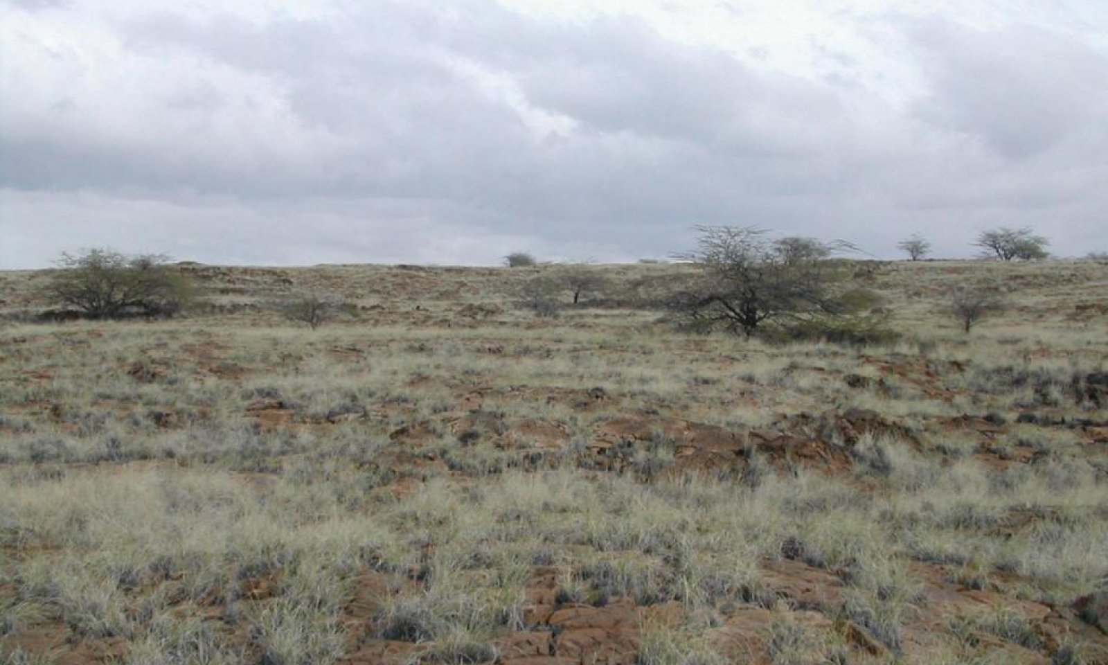
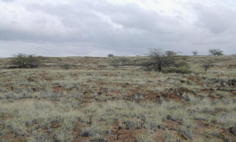
The central concept of the Isohyperthermic Desert is of well to somewhat excessively drained, shallow (over pahoehoe) to moderately deep (with high rock content) Aridisols, Entisols, and one Folist formed in volcanic ash or decomposed organic material mixed with volcanic ash. Stoniness or shallowness reduce the plant available water holding capacity of the soils. That characteristic combined with low annual rainfall (7 to 20 inches or 175 to 500 millimeters) and exceptionally warm soil temperatures (76 to 87F or 24 to 31C) result in low vegetation production. The soil temperature regime is isohyperthermic; soil moisture conditions (aridic/torric regime) are dry most of the year. Elevations range from sea level (0 to 1500 feet or 0 to 460 meters). Because very little of the original native vegetation remains, the reference state of this ecological site consists of the dominant naturalized grassland vegetation. The dominant grass species is crimson fountaingrass (Pennisetum setaceum). The dominant naturalized tree is kiawe (Prosopis pallida). The original native vegetation was dry savanna or shrubland. Some common native species, based on the current environment and remnant occurrences, are alahee (Psydrax odorata), ohe makai (Polyscias sandwicensis syn. Reynoldsia sandwicensis), wiliwili (Erythrina sandwicensis), naio (Myoporum sandwicense), aalii (Dodonaea viscosa), ilima (Sida fallax), and native grasses.
Associated sites
| VX161B01X501 |
Kona Weather Ustic Forest The Kona Weather Ustic Forest adjoins this ecological site where they meet on the west coast of Hawaii. It occurs in a cooler, moister, and cloudier climate on soils that generally have higher water-holding capacity and organic matter content than the Aridic Desert. |
|---|---|
| VX161B01X500 |
Ustic Isothermic Forest The Ustic Isothermic Forest adjoins this ecological site where they meet at the higher elevations of this ecological site. It occurs in a cooler, moister, and cloudier climate on soils that have higher water-holding capacity and organic matter content than the Aridic Desert. The Ustic Isothermic Forest supports open to closed canopy, medium stature native forest rather than native shrubland, and the main introduced forage species is kikuyugrass rather than fountaingrass or buffelgrass. |
| VX157X01X003 |
Rocky Volcanic Ash Savanna Kiawe/buffelgrass (Prosopis pallida/Pennisetum ciliare) The Rocky Volcanic Ash Savanna occurs on deeper soils with higher water holding capacity and organic matter content than this ecological site. It supports denser, taller stands of kiawe than this ecological site probably supported denser native vegetation with more trees than this ecological site. The main forage species is buffelgrass rather than fountaingrass with some buffelgrass as found in this ecological site. However, fountaingrass may invade this ecological site in time. |
Similar sites
| VX157X01X001 |
Torric Naturalized Grassland The Torric Naturalized Grassland is at South Point on the island of Hawaii. Similarly to this ecological site, it has a very warm, dry climate and soils with low water holding capacity. However, it has higher rainfall and lower soil temperatures than this ecological site. |
|---|---|
| VX158X01X002 |
Isohyperthermic Torric Naturalized Grassland Kiawe/buffelgrass (Prosopis pallida/Pennisetum ciliare) The Isohyperthermic Torric Naturalized Grassland occurs on all the major islands except Hawaii. It has a similarly very warm, dry climate to this ecological site but with higher rainfall and lower soil temperatures. It also has deeper soils with greater water holding capacity, and the soils are mostly Mollisols and Oxisols rather than the Aridisols, Entisols, and Histosols of this ecological site. Buffelgrass and, in moister areas, guineagrass are the main forage species in the Isohyperthermic Torric Naturalized Grassland, rather than crimson fountaingrass. As of now, there is little indication of fountaingrass invasion being allowed to gain a foothold on the islands on which that ecological site occurs. |
| VX158X01X004 |
Rocky Isohyperthermic Torric Naturalized Grassland Kiawe/uhaloa/buffelgrass (Prosopis pallida/Waltheria indica/Pennisetum ciliare) The Rocky Isohyperthermic Torric Naturalized Grassland occurs on all the major islands except Hawaii. It has a similarly very warm, dry climate to this ecological site with similar rainfal but lower soil temperatures. It also has soils with low water holding capacity. The soils are mostly Mollisols and Oxisols rather than the Aridisols, Entisols, and Histosols of this ecological site. Buffelgrass is the main forage species in the Rocky Isohyperthermic Torric Naturalized Grassland, rather than crimson fountaingrass. As of now, there is little indication of fountaingrass invasion being allowed to gain a foothold on the islands on which that ecological site occurs. |
Table 1. Dominant plant species
| Tree |
(1) Prosopis pallida |
|---|---|
| Shrub |
Not specified |
| Herbaceous |
(1) Pennisetum setaceum |
Legacy ID
R161AY001HI
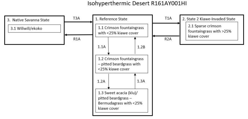
Click on box and path labels to scroll to the respective text.
| T1A | - | State 1 Reference transitions to State 2 Kiawe-Invaded with lack of brush management practices or absence of fire. |
|---|---|---|
| R2A | - | State 2 Kiawe Invaded can be restored to State 1 Reference by applying brush management. There may be insufficient fine fuels to carry fire. |
State 1 submodel, plant communities
| 1.1A | - | Crimson fountaingrass cover and vigor are reduced by continuous grazing, causing it to decrease and be partially replaced by less desirable forages. |
|---|---|---|
| 1.2B | - | Phase 1.2 can change to phase 1.1 by application of a prescribed grazing program that allows crimson fountaingrass to reassume dominance. Weed control may be necessary if taller weedy forbs and/or shrubs are abundant. |
| 1.2A | - | This community phase changes to phase 1.3 with long-term and/or heavy continuous grazing. Species composition changes to dominance by short grasses, weedy forbs, and shrubs. Bare ground increases markedly. |
| 1.3A | - | Community phase 1.3 can change to phase 1.2 by application of a prescribed grazing program that allows crimson fountaingrass to reassume dominance. Herbicidal weed control may be necessary. |