Ecological dynamics
Flooding
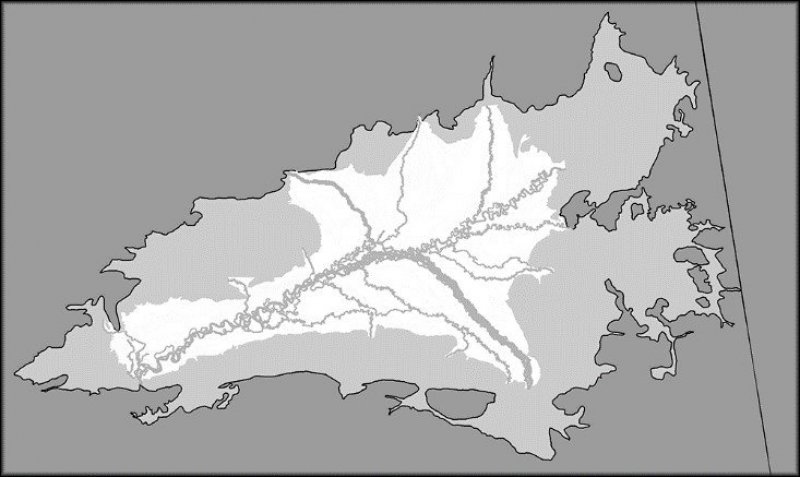
All major tributaries within the Yukon Flats Lowlands have low, middle, and/or high flood plain ecological sites. These flood plain ecological sites represent major breaks in the flood regime (i.e. flood frequency and flood duration) and dominant vegetative type on associated tributaries. The low flood plain ecological site is thought to flood frequently (>50 times in 100 years) for long durations of time (7 to 30 days) and supports a willow (Salix spp.) dominant reference plant community. Middle flood plain positions are thought to flood occasionally for long durations of time and supports a balsam poplar (Populus balsamifera) dominant reference plant community. High flood plain positions are thought to flood occasionally for brief durations of time and supports a white spruce dominant reference plant community.
The shift of vegetative type from willow to white spruce dominance represents riparian primary succession along major tributaries in the Yukon Flats Lowlands MLRA. This successional process is thought to take between 200 and 300 years in Interior Alaska (Chapin et al. 2006). The flood regime, growth traits of vegetation, biotic competition, and a slew of other factors contribute to the dynamic nature of boreal flood plain succession. For more detailed information on boreal flood plain succession and successional drivers, refer to Walker et al. (1986) and Chapin et al. (2006).
Field work indicates that certain sampled communities within the reference state flood more frequently than other communities. As flooding frequency increases, bryophyte cover decreases and balsam poplar, shrub, and woody debris cover increases. Given this observation, a more frequently flooded plant community was incorporated into the reference state (community 1.6). This community phase likely represents the transition in succession from the middle to high flood plain.
Fire
In the Yukon Flats Lowlands MLRA, fire is a common and natural event that has a significant control on the vegetation dynamics across the landscape. A typical fire event in areas associated with this ecological site will reset the plant succession and alter dynamic soil properties (e.g., presence or thickness of permafrost). For this ecological site to progress from the pioneering fire stage to the reference plant community, data suggest that 100 years or more must elapse without another fire event.
When comparing all MLRAs of Interior Alaska, land in the Yukon Flats Lowlands MLRA burns most frequently (Begét et al. 2006). Within this MLRA, fire is considered a natural and common event that typically is unmanaged. Fire suppression generally occurs adjacent to villages or on allotments with known structures, both of which have a relatively limited acre footprint. From 2000 to 2015, 132 known fire events occurred on land in the Yukon Flats Lowlands MLRA and the burn perimeter of the fires totaled about 4.1 million acres (AICC 2016). Fire-related disturbances are highly patchy and can leave undisturbed areas within the burn perimeter. Ten of the fire events were attributed to human activities (affecting a total of 2,864 acres), but the majority were caused by lightning strikes (AICC 2016).
The fire regime within Interior Alaska follows two basic scenarios—low-severity burns and high-severity burns. It should be noted, however, that the fire regime in Interior Alaska is generally thought to be much more complex (Johnstone et al. 2008). Burn severity refers to the proportion of the vegetative canopy and organic material consumed in a fire event (Chapin et al. 2006). Fires in cool and moist habitat tend to result in low-severity burns, while fires in warm and dry habitat tend to result in high-severity burns. As a result of field observations and because the associated soils are warm and well drained, the typical fire scenario for this ecological site is considered to result in a high-severity burn.
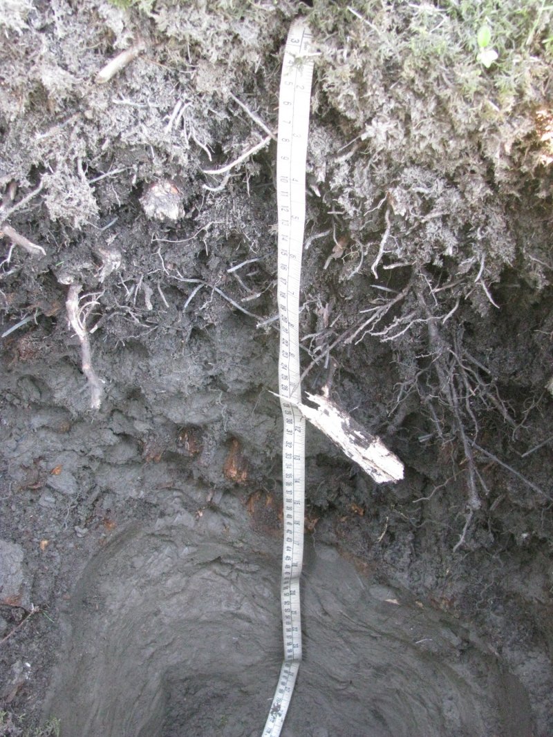
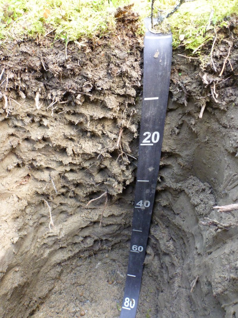
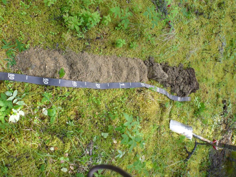
Large portions of the organic mat are consumed during a high-severity fire event, commonly exposing pockets of mineral soil. The loss of this organic mat, which insulates the mineral soil, and the decrease in site albedo tends to cause overall soil temperatures to increase (Hinzman et al. 2006). In areas that have permafrost before a fire event, the increase in soil temperatures leads to a decrease in the depth to the permafrost or loss of permafrost in the soil profile (Hinzman et al. 2006). For this ecological site, permafrost was typically not observed in the soil profiles after recent fire events and a soil component was developed for this change in dynamic soil properties (Typic Cryorthents, occasionally flooded soils). For soils that do not have a gravelly subsoil, data from fieldwork indicate that permafrost aggradation in the soil profile typically does not occur until community 1.2 and that permafrost is commonly associated with community 1.1 (Kingslough soils). Fire events also destroy a majority of the vascular and nonvascular biomass above ground.
Field data suggest that each of the forested communities will burn and that fire events will cause a transition to the pioneering stage of fire succession. This stage (community 1.5) is a mix of species that either regenerate in place (e.g., subterranean root crowns for willow and rhizomes for graminoids) and/or from wind-dispersed seed or spores that colonize exposed mineral soil (e.g., resin birch [Betula neoalaskana] and Ceratodon moss [Ceratodon purpureus]). The pioneering stage of fire succession is primarily composed of tree seedlings, forbs, grasses, and weedy bryophytes. Willow (Salix spp.) and deciduous tree seedlings continue to colonize and grow on recently burned sites until they become dominant in the overstory, which marks the transition to the early stage of fire succession (community 1.4). In the absence of fire, tree species continue to become more dominant in the stand. The later stages of succession have an overstory that is dominantly deciduous trees (community 1.3), a mix of broadleaf and needleleaf trees (community 1.2), or needleleaf trees (community 1.1).
The time elapsed since the most recent fire event plays a large role in determining the plant community observed in the field. Using data from the burn perimeter (AICC 2016) and tree age, the pioneering fire stage is thought to persist for up to 10 years post fire and the early fire community persists about 10 to 30 years postfire. After approximately 30 years, an open forest with some combination of resin birch and white spruce will persist until the next fire event. Field data suggest that broadleaf trees (primarily resin birch) are dominant in the canopy structure during the first 30 to 60 years post fire. During this timeframe, white spruce colonizes and matures in the understory. Eventually, white spruce gains dominance in the overstory and begins to replace the shade-intolerant broadleaf tree species. Late-fire community 1.2 has a mixture of immature and mature white spruce, while the reference community has a stand composed primarily of mature white spruce. The average age of white spruce in the reference plant community 1.1 is 127 years; therefore, it takes more than a century to progress from the pioneering stage to the reference community.
Other Observations
Animal use (browsing and grazing) of this ecological site primarily consists of moose browse on willow and tree regeneration, which was common in each community. Even though cover by willow and tree regeneration is highest in community 1.5 and 1.4, the severity of moose browse is considered slight for all reference state plant communities. A browse severity rating of slight on willow and tree regeneration is defined as a majority of individuals having no signs of browsing.
When flooding becomes rare, these high flood plain positions transition to terraces. Plant communities and soils sampled in these transitional areas are highly variable. For instance, some sampled flood plain soils appear to undergo paludification while others do not. Due to this variability, data gathered from transitional areas were excluded from the conceptual model for this ecological site.
No alternative states for this ecological site were documented.
State 1
Reference State
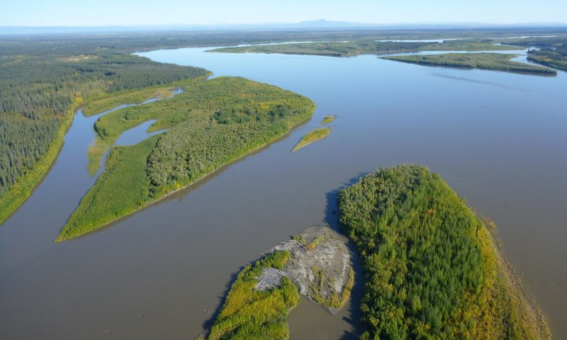
Figure 10. The Yukon River flood plain. This ecological site occurs on the flood plains of large tributaries in the Yukon Flats Lowlands MLRA.
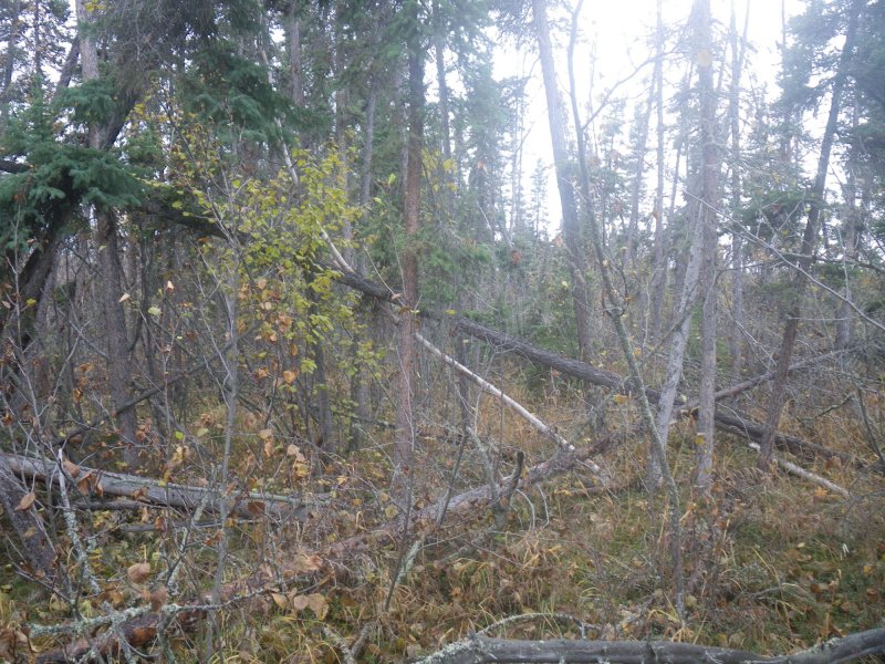
The reference state has seven associated plant communities. These communities are grouped by the structure and dominance of the vegetation (e.g., coniferous trees, deciduous trees, shrubs, and forbs) and their ecological function and stability. Plant communities in the reference state appear to be largely controlled by the influences of flooding, fire, and tree throw.
This report provides baseline vegetation inventory data for the ecological site. More data collection is needed to provide further information about existing plant communities and the disturbance regimes that would result in transitions from one community or state to another. The common and scientific plant names are from the USDA PLANTS database. All community phases in this report are characterized using the Alaska Vegetation Classification (Viereck et al. 1992).
Community 1.1
White spruce / prickly rose-squashberry / horsetail
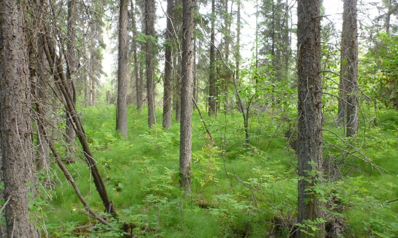
Figure 11. Typical plant community associated with community 1.1.
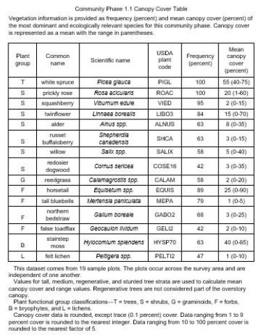
Figure 12. Canopy cover table for community 1.1.
Reference plant community 1.1 is characterized as an open needleleaf forest (25 to 60 percent cover) composed primarily of mature white spruce. The majority of the white spruce trees are similar in size and age, and the tree cover is primarily in the tall tree stratum (greater than 40 feet in height). Gaps occur in the tree canopy, but they are limited in size and extent and are likely the result of occasional windthrow. Live deciduous trees, primarily resin birch and balsam poplar (Populus balsamifera), occasionally occur in the tree canopy, but most have been replaced by white spruce. The soil surface is primarily covered with herbaceous litter, woody debris, and bryophytes.
Commonly observed understory species include prickly rose, squashberry, twinflower, a mixture of alder species (most commonly Alnus incana ssp. tenuifolia), a mixture of horsetail species (most commonly Equisetum arvense), tall bluebell, and splendid feathermoss. The understory vegetative strata that characterize this community are bryophytes, medium forbs (4 to 24 inches in height), dwarf shrubs (less than 8 inches), and medium shrubs (between 3 and 10 feet).
White spruce trees were sampled for diameter at breast height (dbh), height, and age at dbh (80 trees). The basal area of the stand and the site index were determined for each sample plot. The mean dbh is 11.0 inches (ranging from 7.5 to 25.0), the mean height is 71 feet (ranging from 45 to 98 feet), and the mean age is 127 years (ranging from 65 to 215 years). The mean basal area of the stands is 151 (ranging from 100 to 220), and mean site index is 66 (ranging from 49 to 84) (Farr 1967).
Forest overstory. Stand basal area: low 100, mean 151, high 220.
Dominant plant species
-
white spruce (Picea glauca), tree
-
prickly rose (Rosa acicularis), shrub
-
squashberry (Viburnum edule), shrub
-
twinflower (Linnaea borealis), shrub
-
thinleaf alder (Alnus incana ssp. tenuifolia), shrub
-
russet buffaloberry (Shepherdia canadensis), shrub
-
willow (Salix), shrub
-
redosier dogwood (Cornus sericea), shrub
-
reedgrass (Calamagrostis), grass
-
field horsetail (Equisetum arvense), other herbaceous
-
marsh horsetail (Equisetum palustre), other herbaceous
-
splendid feather moss (Hylocomium splendens), other herbaceous
-
tall bluebells (Mertensia paniculata), other herbaceous
-
northern bedstraw (Galium boreale), other herbaceous
-
false toadflax (Geocaulon lividum), other herbaceous
-
felt lichen (Peltigera), other herbaceous
Community 1.2
White spruce-resin birch / prickly rose / horsetail
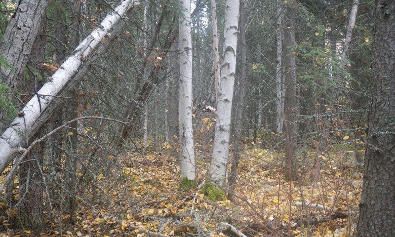
Figure 13. Typical plant community associated with community 1.2.
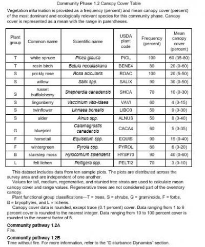
Figure 14. Canopy cover table for community 1.2.
Plant community 1.2 is in the late stage of fire-induced secondary succession for this ecological site. It is characterized as an open mixed forest (25 to 60 percent cover) (fig.4). Deciduous trees, primarily mature resin birch, are starting to be replaced by white spruce in the tree canopy. White spruce cover is generally split between immature medium-sized trees (15 to 40 feet in height) and mature tall trees (greater than 40 feet in height). The soil surface is primarily covered with herbaceous litter, woody debris, and bryophytes.
Commonly observed understory species include prickly rose, a mixture of willow (most commonly Salix bebbiana and Salix arbusculoides), russet buffaloberry, a mixture of horsetail (most commonly E. arvense and E. pratense), russet buffaloberry (Shepherdia canadensis), stairstep moss, and felt lichen (Peltigera spp.). The understory vegetative strata that characterize this community are bryophytes, medium forbs (4 to 24 inches in height), low shrubs (between 8 and 36 inches), and tall shrubs (greater than 10 feet).
White spruce trees were sampled for diameter at breast height (dbh), height, and age at dbh (32 trees). The basal area of the stand was determined for each sample plot. The mean dbh is 7.9 (ranging from 2.1 to 14.0), the mean height is 50 feet (ranging from 14 to 82 feet), and the mean age is 70 years (ranging from 30 to 175 years). The mean basal area is 97 (ranging from 52 to 200).
Dominant plant species
-
white spruce (Picea glauca), tree
-
resin birch (Betula neoalaskana), tree
-
prickly rose (Rosa acicularis), shrub
-
willow (Salix), shrub
-
russet buffaloberry (Shepherdia canadensis), shrub
-
lingonberry (Vaccinium vitis-idaea), shrub
-
twinflower (Linnaea borealis), shrub
-
alder (Alnus), shrub
-
bluejoint (Calamagrostis canadensis), grass
-
field horsetail (Equisetum arvense), other herbaceous
-
meadow horsetail (Equisetum pratense), other herbaceous
-
wintergreen (Pyrola), other herbaceous
-
splendid feather moss (Hylocomium splendens), other herbaceous
-
felt lichen (Peltigera), other herbaceous
Community 1.3
Resin birch / willow-prickly rose / horsetail
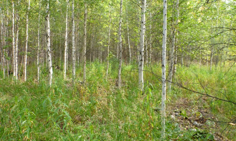
Figure 15. Typical plant community associated with community 1.3.
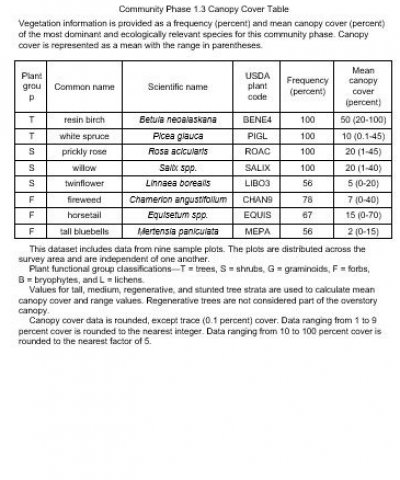
Figure 16. Canopy cover table for community 1.3.
Plant community 1.3 is in the middle stage of fire-induced secondary succession for this ecological site. It is characterized as an open broadleaf forest (25 to 60 percent cover) (fig. 5). Deciduous trees, primarily resin birch, are dominant in the tree canopy, and the majority of the tree cover is split between the medium tree (15 to 40 feet in height) and tall tree stratums (greater than 40 feet). Seedlings of white spruce are common throughout the understory. The forest floor is primarily covered with herbaceous litter and woody debris.
Commonly observed understory species include prickly rose, a mixture of willow (most commonly S. bebbiana and S. arbusculoides), fireweed (Chamerion angustifolium), and a mixture of horsetail (most commonly E. arvense and E. pratense). The understory vegetative strata that characterize this community are medium forbs (4 to 24 inches in height), low shrubs (between 8 and 36 inches), and tall shrubs (greater than 10 feet).
White spruce trees were sampled for diameter at breast height (dbh), height, and age at dbh (10 trees). The basal area of the stand was determined for each sample plot. The mean dbh is 5.1 (ranging from 1.8 to 9.8), the mean height is 34 feet (ranging from 11 to 62 feet), and the mean age is 39 years (ranging from 10 to 68 years). The mean basal area is 91 (ranging between 52 and 276).
Community 1.4
Willow-prickly rose / bluejoint / fireweed
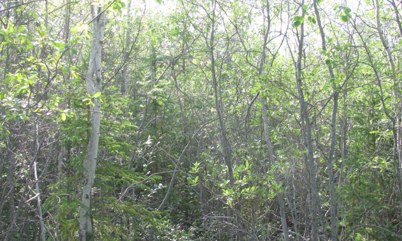
Figure 17. Typical plant community associated with community 1.4.
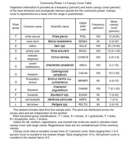
Figure 18. Canopy cover table for community 1.4.
Plant community 1.4 is in the early stage of fire-induced secondary succession for this ecological site. It is characterized as open tall scrubland and is primarily composed of a mixture of willow. White spruce and resin birch are common and cover primarily occurs in the regenerative tree stratum (less than 15 feet in height). The soil surface is primarily covered with herbaceous litter and woody debris.
Commonly observed species include an assortment of willow (most commonly S. bebbiana and S. arbusculoides), prickly rose, redosier dogwood (Cornus sericea), russet buffaloberry, bluejoint (Calamagrostis canadensis), fireweed, and a mixture of horsetail (most commonly E. arvense and E. pratense). The understory vegetative strata that characterize this community are medium forbs (4 to 24 inches in height), low shrubs (between 8 and 36 inches), medium shrubs (between 3 and 10 feet), and tall shrubs (greater than 10 feet).
Dominant plant species
-
white spruce (Picea glauca), tree
-
resin birch (Betula neoalaskana), tree
-
Bebb willow (Salix bebbiana), shrub
-
littletree willow (Salix arbusculoides), shrub
-
willow (Salix), shrub
-
redosier dogwood (Cornus sericea), shrub
-
prickly rose (Rosa acicularis), shrub
-
Pumpelly's brome (Bromus inermis ssp. pumpellianus var. pumpellianus), grass
-
fireweed (Chamerion angustifolium), other herbaceous
-
field horsetail (Equisetum arvense), other herbaceous
-
meadow horsetail (Equisetum pratense), other herbaceous
-
tall bluebells (Mertensia paniculata), other herbaceous
-
felt lichen (Peltigera), other herbaceous
Community 1.5
Fireweed / Pohlia moss-Ceratodon moss
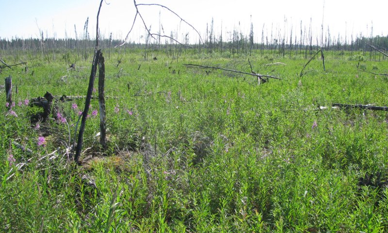
Figure 19. Typical plant community associated with community 1.5.
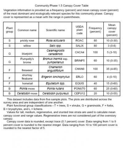
Figure 20. Canopy cover table for community 1.5.
Plant community 1.5 is in the pioneering stage of fire-induced secondary succession for this ecological site. It is characterized as mesic forb herbaceous. Tree cover is sparse and primarily occurs in the regenerative tree stratum (less than 15 feet in height). Although small areas of exposed bare soil occur, the soil surface is primarily covered with a mixture of weedy bryophyte species, woody debris, and herbaceous litter.
Commonly observed species include prickly rose, and assortment of willow (most commonly S. bebbiana), bluejoint, fireweed, Pohlia moss (Pohlia nutans), and Ceratodon moss (Ceratodon purpureus). The vegetative strata that characterize this community are bryophytes and medium forbs (4 to 24 inches in height).
Dominant plant species
-
prickly rose (Rosa acicularis), shrub
-
Bebb willow (Salix bebbiana), shrub
-
willow (Salix), shrub
-
bluejoint (Calamagrostis canadensis), grass
-
Pumpelly's brome (Bromus inermis ssp. pumpellianus var. pumpellianus), grass
-
fireweed (Chamerion angustifolium), other herbaceous
-
shortray fleabane (Erigeron lonchophyllus), other herbaceous
-
field horsetail (Equisetum arvense), other herbaceous
-
meadow horsetail (Equisetum pratense), other herbaceous
-
pohlia moss (Pohlia nutans), other herbaceous
-
ceratodon moss (Ceratodon purpureus), other herbaceous
Community 1.6
White spruce-balsam poplar / alder-prickly rose / horsetail
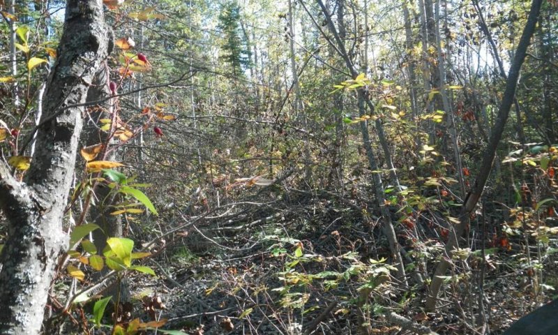
Figure 21. Typical plant community associated with community 1.6.
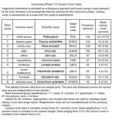
Figure 22. Canopy cover table for community 1.6.
Plant community 1.6 is more frequently flooded then the reference community 1.1. It is characterized as an open mixed forest (25 to 60 percent cover). Deciduous trees, primarily mature balsam poplar, are starting to be replaced by white spruce in the tree canopy. White spruce cover is generally split between immature medium-sized trees (15 to 40 feet in height) and mature tall trees (greater than 40 feet in height). Although small areas with feathermoss occur, the soil surface is primarily covered with a mixture of woody debris and herbaceous litter.
Commonly observed understory species include prickly rose, a mixture of alder (most commonly Alnus incana ssp. tenuifolia), a mixture of willow (most commonly S. alaxensis and S. arbusculoides), squashberry, and a mixture of horsetail (most commonly E. arvense and E. pratense). The understory vegetative strata that characterize this community are medium shrubs (3 to 10 feet in height), medium forbs (4 to 24 inches in height), and tall shrubs (greater than 10 feet).
White spruce trees were sampled for diameter at breast height (dbh), height, and age at dbh (14 trees). The basal area of the stand was determined for each sample plot. The mean dbh is 10.9 (ranging from 6.7 to 21.1), the mean height is 58 feet (ranging from 32 to 86 feet), and the mean age is 73 years (ranging from 37 to 155 years). The mean basal is 93 (ranging from 62 to 112).
Dominant plant species
-
white spruce (Picea glauca), tree
-
balsam poplar (Populus balsamifera), tree
-
prickly rose (Rosa acicularis), shrub
-
thinleaf alder (Alnus incana ssp. tenuifolia), shrub
-
Bebb willow (Salix bebbiana), shrub
-
feltleaf willow (Salix alaxensis), shrub
-
willow (Salix), shrub
-
squashberry (Viburnum edule), shrub
-
twinflower (Linnaea borealis), shrub
-
russet buffaloberry (Shepherdia canadensis), shrub
-
field horsetail (Equisetum arvense), other herbaceous
-
splendid feather moss (Hylocomium splendens), other herbaceous
Community 1.7
Alder-prickly rose / horsetail
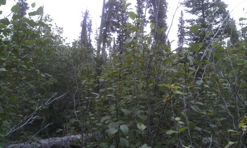
Figure 23. Typical plant community associated with community 1.7.
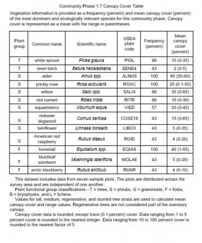
Figure 24. Canopy cover table for community 1.7.
Plant community 1.7 is in the early stage of tree throw-induced secondary succession for this ecological site. Mature white spruce are common but no longer abundant (generally less than 10% cover) and this phase is characterized as closed tall scrubland. Tree cover is split between the tall tree (greater than 40 feet) and the regenerative tree stratum (less than 15 feet in height). Although small areas with feathermoss occur, the soil surface is primarily covered with a mixture of woody debris and herbaceous litter.
Commonly observed species include a mixture of alder (most commonly A. viridis spp. fruticosa), prickly rose, an assortment of willow (most commonly S. bebbiana and S. arbusculoides), red currant (Ribes triste), and a mixture of horsetail (most commonly E. arvense and E. pratense). The understory vegetative strata that characterize this community are tall shrubs (greater than 10 feet in height), medium shrubs (between 3 and 10 feet), and medium forbs (4 to 24 inches in height).
Dominant plant species
-
white spruce (Picea glauca), tree
-
resin birch (Betula neoalaskana), tree
-
thinleaf alder (Alnus incana ssp. tenuifolia), shrub
-
Siberian alder (Alnus viridis ssp. fruticosa), shrub
-
prickly rose (Rosa acicularis), shrub
-
Bebb willow (Salix bebbiana), shrub
-
littletree willow (Salix arbusculoides), shrub
-
willow (Salix), shrub
-
red currant (Ribes triste), shrub
-
squashberry (Viburnum edule), shrub
-
redosier dogwood (Cornus sericea), shrub
-
American red raspberry (Rubus idaeus), shrub
-
field horsetail (Equisetum arvense), other herbaceous
-
bluntleaf sandwort (Moehringia lateriflora), other herbaceous
-
arctic raspberry (Rubus arcticus), other herbaceous
Pathway 1.1a
Community 1.1 to 1.5
White spruce / prickly rose-squashberry / horsetail
Fireweed / Pohlia moss-Ceratodon moss
Fire.
Pathway 1.1b
Community 1.1 to 1.6
White spruce / prickly rose-squashberry / horsetail
White spruce-balsam poplar / alder-prickly rose / horsetail
More frequent and longer duration flood events.
The reference state for this ecological site floods occasionally for brief periods of time. Areas that are thought to flood less frequently are represented by community 1.1 and areas that are thought to flood more frequently are represented by community 1.6. When compared to community 1.1, the more frequently flooded plant community (community 1.6) has less feathermoss cover and greater balsam poplar and shrub cover.
Pathway 1.1c
Community 1.1 to 1.7
White spruce / prickly rose-squashberry / horsetail
Alder-prickly rose / horsetail
In certain locations, extensive stand death of white spruce was observed. The reason for stand death remains unknown. Standing dead trees are eventually windthrown, which makes greater amounts of light available to understory vegetation. Under these circumstances, alder cover increases significantly.
Pathway 1.2b
Community 1.2 to 1.1
White spruce-resin birch / prickly rose / horsetail
White spruce / prickly rose-squashberry / horsetail
Time without fire. For more information, refer to the "ecological dynamics of the site" section.
Pathway 1.2a
Community 1.2 to 1.5
White spruce-resin birch / prickly rose / horsetail
Fireweed / Pohlia moss-Ceratodon moss
Fire.
Pathway 1.3b
Community 1.3 to 1.2
Resin birch / willow-prickly rose / horsetail
White spruce-resin birch / prickly rose / horsetail
Time without fire. For more information, refer to the "Ecological Dynamics of the Site" section.
Pathway 1.3a
Community 1.3 to 1.5
Resin birch / willow-prickly rose / horsetail
Fireweed / Pohlia moss-Ceratodon moss
Fire.
Pathway 1.4b
Community 1.4 to 1.3
Willow-prickly rose / bluejoint / fireweed
Resin birch / willow-prickly rose / horsetail
Time without fire. For more information, refer to the "Ecological Dynamics of the Site" section.
Pathway 1.4a
Community 1.4 to 1.5
Willow-prickly rose / bluejoint / fireweed
Fireweed / Pohlia moss-Ceratodon moss
Fire.
Pathway 1.5a
Community 1.5 to 1.4
Fireweed / Pohlia moss-Ceratodon moss
Willow-prickly rose / bluejoint / fireweed
Time without fire. For more information, refer to the "Ecological Dynamics of the Site" section.
Pathway 1.6b
Community 1.6 to 1.1
White spruce-balsam poplar / alder-prickly rose / horsetail
White spruce / prickly rose-squashberry / horsetail
Less frequent flooding.
The reference state for this ecological site floods occasionally for brief periods of time. Areas that are thought to flood less frequently are represented by community 1.1 and areas that are thought to flood more frequently are represented by community 1.6. When compared to community 1.1, the more frequently flooded plant community (community 1.6) has less feathermoss cover and greater balsam poplar and shrub cover.
Pathway 1.6a
Community 1.6 to 1.5
White spruce-balsam poplar / alder-prickly rose / horsetail
Fireweed / Pohlia moss-Ceratodon moss
Fire.
Pathway 1.7b
Community 1.7 to 1.1
Alder-prickly rose / horsetail
White spruce / prickly rose-squashberry / horsetail
Tree throw recovery.
Seedlings of white spruce will continue to colonize and mature. The stand is thought to eventually revert back to conditions represented by reference plant community 1.1.
Pathway 1.7a
Community 1.7 to 1.5
Alder-prickly rose / horsetail
Fireweed / Pohlia moss-Ceratodon moss
Fire.


