Ecological dynamics
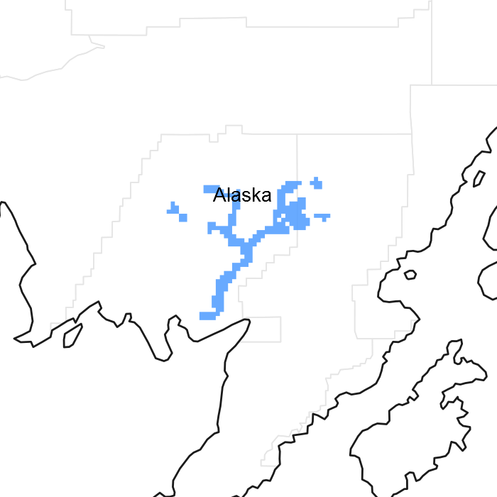
This site is on high flood plains. Local site factors, including microtopographic elevation, soil characteristics, and flood energy create four co-occurring vegetative communities. The reference plant community is a mixed birch and white spruce forest. Gravelly soils are more likely to support more trees than shrubs, while the opposite is true for loamy soil. Areas that experience high energy flood events are most likely to support scrublands and meadows of resilient shrubs and fast growing herbaceous species
Spatial and temporal patterns in soil and site hydrology create four flood plain communities. Flood events do not prevent tree growth on areas distal from the river channel. Vegetation on low areas along main river channels is influenced by scouring from relatively high energy flooding and ice bulldozing. Plants are primarily resilient shrubs and fast growing herbaceous species. Loamy soils are poorly drained and are typically not scoured. These localized areas support hydrophytic vegetation along with sporadic trees.
Changes in hydrology due to the movement of river channels can shift one community to the other. Scouring of loamy soil may expose existing gravels and deposit new gravels, creating better drained soil. Channel movement also creates areas of low flood energy, allowing fine material deposits to accumulate and changing soil hydrology. These changes are slow and dictated by movement of a river across a floodplain.
Windthrow has been observed in the reference plant community. It may contribute to keeping the forest canopy open and promoting plant diversity in the understory. Willows are browsed by moose. This does not appear to affect the ecological processes of the site.
Beaver-affected areas are described by an alternate state. In these areas, Alaska paper birch (Betula neoalaskana), bluejoint (Calamagrostis canadensis), and hydrophilic forbs typically surround the ponds upstream of the beaver dam. It is unknown if the pond will naturally return to the reference state after dam removal.
The information in this Ecological Dynamics section, including the state-and-transition model (STM), was developed based on current field data, professional experience, and a review of the scientific literature. As a result, all possible scenarios or plant species may not be included. Key indicator plant species, disturbances, and ecological processes are described to inform land management decisions.
State 1
Reference State
The reference state supports four community phases, which are grouped by the structure and dominance of the vegetation (e.g., coniferous trees, deciduous trees, shrubs, and forbs) and by their ecological function and stability. The presence of these communities is temporally dictated by rare periods of flooding. The reference community phase is a mixed forest and an open understory of bluejoint grass (Calamagrostis canadensis) and diverse forbs and shrubs. An alternative state is caused by the damming of nearby drainageways or streams by beavers (Castor canadensis).
Community 1.1
Mixed birch-white spruce/bluejoint grass/horsetails-woodfern/alder-spirea forest
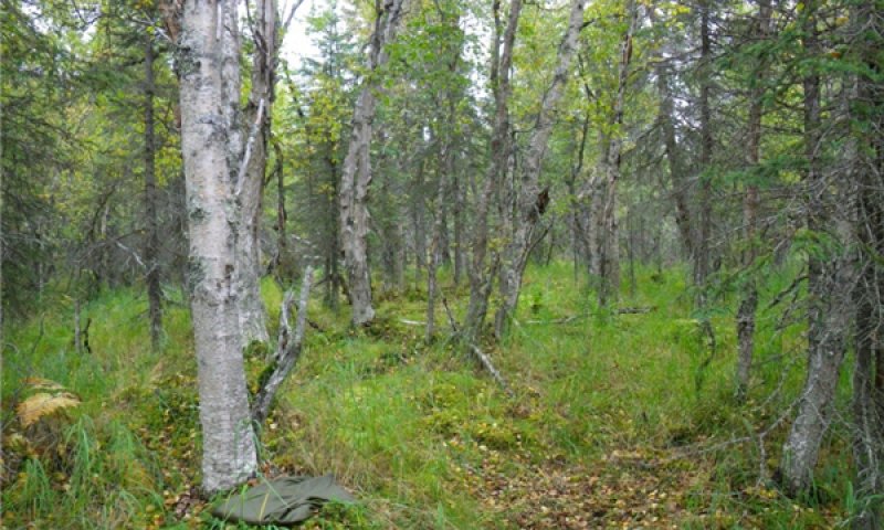
Figure 8. Typical area of community 1.1.
The reference community phase for this ecological site is characterized by a mixed coniferous and deciduous forest and an open understory of bluejoint grass (Calamagrostis canadensis) and diverse forbs and shrubs. The majority of the tree cover is in the tall and medium strata. Typically, the dominant species are white spruce (Picea glauca) and paper birch (Betula papyrifera), but other trees such as Alaska paper birch (Betula neoalaskana), Kenai birch (Betula papyrifera var. kenaica), and balsam poplar (Populus balsamifera) may be present. The dominant understory species include bluejoint grass (Calamagrostis canadensis), arctic raspberry (Rubus arcticus), spreading woodfern (Dryopteris expansa), and horsetails (Equisetum spp.). Other less abundant species may include highbush cranberry (Viburnum edule), alder (Alnus spp.), and spirea (Spiraea stevenii). Feathermosses, such as splendid feathermoss (Hylocomium splendens) and knights plume moss (Ptilium crista-castrensis), commonly are on the surface along with a minor amount of lichens. Other ground cover commonly includes herbaceous litter (about 65 percent average cover) and woody litter (about 9 percent average cover). About 1 percent is bare soil.
Community 1.2
Paper birch-Kenai birch-balsam poplar/alder-willow/bluejoint grass/horsetail forest
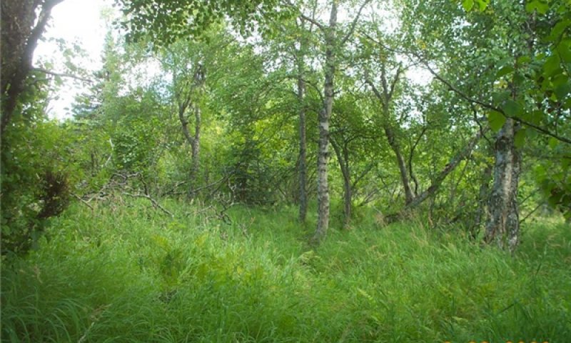
Figure 9. Typical area of community 1.2.
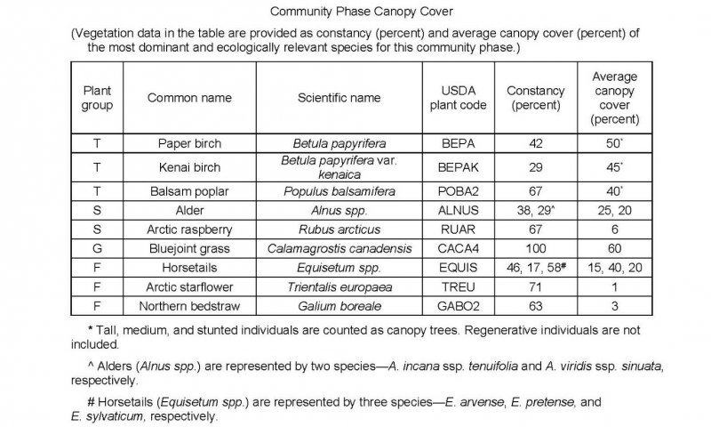
Figure 10. Constancy and canopy cover of plant species in community 1.2.
This late flooding community phase is characterized by a deciduous forest and an understory of dominantly bluejoint grass (Calamagrostis canadensis) and various shrubs and forbs. Commonly, two or more deciduous species are present, including balsam poplar (Populus balsamifera), paper birch (Betula papyrifera), Kenai birch (Betula papyrifera var. kenaica), and Alaska paper birch (Betula neoalaskana). The understory commonly includes bluejoint grass (Calamagrostis canadensis), arctic raspberry (Rubus arcticus), alder (Alnus spp.), and horsetails (Equisetum spp.). Other less common understory species include various shade-tolerant, competitive forbs such are arctic starflower (Trientalis europaea), spreading woodfern (Dryopteris expansa), fireweed (Chamerion angustifolium), and western touch-me-not (Impatiens noli-tangere) and colonizing highbush cranberry (Viburnum edule). The ground cover commonly consists of patchy mosses (about 20 percent average cover) and a minor component of lichens (about 1 percent). Other ground cover commonly includes herbaceous litter (about 80 percent average cover) and woody litter (about 8 percent). About 1 percent is bare soil.
Community 1.3
Arctic raspberry-Sitka alder-willow/bluejoint grass/horsetail-fireweed open scrubland
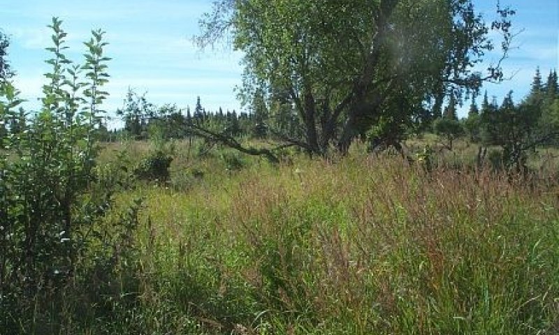
Figure 11. Typical area of community 1.3.
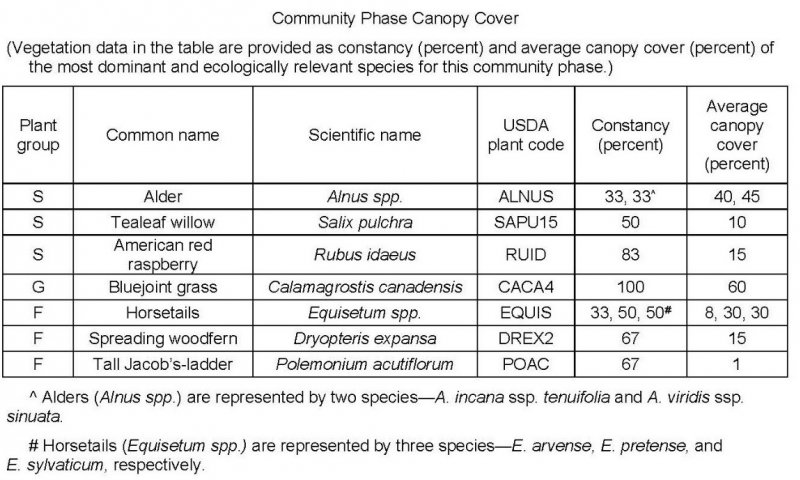
Figure 12. Constancy and canopy cover of plant species in community 1.3.
This mid flooding community phase is typified by open scrubland that consists of a mix of shrubs and large open areas of bluejoint grass (Calamagrostis canadensis) and pioneer, disturbance-loving forbs. Common medium and tall shrubs include alders (Alnus spp.) and tealeaf willow (Salix pulchra). Regenerating and hardy trees that survived previous periods of flooding may be present and can include any or all of the species in the reference community phase. Open areas consist dominantly of bluejoint grass, but commonly include American red raspberry (Rubus idaeus), fireweed (Chamerion angustifolium), kneeling angelica (Angelica genuflexa), and horsetails (Equisetum spp.). The ground cover may include myriad mosses (about 50 percent average cover), herbaceous litter (about 65 percent), and woody litter (about 4 percent). As much as 1 percent is bare soil.
Community 1.4
Forb/graminoid meadow
This early flooding community phase typically is characterized by pioneer, disturbance-loving forbs and graminoids. These fast-growing plants typically spread by water- or wind-borne seeds, which allows for rapid colonization after a disturbance. Graminoids may include bluejoint grass (Calamagrostis canadensis) and various sedges (Carex spp.). Many species of forbs may be present, including fireweed (Chamerion angustifolium), horsetails (Equisetum spp.), and goldenrods (Solidago spp.). Hardy individual shrubs and trees that survived periods of flooding may be present.
Note: This early flooding community phase was not observed in the field. This description is based on published literature and similar early post-flooding community phases on flood plains in southwestern Alaska.
Pathway 1.1a
Community 1.1 to 1.4
Major flooding can inundate the flood plains and cause erosion, deposition of sediment, and scouring of vegetation. Rare post-flood periods of ponding may also affect the composition of the plant community and result in transitions. Forbs and graminoids may colonize, and some water-tolerant trees and shrubs may survive. The frequency of flooding is rare or occasional. The white spruce (Picea glauca) trees are 55 to 200 years old or more (mean age of 105 years), which suggests that the typical major flood regime is once per century (100 years).
Pathway 1.2a
Community 1.2 to 1.1
Paper birch-Kenai birch-balsam poplar/alder-willow/bluejoint grass/horsetail forest
Mixed birch-white spruce/bluejoint grass/horsetails-woodfern/alder-spirea forest
Natural succession: Normal time and growth without disruptive flooding.
Over time white spruce trees will increase in size and abundance and outcompete willow and alder for light and space; thus, the population of these species will decline. The period needed for this transition currently is unknown, but it likely is determined partially by the spread and growth rate of white spruce.
Pathway 1.2b
Community 1.2 to 1.4
Flooding.
Although the flooding regime of this ecological site is very rare to occasional, a flood occurring within about 45 to 75 years of the last major flood likely will have effects similar to those described for transition pathway 1.1a.
Pathway 1.3a
Community 1.3 to 1.2
Arctic raspberry-Sitka alder-willow/bluejoint grass/horsetail-fireweed open scrubland
Paper birch-Kenai birch-balsam poplar/alder-willow/bluejoint grass/horsetail forest
Natural succession: Normal time and growth without disruptive flooding.
Over time without further flooding, the abundance and diversity of existing, colonizing shrubs and trees that are competitive will increase. The diversity of graminoids and forbs may increase also as new ecological niches expand. The period needed for this transition is unknown, but it likely depends at least partially on the colonization and growth rate of shrubs and trees.
Pathway 1.3b
Community 1.3 to 1.4
Flooding.
Although the frequency of flooding is very rare to occasional, flooding of plant community 1.3 likely will have effects similar to those described for pathway 1.2a. The probability of more than one flood occurring in a short period is relatively low.
Pathway 1.4a
Community 1.4 to 1.3
Natural succession: Normal time and growth without disruptive flooding.
Over time shrubs likely will colonize and spread. The populations of existing forbs competing for space and sunlight may decrease, but the overall richness of the forbs is expected to increase as niches increase. Graminoids, particularly bluejoint grass, will continue to thrive.
State 2
Beaver-affected Areas
This alternate state is a result of ponding from beaver activity. Beavers (Castor canadensis) directly kill trees and large shrubs to use for food and dam construction and indirectly kill these species and others by raising the water table (USDA–FS, 2013). Ponding generally creates a vegetative community that is different from those normally on these flood plains. This plant community commonly includes resilient individual extant species present in the reference community phase and pioneer hydrophilic species. Permanent ponding associated with areas upstream from beaver dams can negate the influence of flooding on the soils and vegetation. The vegetative community is likely to remain relatively stable until the dam is removed. When the dam is removed by natural events, beaver abandonment, or human intervention, it is thought that the plant community will revert to the reference state. Further research is needed to quantify the outcome of dam removal in situ .
Moderate or severe browsing of willow by moose has been observed on this alternate state community. The browsing may prevent willows from becoming dominant and maintain the community as open woodland rather than transitioning to closed scrubland.
Community 2.1
Paper birch/bluejoint grass/tealeaf willow/horsetails-purple marshlocks woodland
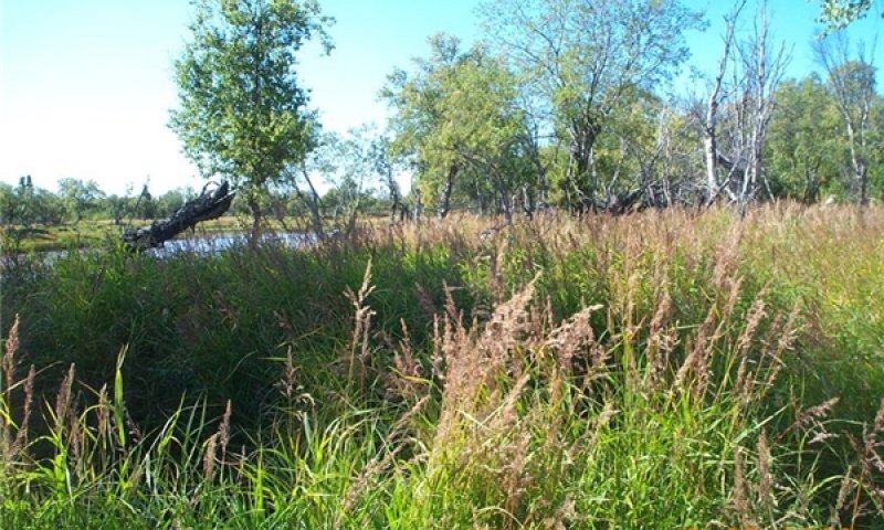
Figure 13. Typical area of community 2.1.
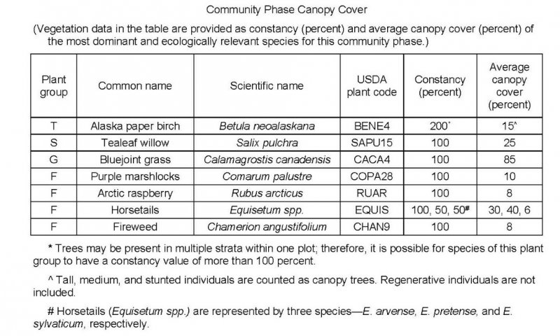
Figure 14. Constancy and canopy cover of plant species in community 2.1.
This community phase is associated with areas surrounding beaver ponds. It is characterized by open woodland that has disturbance-loving, hydrophilic species in the understory and in non-treed areas. The woodland generally consists dominantly of Alaska paper birch (Betula neoalaskana) in the medium and regenerative strata. The understory and open areas commonly support species such as bluejoint grass (Calamagrostis canadensis), purple marshlocks (Comarum palustre), tealeaf willow (Salix pulchra), and arctic raspberry (Rubus arcticus). Less dominant understory species include various willows (Salix spp.), horsetails (Equisetum spp.), spreading woodfern (Dryopteris expansa), and fireweed (Chamerion angustifolium). The ground cover typically consists of clusters of moss (about 25 percent average cover), herbaceous litter (about 95 percent), woody litter (about 2 percent), and rock fragments (about 1 percent). About 5 percent is bare soil.
Note: The vegetation and soils in two areas of this plant community phase were sampled. Due to the limited data available, personal field observations were used to aid in describing the community.
Transition T1A
State 1 to 2
This transition is caused by the damming of a water source by beavers. Areas surrounding beaver ponds may support plant assemblages distinct from those typically on these high flood plains. The vegetative community generally is comprised of species that are water tolerant and can reproduce in wet soils. Areas surrounding beaver ponds may be susceptible to flooding or ponding after rainfall and snowmelt. This prevents the vegetative community from supporting non-hydrophilic species, which may keep the composition of the plant community relatively stable. The time required for this transition depends on the presence and activity of beavers.
Restoration pathway R2A
State 2 to 1
This restorative pathway to the reference state occurs in areas where a beaver dam is removed. This can be a result of flooding, inactivity by beavers, or anthropogenic activity. Once a dam is removed, the plant community is expected to transition back to the reference state. This depends on factors such as the existing seed bank, propagule recruitment, and return of the natural flooding regime. Further research and in situ documentation is needed to fully describe this pathway.


