Ecological dynamics
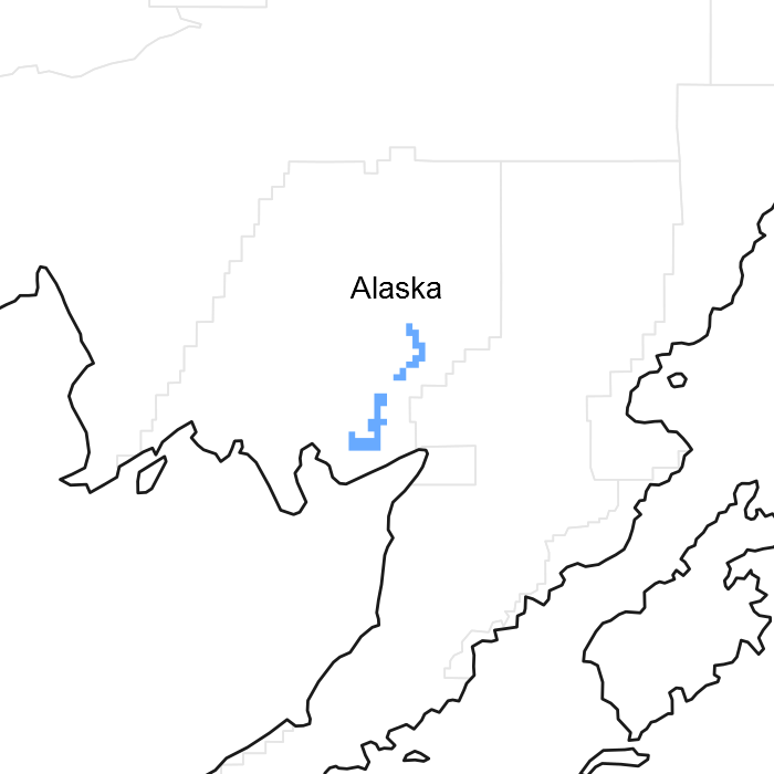
This boreal ecological site is on linear to concave areas of upland escarpments. It typically is at sea level to an elevation of 410 feet, and it has slopes of 15 to 60 percent. The site generally is on northeast- to southwest-facing slopes of the bluff along the Nushagak River (about 40 to 220 degrees).
This ecological site is correlated to D36-Boreal forest sandy colluvial slopes, wet. This soil has a cryic temperature regime and a udic moisture regime. The saturated hydraulic conductivity is moderately low to a depth of 40 inches. The upper mineral horizon is very strongly acid to slightly acid (pH 4.7 to 6.2), and it has an organic matter content of 7 to 9 percent. The soil is somewhat poorly drained. The runoff potential is medium. The annual precipitation is 24 to 35 inches, and the annual frost-free period is 85 to 140 days. The soil formed in sandy colluvium over gravelly slide deposits.
The reference community phase is characterized by a birch forest and an understory of various shrubs, forbs, and bluejoint grass (Calamagrostis canadensis). Ecological site F236XY113AK (Boreal Forest Loamy Slopes, Steep) is also on boreal upland escarpments, but it is in linear to convex areas. Differences in the natural drainage class, runoff potential, and depth to the water table in the soil leads to dissimilarities in the reference states and community phases, which makes use of separate ecological sites necessary.
Erosion caused by windthrow and landslides is the major documented disturbance regime; it is considered natural and typically is unmanaged. The steep escarpments are susceptible to landslides, and the trees may be susceptible to windthrow. The available background information shows that small-scale windthrow results in the snapping of boles and uprooting of trees. Susceptibility commonly is related to the age and height of the trees, rooting depth, and saturation of the soils (USDA-FS, 2013). Most or all of the extant vegetation may be removed. Because this site is in concave areas, surface runoff accumulates and seepage occurs. The site is inherently wet (mainly during snowmelt), particularly as compared to site F236XY113AK. This affects the composition of the plant communities.
Slight or moderate browsing by moose on various plants may occur in this site, but it does not appear to affect the ecological processes significantly enough to alter the communities.
State 1
Reference State
The reference state supports three community phases, which are grouped by the structure and dominance of the vegetation (trees, shrubs, graminoids, and forbs) and by their ecological function and stability. The reference community phase is characterized by a birch forest and diverse understory that commonly consists of water-tolerant shrubs, graminoids, and forbs. The presence of the community phases is dictated temporally by erosion and the movement of surface or subsurface water. No alternate states have been observed.
Community 1.1
Kenai birch-paper birch/Sitka alder-cloudberry/bluejoint grass/horsetails/moss forest
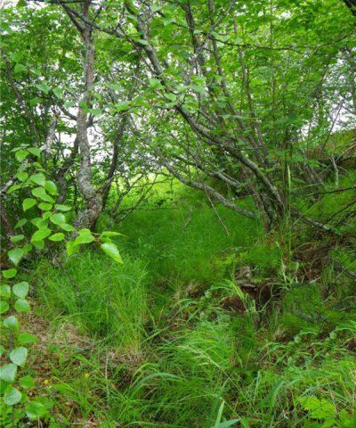
Figure 2. Typical area of community 1.1.
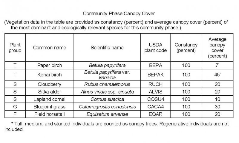
Figure 3. Constancy and canopy cover of plant species in community 1.1.
The reference community phase is characterized by a birch forest and diverse understory that commonly consists of water-tolerant shrubs, graminoids, and forbs. Trees commonly are in the medium or regenerative stratum. Typically, the community consists of paper birch (Betula papyrifera) or Kenai birch (Betula papyrifera var. kenaica) and an understory of Sitka alder (Alnus viridis ssp. sinuata), cloudberry (Rubus chamaemorus), bluejoint grass (Calamagrostis canadensis), and horsetails (Equisetum arvense, E. sylvaticum). Other extant species may include fireweed (Chamerion angustifolium), sweetgale (Myrica gale), tufted hairgrass (Deschampsia cespitosa), and Lapland cornel (Cornus suecica). Many of the plants are facultative or obligate wetland species, which is indicative of the wetness of the concave areas. A high density of mosses, particularly hydrophilic sphagnum mosses (Sphagnum spp.), is present (about 60 percent cover). Other ground cover includes herbaceous litter (about 45 percent cover ) and woody litter (about 3 percent).
Note: The vegetation and soils of this community were sampled at two locations. Due to the limited data available, personal field observations were used to aid in describing the plant community.
Community 1.2
Sitka alder/bluejoint grass/field horsetail scrubland
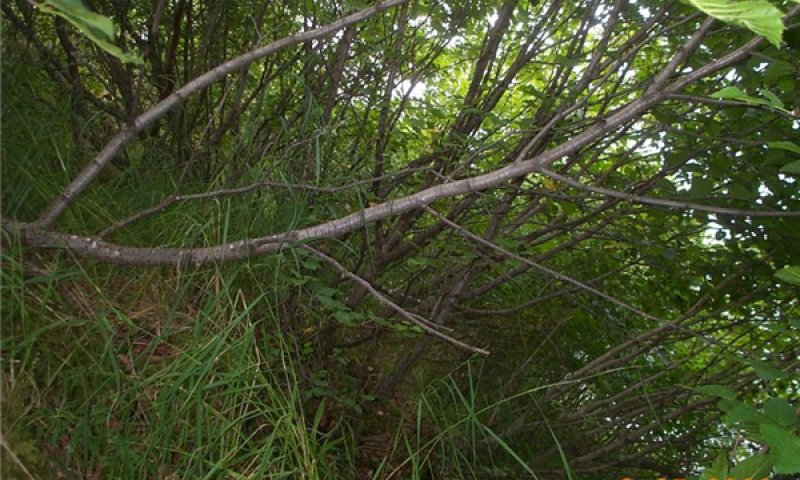
Figure 4. Typical area of community 1.2.
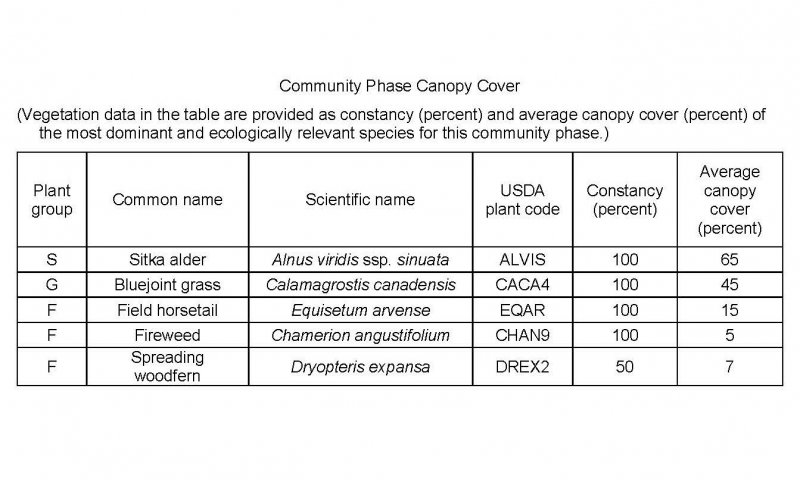
Figure 5. Constancy and canopy cover of plant species in community 1.2.
The late erosional community phase is characterized by scrubland consisting of Sitka alder (Alnus viridis ssp. sinuata) and an understory of bluejoint grass (Calamagrostis canadensis), field horsetail (Equisetum arvense), and fireweed (Chamerion angustifolium). Ladyfern (Athyrium filix-femina), spreading woodfern (Dryopteris expansa), and regenerative Alaska birch (Betula neoalaskana) and Kenai birch (Betula papyrifera var. kenaica) are present. The total moss cover varies (about 45 percent). Other ground cover typically includes herbaceous litter (about 80 percent). About 7 percent is bare soil.
Note: The vegetation and soils associated with this community were sampled at two locations. Due to the limited data available, personal field observations were used to aid in describing the plant community.
Community 1.3
Bluejoint grass/field horsetail–western touch-me-not meadow
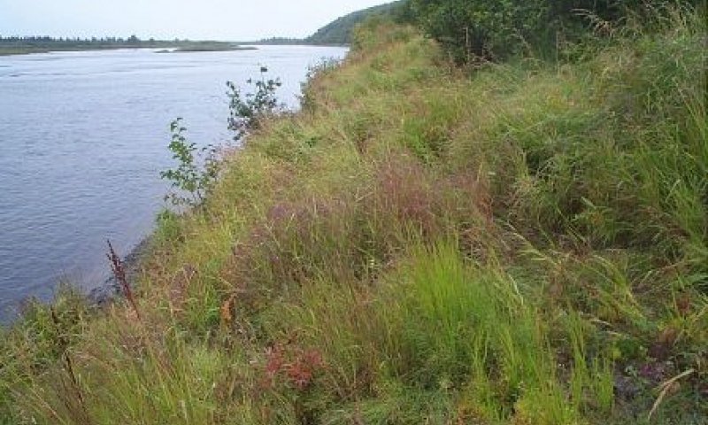
Figure 6. Typical area of community 1.3.
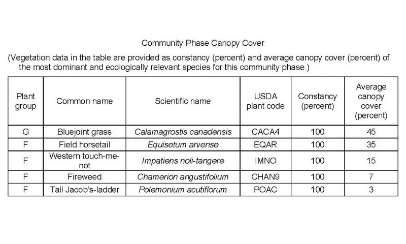
Figure 7. Constancy and canopy cover of plant species in community 1.3.
This early erosional community phase is characterized by a mixed graminoid and forb meadow. Typically, it consists of bluejoint grass (Calamagrostis canadensis), field horsetail (Equisetum arvense), western touch-me-not (Impatiens noli-tangere), and fireweed (Chamerion angustifolium). Other species such as fringed willowherb (Epilobium ciliatum ssp. glandulosum) and colonizing alders (Alnus spp.) may be present. These recently disturbed areas typically support myriad types of ground cover, including mosses and herbaceous litter. Areas of surface rock fragments, bare soil, and surface water also are common.
Note: The vegetation and soils associated with this plant community phase were sampled at one location. Due to the limited data available, personal field observations were used to aid in describing this plant community.
Pathway 1.1a
Community 1.1 to 1.3
Kenai birch-paper birch/Sitka alder-cloudberry/bluejoint grass/horsetails/moss forest
Bluejoint grass/field horsetail–western touch-me-not meadow
Erosion from landslides or windthrow.
These steeply sloping escarpments may be susceptible to landslides, and the medium and tall trees may be susceptible to windthrow. These disturbances can create nonvegetated areas in which fast-growing, pioneer plants may become established. The erosional processes may be induced or further compounded by the wetness of the soils. The time frame for these disturbances is unknown, but windthrow generally depends on a variety of factors, including tree height, rooting depth, and windspeed.
Pathway 1.2a
Community 1.2 to 1.1
Sitka alder/bluejoint grass/field horsetail scrubland
Kenai birch-paper birch/Sitka alder-cloudberry/bluejoint grass/horsetails/moss forest
Natural succession: Normal time and growth without disruptive erosion.
As the effect of the landslides or windthrow subsides, deciduous trees will colonize and reproduce and eventually replace alder as the dominant overstory species. The understory typically will open, allowing for a mix of competitive, commonly hydrophilic shrubs, forbs, and graminoids to colonize and thrive. The period needed for this transition currently is unknown, but it likely depends partially on the rates of colonization and growth of trees. This transition may be slowed temporally and plant colonization may be affected spatially by seepage and runoff.
Pathway 1.3a
Community 1.3 to 1.2
Bluejoint grass/field horsetail–western touch-me-not meadow
Sitka alder/bluejoint grass/field horsetail scrubland
Natural succession: Normal time and growth without disruptive erosion.
Over time, the landform likely will stabilize and organic matter will be added to the soils from senescent colonizers. Nitrogen-fixing alders may colonize, creating a dense overstory sufficient for supporting shade-tolerant forbs and graminoids. The period needed is unknown, but it likely depends partially on the rates of colonization and reproduction of alder and the proximity of seed sources. Runoff and seepage may temporally slow this transition.


