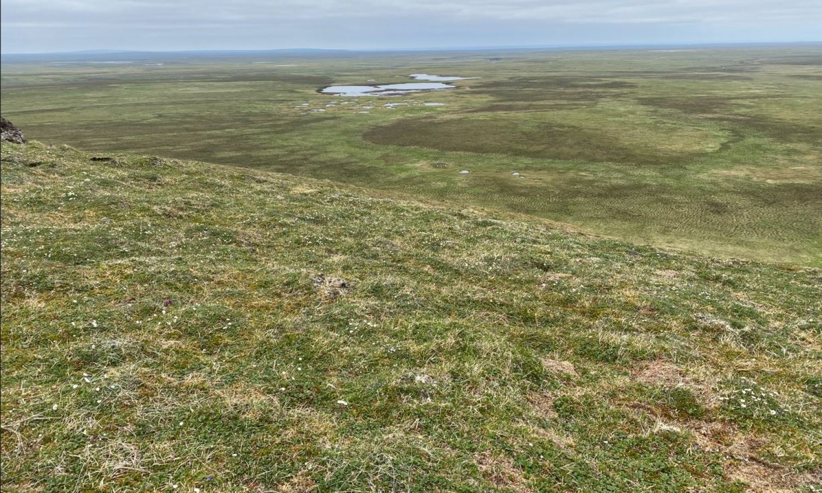
Alpine Dwarf Scrub Silty Slopes


Scenario model
Current ecosystem state
Select a state
Management practices/drivers
Select a transition or restoration pathway
-
Transition T1
Human introduction of reindeer and/or muskox to islands.
More details -
Transition T3
Solifluction results in the formation of a solifluction lobe.
More details -
Restoration pathway R1
Long periods of time after extirpation of human introduced ungulates.
More details -
Transition T2
Solifluction results in the formation of a solifluction lobe
More details -
No transition or restoration pathway between the selected states has been described
Target ecosystem state
Select a state
Description
The historic and current use of introduced ungulates in this MLRA may have altered the potential natural vegetation on these islands. Islands in this MLRA without a history of introduced grazing have reference state vegetation, while islands with introduced herds of reindeer and/or muskox (Nunivak, St. Lawrence, and St. Matthews Islands) have grazing state vegetation.
Currently no data has been collected in areas of this MLRA in reference condition. Future targeted data collection efforts can address whether range in excellent condition within the grazing state is similar to reference state vegetation and these results could dramatically alter this provisional state and transition model.
Submodel
Description
Two plant communities occur within the grazing state and the vegetation differs in large part due to the degree of ungulate use.
The data for this state is based on a mixture of recent field work conducted on Nunivak Island (2022-2023) and historical range surveys conducted on Nunivak Island (Swanson et al. 1986, Kautz et al. 1992). Future work will be required to determine if the vegetation on Nunivak Island represent the vegetation across the grazed islands of this MLRA.
Submodel
Description
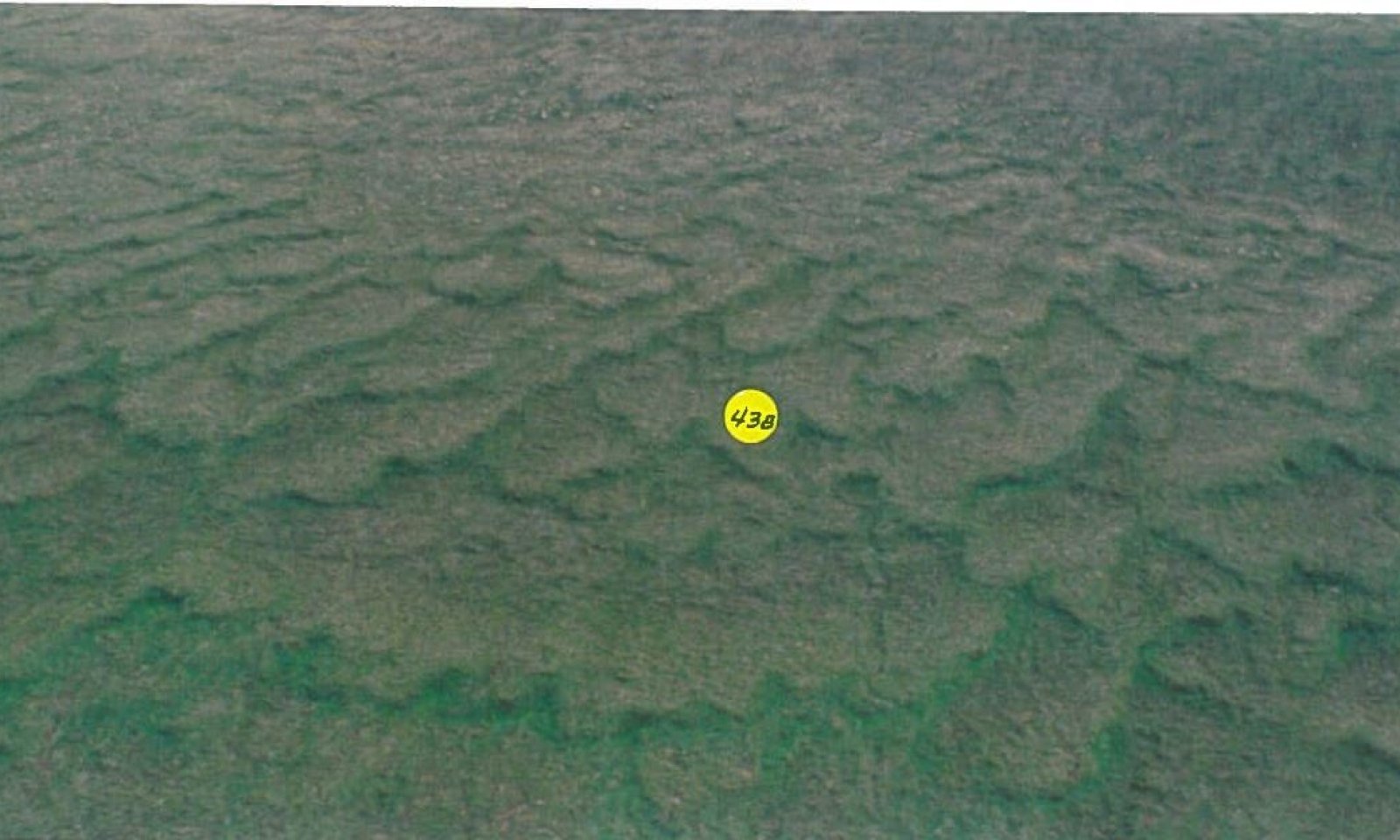
Solifluction is the slow, viscous downslope flow of water-saturated soil (Schoeneberger and Wysocki 2017). This process is most active for this site during spring thaw where the upper band of soil material slips on a seasonally frozen layer. Solifluction is a common process associated with many ecological sites in this area. However, this site can experience solifluction to a degree that results in the formation of solifluction lobes.
A solifluction lobe is an isolated tongue-shaped feature up to 25 meters wide and 150 meters or more long, formed by the rapid solifluction of certain sections of a slope showing variations in gradient. This feature commonly has a steep front and a relatively smooth upper surface (Schoeneberger and Wysocki 2017). Larger solifluction lobes tend to have a distinct mosaic of vegetation, while smaller solifluction lobes do not. The presence of this vegetation mosaic led to the development of an alternate state.
This vegetation mosaic has two distinct communities associated with different positions on or adjacent to the solifluction lobe. The first plant community occurs upslope from the solifluction lobe (community 3.1) and generally resembles the reference state or grazing state potential natural vegetation. The second plant community occurs on the solifluction lobe (community 3.2) , which has a productive stand of shrubs that grow substantially taller compared to the surrounding alpine vegetation. The steep front associated with large solifluction lobes results in comparatively warmer and drier soils. An additional plant community occurs related to continuous grazing of community 3.1.
Submodel
Mechanism
Solifluction results in the formation of a solifluction lobe. This solifluction lobe is large enough to result in a mosaic of vegetation.
Mechanism
Long periods of time after extirpation of human introduced ungulates.
Model keys
Briefcase
Add ecological sites and Major Land Resource Areas to your briefcase by clicking on the briefcase (![]() ) icon wherever it occurs. Drag and drop items to reorder. Cookies are used to store briefcase items between browsing sessions. Because of this, the number of items that can be added to your briefcase is limited, and briefcase items added on one device and browser cannot be accessed from another device or browser. Users who do not wish to place cookies on their devices should not use the briefcase tool. Briefcase cookies serve no other purpose than described here and are deleted whenever browsing history is cleared.
) icon wherever it occurs. Drag and drop items to reorder. Cookies are used to store briefcase items between browsing sessions. Because of this, the number of items that can be added to your briefcase is limited, and briefcase items added on one device and browser cannot be accessed from another device or browser. Users who do not wish to place cookies on their devices should not use the briefcase tool. Briefcase cookies serve no other purpose than described here and are deleted whenever browsing history is cleared.
Ecological sites
Major Land Resource Areas
The Ecosystem Dynamics Interpretive Tool is an information system framework developed by the USDA-ARS Jornada Experimental Range, USDA Natural Resources Conservation Service, and New Mexico State University.