
Natural Resources
Conservation Service
Ecological site R240XY702AK
Alpine Scrub Flood Plain Complex
Last updated: 6/05/2025
Accessed: 04/10/2026
General information
Provisional. A provisional ecological site description has undergone quality control and quality assurance review. It contains a working state and transition model and enough information to identify the ecological site.
MLRA notes
Major Land Resource Area (MLRA): 240X–Nulato Hills-Southern Seward Peninsula Highlands
The Nulato Hills-Southern Seward Peninsula Highlands (MLRA 240X) is in Western Alaska, which describes the mostly treeless zone of discontinuous permafrost in the arctic. This MLRA is approximately 18,500 square miles in size. The terrain is defined by rolling hills, low mountains and river valleys. Flood plains systems are common but generally narrow. This watershed drains into Norton Sound and Bering Sea. Major rivers include the Unalakleet, Koyuk, and Fish Rivers. The area is mostly undeveloped wild land that is sparsely populated. Residents use this remote area primarily for subsistence hunting, fishing, and gathering. Villages are primarily located along the coast and include the two larger municipalities of Nome and Unalakleet, and various other villages such as Koyuk and Saint Michael.
Geology and Soils
This MLRA was mostly unglaciated during the late Pleistocene. Glaciers were limited to upper elevations on the Seward Peninsula. Coastal lowlands are filled with Holocene deposits. Silty eolian deposits mantle coastal areas and the slopes of lower elevation hills and mountains. Flood plains and terraces are built on fluvial deposits. Modified glacial moraines are evident in areas of past glacial activity. Bedrock material is primarily a mix of sedimentary and volcanic rock (USDA, 2022).
This MLRA is in the zone of discontinuous permafrost. Shallow permafrost is most common on coastal plains, gentle footslopes, and organic swales. Permafrost constitutes a root- restrictive layer that perches water and creates poorly drained or poorly drained soils.
Common soil orders include Gelisols that support permafrost and Entisols and Inceptisols which are marked by little to no development. The Gelisols are typically shallow or moderately deep to permafrost, occur on finer to gravelly textured sediments, and are poorly or very poorly drained. Common Gelisol suborders are Histels, Orthels, and Turbels. The Histels have thick accumulations of surface organic material and commonly occur on mounds of plains. The Orthels and Turbels have comparably thinner surface organic material. Turbels show signs of cryoturbation while Orthels do not. Entisols and Inceptisols are common on shallow rocky soils of the alpine and subalpine, as well as scoured flood plain soils. Non-soil areas (rock outcrop, rubble land and beaches) make up approximately five percent of the MLRA surface.
Climate
The climate is a mix of maritime in the summer and continental in the winter, which is a result of sea ice in Norton Sound. Summers are brief and cool summers and winters are long and cold. Mean annual precipitation is 15 to 20 inches at lower elevations, increasing to 20 to 40 inches at higher elevations (USDA, 2022). Mean annual temperatures ranges from 23 to 31 degrees F (SNAP, 2014a).
Vegetation
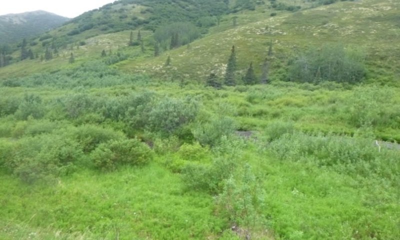
Vegetation is mainly influenced by site and soil characteristics such as temperature-degree days, exposure to wind, soil depth, and soil hydrology. Dwarf scrublands are present across much of the uplands. Lower elevations generally support more developed soils. Well drained soils support tall shrubs. Organic soils support mosses, graminoids and low shrubs. Forests occur on some low mountain slopes and river valleys but are associated with the Yukon-Kuskokwim Highlands (MLRA 230X). Tussock tundra is ubiquitous across much of the poorly drained, low gradient slopes and coastal plains (USDA, 2022).
LRU notes
There are two life zones delineated by plant communities along a temperature gradient driven by elevation. The predominant climate across MLRA 240X is arctic lowlands. Low mean annual air temperatures and a short growing season shape the vegetation across the landscape. The alpine climate zone is generally reserved for elevations above 1,200 feet. Decreased mean annual temperatures at these higher elevations support unique soils and vegetation.
Classification relationships
Alaska Vegetation Classification:
Open low scrub (II.C.2 - level III) / Open low willow scrub (II.C.2.g – level IV)
(Viereck et al., 1992)
BioPhysical Settings:
6817150 – Alaska Arctic Floodplain
(Landfire, 2009)
Circumpolar Arctic Vegetation Map:
Riparian areas – communities 65 & 66
(CAVM Team, 2003)
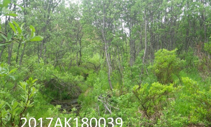
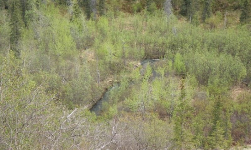
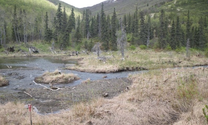
Ecological site concept
• Occurs on arctic flood plains
• This ecological site is on gentle sloped river and stream valleys
• Flooding is the major disturbance affecting vegetation on this site, and it results in two communities in the reference state
• Soils are generally loamy, develop from alluvium and are moderately well to well drained
• The reference plant community is a mixed willow scrubland with graminoids and forbs in the understory
• One alternate state is correlated to beaver dams, and the effects dams have on site hydrology and vegetation
Associated sites
| R240XY731AK |
Subalpine Ericaceous Scrub Loamy Slopes R240XY731AK describes subalpine scrub slopes through which arctic flood plains pass through. |
|---|---|
| R240XY710AK |
Arctic Scrub Wet Drainages R240XY710AK describes boreal wet drainages through which this ecological site is hydrologically linked. |
| F230XY614AK |
Boreal Black Spruce Unfrozen Well Drained Slopes F230XY614AK describes black spruce non-permafrost slope through which this flood plain ecological site passes through. |
Similar sites
| R240XY710AK |
Arctic Scrub Wet Drainages R240XY710AK describes boreal wet drainages. The drainages frequently pond, which also occurs in the beaver-affected alternate state of this ecological site. |
|---|
Table 1. Dominant plant species
| Tree |
Not specified |
|---|---|
| Shrub |
(1) Salix alaxensis |
| Herbaceous |
(1) Calamagrostis canadensis |
Click on box and path labels to scroll to the respective text.
Ecosystem states
| T1A | - | Beaver dam construction |
|---|---|---|
| R2A | - | Beaver dam removal |
State 1 submodel, plant communities
| 1.1a | - | Increase in flood energy |
|---|---|---|
| 1.2a | - | Decrease in flood energy |