Ecological site group R006XG726WA
Stony, Dry Oak
Last updated: 09/21/2023
Accessed: 02/21/2026
Ecological site group description
Key Characteristics
None specified
Provisional. A provisional ecological site description has undergone quality control and quality assurance review. It contains a working state and transition model and enough information to identify the ecological site.
Physiography
Hierarchical Classification
Major Land Resource Area (MLRA): 6 – Cascade Mountains, East Slope
LRU – Common Resource Areas (CRA):
6.6 – Yakima Plateau and Slopes
6.7 – Grand Fir Mixed Forest
6.8 – Oak-Conifer Eastern Cascades-Columbia Foothills
Site Concept Narrative
Diagnostics:
Stony, dry oak is a hot, dry site at the lower edge of conifer forest and woodland. This ecological site occurs at elevations below 3,000 feet, and often on south, east or west aspects. Soils are generally stony, droughty and less than 30 inches in depth.
This site is not considered forest. A tree canopy of 20-30% is a full canopy for this ecological site, which makes this a woodland site, and not a forest type. Stony, dry oak is the hottest and driest woodland habitat. The oak plants on this site can be described as shrubby, scrubby, or scraggly. The Oregon white oak on this site are scattered and patchy.
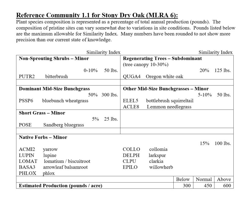
Oak is the only regenerating tree species, on this site. Other shrubs are absent to inconspicuous and the undergrowth is largely bunchgrass and forbs. Oregon white oak, bluebunch wheatgrass, bottlebrush squirreltail and yarrow are the most common species in the reference condition.
Oak and bluebunch wheatgrass dominance are key vegetative indicators.
Here is a site comparison:
• Bitterbrush-bunchgrass with no trees = Stony Foothills ecological site
• Oak-pine-snowberry forest on adjacent river terraces = Oak-pine-snowberry ecological site
• Oak-pine-elk sedge forest on a more moderate site = Oak-pine-elk sedge ecological site
• Oak-wildrye occurs on more moderate sites.
• Ponderosa pine-bitterbrush-bluebunch wheatgrass and ponderosa pine-bluebunch occur on similar sites, but outside the range of oak.
Principle Vegetative drivers:
The rock fragments volume, aspect and soil depth limitations drive the vegetative expression of Stony, dry oak.
Influencing Water Features:
A plant’s ability to grow on a site and overall plant production is determined by soil-water-plant relationships
1. Whether rain and melting snow runs off-site or infiltrates into the soil
2. Whether soil condition remain aerobic or become saturated and become anaerobic
3. Water drainage and how quickly the soil reaches wilting point
With adequate cover of live plants and litter, there are no restrictions on Loamy sites with water infiltrating into the soil. These sites are well drained and are saturated for only a short period.
Physiographic Features:
Most of MLRA 6 is in the Northern and Middle Cascade Mountains. This mountainous area consists of sharp alpine summits with some higher volcanic cones to the west, and lower lying foothills to the east. Strongly sloping mountains and U-shaped valleys are dominant in the north, with eroded basalt plateaus more typical in the south. The East Slope of the Cascades is a transitional area between the moist, rugged Cascade Mountains to the west and the drier, lower lying Columbia Basalt Plateau to the east. MLRA 6 has some of the landforms typical of both mountains and plateaus.
Physiographic Division: Pacific Mountains
Physiographic Province: Cascade-Sierra Mountains
Physiographic Sections: Northern Cascade and Middle Cascade Mountains
Landscapes: Hills, canyons and plateaus
Landform: Summits, shoulders, sideslopes
Elevation: Dominantly 1,000 to 3,000 feet
Central tendency: 1,500 to 2,500 feet
Slope: Total range: 5 to 75 percent
Central tendency: 15 to 50 percent
Aspect: Dominantly on southerly aspect, but occurs on all aspects
Geology:
MLRA 6 consists of Pre-Cretaceous metamorphic rocks cut by younger igneous intrusives. Tilted blocks of marine shale, carbonate, and other sediments occur in the far north, and some younger continental, river-laid sediments occur around Leavenworth, WA. Columbia River basalt is dominant in the southern portion of the state. Alpine glaciation has left remnants of glacial till, debris, and outwash in the northern part of this MLRA.
Climate
The climate across MLRA 6 is characterized by moderately cold, wet winters, and hot, dry summers, with limited precipitation due to the rain shadow effect of the Cascades. The average annual precipitation for most of the East Slope of the Cascades is 16-50 inches. Seventy-five to eighty percent of the precipitation comes late October through March as a mixture of rain and snow. The lowest precipitation occurs along the eastern edge, then increasing with rising elevation to the west. Most of the rainfall occurs as low-intensity, Pacific frontal storms during the winter, spring and fall. Rain turns to snow at the higher elevations. All areas receive snow in winter. Summers are relatively dry. The East Slopes experience greater temperature extremes and receive less precipitation than the west side of the Cascades. The shortest freeze-free periods occur along the western edge and the northern end of this MLRA, which are mountainous. The longest freeze-free periods occur along the Columbia River Gorge.
Mean Annual Precipitation:
Range: 16-30 inches
Central tendency: 18 – 26 inches
Soil moisture regime is xeric
Mean Annual Air Temperature:
Range: 43 to 52 degrees
Central tendency: 46 to 50 degrees
Soil temperature regime is mesic
Frost-free Period (days):
Total range: 80 to 180
Central tendency: 100 to 140
The growing season is mid-March through mid-July.
Soil features
Edaphic:
The Stony, dry oak ecological site commonly occurs with Oregon White Oak-Ponderosa Pine-Elk Sedge-Bitterbrush and Oregon White Oak-Ponderosa Pine-Snowberry ecological sites.
Representative Soil Features:
This ecological site components are dominantly Ultic and Pachic taxonomic subgroups of Haploxerolls great groups of the Mollisols. Soils are dominantly moderately deep and deep. Average available water capacity of about 7.0 inches (17.8 cm) in the 0 to 40 inches (0-100 cm) depth range.
Soil parent material is dominantly mixed loess and colluvium in the upper part of the soil over colluvium and residuum.
The associated soils are Goldendale, Hyprairie and similar soils.
Dominate soil surface is loam to stony ashy silt loam.
Dominant particle-size class is fine-loamy to loamy-skeletal.
Fragments on surface horizon > 3 inches (% Volume):
Minimum: 0
Maximum: 2
Average: 0
Fragments within surface horizon > 3 inches (% Volume):
Minimum: 0
Maximum: 25
Average: 10
Fragments within surface horizon ≤ 3 inches (% Volume):
Minimum: 0
Maximum: 20
Average: 10
Subsurface fragments > 3 inches (% Volume):
Minimum: 5
Maximum: 25
Average: 10
Subsurface fragments ≤ 3 inches (% Volume):
Minimum: 5
Maximum: 35
Average: 20
Drainage Class: Well drained
Water table depth: Greater than 60 inches
Flooding:
Frequency: None
Ponding:
Frequency: None
Saturated Hydraulic Conductivity Class:
0 to 10 inches: Moderately high
10 to 40 inches: Moderately high
Depth to root-restricting feature (inches):
Minimum: 20
Maximum: Greater than 60 inches
Electrical Conductivity (dS/m):
Minimum: 0
Maximum: 3
Average: 0
Sodium Absorption Ratio:
Minimum: 0
Maximum: 3
Average: 0
Calcium Carbonate Equivalent (percent):
Minimum: 0
Maximum: 0
Soil Reaction (pH) (1:1 Water):
0 - 10 inches: 5.6 to 7.3
10 - 40 inches: 5.6 to 7.3
Available Water Capacity (inches, 0 – 40 inches depth):
Minimum: 4.3
Maximum: 8.3
Average: 7.0
Vegetation dynamics
Ecological Dynamics:
Oregon white oak is one of the tree species most tolerant of heat and drought in the northwest. Although widely distributed on the west side of the Cascades, Oregon white oak is limited on the east slope to a relatively small area north and south of the Columbia Gorge. the northernmost stand is separate and occurs on Swauk Creek between Ellensburg and Cle Elum. Cold temperatures seem to be the limiting factor in the northwest distribution of Oregon white oak east of the Cascades.
The key for Oak-bluebunch wheatgrass is greater than 5% bluebunch wheatgrass. Wenatchee National Forest calls Oak-bluebunch wheatgrass “Hot Mesic Shrub-Herb”. Other oak habitats include
Oak-pinegrass-elk sedge which occurs on more moderate sites
Oak-hazel-snowberry occurs on adjacent river terraces
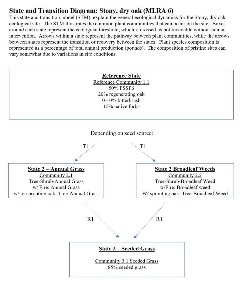
Historical fire frequency is judged to be in the 5-30 -year range, with most being of low intensity. Oregon white oak is very fire tolerant because its foliage is relatively non-flammable and it will re-sprout should the above-ground stem be killed. Lack of fire or altered fire cycles in recent years have led to changes in floristic composition. Fire sensitive species are more common and fuel ladders have developed. Many stands are scrubby as a result of past logging and grazing and are more susceptible to stand-replacement fires. The ability of Oregon white oak to re-sprout after fire or cutting allows it to readily revegetate disturbed sites.
Over the years, Oregon white oak habitats have been heavily grazed by game animals and livestock. Heavy grazing reduces cover of bluebunch wheatgrass and Idaho fescue. The relative density of bunchgrasses to cheatgrass is a rough indication of the amount of past intensive grazing. The open nature of these stands leaves them very susceptible to noxious weeds after heavy grazing or other ground disturbing activity. Introduced grasses and forbs may persist for many years in these open environments.
Grazing pressure:
1. Bluebunch declines, oak increases (bitterbrush may as well) along with unpalatable forbs
2. With continued decline weeds (cheatgrass or noxious weeds) colonize the site
3. Site becomes Oak-bitterbrush-annual grass or noxious weeds
4. With fire becomes annual grass, then with re-sprouting becomes oak-annual grass
Stands of Oregon white oak are very important deer and elk winter ranges that remain clear of snow most of the winter.
Major Land Resource Area
MLRA 006X
Cascade Mountains, Eastern Slope
Stage
Provisional
Contributors
Provisional Site Author: Kevin Guinn Technical Team: R. Fleenor, K. Bomberger, K. Paup-Lefferts
Click on box and path labels to scroll to the respective text.

