Ecological site group R014XG922CA
Clayey Upland
Last updated: 09/07/2023
Accessed: 02/21/2026
Ecological site group description
Key Characteristics
None specified
Provisional. A provisional ecological site description has undergone quality control and quality assurance review. It contains a working state and transition model and enough information to identify the ecological site.
Physiography
This ESG is typically found on complex undulating, rolling to steep uplands with slopes of 5 to 50 percent. Elevations are 25 to 3,000 feet.
Climate
The average annual precipitation in this area is 11 to 53 inches (272 to 1,353 millimeters). The higher amounts of precipitation occur at the higher elevations in the area north of San Francisco. Most of the rainfall occurs as low- or moderate-intensity, Pacific frontal storms during winter. This area is very dry from midspring to midautumn. Snowfall is rare. The average annual temperature is 54 to 61 degrees F (12 to 16 degrees C). The freeze-free period averages 315 days and ranges from 265 to 365 days. It is longest near the coast, and it becomes shorter with elevation.
Soil features
Soils in this ESG soils are deep, well drained soils that formed in colluvium and residuum from ultramafic and serpentine materials and shale. The soils are silty clay and clay textures and clay horizons have slickensides.
Some representative soils include:
Diablo, a fine, smectitic, thermic Aridic Haploxerert
Santerhill, a fine, magnesic, thermic Aridic Haploxererts
Vegetation dynamics
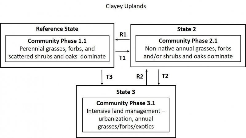
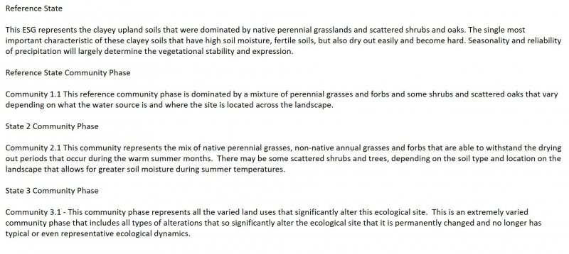
This ESG covers the areas of the valleys in MLRA 14 that were at one time part of a vast complex of oak savannahs, meadows, perennial native grasslands. The urbanized landscape in the valleys within this MLRA that exists today makes it difficult to imagine the natural landscape prior to human development.
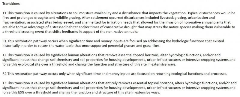
These clayey upland areas that received significant spring water run-on from upslope watershed water or from springtime flooding. Once the area began to be settled, much of this site was drained, leveed, cleared for crops and other agriculture, and urbanized.
As this landscape was de-watered and houses and agriculture took over, the water table for many of these habitats moved deeper and deeper, creating soils that would no longer offer the available soil moisture for many of the plants that had evolved with the hydrologic function of the natural system that no longer existed. These slowly drained clayey soils would have transitioned rather slowly to an altered state with the removal of the yearly groundwater sources, due to higher water holding capacities during most of the growing season. The finer clay textures will harden as they dry out through both drainage and evapotranspiration in the summer months making them less hospitable for many of the native plants and more dominated by annual grasses and forbs, the higher water-holding clays will be slightly more resilient. Annual production will vary depending on the soil texture and proximity to groundwater sources.
Historically, this site may have looked similar to the CWHR native perennial grasslands and/or oak savannahs, however with the introduction of non-native annual grasses and the impacts from fragmentation, extensive agriculture, continued de-watering, and human alterations such as homes and roads, this site now reflects a lower producing, dry, annual grassland.
Currently, where this site is not under cultivation or urban developments, it is dominated by non-native annual grasses and oaks. These include wild oats, soft chess, ripgut brome, red brome, wild barley, and foxtail fescue. Common forbs include broadleaf filaree, redstem filaree, turkey mullein, true clovers, bur clover, popcorn flower, and many others. Perennial grasses will be found in moist, lightly grazed, or relic prairie areas. Species composition is also related to water availability with greater amounts of relic perennial grasses in areas of greater precipitation or soil moisture.
Information from:
John G. Kie
California Wildlife Habitat Relationships System
California Department of Fish and Game
California Interagency Wildlife Task Group
Major Land Resource Area
MLRA 014X
Central California Coastal Valleys
Stage
Provisional
Click on box and path labels to scroll to the respective text.


