Ecological site group F015XY001CAESG
Riparian
Last updated: 09/07/2023
Accessed: 02/21/2026
Ecological site group description
Key Characteristics
- located on riparian areas
Provisional. A provisional ecological site description has undergone quality control and quality assurance review. It contains a working state and transition model and enough information to identify the ecological site.
Physiography
The watershed geomorphology and physical processes form the basis for understanding the spatial extent of the riparian forests, which includes the valley shape, hillslope processes, fluvial processes, soil processes, and hydrologic processes.
This site is found on floodplains, valley bottoms, and alluvial terraces on variable slopes.
Climate
The average annual precipitation in this area is typically 11 to 39 inches (280 to 1000 millimeters) . Some areas can get as low as 6 inches (150 millimeters), while the areas at higher elevations can reach up to 88 inches (2235 millimeters) on average. Snowfall is common in the northern half of the part north of San Francisco and rare elsewhere. Precipitation is evenly distributed throughout fall, winter, and spring but is very low in summer. Coastal areas receive some moisture from fog in summer. Most of the rainfall occurs as low- or moderate-intensity, Pacific frontal storms during the period October to May. The average annual temperature is 52 to 65 degrees F (11 to 18 degrees C), decreasing from south to north. The freeze-free period averages 275 days and ranges from 180 to 365 days, decreasing in length with elevation and from south to north.
Soil features
Soils in this ESG are typically very deep, well drained soils formed in material weathered from graywacke, shale, siltstone, sandstone or formed in alluvium from mixed rock sources.
The most typical soils represented include:
Flaskan, a fine-loamy, mixed, superactive, thermic Typic Argixerolls
Yorktree, a fine, mixed, superactive, mesic Ultic Argixerolls
Vegetation dynamics
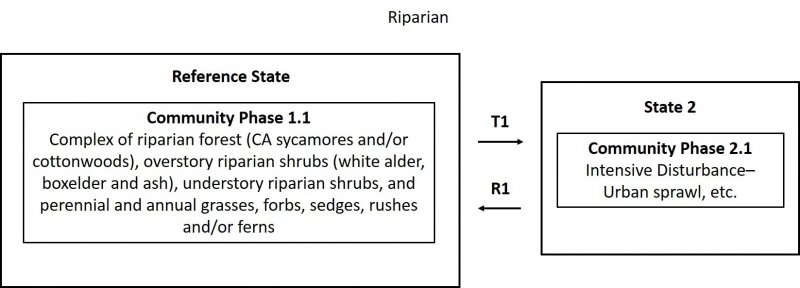
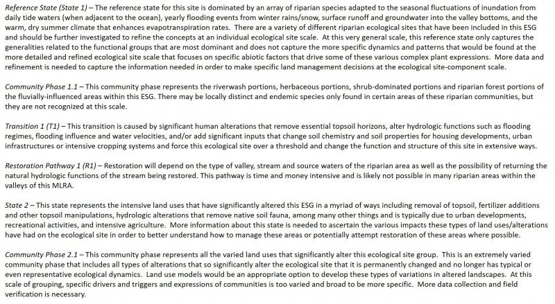
This ESG is found on flood plains and will reflect vegetation dynamics driven mainly by fluvial processes and hydrologic dynamics. Riparian vegetation is most common on these flood plains represent the low-gradient areas within this LRU that are heavily influenced by fluvial processes. This ESG is composed of a variety of different riverine expressions/ecological sites and will require more detailed field investigations in order to refine the site concepts and likely develop several new sites that are correlated to similar geologic structure and processes, hydrologic regimes, and vegetation characteristics. This concept captures variety of typical riparian vegetation expressions and ranges from mostly herbs and shrubs to shrubs and trees that are found in riverine systems that are primarily larger rivers at the end of the watershed and broad open valleys. The band of riparian vegetation may be broader or narrower depending on where in the MLRA it is found.
Abiotic Factors/Primary Disturbance
Riparian forests are a complex interaction of many various physical and biologic factors, including function of valley morphology, physical processes, vegetative legacies, and life history strategies. The watershed geomorphology and physical processes form the basis for understanding the spatial extent of the riparian forests, which includes the valley shape, hillslope processes, fluvial processes, soil processes, and hydrologic processes. Soil development within alluvial environments is highly variable. Frequent erosional and depositional disturbances from flooding create a complex mosaic of soil conditions in the active floodplain that fundamentally influences vegetation colonization and establishment. Well-drained soil or recently deposited mineral alluvium may be found adjacent to very poorly drained organic soils in abandoned high-flow channels. This variability in soil conditions is a major factor in maintaining the high plant diversity typical of riparian ecological sites.
The disturbances that drive this ecological site concept are dependent on the type, frequency, predictability, extent, magnitude, and timing of the disturbance. The fluvial processes that are dominant in this riparian ecological site concept include stream power, basal shear stress, channel migration, and sediment deposition. The characteristic vegetation pattern of these low-gradient valleys is maintained by fluvial disturbances and geomorphology. The amount of force exerted on the channel bed and vegetation growing in the active channel and floodplain during a flood is a product of fluid density, gravitational acceleration, flow depth, and water surface slope.
Sourced from:
BARBOUR, M., KEELER-WOLF, T., & SCHOENHERR, A. (Eds.). (2007). Terrestrial Vegetation of California, 3rd Edition. University of California Press. Retrieved November 10, 2020, from http://www.jstor.org/stable/10.1525/j.ctt1pnqfd.
Major Land Resource Area
MLRA 015X
Central California Coast Range
Stage
Provisional
Contributors
Kendra Moseley
Darren Pinnegar
Click on box and path labels to scroll to the respective text.

