Ecological site group R015XY008CAESG
Hills <20"ppt
Last updated: 09/07/2023
Accessed: 02/21/2026
Ecological site group description
Key Characteristics
- located on hills
- <20" ppt
Provisional. A provisional ecological site description has undergone quality control and quality assurance review. It contains a working state and transition model and enough information to identify the ecological site.
Physiography
This ESG is typically found on narrow divides, hills, and uplands and have slopes of 2 to 75 percent. Elevations typically range from 100 to 2000 feet.
Climate
The average annual precipitation in this area ranges from 6 to 20 inches (150 to 500 millimeters). Precipitation is evenly distributed throughout fall, winter, and spring but is very low in summer. Coastal areas receive some moisture from fog in summer. Most of the rainfall occurs as low- or moderate-intensity, Pacific frontal storms during the period October to May. The average annual temperature is 52 to 65 degrees F (11 to 18 degrees C), decreasing from south to north. The freeze-free period averages 275 days and ranges from 180 to 365 days, decreasing in length with elevation and from south to north.
Soil features
Soils in this ESG consist mainly of shallow to moderately deep, well drained to somewhat excessively drained soils that formed in material weathered from hard, fractured diatomaceous shale and material weathered from white shale containing some ash, and some siliceous and diatomaceous material.
The soils that represent this ESG include:
Lopez, a loamy-skeletal, mixed, superactive, thermic Lithic Ultic Haploxerolls
Santa Lucia, a clayey-skeletal, mixed, superactive, thermic Pachic Ultic Haploxerolls
Shedd, a fine-silty, mixed, superactive, calcareous, thermic Typic Xerorthents
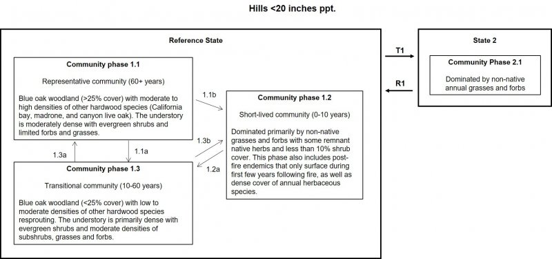
Vegetation dynamics
This ESG covers the thermic (warm) areas of the hills and uplands that receive less than 20 inches of precipitation each year in MLRA 15 that were at one time part of a vast complex of oak woodlands, chaparral, and perennial native grasslands. The fragmented and urbanized landscape in these low elevation foothill terraces within this MLRA that exists today makes it difficult to imagine the natural landscape prior to human development.
Blue oak woodlands are usually associated with warmer, rocky, infertile, well-drained soils from a variety of parent materials. Blue oaks are well adapted to dry, hilly terrain where the water table is usually unavailable. The climate is Mediterranean, with mild wet winters and hot dry summers. Climatic extremes are relatively great in these woodlands, because they have a considerable geographic and elevational range.
Generally, these woodlands have an overstory of scattered trees, although the canopy can be nearly closed on better quality sites. The density of blue oaks on slopes with shallow soils is directly related to water stress. The canopy is dominated by broad-leaved trees 5 to 15 m (16 to 50 ft) tall, commonly forming open savanna-like stands on dry ridges and gentle slopes. Blue oaks may reach 25 m (82 ft) in height; the tallest tree, found in Alameda County, measured 28.7 m (94 ft) high and had a crown spread of 14.6 m (48 ft). Shrubs are often present but rarely extensive, often occurring on rock outcrops. Typical understory is composed of an extension of Annual Grassland vegetation.
Blue oak is the dominant species, comprising 85 to 100 percent of the trees present. Common associates in the canopy are coast live oak in the Coast Range, interior live oak in the Sierra Nevada, valley oak where deep soil has formed, and western juniper in the Cascade Range. In the Tehachapi and Paiute Ranges in Kern County, this habitat mixes with species from east of the mountains California juniper and single-leaf pinyon. In interior sections of the southern Coast Range, as in San Luis Obispo County, it mixes with California juniper. Associated shrub species include poison-oak, California coffeeberry, buckbrush, redberry, California buckeye, and manzanita spp. The ground cover is comprised mainly of annuals, such as brome grass, wild oats, foxtail, needlegrass, filaree, fiddeneck, and others.
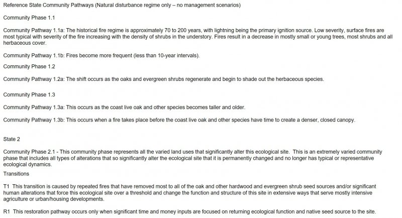
Details of successional trends in this habitat type are poorly known. Succession presumably proceeds directly from annual grasslands to tree stages. Most stands of BOW exist as medium or large tree stages with few or no young blue oaks present. Therefore, only structural classes 3-5:S-D are likely to be found. Few areas can be found in California where successful recruitment of blue oaks has occurred since the turn of the century. This may be due to changes in land use; increased consumption or damage of acorns and seedlings by insects, livestock, and native animals; competition between seedlings and introduced annuals for available soil nutrients and moisture; and the absence of appropriate climatic conditions. Where germination of acorns occurs, survival and growth of the seedlings typically fail. Probably in the drier savanna-like stands, the grassland openings will simply become larger as older trees die. Live oaks may replace deciduous oaks in some areas, because their seedlings are more browse resistant. Many authorities question whether conditions will ever again support the recruitment of blue oaks needed to maintain these important woodlands.
Valid generalizations about the duration of various successional stages leading to mature stands of BOW are not possible, because adequate quantitative studies have never been done. The successional sequence probably takes at least 50 years, even on good sites. Blue oaks are relatively slow-growing, long-lived trees. Large blue oaks range in age from 153 to 390 years. Estimation of tree age based on dbh measurements is risky, however, because the dbh relationship varies tremendously depending on site quality. Moreover, height growth is extremely slow or even ceases after trees reach 65 cm (26 in) in dbh.
Information from:
California Wildlife Habitat Relationships System
California Department of Fish and Game
California Interagency Wildlife Task Group
Lyman V. Ritter
Major Land Resource Area
MLRA 015X
Central California Coast Range
Stage
Provisional
Click on box and path labels to scroll to the respective text.

