Ecological site group R017XY901CAESG
Clayey Basin Group
Last updated: 06/03/2024
Accessed: 02/21/2026
Ecological site group description
Key Characteristics
- Basin Landform
- MAP ≥ 10"
- Basin Landform
- MAP <10"
- pH < 8.4
Provisional. A provisional ecological site description has undergone quality control and quality assurance review. It contains a working state and transition model and enough information to identify the ecological site.
Physiography
This site group occurs in all basin and backswamp landforms within the MLRA. They generally occupy the lowest position on the landscape. These low lying sites historically received supplemental water during storms and periods of high stream flow.
Climate
The average annual precipitation is 5 to 12 inches (125 to 305 millimeters) in the San Joaquin Valley. The Tulare Basin, at the southern end of this MLRA, typically receives less than 6 inches (150 millimeters) of rainfall per year. The average annual precipitation is 12 to 30 inches (305 to 760 millimeters) in most of the Sacramento Valley.
Summers are long, hot, and dry, and winters are cool and rainy. Most of the rainfall occurs as low or moderate intensity, Pacific frontal storms from October to May. Snow is very rare in this MLRA but has occurred in the Sacramento Valley from Sacramento to points farther north. The average annual temperature is 59 to 67 degrees F (15 to 20 degrees C), decreasing from south to north. The freeze-free period averages 325 days and ranges from 280 to 365 days, decreasing in length with elevation and from south to north.
Soil features
The soils associated with this site group are high in clay with a texture of fine loamy or finer and are generally greater than 72" to a root restrictive layer. Impaired drainage and hydric soil properties are also common to these sites.
Taxonomically these site are predominantly Vertisols, though Mollisols, Alfisols and Inceptisols are also possible.
Vegetation dynamics
These sites were classified by Kuchler as tule marsh on the PNV map, and the vegetation falls within either the CNPS Schoenoplectus acutus Alliance or the Typha Alliance.
This site has a single layered vegetation structure lacking trees or woody shrubs. The dominant vegetation is herbaceous graminoids 5-8’ tall principally hardstem bulrush (Schoenoplectus acutus) cattail (Typha latifolia) and California bulrush (Schoenoplectus californicus). The plants are adapted to anaerobic soil conditions and standing water from a few centimeters to 1.5 meters in depth. They are rhizomatous perennials and well adapted to most disturbances. They are capable of forming large clonal monocultures covering acres of land as long as soil moisture conditions are suitable.
This vegetation community is extremely stable over long periods of time. The community is fire adapted and resprouts after fire and some native tribes managed freshwater marsh landscapes by burning to encourage new growth (Anderson, 2005). The plants also reestablish from seedbank after other disturbances.
The ecotone between this site and upland sites has greater diversity of herbaceous plants in the Cypreraceae family. This community is susceptible to disturbance by salinization from agricultural run off or the concentration of salts from pumped ground water which causes the freshwater species to be replaced by more salt tolerant species, such as saltgrass (Distichlis spicata). This transition takes place because the salt interferes with the ability of many plants roots to take up water and critical soil nutrients. Seedlings are particularly sensitive to salt so the plant community becomes unable to sustain itself. The threshold is crossed when the salinity of the root zone exceeds the tolerance of various rush and sedge species. An Ece of 4.0 dS/m is the cutoff used to distinguish moderately saline tolerant plants from moderately saline sensitive plants and an Ece of 4.0 dS/m distinguishes moderately saline tolerant species from saline tolerant species (Warrence et al., 2003).
The principal disturbance that causes a transition to new state is a disruption of hydrologic connectivity which reduces the water at the site. A study conducted in another region showed that 100% of cattail died on sites kept dry for two years, (Nelson and Dietz 1966) though bulrush has been shown to survive longer (Esser, 1995). Federal Policy during the late 1800s and early 1900s encouraged draining these sites for agriculture and the construction of levee systems and regional water projects during the second half of the 20th century changed the region’s hydrology drastically.
California has lost 91% of its original wetlands (Dahl, 1990) and in MLRAs 17 the vast majority of these wetland sites have been converted either to agricultural or urban use (Chico State GIC, 2003). When converted to agriculture these sites are commonly used to grow rice in the Sacramento Valley and cotton, tomatoes and safflower in the San Joaquin Valley. BMPs allow some ecological functions to continue on agricultural land, most notably bird habitat.
At this point in time passive restoration is extremely unlikely, but intensive restoration practices that involve restoring hydrologic connectivity, such as the breaching of levees along the Cosumnes River, or simulating the natural hydrology through irrigation have been successful.
References/Citations:
Anderson, K. 2013. Tending the wild: Native American knowledge and the management of California's natural resources. Berkeley, California, University of California Press.
Dahl, T E. 1990. Wetlands losses in the United States, 1780's to 1980's. Report to the Congress. United States.
Esser, Lora L. 1995. Schoenoplectus acutus. In: Fire Effects Information System, [Online]. U.S. Department of Agriculture, Forest Service, Rocky Mountain Research Station, Fire Sciences Laboratory (Producer). Available: https://www.fs.usda.gov/database/feis/plants/graminoid/schacu/all.html [2023, December 12].
Keeler-Wolf, T., J.O. Sawyer, and J. Evans. 2009. A Manual of California Vegetation. Edition, 2. California Native Plant Society Press.
Nelson, N.F. and R.H. Dietz. 1966. Cattail Control Methods in Utah. Utah Department of Fish and Game Publication. 66:1-31.
The Central Valley Historic Mapping Project. 2003. California State University, Chico Department of Geography and Planning and Geographic Information Center. http://www.waterboards.ca.gov/waterrights/water_issues/programs/bay_delta/docs/cmnt081712/sldmwa/csuc.
Warrence, N.J., Pearson, K. E., and J.W. Bauder. 2003. The Basics of Salinity and Sodicity Effects on Soil Physical Properties Information. Highlights for the General Public
http://waterquality.montana.edu/docs/methane/basics_highlights.pdf.
Major Land Resource Area
MLRA 017X
Sacramento and San Joaquin Valleys
Stage
Provisional
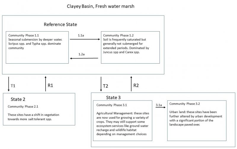
Click on box and path labels to scroll to the respective text.
| T1 | - | Increased salinity |
|---|---|---|
| T2 | - | Urbanization/Agricultural Conversion |
| R1 | - | Saline Management |
| T3 | - | Urbanization/Agricultural Conversion |
| R1 | - | Restoration of Hydrology |
| R3 | - | Hydrology Restored but Saline Unmanaged |
State 1 submodel, plant communities
| 1.1a | - | Change in microtopography |
|---|---|---|
| 1.2a | - | Change in microtopography |


