Ecological site group R019XG904CA
Dunes
Last updated: 07/05/2023
Accessed: 02/21/2026
Ecological site group description
Key Characteristics
- located on sand dunes
Provisional. A provisional ecological site description has undergone quality control and quality assurance review. It contains a working state and transition model and enough information to identify the ecological site.
Physiography
This ESG is found on dunes with varied slopes from sea level to 180 feet elevation.
Climate
The average annual precipitation of this MLRA covers a diverse landscape of valleys and mountains and can range anywhere from 8 to 53 inches (215 to 1,354 millimeters), increasing with elevation. Most of the rainfall occurs as low- or moderate-intensity, Pacific frontal storms during winter. Rain can turn to snow at the higher elevations. A little snow may fall in winter, but it does not last. Summers are dry, but fog provides some moisture along the coast. The average annual temperature is 38 to 67 degrees F (3 to 19 degrees C). The freeze-free period averages 310 days in the valleys, 245 days in the mountains, and ranges from 125 to 365 days along the coast. It decreases in length with elevation. The longest freeze-free period occurs at the lower elevations along the western edge of the area.
Soil features
The soils of this ESG are primarily coarse sands composed primarily of eolian sands and alluvium. They are Typic or Lamellic Xeropsamments.
Vegetation dynamics
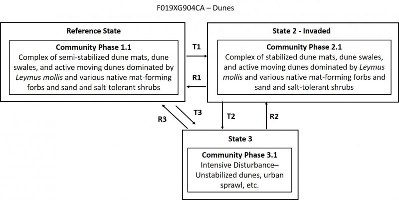
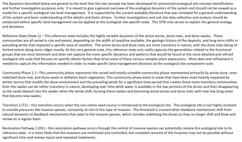
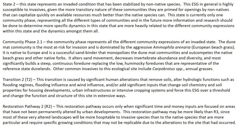
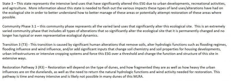
Beach dunes represent the more rapidly changing to older, more stabilized areas directly adjacent to the beaches. They consist of actively moving to well vegetated dunes that are all oriented parallel to the prevailing winds. Many of the older, more stabilized dunes covered in coastal scrub are being transitioned back to actively moving, poorly vegetated dunelands due to changing winds and human alterations and land uses. The extent of this ESG stretches from the back side of the foredunes to the edge of the back dunes. This ESG covers a wide variety of dune dynamics and expressions that may need to be further refined to better represent dynamics on a smaller, more ecologically specific scale. For the purposes of this concept, however, all that variation is lumped into one site concept.
Abiotic Factors/Primary Disturbances
Salt spray, soil salinity, sea-water immersion and sand movement are the most critical abiotic factors for this ESG, primarily in the context of geologic processes and coastline water and wind currents. The salt spray gradient is a function of wind speed, distance from the tide line, height above the ground, and microtopography. Hypertrophy (succulence) accounts for the ability of dicots to withstand salt spray, and grasses that lack this ability, rely on a thick cuticle instead. Salt spray tolerance dictates the species composition that dominates the different areas of this ecological site, but also impacts the structure of the vegetation expression as well. Although beach species are not obligate halophytes, they are tolerant of soil salinity and occasional seawater immersion. Germination and establishment phases of most beach species is when they are the most vulnerable to the soil salinity, and therefore depend on times that seawater immersion and impacts from salt water are minimal until after full establishment.
Water deposition, onshore winds, desiccation, nutrient limitations, and sand burial are the most important disturbances that naturally drive the dynamics of this ecological site concept. Adaptations to sand burial are key adaptations for vegetation in this ecological site, developing larger, heavier seeds that have the ability to emerge from much greater depths once germinated. These species have also adapted to planting themselves deeper in the sands to take advantage of higher soil moisture content and protection from the wind/sea salt spray. Other adaptations include plant morphologies and canopy densities. Different accumulations of sands occur with different plant canopies, for example plants with intermediate canopy densities with loose, cylindrical silhouettes cause a decrease in wind velocities within the plant canopy leading to accretion of fine sands and the formation of hummocks typical of this ecological site.
Desiccation is a major stressor to this ecological site, namely from intense solar radiation and evapotranspiration, seasonal drought, and low water-holding capacities of the sands typical of this ecological site. The species that dominate this ecological site are adapted to these conditions, using various rooting strategies, leaf morphologies that can withstand high levels of solar radiation, high light intensities for photosynthesis, and wind desiccation, and root and shoot strategies to ameliorate the low-fertility soil conditions.
Dune morphology begins when beaches with vegetation create shadow dunes or beach mounds. These shadow dunes occur when a plant causes wind to be deflected, slowing its speed and dropping sand particles into an elongated tongue of sand in the lee of obstacles. Changes in wind direction result in accumulations on all sides and the formation of a beach mound. These can be easily blown out by wind gusts or winter waves. However, when they are built on relatively wide areas of beach, a foredune can develop. A foredune is a vegetated ridge of sand parallel to the beach, rising above the ordinary high tides. These foredunes support greater species richness and plant cover than the upper beach, but fewer species that are found just inland on dune ridges. These incipient shadow dunes and the briefly stabilized foredunes are a part of the other ecological site, R004BA200CA Beaches, which captures the areas of the coastline that are more rapidly changing and consistently impacted by seasonal storms and weather events, shifting the site back and forth between unvegetated beaches to reasonably stabilized beach foredunes only. Anything further away from the winter storm high tide marks that can develop into more stabilized, well vegetated sand dunes are a part of this ESG.
Blowouts that occur in a continuous foredune may result in incipient parabola dunes that later stabilize with vegetation, becoming relatively narrow dune ridges. Ridges alternate with depressions classified as dune swales when they are deep enough to support distinct vegetation and can become classified as deflation basins that are poorly drained and support a distinct ecological site, R004BA206CA Deflation Basins site. Where large areas of mobile sand occur in combination with a wide receptive area and unidirectional winds, transverse dunes form. Crests of these dunes are sinuous, oriented perpendicular to wind direction, and of variable length. These transverse dunes form during low sea levels with abundant sand supply from prograding shorelines and the exposed continental shelf. These dunes move too rapidly to support all but transient vegetation and they may even become superimposed over the large-scale parabola dunes that are formed in areas of stabilized vegetation. These transverse dunes, parabola dunes, and large areas of sand sheets make up the active dune portions of this ecological site concept. In the stabilized, vegetated back dunes, older ridges and stabilized parabolas support forest dune vegetation and troughs support swale vegetation or deflation basin vegetation. This dune ecological site may need to be divided into more ecological site concepts based on more locally specific site dynamics and abiotic factors, but at this time these dynamics are all included in one ESG.
Information taken primarily from Barbour et al, 2007. Terrestrial Vegetation.
Major Land Resource Area
MLRA 019X
Southern California Coastal Plains and Mountains
Subclasses
Correlated Map Unit Components
23477366, 23477457, 22666458, 22666328, 22643346, 22643348, 22669126, 22669204, 22669213, 22668948, 22668376, 22669137, 22669239, 22669145, 22668979, 22668415, 22668984, 22668690, 22669017, 22669013, 22668205, 22668206, 22670492, 22670669, 22670698, 22670931, 22670933, 22670934, 22670970, 22670971, 22670972, 22671183, 22671182, 22671528, 22671530
Stage
Provisional
Contributors
Curtis Talbot
Click on box and path labels to scroll to the respective text.


