Ecological site group R019XG905CA
Riparian
Last updated: 07/06/2023
Accessed: 02/21/2026
Ecological site group description
Key Characteristics
- located in riparian areas
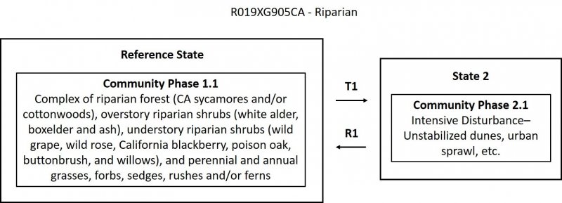
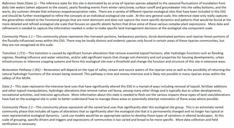
Provisional. A provisional ecological site description has undergone quality control and quality assurance review. It contains a working state and transition model and enough information to identify the ecological site.
Physiography
The watershed geomorphology and physical processes form the basis for understanding the spatial extent of the riparian forests, which includes the valley shape, hillslope processes, fluvial processes, soil processes, and hydrologic processes.
This ESG is typically found in drainageways, washes, stream channels, and stream terraces. Slopes are varied and elevations vary significantly from sea level to over 7000 ft.
Climate
The average annual precipitation of this MLRA covers a diverse landscape of valleys and mountains and can range anywhere from 8 to 53 inches (215 to 1,354 millimeters), increasing with elevation. Most of the rainfall occurs as low- or moderate-intensity, Pacific frontal storms during winter. Rain can turn to snow at the higher elevations. A little snow may fall in winter, but it does not last. Summers are dry, but fog provides some moisture along the coast. The average annual temperature is 38 to 67 degrees F (3 to 19 degrees C). The freeze-free period averages 310 days in the valleys, 245 days in the mountains, and ranges from 125 to 365 days along the coast. It decreases in length with elevation. The longest freeze-free period occurs at the lower elevations along the western edge of the area.
Soil features
Soil development within alluvial environments is highly variable. Frequent erosional and depositional disturbances from flooding create a complex mosaic of soil conditions in the active floodplain that fundamentally influences vegetation colonization and establishment. Well-drained soil or recently deposited mineral alluvium may be found adjacent to very poorly drained organic soils in abandoned high-flow channels. This variability in soil conditions is a major factor in maintaining the high plant diversity typical of riparian ecological sites.
Soils representative of this ESG include Soboba, Riverwash, Loamy alluvial land, Psamments, Fluvents, and Aquents.
Vegetation dynamics
Riparian areas represent the low-gradient areas within this MLRA that are heavily influenced by fluvial processes. This provisional ecological site concept is composed of a variety of different riverine expressions/ecological sites and will require more detailed field investigations in order to refine the site concepts and likely develop several new sites that are correlated to similar geologic structure and processes, hydrologic regimes, and vegetation characteristics. This ecological site concept captures variety of typical riparian vegetation expressions and ranges from mostly herbs and shrubs to shrubs and trees that are found in riverine systems that are primarily larger rivers at the end of the watershed and broad open valleys, often significantly influenced by ocean tides. The band of riparian vegetation may be broader or narrower depending on where in the MLRA it is found and the daily tidal influences. These riparian sites in the valleys will generally be larger, low-velocity stream orders, such as Rosgen C/D or B channels with smaller, finer bedding sediments—whereas most, if not all, of the riparian stream orders in the mountains are typically more A or B channel types with larger bedding sediments.
Abiotic Factors/Primary Disturbance
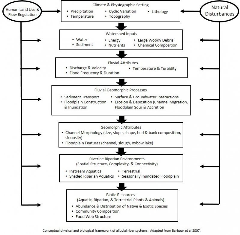
Riparian forests are a complex interaction of many various physical and biologic factors, including function of valley morphology, physical processes, vegetative legacies, and life history strategies.
Coastal fog, wind, salt spray, and daily changes in tides are also major factors that define this ecological site from other riparian ecological sites in other MLRAs and LRUs. Windthrow and wind-breakage are common during winter storms and open the canopy creating more diversity in the understory.
The disturbances that drive this ESG are dependent on the type, frequency, predictability, extent, magnitude, and timing of the disturbance. The fluvial processes that are dominant in this riparian ecological site concept include stream power, basal shear stress, channel migration, and sediment deposition. The characteristic vegetation pattern of these low-gradient valleys is maintained by fluvial disturbances and geomorphology. The amount of force exerted on the channel bed and vegetation growing in the active channel and floodplain during a flood is a product of fluid density, gravitational acceleration, flow depth, and water surface slope.
Major Land Resource Area
MLRA 019X
Southern California Coastal Plains and Mountains
Subclasses
Correlated Map Unit Components
23482294, 23477433, 23477592, 22665572, 23237142, 22665883, 22665799, 22666243, 22666023, 22666024, 22643219, 22668858, 22668776, 22588151, 22671551, 22670945, 22672934, 22673561, 22673560, 22673670
Stage
Provisional
Contributors
Curtis Talbot
Click on box and path labels to scroll to the respective text.


