Ecological site group R019XG912CA
Sandy Fan
Last updated: 07/06/2023
Accessed: 02/21/2026
Ecological site group description
Key Characteristics
- located on alluvial fans
- sandy texture
Provisional. A provisional ecological site description has undergone quality control and quality assurance review. It contains a working state and transition model and enough information to identify the ecological site.
Physiography
This ESG encompasses a broad variety of grass-shrub types that are found on alluvial fans with loamy soils. Elevations in the valleys and foothills range from 100 to 3000 feet, and in the mountains above 3000 feet. Slopes range from 0 to 50%, but much of the concept is under 15% slopes.
Climate
The average annual precipitation covers a diverse landscape of valleys and mountains and can range anywhere from 8 to 53 inches (215 to 1,354 millimeters), increasing with elevation. Most of the rainfall occurs as low- or moderate-intensity, Pacific frontal storms during winter. Rain can turn to snow at the higher elevations. A little snow may fall in winter, but it does not last. Summers are dry, but fog provides some moisture along the coast. The average annual temperature is 38 to 67 degrees F (3 to 19 degrees C). The freeze-free period averages 310 days in the valleys, 245 days in the mountains, and ranges from 125 to 365 days along the coast. It decreases in length with elevation. The longest freeze-free period occurs at the lower elevations along the western edge of the area.
Soil features
The soils in the lower elevations range from coarse sandy loams, sandy loams, very fine sandy loams and loams that are mostly moderately deep to very deep over bedrock. Some of the soils are gravelly or stony or are intermixed with rock outcrop. The bulk of the soils are moderately well to somewhat excessively well drained and have a moderate to high water holding capacity. Soils in the above 3000 ft elevations are similar with coarse sandy loams, fine sandy loams, sandy loams and loams that are mostly moderately deep to very deep. Some are gravelly, cobbly, or stony or intermixed with rock outcrops. The bulk of the soils are moderately well to somewhat excessively well drained and have a moderately low to high water holding capacity.
Vegetation dynamics
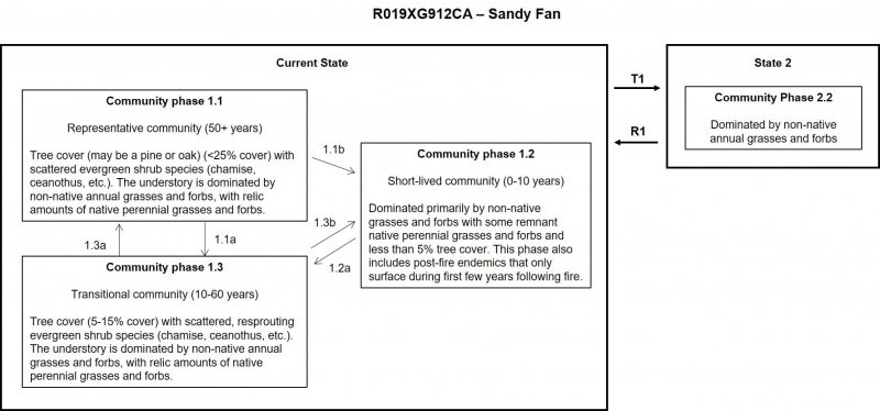
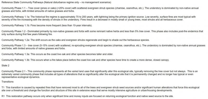
The vegetation that dominates this ESG below 3000 ft. is generally a mix of non-native annual grasslands or scattered to dense shrubs (chamise, ceanothus, California sagebrush, black sage, and/or Eastern Mojave buckwheat). And above 3000 ft. tends to be more of a dynamic of non-native annual grasslands, a shrub (chamise, ceanothus, etc.) community and an open tree (pines or oaks) community.
Major Land Resource Area
MLRA 019X
Southern California Coastal Plains and Mountains
Subclasses
- R019XD012CA–SANDY
- R019XD026CA–SANDY WEST
- R019XD027CA–SANDY EAST
- R019XD029CA–LOAMY
- R019XD030CA–WET MEADOW
- R019XD033CA–LOAMY UPLANDS
- R019XD035CA–SANDY
- R019XD060CA–SHALLOW LOAMY
- R019XD061CA–CLAYPAN
- R019XD065CA–SANDY 9-20"
- R019XD069CA–SANDY ALLUVIAL
- R019XD070CA–SANDY BASIN
- R019XD925CA–LOAMY EAST
- R019XD935CA–COARSE SANDY
- R019XD964CA–LOAMY 9-20"
- R019XE003CA–COARSE LOAMY
- R019XE024CA–LOAMY 9-20"
- R019XG912CA–Sandy Fan
- R019XI105CA–Deep slopes 13-24" p.z.
Correlated Map Unit Components
23481728, 23481775, 23481802, 23481805, 23481808, 23481876, 23481882, 23481883, 23481887, 23481972, 23481978, 23481983, 23482125, 23482319, 23482321, 23482325, 23482329, 23482673, 23482676, 23482358, 23482365, 23482368, 23482370, 23482684, 23482378, 23482385, 23482388, 23482390, 23482396, 23482473, 23482512, 23482518, 23482521, 22642402, 22642399, 22642407, 23477440, 23477538, 22665169, 22665505, 22665058, 22665064, 22665074, 23236879, 23236883, 23236890, 23236916, 23236922, 23236926, 23236930, 23236973, 23237012, 23237016, 23237061, 23237065, 23237067, 23237195, 22665887, 22665965, 22665781, 22665899, 22665813, 22666097, 22666148, 22666222, 22666134, 22666213, 22666174, 22666036, 22666776, 22666782, 22666314, 22666615, 22666319, 22666400, 22666623, 22666578, 22666722, 22666338, 22666744, 22666947, 22666339, 22666651, 22666699, 22666398, 22666276, 22644263, 22643750, 22644357, 22644267, 22644362, 22644269, 22644381, 22644301, 22644054, 22644058, 22644060, 22644064, 22644397, 22644394, 22643278, 22643279, 22643282, 22643281, 22643303, 22643309, 22643555, 22643084, 22643558, 22643782, 22643785, 22644335, 22643570, 22643800, 22643802, 22643369, 22643585, 22643113, 22643589, 22643117, 22643806, 22643811, 22643130, 22643602, 22643135, 22643607, 22643828, 22643831, 22643137, 22643614, 22643143, 22643390, 22643396, 22643402, 22643407, 22643409, 22643617, 22643146, 22643620, 22643148, 22643844, 22643848, 22643851, 22643853, 22643514, 22644087, 22644416, 22644423, 22643274, 22644194, 22643515, 22643022, 22643857, 22643864, 22643865, 22643869, 22643636, 22643163, 22643880, 22643886, 22643888, 22643655, 22643181, 22643658, 22644410, 22643663, 22643430, 22643431, 22643437, 22643443, 22643667, 22643184, 22643671, 22643188, 22643454, 22643460, 22644318, 22644310, 22643478, 22644209, 22643480, 22643714, 22643221, 22643718, 22643230, 22644343, 22643970, 22643731, 22644404, 22643509, 22644103, 22643248, 22644116, 22644325, 22643991, 22643995, 22644000, 22668860, 22670484, 22671051, 22671264, 22671422, 22671205, 22671002, 22670859, 22671608, 22671435, 22673206, 22673057, 22673217, 22673570, 22673365, 22673368, 22673496, 22673726, 22673728, 22673599, 22673381, 22673504
Stage
Provisional
Contributors
Curtis Talbot
Click on box and path labels to scroll to the respective text.

