Ecological site group R021XG901CA
Dry Shallow Clayey
Last updated: 08/26/2024
Accessed: 02/09/2026
Ecological site group description
Key Characteristics
- Upland sites
- < 12" ppt
- < 20" depth
- Clayey Texture
Provisional. A provisional ecological site description has undergone quality control and quality assurance review. It contains a working state and transition model and enough information to identify the ecological site.
Physiography
This ESG is on hills, mountains, ridges, and summits with variable slopes at variable elevations that receive less than 305 millimeters of precipitation.
Climate
The average annual precipitation in MLRA 21 is 9 to 25 inches (241 to 635 millimeters). It is highest, up to 57 inches (1,450 millimeters), in small areas at high elevations on the western and southwestern edges of this MLRA. Other high precipitation zones are in the scattered mountain ranges throughout the rest of this area. Most of the rainfall occurs as low- or moderate-intensity Pacific frontal storms during winter. At higher elevations, rain generally turns to snow. Snow may fall at lower elevations in winter but does not last. Summers are dry. The average annual temperature is 37 to 53 degrees F (3 to 12 degrees C). The average summer maximum temperature is 83 to 95 degrees F (28 to 35 degrees C). The average winter minimum temperature is 8 to 27 degrees F (-13 to -3 degrees C). The frost-free period is 70 to 185 days, with an average of 130 days.
Soil features
This ESG includes soils that are moderately deep to very deep, fine textured smectitic soils that are well drained. Subsurface soil horizons typically have gravelly or cobbly textural modifiers. Clay-rich soils yield much of their snowmelt as runoff, making them very important watershed areas. Soils with perched water tables in the spring cause poor aeration in the root zone of low sagebrush and play a significant role in the ecology of this ESG.
Representative soils include the Ager (very-fine, smectitic, mesic Chromic Haploxererts), Ravendale (fine, smectitic, mesic Chromic Haploxererts), Tunnison (very-fine, smectitic, mesic Aridic Haploxererts), and Barnard (fine, smectitic, mesic Argiduridic Durixerolls) series.
Vegetation dynamics
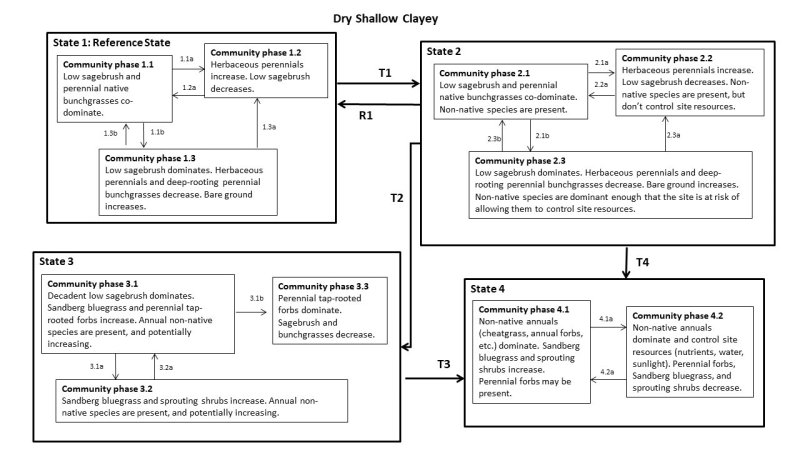
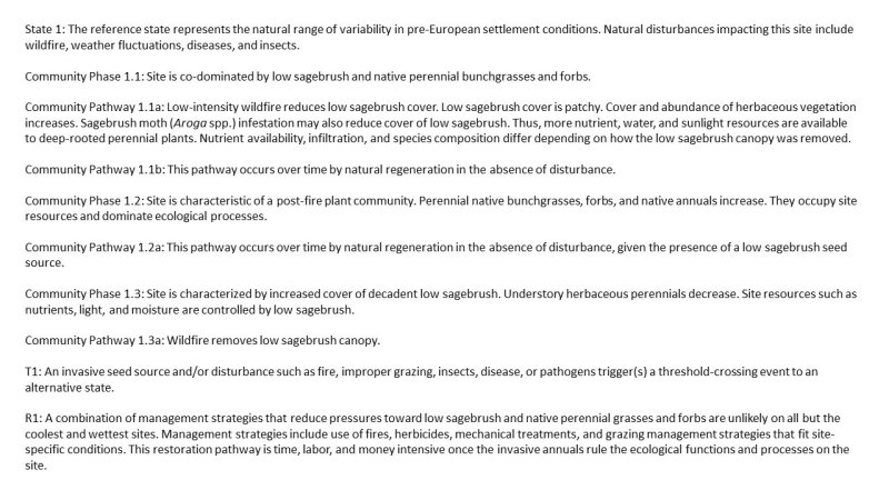
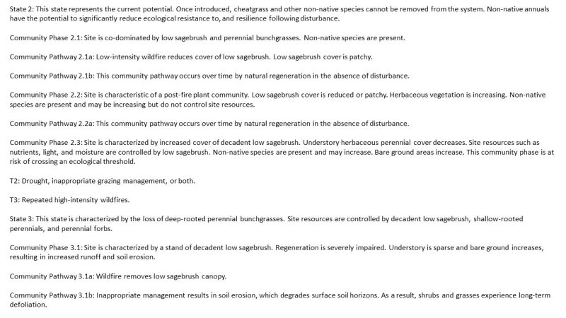
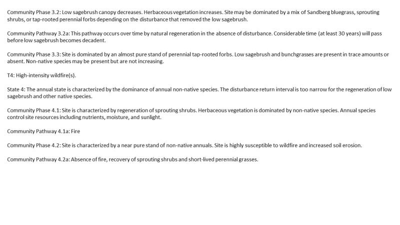
This habitat is generally dominated by broad-leaved evergreen shrubs 4 to 19 inches (0.1 to 0.5 meters) tall. Average shrub cover is typically 15 percent, but sometimes crowns touch (Cheatham and Haller 1975). There may be deciduous shrubs and small trees sparsely scattered in some areas. Ground cover of grasses and forbs is typically sparse, at 5 to 15 percent.
The habitat may be dominated by either low sagebrush or black sagebrush, often in association with yellow rabbitbrush, antelope bitterbrush, or big sagebrush. Black sagebrush is also commonly associated with winterfat and mormon tea. Western juniper may be sparsely scattered in stands dominated by low sagebrush. Utah juniper and singleleaf pinyon are sometimes scattered in stands dominated by black sagebrush. Common grass species include Sandberg bluegrass, bluebunch wheatgrass, squirreltail, Thurber’s needlegrass, and Idaho fescue. A rich variety of forbs is typically present. The abundance and distribution of associated plants are highly influenced by soils and precipitation.
This type commonly forms ecotones with sagebrush, pinyon-juniper, and juniper habitats in northeastern California. Thus, it may be difficult to determine the correct classification of some sites. For example, A. arbuscula communities are common as openings within coniferous forests on the Modoc Plateau. A. arbuscula communities may thus be found adjacent to mixed conifer, Jeffrey pine, or ponderosa pine stands. Climatic changes cause periodic shifts of ecotones, a relationship that is further complicated by invasion of coniferous woodlands into sagebrush habitats in response to fire suppression and grazing by domestic livestock.
Low sagebrush stands are "usually found on shallow soils with impaired drainage in the transition zone between the wetter bottom and open timber on the mountainsides". The type is also on terraces with hardpan or heavy clay soils. Where low sagebrush and antelope bitterbrush communities are mosaiced, low sagebrush grows on harsher sites (i.e., shallow, well-drained soils), antelope bitterbrush grows on areas with deeper soils. Black sagebrush stands typically grow on shallow, carbonate-rich, gravelly soils derived from limestone.
Information directly copied from:
California Wildlife Habitat Relationships System
California Department of Fish and Game
California Interagency Wildlife Task Group
By Jared Verner
Major Land Resource Area
MLRA 021X
Klamath and Shasta Valleys and Basins
Stage
Provisional
Click on box and path labels to scroll to the respective text.


