Ecological site group R021XG905CA
Dry Sandy
Last updated: 08/26/2024
Accessed: 02/08/2026
Ecological site group description
Key Characteristics
- Upland sites
- < 12" ppt
- > 20" depth
- Sandy texture
Provisional. A provisional ecological site description has undergone quality control and quality assurance review. It contains a working state and transition model and enough information to identify the ecological site.
Physiography
This ESG is predominantly on lake terraces, stream terraces, fan remnants, terraces, and alluvial plains with slopes of 0 to 2 percent.
Climate
The average annual precipitation in this MLRA is typically 9 to 25 inches (241 to 635 millimeters). It is highest, up to 57 inches (1,450 millimeters), in small areas at high elevations on the western and southwestern edges of this MLRA. Other high precipitation zones are in the scattered mountain ranges throughout the rest of this area. Most of the rainfall occurs as low- or moderate-intensity Pacific frontal storms during the winter. At the higher elevations, rain generally turns to snow. Snow may fall at the lower elevations in winter but does not last. Summers are dry. The average annual temperature is 37 to 53 degrees F (3 to 12 degrees C). The frost-free period is 70 to 185 days and averages 130 days.
Soil features
Typical soils for this concept range from loamy fine sands to loamy sands and can be divided into two categories: moderately deep, somewhat poorly drained soils formed in sediments weathered from tuff, basalt, diatomite, and ash; and very deep, somewhat excessively drained to excessively drained soils formed in alluvium or lacustrine deposits derived either from volcanic rocks with an influence of volcanic ash, or from extrusive igneous rock.
Representative soils include the Fordney (mixed, mesic Torripsammentic Haploxerolls), Poman (sandy, mixed, mesic Xeric Haplodurids), and Poe (sandy, mixed, mesic Typic Durixerepts) series.
Vegetation dynamics
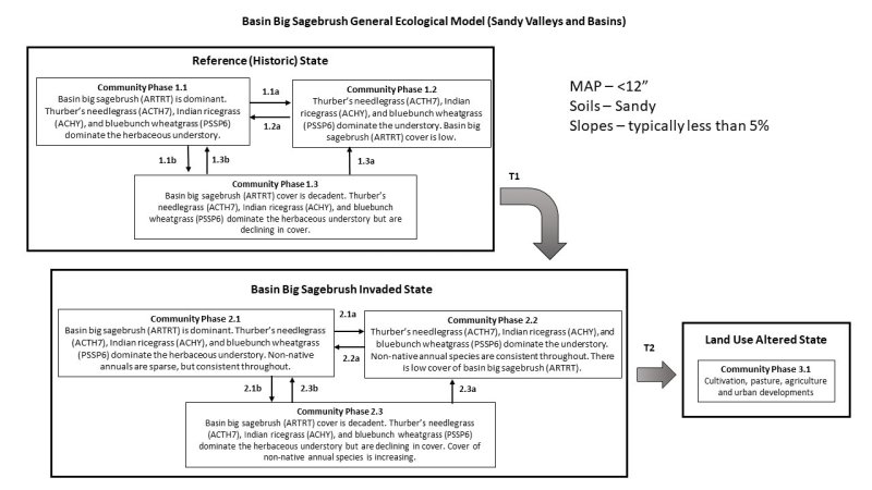
Basin big sagebrush grows on relatively more mesic habitats than other subspecies of big sagebrush. It commonly grows on plains, valley bottoms, lower foothill areas, or areas adjacent to drainages. Basin big sagebrush is associated with deep, seasonally dry, well drained soils. It commonly grows on sites with high water tables or deep moisture accumulations. Basin big sagebrush also grows on stratified sandy loam soils on floodplains or on low stream terraces [53]. In southeastern Idaho, basin big sagebrush is most abundant on sandy soils or on soils with relatively high sand content.
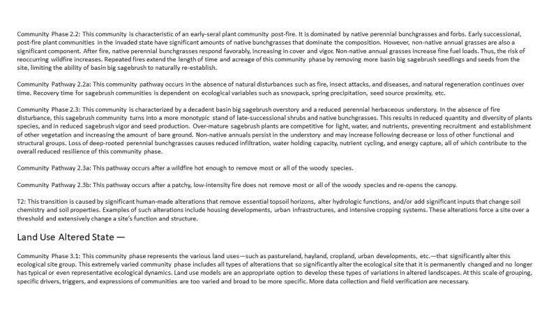
Basin big sagebrush is an indicator of productive sites because it tends to grow on deep, fertile soils. Many sites historically dominated by basin big sagebrush are now farmland. On farmlands basin big sagebrush is now restricted primarily to field edges, swales, and along drainageways.
Big sagebrush is the climax species on most of its present-day range. Research suggests that invasion into other vegetation types was uncommon. Humphrey describes big sagebrush as a "late successional" species in southeastern Idaho. Basin big sagebrush may increase on disturbed pastures that have been seeded to grasses such as crested wheatgrass (Agropyron cristatum).
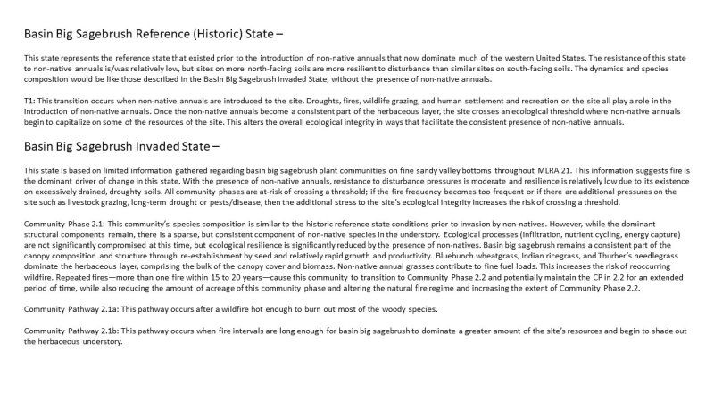
In many instances, basin big sagebrush shows only a moderate increase in density on disturbed sites but may exhibit large increases in crown density. Seedling establishment may begin immediately following a disturbance, but it usually takes a decade or more before big sagebrush dominates the site. Many basin big sagebrush sites are now depleted of "normal" perennial grasses and instead are now dominated by cheatgrass (Bromus tectorum).
Big sagebrush is killed by most fires. Prolific seed production from nearby unburned plants coupled with high germination rates enables seedlings to establish rapidly following fire. Wind-, water-, and animal-carried seed contribute to regeneration on a site. Few if any fire history studies have been conducted on basin big sagebrush. Research suggests that fire return intervals in basin big sagebrush are intermediate between mountain big sagebrush (5 to 15 years) and Wyoming big sagebrush (10 to 70 years). Note that "given the wide range of fuel situations and our understanding of yearly climatic variation in the sagebrush ecosystem, a naturally wide variation in fire frequency in this system should be expected".
In many basin big sagebrush communities, changes in fire patterns have occurred due to fire suppression and livestock grazing. Before the introduction of annuals, insufficient fuels may have limited fire spread in big sagebrush communities. Introduction of annuals has increased fuel loads so that fire can easily carry. Burning in some big sagebrush communities can set the stage for repeated fires. Fire frequency can be as little as five years, which is not sufficient time for the establishment and reproduction of big sagebrush. Repeated fires have removed big sagebrush from extensive areas in the Great Basin and Columbia River drainages.
Fire severity in big sagebrush communities is "variable" depending on weather, fuels, and topography. However, fire in basin big sagebrush communities is typically stand replacing.
Major Land Resource Area
MLRA 021X
Klamath and Shasta Valleys and Basins
Stage
Provisional
Click on box and path labels to scroll to the respective text.


