Ecological site group R021XG915CA
Wet Meadow
Last updated: 08/26/2024
Accessed: 02/08/2026
Ecological site group description
Key Characteristics
- Run-in site
Provisional. A provisional ecological site description has undergone quality control and quality assurance review. It contains a working state and transition model and enough information to identify the ecological site.
Physiography
This ESG is on run on landform positions such as valley bottoms, relict lakebeds, depressions, and flats. Slopes are 0 to 2 percent. Elevations are 3,000 to 5,000 feet (900 to 1,500 meters).
Climate
The average annual precipitation in this MLRA is typically 9 to 25 inches (241 to 635 millimeters). It is highest, up to 57 inches (1,450 millimeters), in small areas at high elevations on the western and southwestern edges of this MLRA. Other high precipitation zones are in the scattered mountain ranges throughout the rest of this area. Most of the rainfall occurs as low- or moderate-intensity Pacific frontal storms during the winter. At the higher elevations, rain generally turns to snow. Snow may fall at the lower elevations in winter but does not last. Summers are dry. The average annual temperature is 37 to 53 degrees F (3 to 12 degrees C). The frost-free period is 70 to 185 days and averages 130 days.
Soil features
The soils in this ESG consist of very deep, very poorly drained soils that formed in stratified alluvium from ash and lacustrine deposits, or mixed alluvium. They have peat or mucky surface horizons and show evidence of a water table, gleying, and mottling. The soils are primarily fine-textured.
Representative soils include the Pastolla (fine-silty, mixed, superactive, mesic Cumulic Endoaquolls), Tulebasin (fine, mixed, superactive, mesic Aquandic Endoaquolls), and Mountmed series (fine, smectitic, frigid Fluvaquentic Vertic Andeoaquolls).
Vegetation dynamics
Wet Meadows at all elevations generally have a simple structure that consists of a layer of herbaceous plants. Shrub or tree layers are usually absent or very sparse; they may, however, be an important feature of the meadow edge. Within the herbaceous plant community, a microstructure is typically present. Some species reach heights of only a few centimeters while other may grow 3 feet (1 meter) or taller. Except where broken by boulders, canopy cover is dense (60 to 100 percent). At the substrate surface, distances between individual shoots may be as small at 1 to 2 millimeters (0.04 to 0.08 inches) or as much as 2 to 3 centimeters (0.8 to 1.2 inches) depending upon the species present.
Wet Meadows consist of a great variety of plant species; therefore, it is not possible to generalize species composition. Species may differ, but several genera are common to Wet Meadows throughout the State. The include, Agrostis, Carex, Danthonia, Juncus, Salix, and Scirpus. Important grass and grass-like species include thingrass, abruptbeak sedge, beaked sedge, Nebraska sedge, tufted hairgrass, needle spikerush, fewflowered spikerush, common spikerush, Baltic rush, Nevada rush, irisleaf rush, pullup muhly, and panicled bulrush. Important forbs include tundra aster, Sierra shootingstar, trailing St. Johnswort, hairy waterclover, primrose monkeyflower, western cowbane, American bistort, cows clover, and small white violet. Willow and bilberry are the only shrubs found in abundance. Fewer species survive as surface water depth increases during spring runoff.
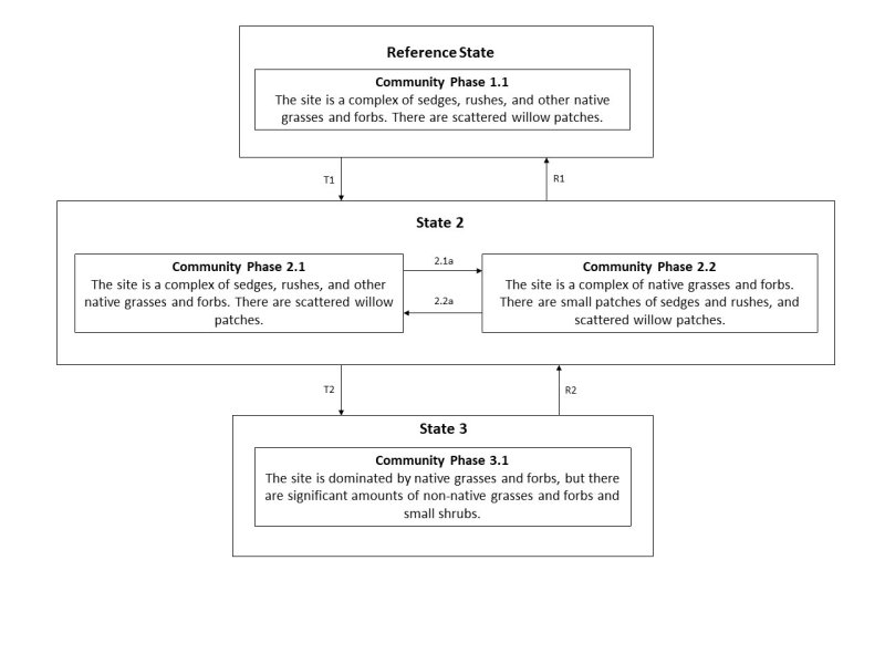
Differences in species composition between observations of Wet Meadow communities may therefore represent temporal fluctuations rather than successional trends. Perturbations that alter the Wet Meadow environment are usually necessary to set successional changes in motion. Overgrazed Wet Meadows have more forbs and fewer grasses and grass-like species that properly grazed or ungrazed (by livestock) meadows, and taller species are replaced by lower growing types. Channel erosion lowers the water table, causing successional to species of drier habitats.
The single most important characteristic of a Wet Meadow is its hydrology. Seasonality and reliability of yearly water inflows and outflows largely determine the vegetational stability of Wet Meadows. Therefore, Wet Meadow habitats exist indefinitely unless the hydrologic regimes are altered.
Wet Meadows establish where water is at or near the surface most of the growing season following spring runoff. Hydrologically, they establish on lotic, sunken concave, and hanging sites. Lotic sites are those with main input flow (other than precipitation) from upstream sources. At least early in the growing season, water flows across lotic sites at depths of 10 to 20 centimeters (4 to 8 inches). Downstream runoff is the principal output flow. Lotic sites are topographic basins that have slight slopes, which permits drainage of surface water. Percolation is negligible due to the saturated or slowly permeable nature of underlying materials. Sunken concave sites also receive water input from upstream sources, but evapotranspiration is the main output flow. Percolation is slowed by fine fuels, shallow bedrock, or both. However, in contrast to lotic and hanging sites, soil of sunken concave sites may dry to considerable depth by fall. Hanging sites are watered by hydrostatic flows as springs or seeps. They are typically on rather steep slopes, and downstream runoff is the main output flow. Surface flows, although constant, are usually no more than 1 centimeter (0.4 inches) deep.
Directly copied from the CWHR Database, describing Wet Meadows:
California Wildlife Habitat Relationships System
California Department of Fish and Game
California Interagency Wildlife Task Group
Raymond D. Ratliff
Major Land Resource Area
MLRA 021X
Klamath and Shasta Valleys and Basins
Stage
Provisional
Click on box and path labels to scroll to the respective text.

