Ecological site group F022AW008CAESG
Shallow Frigid Mountains <40"ppt
Last updated: 08/02/2023
Accessed: 02/21/2026
Ecological site group description
Key Characteristics
- mountains
- frigid temp regime
- <40" ppt
- <20" depth
Provisional. A provisional ecological site description has undergone quality control and quality assurance review. It contains a working state and transition model and enough information to identify the ecological site.
Physiography
This ESG is found on mountainous uplands generally above 5000 ft. on variable slopes.
Climate
Annual precipitation at these sites is less than 40 inches (1000 millimeters). The amount of precipitation increases with elevation and from south to north. Summers are dry, but there are occasional thunderstorms. Much of the winter precipitation occurs as snow. The average annual temperature is 25 to 63 degrees F (-4 to 17 degrees C), decreasing with elevation. The freeze-free period averages 205 days and ranges from 65 to 345 days, decreasing in length with elevation. It is longest at the lower elevations along the western edge of the area.
Soil features
The soils most dominant in this ESG are shallow, well drained to excessively drained soils that formed in colluvium and residuum from granitic or volcanic rocks.
Aldi, a clayey, smectitic, frigid Lithic Ultic Argixerolls
Toem, a mixed, frigid, shallow Dystric Xeropsamments
Vegetation dynamics
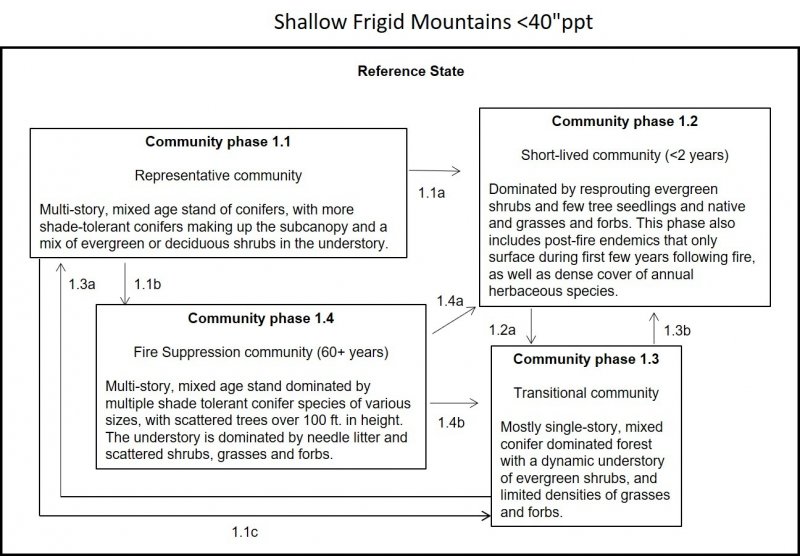
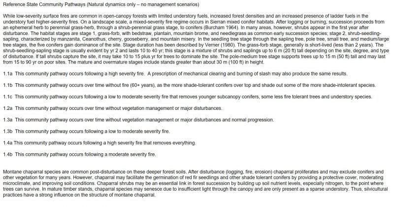
This ESG is characterized by shallow, frigid soils on mountain landforms with less than 40 inches of precipitation resulting in water stress during the warmest parts of the year. It is part of the Sierran mixed conifer habitat type and is an assemblage of conifer and hardwood species that forms a multilayered forest. Historically, burning and logging have caused wide variability in stand structure, resulting in both even-aged and uneven-aged stands. Virgin old-growth stands where fire has been excluded are often two-storied, with the overstory comprised of mixed conifer and the understory white fir and incense-cedar. Forested stands form closed, multilayered canopies with nearly 100 percent overlapping cover. When openings occur, shrubs are common in the understory. Closed canopy stand distribution is both extensive and patchy depending on scale, site, slope, soils, microclimate, and history.
At maturity, the dominant conifers range from 30 to 60 m (100 to 200 ft) tall with a highly variable basal area of about 17 to 26 sq m (180 - 280 sq ft). Diameter breast height at maturity for pines and Douglas-fir is commonly greater than 1 m (40 in); white fir greater than 0.9 m (35 in) is common. Fuel loading in stands heavy with pine may reach 27,000 kg/ha (70 to 80 t/ac) in natural stands; whereas fuel loading in stands heavy with fir may reach 16,000 kg/ha (40 to 50 t/ac).
Five conifers and one hardwood typify the mixed conifer forest white fir, Douglas-fir, ponderosa pine, sugar pine, incense-cedar, and California black oak. White fir tends to be the most ubiquitous species (though most often a minor overstory component) because it tolerates shade and has the ability to survive long periods of suppression in brush fields Douglas-fir dominates the species mix in the north but is absent south of the Merced River. Ponderosa pine dominates at lower elevations and on south slopes. Jeffrey pine commonly replaces ponderosa pine at high elevations, on cold sites, or on ultramafic soils. Red fir is a minor associate at the highest elevations. Sugar pine is found throughout the mixed conifer type. Black oak is a minor, but widespread, component in mixed conifer stands. Though black oak does best on open sites, it is maintained under adverse conditions such as shade, ridge tops, and south slopes where conifers may regenerate in its shade. This ESG is primarily dominated by Jeffery pine, ponderosa, white fir, Douglas-fir, incense-cedar, sugar pine, snowbrush, greenleaf manzanita, Sierra chinkapin, western serviceberry, snowbrush ceanothus, and pinemat manzanita.
California Wildlife Habitat Relationships System
California Department of Fish and Game
California Interagency Wildlife Task Group
Barbara H. Allen (2005)
Major Land Resource Area
MLRA 022A
Sierra Nevada and Tehachapi Mountains
Subclasses
- F022AF003CA–Frigid, Loamy, Fragipan, Outwash
- F022AF004CA–Frigid, Shallow To Deep, Sandy Mountain Slopes
- F022AW008CA–Shallow Frigid Mountains <40"ppt
- F022AY102NV–PICO/ARTRV/CAREX
- F022AY116NV–PIJE/ARTRV/ACOCO
- F022AY118NV–ABMA-PICO/ARTRV/BRMA4
- F022AY129NV–PIJE/ARPA6-PUTR2
- F022AY130NV–Pinus Jeffreyi/ Artemisia Tridentata Ssp. Vaseyana-Purshia
- R022AD002CA–Gravely Bedrock Slopes
- R022AD009CA–Bedrock Pocket Valley Bottoms
- R022AY011NV–MOUNTAIN RIDGE 30+ P.Z.
- R022AY024NV–MAHOGANY SAVANNA
- R022AY025NV–MAHOGANY THICKET
- R022AY028NV–CLAYPAN 16+ P.Z.
- R022AZ041CA–ERODED SLOPE 14-20 P.Z.
- R022AZ042CA–SHALLOW LOAM 16-20 P.Z.
Correlated Map Unit Components
22824241, 22822964, 22823264, 22945118, 22945344, 22667568, 22667289, 22667666, 22667664, 22667460, 22667570, 22667577, 22667579, 22667573, 22667713, 22667855, 22667857, 22667346, 22667344, 22667726, 22667358, 22668089, 22667956, 22667562, 22667052, 22667322, 22667326, 22667320, 22667321, 22667311, 22667310, 22667120, 23016477, 23016241, 23015857, 23016409, 23016126, 23020674, 23025606, 23025223, 23026887, 23026891, 23027386, 23026957, 23026956, 23026960, 23026962, 23027192, 23027193, 23027449, 23027195, 23027454, 23027648, 23027651, 23027655, 23027660, 23027459, 23027201, 23027204, 23027206, 23026965, 23026966, 23026968, 23026971, 23026977, 23027210, 23027668, 23027670, 23027675, 23027225, 23027486, 23027229, 23027720, 23027721, 23027724, 23027728, 23027272, 23027271, 23027529, 23027527, 23027045, 23027287, 23027539, 23027291, 23027545, 23027297, 23027049, 23027059, 23027064, 23027301, 23027547, 23027549, 23027311, 23027312, 23027558, 23027315, 23027318, 23027068, 23027072, 23027077, 23027081, 23027085, 23027565, 23027333, 23027941, 23027851, 23027784, 23028023, 23028025, 23027586, 23027128, 23027369, 23028342, 23028532, 23028180, 23028535, 23028562, 23028208, 23028587, 23028397, 23028401, 23028234, 23028124, 23028299, 23028301, 23488028, 23488205, 23488409, 23488211, 23488052, 23488060, 23488486, 23488230, 23488499, 23488248, 23488265, 23488266, 23488299, 23488291, 23488297, 23488290, 23488308, 23488302, 23488324, 23488335, 23488339, 23488515, 23489003, 23488353, 23488357, 23488354, 23488350, 23488372, 23488380, 23488384, 23488390, 23488394, 23488534, 23488543, 23488776, 23488569, 23488196, 23488604, 23488637, 23488673, 23488670, 23488694, 23488689, 23488795, 23488792, 23488902, 23488928, 23488950, 23488966, 23489054, 23488807, 23489078, 23489095, 23488699, 22591413, 22591416, 22591425, 22591427, 22591799, 22591750, 22592018, 22591518, 23483148, 23483975, 23483985, 23483909, 23483907, 23483391, 23483479, 23483485, 23483534, 23483535, 23483542, 23483557, 22595687, 22595691, 22595514, 22595522, 22595533, 22595314, 22595358, 22595625, 22596037, 22596052, 22610144, 22609855, 22610027, 23030887, 23030596, 23030882, 23030196, 23030188, 23030180, 23030172, 23030844, 23030547, 23030163, 23030158, 23029322, 23029404, 23031596, 23032297, 23032115, 23032481, 23032474, 23149978, 23149985, 23149700, 23149125, 23150892, 23151060, 23150966, 23150977, 23150979, 23150870, 23150874, 23150909, 23151069, 23151158, 23256904, 23256853, 23256861, 23256173, 23256177, 23256867, 23256248, 23256250
Stage
Provisional
Contributors
Curtis Talbot
Click on box and path labels to scroll to the respective text.

