
Natural Resources
Conservation Service
Ecological site R002XN603WA
Bog or Fen
Last updated: 12/09/2024
Accessed: 02/08/2026
General information
Provisional. A provisional ecological site description has undergone quality control and quality assurance review. It contains a working state and transition model and enough information to identify the ecological site.
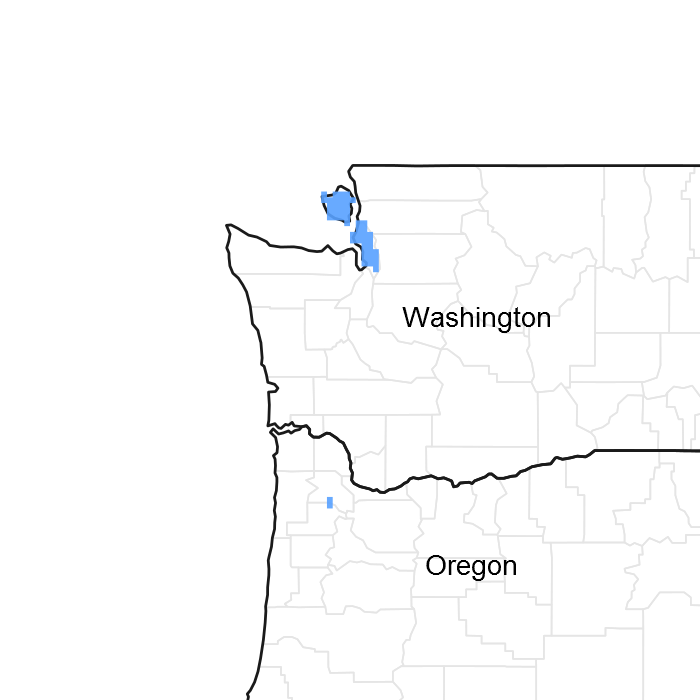
Figure 1. Mapped extent
Areas shown in blue indicate the maximum mapped extent of this ecological site. Other ecological sites likely occur within the highlighted areas. It is also possible for this ecological site to occur outside of highlighted areas if detailed soil survey has not been completed or recently updated.
MLRA notes
Major Land Resource Area (MLRA): 002X–Willamette and Puget Sound Valleys
Major Land Resource Area-[MLRA][LRU]: 002X N Willamette and Puget Sound Valleys, North Puget. The Land Resource Unit (LRU) is described in detail in the reference Washington NRCS Pasture TN-101 Forage Zones available on the eFOTG. For more information on MLRA’s, refer to the following web site: http://www.essc.psu.edu/soil_info/soil_lrr/. Additional information on Common Resource Areas is available on the eFOTG for NRCS Washington: http://efotg.nrcs.usda.gov/efotg_locator.aspx?map=WA and the following website: http://soils.usda.gov/survey/geography/cra.html. This ecological site occurs in the following Common Resource Areas: 2.10 - Fraser Lowland; 2.11 - Eastern Puget Riverine Lowlands; 2.11 - Eastern Puget Mountain River Valleys; 2.12 - San Juan Islands; 2.13 - Olympic Rainshadow; 2.5 - Eastern Puget Uplands; and 2.6 - Central Puget Lowland
Table 1. Dominant plant species
| Tree |
(1) Pinus contorta |
|---|---|
| Shrub |
(1) Ledum groenlandicum |
| Herbaceous |
(1) Carex |
Physiographic features
These plant communities typically occur in depressional areas with accumulations of undecomposed or partially decomposed organic matter and high water tables.
Table 2. Representative physiographic features
| Landforms |
(1)
Depression
|
|---|---|
| Flooding frequency | None |
| Ponding duration | Very long (more than 30 days) |
| Ponding frequency | None to frequent |
| Elevation | 20 – 500 ft |
| Slope | 2% |
| Ponding depth | 4 – 16 in |
| Water table depth | 12 – 26 in |
| Aspect | Aspect is not a significant factor |
Climatic features
The average annual precipitation ranges from 18 to 60 inches, although most areas range from 30 to 50 inches. Annual precipitation less than 30 inches occurs in the rainshadow of the Olympic Mountains along the western border of this area and in the San Juan Islands. Higher average annual precipitation, 50 to 60 inches, occurs next to the foothills of the surrounding mountains. Most of the precipitation occurs as low intensity, Pacific frontal storms. The distribution is 75% in the fall and winter, 15% in the spring and 10% in the summer. Rain turns to snow at the higher elevations, although accumulations are usually small and of short duration. The number of days with snow on the ground varies from 0 to 9, with an averge of 3 days. Summers are cool and dry. Recorded temperature extremes range from -1 degrees to 90 degrees fahrenheit. See the climate tables in this document for information on temperatures and frost-free periods.
Table 3. Representative climatic features
| Frost-free period (average) | 243 days |
|---|---|
| Freeze-free period (average) | 302 days |
| Precipitation total (average) | 60 in |
Figure 2. Monthly precipitation range
Figure 3. Monthly average minimum and maximum temperature
Influencing water features
These general kinds of bog and fen wetlands are distinguished by pH, nutrient availability and hydrologic dynamics. Fens have groundwater within the rooting zone of vascular plants, while bogs have built up peat above the influence of groundwater. The vegetation in true bogs are limited by the water available from precipitation and are only found in areas of high precipitation.
Soil features
The soils generally have a water table at or near the soil surface for much of the winter and spring, and the water table is often at or within a few feet of the soil surface for the remainder of the year. These soils are typically nutrient-poor and have an acidic pH. A soil series on which this site occurs is Semiahmoo.
Table 4. Representative soil features
| Surface texture |
(1) Muck |
|---|---|
| Family particle size |
(1) Loamy |
| Drainage class | Very poorly drained |
| Permeability class | Moderate to moderately slow |
| Surface fragment cover <=3" | Not specified |
| Surface fragment cover >3" | Not specified |
| Available water capacity (0-40in) |
9.6 – 23.5 in |
| Soil reaction (1:1 water) (0-40in) |
4 – 6 |
| Subsurface fragment volume <=3" (Depth not specified) |
Not specified |
| Subsurface fragment volume >3" (Depth not specified) |
Not specified |
Ecological dynamics
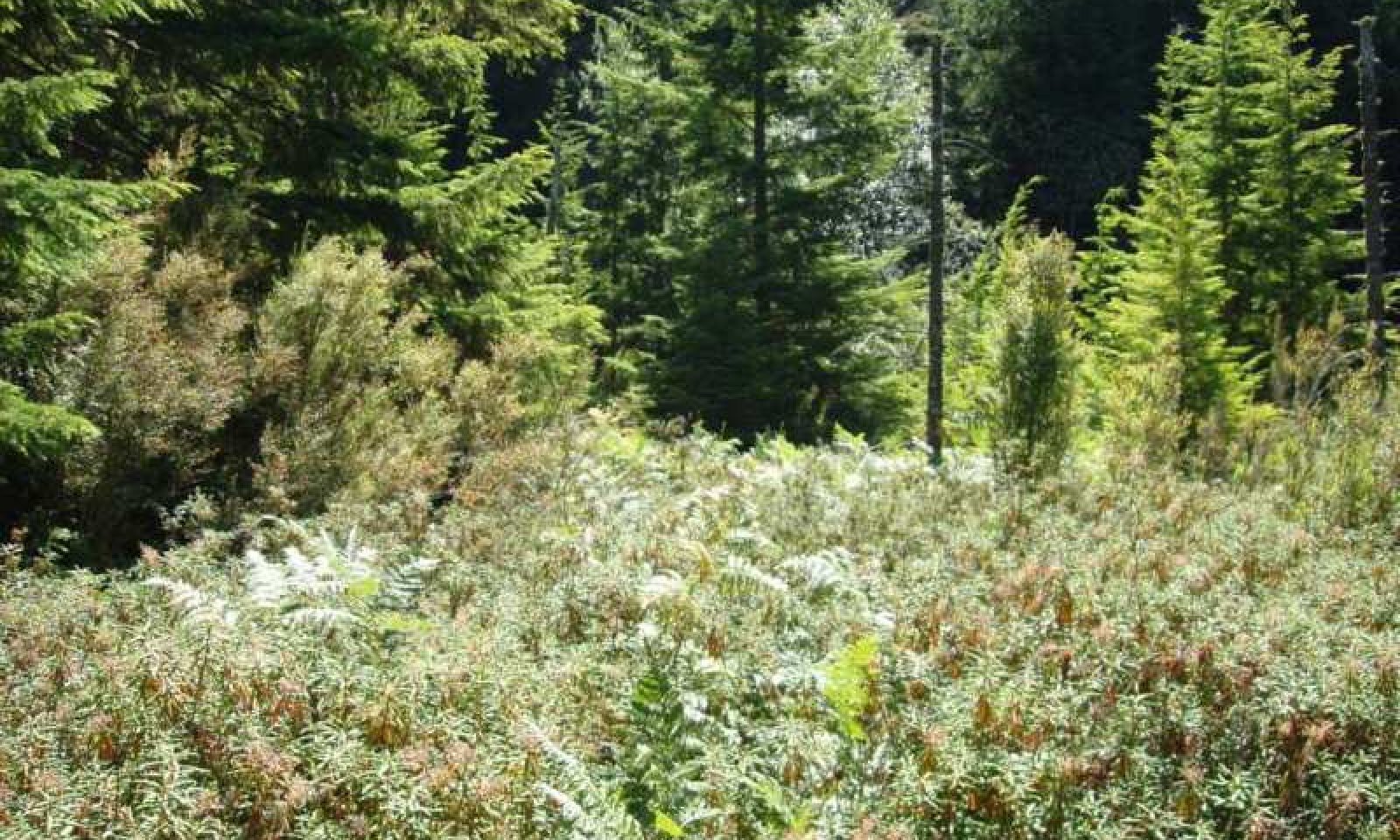
These areas may have historically been kept free of extensive brush and tree cover by burning. Typical native plant species include Labrador tea (Ledum groenlandicum), salal (Gaultheria shalon), spirea (Spiraea douglasii), sedges (Carex spp.), and minor amounts of shore pine (Pinus contorta).
State and transition model
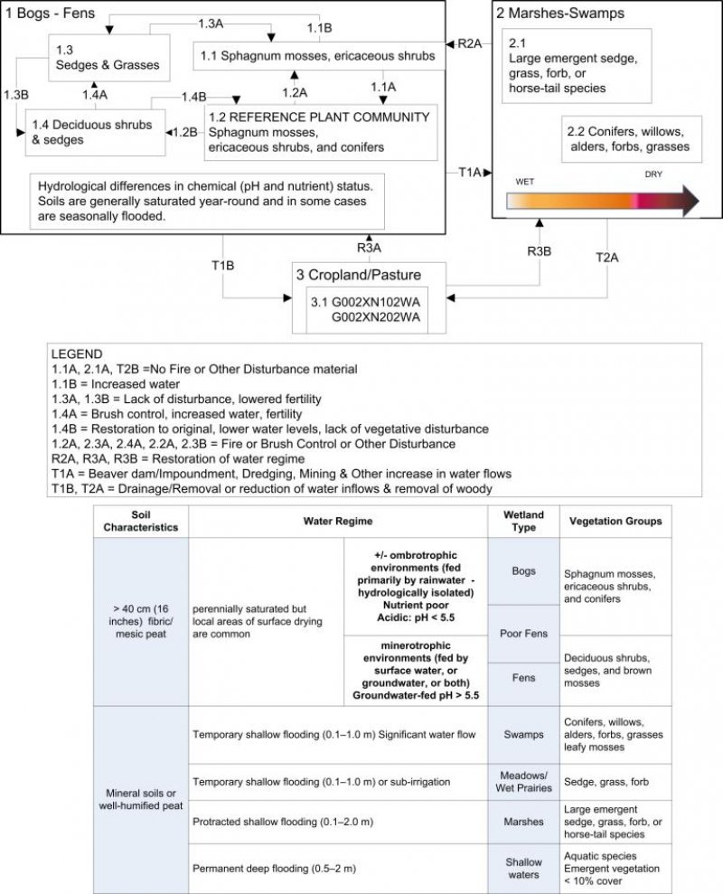
More interactive model formats are also available.
View Interactive Models
More interactive model formats are also available.
View Interactive Models
Click on state and transition labels to scroll to the respective text
Ecosystem states
State 2 submodel, plant communities
State 3 submodel, plant communities
State 1
Reference
These wetland plant communites occur in peatlands. These wetlands are usually occur as patch communites in river valleys, in depressions, around lakes and marshes, or on slopes. Near salt water these organic soils are characterized by an abundance of sodium cations from oceanic precipitation. Poor fens and bogs are the most common type and are often intermixed. Sphagnum characterizes poor fens and bogs (pH <5.5), and the two are lumped here, while "brown mosses" and sedges characterize rich fens (pH >5.5). Mire profiles in may be flat, raised (domed), or sloping, but most occurrences in Washington are flat with only localized hummock development.
Community 1.1
Sphagnum Moss Mounds and Ericaceous Shrubs
The surface topography in this community consists of well developed hummocks and hollows that create a diverse array of drier hummock tops to wetter hollows. Kalmia microphylla, Ledum groenlandicum, and Vaccinium oxycoccos are often codominant.
Figure 4. Annual production by plant type (representative values) or group (midpoint values)
Figure 5. Plant community growth curve (percent production by month). WA0225, Winter Water Table. Winter water table within ~12" of soil surface for significant period between Nov 1 - April 1.
| Jan | Feb | Mar | Apr | May | Jun | Jul | Aug | Sep | Oct | Nov | Dec |
|---|---|---|---|---|---|---|---|---|---|---|---|
| J | F | M | A | M | J | J | A | S | O | N | D |
| 0 | 0 | 2 | 8 | 22 | 20 | 18 | 16 | 11 | 3 | 0 | 0 |
Community 1.2
Sphagnum Mosses, Ericaceous Shrubs, and Conifers

Figure 6. Reference Plant Community
These plant communities occur adjacent to open fens, peatlands and shrub-swamps. The tree layer is dominated by Pinus contorta. Tsuga heterophylla and/orThuja plicata may be abundant in drier sites but is suppressed or killed in waterlogged soils. Pinus contorta is also killed by extended flooding. The dense shrub layer is comprised of Gaultheria shallon and Ledum glandulosum, Vaccinium oxycoccos, Kalmia microphylla, and Empetrum nigrum. Most trees and shrubs occur on elevated microsites such as decaying logs, stumps, and old root wads. The herb layer is dominated by Carex obnupta, Blechnum spicant, Pteridium aqulinum and Sanguisorba officinalis. Sphagnum mosses are conspicuous. Stands are usually stunted in stature but are subject to windthrow in severe winter storms but appear to be self-perpetuating in the absence of major disturbance.
Figure 7. Annual production by plant type (representative values) or group (midpoint values)
Table 5. Annual production by plant type
| Plant type | Low (lb/acre) |
Representative value (lb/acre) |
High (lb/acre) |
|---|---|---|---|
| Forb | 300 | 400 | 500 |
| Shrub/Vine | 200 | 300 | 400 |
| Grass/Grasslike | 100 | 200 | 300 |
| Total | 600 | 900 | 1200 |
Figure 8. Plant community growth curve (percent production by month). WA0225, Winter Water Table. Winter water table within ~12" of soil surface for significant period between Nov 1 - April 1.
| Jan | Feb | Mar | Apr | May | Jun | Jul | Aug | Sep | Oct | Nov | Dec |
|---|---|---|---|---|---|---|---|---|---|---|---|
| J | F | M | A | M | J | J | A | S | O | N | D |
| 0 | 0 | 2 | 8 | 22 | 20 | 18 | 16 | 11 | 3 | 0 | 0 |
Community 1.3
Sedges and Grasses
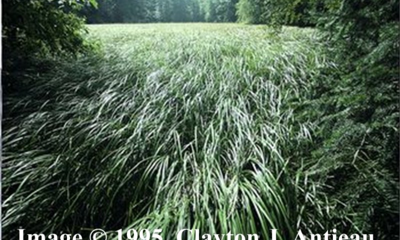
Wetlands or the portion of wetlands dominated by emergent (mostly graminoid) species where standing water is seasonally or more typically semi-permanently present. Confined to limited areas in suitable floodplain or basin topography. Often found along the borders of ponds, lakes or reservoirs that have more open basins and a permanent water source throughout all or most of the year. Mostly semi-permanently flooded, but some marshes have seasonal hydrologic flooding. Water is at or above the surface for most of the growing season. Dominated by emergent herbaceous species, mostly grass-likes (Carex and grasses) but also some forbs. Grasses will be more abundant on the drier portions of the wetland.
Community 1.4
Deciduous Shrubs and Sedges
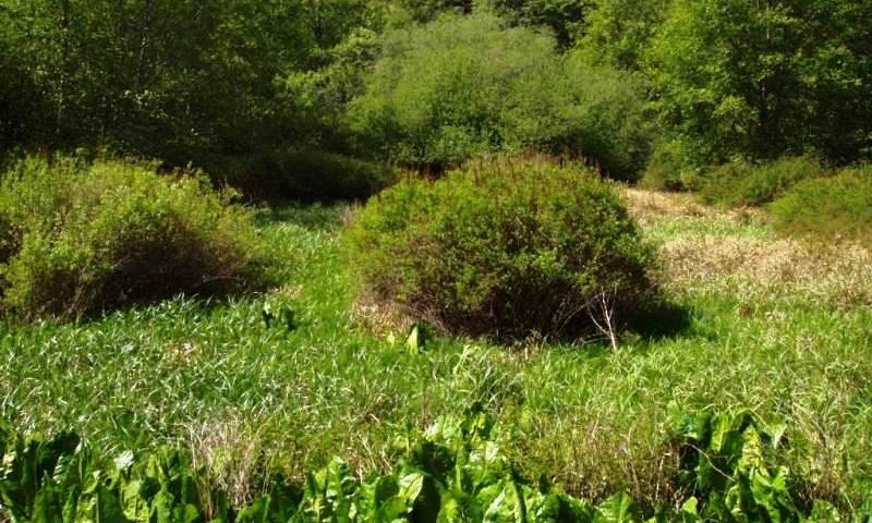
Figure 9. Fen with spirea, carex and skunk cabbage
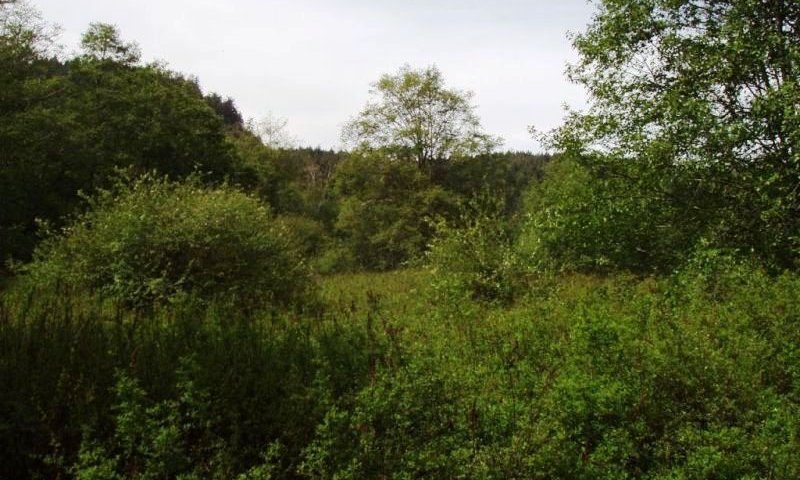
Figure 10. Fen with dense spirea
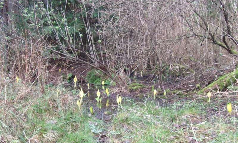
Figure 11. Deciduous shrub fen with carex and skunk cabbage
Pathway 1.1A
Community 1.1 to 1.2
Lack of fire or other disturbances allows cover of shrubs and trees to increase.
Pathway 1.1B
Community 1.1 to 1.3
Change in water regime to one with more inflow and outflow from the site, or increased water depth. Causes may include beaver dam impoundment, dredging, mining activity, or changes in local surface hydrology.
Pathway 1.2A
Community 1.2 to 1.1
Fire, woody harvest, or other disturbance that removes conifers.
Pathway 1.2B
Community 1.2 to 1.4


Change in water regime to one with more inflow and outflow from the site, or increased water depth. Causes may include beaver dam impoundment, dredging, mining activity, or changes in local surface hydrology.
Pathway 1.3A
Community 1.3 to 1.1
Restoration of lower water levels and reduction in water moving into and out of the site. Also, reduction of disturbance, either by fire or mechanical means. Reduction of fertility through reduction in water flows or added fertilizer.
Pathway 1.3B
Community 1.3 to 1.4


Limited restoration of lower water levels and reduction in water moving into and out of the site. Also, limited reduction of disturbance, which allows the shrub layer to reestablish. Limited reduction of fertility through reduction in water flows or added fertilizer.
Pathway 1.4B
Community 1.4 to 1.2


Restoration of lower water levels and reduction in water moving into and out of the site. Also, reduction of disturbance, either by fire or mechanical means. Reduction of fertility through reduction in water flows or added fertilizer.
Pathway 1.4A
Community 1.4 to 1.3


This shift may be caused by increases in disturbance, water levels, or site fertility. Change in water regime may include one with more inflow and outflow from the site, or increased water depth. Causes may include beaver dam impoundment, dredging, mining activity, or changes in local surface hydrology. Disturbance to vegetation may occur through fire or mechanical disturbance. Fertility may be increases through the chemical composition of the increased waterflow, or decomposition of vegetation.
State 2
Hydrologically Altered
The major agents of wetland disturbances have been beavers, floods, landslides, tsunamis, windthrow, fire, and people. People affect the water regime with impoundments, drainage systems and cropping, road building, dredging, mining and other changes. These wetland disturbance agents shape the development of different types of vegetation by mediating the supply, movement, and chemistry of water and sediments.
Community 2.1
Large Emergent Sedge, Grass, Forb, or Horsetail Species
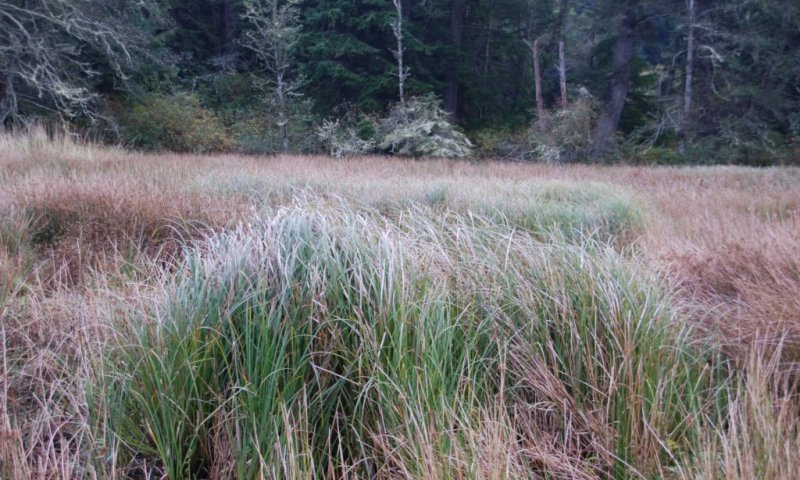
Wetlands or the portion of wetlands dominated by emergent (mostly graminoid) species where standing water is seasonally or more typically semi-permanently present. Depending on the water regime, these plant communities are dominated by emergent herbaceous species, mostly graminoids (Carex, Scirpus and/or Schoenoplectus, Eleocharis, Juncus, Typha latifolia) but also some forbs. The most serious invasive species of emergent marsh and wet prairie are Phalaris arundinacea (reed canarygrass), Agrostis stolonifera (redtop or creeping bentgrass), Poa pratensis (Kentucky bluegrass), and Alopecurus pratensis (meadow foxtail).
Community 2.2
Conifers, Willows, Alders, Forbs, Grasses
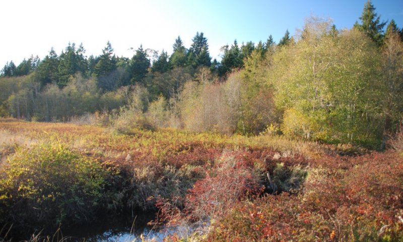
Shrub swamps and wetlands are dominated by shrubs.They occur on floodplains and basins, and most tolerate a variable water regime. Plant community structure ranges from scattered shrubs with intervening herbaceous component, to dense and impenetrable stands of Salix, Cornus sericea, and Spiraea douglasii. Depending on water regime and disturbances this plant community is seral to alder and conifer forests.
State 3
Drained Converted
These cropped systems are managed primarily with drainage systems and agronomically practices, including increased inputs of nutrients.
Community 3.1
G002XN102WA or G002XN202WA Forage Suitability Group
The forage suitability group is determined by the effectiveness of drainage and removal of water inflows.
Transition T1A
State 1 to 2
Change in water regime to one with more inflow and outflow from the site, or increased water depth. Causes may include beaver dam impoundment, dredging, mining activity, or changes in local surface hydrology.
Transition T1B
State 1 to 3
Drainage of site to lower the water table to the level necessary to grow the selected crop. Practices may include ditching, tile drainage, diversion of water inflows and/or removal of woody material.
Restoration pathway R2A
State 2 to 1
Restoration of water regime through management of depth control structures and/or management of water inflows and outflows.
Transition T2A
State 2 to 3
Drainage of site to lower the water table to the level necessary to grow the selected crop. Practices may include ditching, tile drainage, diversion of water inflows and/or removal of woody material.
Restoration pathway R3A
State 3 to 1
Restoration of water regime through depth control structures and/or management of water inflows and outflows.
Restoration pathway R3B
State 3 to 2
Restoration of water regime through depth control structures and/or management of water inflows and outflows.
Additional community tables
Table 6. Community 1.1 plant community composition
| Group | Common name | Symbol | Scientific name | Annual production (lb/acre) | Foliar cover (%) | |
|---|---|---|---|---|---|---|
|
Shrub/Vine
|
||||||
| 1 | Ericaceous Shrubs | 100–200 | ||||
| bog Labrador tea | LEGR | Ledum groenlandicum | 0 | 45–75 | ||
| alpine laurel | KAMI | Kalmia microphylla | 0 | 18–30 | ||
| black crowberry | EMNI | Empetrum nigrum | 0 | 12–20 | ||
| small cranberry | VAOX | Vaccinium oxycoccos | 0 | 8–12 | ||
| great burnet | SAOF3 | Sanguisorba officinalis | 0 | 2–4 | ||
| American skunkcabbage | LYAM3 | Lysichiton americanus | 0 | 2–4 | ||
|
Forb
|
||||||
| 2 | Forbs | 10–40 | ||||
| great burnet | SAOF3 | Sanguisorba officinalis | 0 | 2–4 | ||
| deer fern | BLSP | Blechnum spicant | 0 | 1–2 | ||
| American skunkcabbage | LYAM3 | Lysichiton americanus | 0 | 1–2 | ||
|
Grass/Grasslike
|
||||||
| 3 | Grasses and Grasslike | 100–200 | ||||
| sedge | CAREX | Carex | 0 | 8–16 | ||
Table 7. Community 1.2 plant community composition
| Group | Common name | Symbol | Scientific name | Annual production (lb/acre) | Foliar cover (%) | |
|---|---|---|---|---|---|---|
|
Shrub/Vine
|
||||||
| 1 | Ericaceous and other shrubs | 200–400 | ||||
| bog Labrador tea | LEGR | Ledum groenlandicum | 0 | 45–75 | ||
| alpine laurel | KAMI | Kalmia microphylla | 0 | 18–30 | ||
| black crowberry | EMNI | Empetrum nigrum | 0 | 10–14 | ||
| small cranberry | VAOX | Vaccinium oxycoccos | 0 | 8–12 | ||
| salal | GASH | Gaultheria shallon | 0 | 3–7 | ||
|
Forb
|
||||||
| 2 | Forbs | 300–500 | ||||
| western brackenfern | PTAQ | Pteridium aquilinum | 0 | 16–26 | ||
| great burnet | SAOF3 | Sanguisorba officinalis | 0 | 11–17 | ||
| deer fern | BLSP | Blechnum spicant | 0 | 8–16 | ||
| western cordilleran bunchberry | COUN | Cornus unalaschkensis | 0 | 1–3 | ||
| false lily of the valley | MADI | Maianthemum dilatatum | 0 | 1–3 | ||
|
Grass/Grasslike
|
||||||
| 3 | Grasses and Grasslike | 100–300 | ||||
| slough sedge | CAOB3 | Carex obnupta | 0 | 13–21 | ||
|
Tree
|
||||||
| 4 | Conifers | 0 | ||||
| lodgepole pine | PICO | Pinus contorta | 0 | 0–12 | ||
| western redcedar | THPL | Thuja plicata | 0 | 0–12 | ||
| western hemlock | TSHE | Tsuga heterophylla | 0 | 0–12 | ||
Interpretations
Supporting information
Contributors
Martha Chaney
Approval
Kirt Walstad, 12/09/2024
Rangeland health reference sheet
Interpreting Indicators of Rangeland Health is a qualitative assessment protocol used to determine ecosystem condition based on benchmark characteristics described in the Reference Sheet. A suite of 17 (or more) indicators are typically considered in an assessment. The ecological site(s) representative of an assessment location must be known prior to applying the protocol and must be verified based on soils and climate. Current plant community cannot be used to identify the ecological site.
| Author(s)/participant(s) | |
|---|---|
| Contact for lead author | |
| Date | 11/27/2024 |
| Approved by | Kirt Walstad |
| Approval date | |
| Composition (Indicators 10 and 12) based on | Annual Production |
Indicators
-
Number and extent of rills:
-
Presence of water flow patterns:
-
Number and height of erosional pedestals or terracettes:
-
Bare ground from Ecological Site Description or other studies (rock, litter, lichen, moss, plant canopy are not bare ground):
-
Number of gullies and erosion associated with gullies:
-
Extent of wind scoured, blowouts and/or depositional areas:
-
Amount of litter movement (describe size and distance expected to travel):
-
Soil surface (top few mm) resistance to erosion (stability values are averages - most sites will show a range of values):
-
Soil surface structure and SOM content (include type of structure and A-horizon color and thickness):
-
Effect of community phase composition (relative proportion of different functional groups) and spatial distribution on infiltration and runoff:
-
Presence and thickness of compaction layer (usually none; describe soil profile features which may be mistaken for compaction on this site):
-
Functional/Structural Groups (list in order of descending dominance by above-ground annual-production or live foliar cover using symbols: >>, >, = to indicate much greater than, greater than, and equal to):
Dominant:
Sub-dominant:
Other:
Additional:
-
Amount of plant mortality and decadence (include which functional groups are expected to show mortality or decadence):
-
Average percent litter cover (%) and depth ( in):
-
Expected annual annual-production (this is TOTAL above-ground annual-production, not just forage annual-production):
-
Potential invasive (including noxious) species (native and non-native). List species which BOTH characterize degraded states and have the potential to become a dominant or co-dominant species on the ecological site if their future establishment and growth is not actively controlled by management interventions. Species that become dominant for only one to several years (e.g., short-term response to drought or wildfire) are not invasive plants. Note that unlike other indicators, we are describing what is NOT expected in the reference state for the ecological site:
-
Perennial plant reproductive capability:
Print Options
Sections
Font
Other
The Ecosystem Dynamics Interpretive Tool is an information system framework developed by the USDA-ARS Jornada Experimental Range, USDA Natural Resources Conservation Service, and New Mexico State University.
Click on box and path labels to scroll to the respective text.