Natural Resources
Conservation Service
Ecological site F006XC003WA
Cool Frigid Moist Xeric Mountain Slopes (Grand fir Cool Moist Shrub/Herb)
Last updated: 4/01/2025
Accessed: 02/08/2026
General information
Provisional. A provisional ecological site description has undergone quality control and quality assurance review. It contains a working state and transition model and enough information to identify the ecological site.
MLRA notes
Major Land Resource Area (MLRA): 006X–Cascade Mountains, Eastern Slope
Major Land Resource Area (MLRA): 006X–Cascade Mountains, Eastern Slope.
Stretching from northern Washington to southern Oregon, MLRA 6 encompasses the mountain slopes, foothills, elevated plateaus and valleys on the eastern slopes of the Cascade mountains. This MLRA is a transitional area between the Cascade Mountains to the west and the lower lying Columbia Basalt Plateau to the east. Situated in the rain shadow of the Cascade Crest, this MLRA receives less precipitation than portions of the cascades further west and greater precipitation than the basalt plateaus to the east. Geologically, the majority of the MLRA is dominated by Miocene volcanic rocks, while the northern portion is dominated by Pre-Cretaceous metamorphic rocks and the southern portion is blanketed with a thick mantle of ash and pumice from Mount Mazama. The soils in the MLRA dominantly have a mesic, frigid, or cryic soil temperature regime, a xeric soil moisture regime, and mixed or glassy mineralogy. They generally are moderately deep to very deep, well drained, and loamy or ashy. Biologically, the MLRA is dominated by coniferous forest, large expanses of which are dominated by ponderosa pine, Douglas-fir or lodgepole pine. Areas experiencing cooler and moister conditions include grand fir, white fir, and western larch while the highest elevations include pacific silver fir, subalpine fir and whitebark pine. Economically, timber harvest and recreation are important land uses in these forests. Historically, many of these forests would have experienced relatively frequent, low and mixed severity fire favoring the development of mature forests dominated by ponderosa pine or Douglas-fir. In the southern pumice plateau forests, less frequent, higher severity fire was common and promoted the growth of large expanses of lodgepole pine forests.
LRU notes
Common Resource Area (CRA) 6.7 - Grand Fir Mixed Forest
This LRU occurs predominantly on slopes of hills and mountains. The soils are dominantly in the Andisols and Inceptisols taxonomic order, with some Alfisols . Soil parent materials are dominantly colluvium and residuum from igneous, sedimentary, and metamorphic rock, glacial outwash, and glacial till, with a mantle or mixture of volcanic ash in the upper part. Taxonomic soil climate is primarily a frigid temperature regime and xeric moisture regime with average annual precipitation of about 50 inches.
Other LRU'S where the site occurs:
CRA 6.8 - Oak-Conifer Eastern Cascades - Columbia Foothills
CRA 6.5 - Chiwaukum Hills and Lowlands
CRA 6.6 - Yakima Plateau and Slopes
Classification relationships
CWS525 - grand fir/vanilla leaf (ABGR/ACTR)
Ecological site concept
This site is recognized as Grand Fir Cool Moist Shrub/Herb. It occurs on steep north slopes, benches, and bottoms. Elevations ranges from 2000 to 4800 feet. Precipitation ranges from 40 to 60 inches. Its main tree components are grand fir, Douglas-fir, western larch, and western white pine. Engelmann spruce can be present on the moist bottom sites and ponderosa pine can occur on the warmer end. Lodgepole pine will occur after severe fire. Main understory tree species are grand fir and Douglas-fir.
Key understory species are vanilla leaf, Cascade Oregon grape, twinflower, western prince’s pine, pachistima, sidebells pyrola, big huckleberry, baldhip rose, queencup beadlily, western rattlesnake plantain, trillium, and wester starflower.
The USFS plant association for this site is Grand fir/vanilla leaf (ABGR/ACTR)
Associated sites
| F006XD005WA |
Frigid Xeric Mountain Slopes and Plateaus (Grand fir Warm Moderately Dry Shrub) Has western hazel in the understory. |
|---|---|
| F006XB003WA |
Frigid Xeric Mountain Slopes (Grand fir Warm Moderately Dry Low Shrub/Herb) On warmer and drier sites. |
| F006XC003WA |
Cool Frigid Moist Xeric Mountain Slopes (Grand fir Cool Moist Shrub/Herb) Moister site. |
Similar sites
| F006XD002WA |
Cool Frigid Xeric Ashy Slopes (Grand fir Cool Dry Grass) Drier and higher elevation. |
|---|
Table 1. Dominant plant species
| Tree |
(1) Abies grandis |
|---|---|
| Shrub |
Not specified |
| Herbaceous |
Not specified |
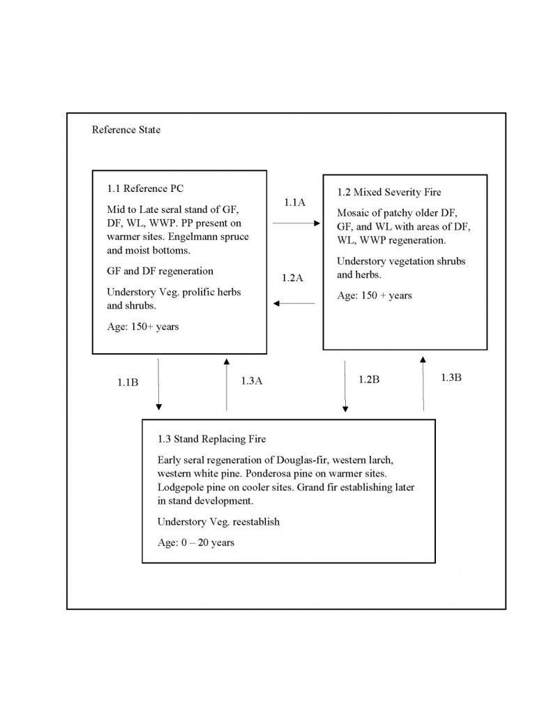
Click on box and path labels to scroll to the respective text.
Ecosystem states
State 1 submodel, plant communities
| 1.1A | - | Mixed severity fire |
|---|---|---|
| 1.1B | - | Stand replacing fire |
| 1.2A | - | Time |
| 1.2B | - | Time |
| 1.3A | - | Time |
| 1.3B | - | Time |
