Natural Resources
Conservation Service
Ecological site F006XD006WA
Cold Cryic Xeric Mountain Slopes (Whitebark Pine Cold Moderately Dry Shrub/Herb)
Last updated: 4/01/2025
Accessed: 02/07/2026
General information
Provisional. A provisional ecological site description has undergone quality control and quality assurance review. It contains a working state and transition model and enough information to identify the ecological site.
MLRA notes
Major Land Resource Area (MLRA): 006X–Cascade Mountains, Eastern Slope
Major Land Resource Area (MLRA): 006X–Cascade Mountains, Eastern Slope.
Stretching from northern Washington to southern Oregon, MLRA6 encompasses the mountain slopes, foothills, elevated plateaus and valleys on the eastern slopes of the Cascade mountains. This MLRA is a transitional area between the Cascade Mountains to the west and the lower lying Columbia Basalt Plateau to the east. Situated in the rain shadow of the Cascade Crest, this MLRA receives less precipitation than portions of the cascades further west and greater precipitation than the basalt plateaus to the east. Geologically, the majority of the MLRA is dominated by Miocene volcanic rocks, while the northern portion is dominated by Pre-Cretaceous metamorphic rocks and the southern portion is blanketed with a thick mantle of ash and pumice from Mount Mazama. The soils in the MLRA dominantly have a mesic, frigid, or cryic soil temperature regime, a xeric soil moisture regime, and mixed or glassy mineralogy. They generally are moderately deep to very deep, well drained, and loamy or ashy. Biologically, the MLRA is dominated by coniferous forest, large expanses of which are dominated by ponderosa pine, Douglas-fir or lodgepole pine. Areas experiencing cooler and moister conditions include grand fir, white fir, and western larch while the highest elevations include pacific silver fir, subalpine fir and whitebark pine. Economically, timber harvest and recreation are important land uses in these forests. Historically, many of these forests would have experienced relatively frequent, low and mixed severity fire favoring the development of mature forests dominated by ponderosa pine or Douglas-fir. In the southern pumice plateau forests, less frequent, higher severity fire was common and promoted the growth of large expanses of lodgepole pine forests.
LRU notes
This ecological site typically resides on mountain slopes and cirque floors, at elevations of 4900 to 7000 feet, on slopes of 35 to 75 percent.
Classification relationships
The ecological site relates to the Wenatchee National Forest plant associations:
CAS311- Whitebark pine/grouse huckleberry/smooth woodrush (PIAL/VASC/LUHI)
CAF321 - Whitebark pine/pinegrass (PIAL/CARU)
Ecological site concept
This ecological site typically resides on mountain slopes and cirque floors, at elevations of 4900 to 7000 feet, on slopes of 35 to 75 percent. The climate is cold and holds a heavy, persistent snowpack, with 55 to 80 frost-free days, mean annual precipitation of 30 to 55 inches, and mean annual air temperature is 37 to 41 degrees Fahrenheit.
The soils are typically Inceptisols, specifically Haploxerandic Haplocryepts, and Andisols, specifically Xeric Vitricryands. Particle-size classes are loamy-skeletal and ashy over loamy-skeletal, and surface textures ashy sandy loam and ashy loam. The parent material is volcanic ash over glacial till, colluvium, and residuum. The soils are well drained, and have no flooding, ponding or water table. They are typically 20 to greater than 60 inches deep to a root-restricting feature. These soils have a cryic soil temperature regime and xeric soil moisture regime.
The reference community has an overstory of PIAL and an understory of VASC and LUHI4 and CARU. Seral tree species include ABGR, ABLA, LAOC, PICO, PIEN. The understory can include VASC, LUGLH, ACMI2, CAGE2, CARO5, CARU, FEVI, PAMY, VAMY2.
This ecological site is defined as the highest extent of open canopy forest, above this trees grow in clumps. Harsh site conditions of high wind, deep and persistent snowpack and short growing season allow Pinus albicaulis to be the dominant tree species in the overstory of this open canopy forest with an understory of cold adapted species including: Arnica latifolia, Polemonium pulcherrimum, Calamagrostis rubescens, Vaccinium myrsinites, Vaccinium scopulorum, Luzula hitchcockii. At the highest elevations this relegates tree species to grow only in clumps within an alpine meadow. The understory species are adapted to site conditions and vary from drier areas with Calamagrostis rubescens, Festuca viridis and moister areas with Vaccinium scopulorum, Arnica latifolia, Polemonium pulcherrimum, and Luzula hitchcockii. The site conditions are the main limiting factor to tree growth, though rare stand replacing fire can occur at intervals of 300 years, based on the LANDFIRE models for Pinus albicaulis. Numerous lightning strikes can occur on this site, particularly on ridges, but the lack of continuous tree canopy and low fuels preclude fire spread and severity.
Associated sites
| F006XA003WA |
Cryic Xeric Mountain Slopes (Subalpine fir Cool Moderately Dry Shrub/Herb) On warmer, lower elevation sites. |
|---|
Similar sites
| F006XA008WA |
Cryic Xeric Mountain Slopes (Subalpine fir Cold Moderately Dry Shrub/Herb) Lower elevation sites. |
|---|
Table 1. Dominant plant species
| Tree |
(1) Pinus albicaulis |
|---|---|
| Shrub |
(1) Vaccinium scoparium |
| Herbaceous |
(1) Luzula glabrata var. hitchcockii |
Click on box and path labels to scroll to the respective text.
Ecosystem states
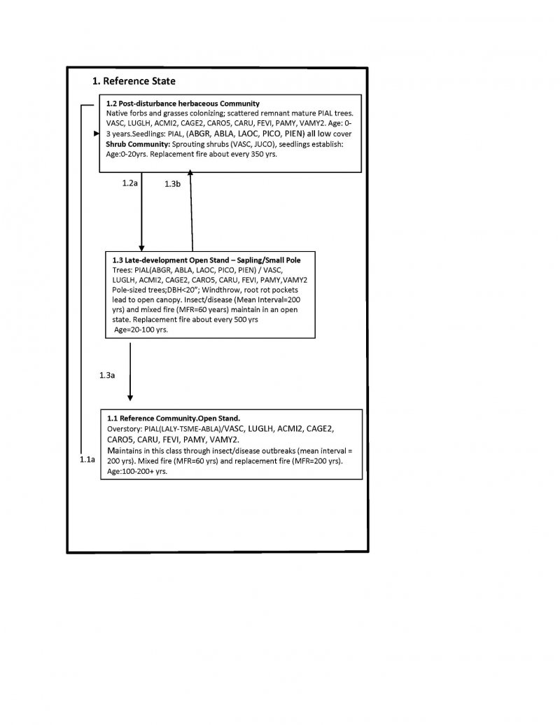
State 1 submodel, plant communities
| 1.1a | - | Rare, stand-replacement fire |
|---|---|---|
| 1.2a | - | Time with mixed severity fire |
| 1.3a | - | Time |
| 1.3b | - | Rare, stand-replacement fire |
