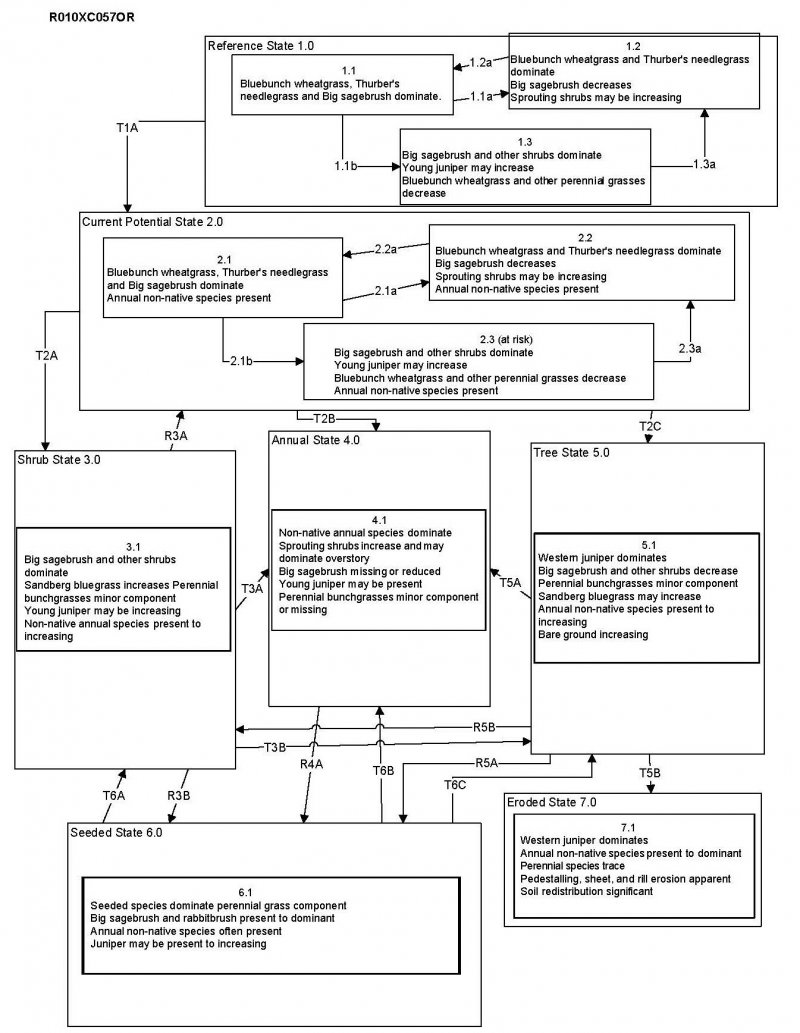
Ecological dynamics
In its reference condition, this site is dominated by bluebunch wheatgrass (Pseudoroegneria spicata), Thurber's needlegrass (Achnatherum thurberianum) and Wyoming big sagebrush (Artemisia tridentata ssp. wyomingensis). Wild crab apple (Peraphyllum ramosissimum) is a common shrub associate on this site. A diversity of forbs are also often present. Western juniper (Juniperus occidentalis) may be present in trace amounts, but under normal a disturbance regime is controlled by periodic fire.
Variability in site characteristics will alter plant composition. Needlegrasses increase over coarser textured soil surfaces. Wild crab apple increases over fractured soft tuffaceous sedimentary rock and diatomaceous earth. Antelope bitterbrush (Purshia tridentata) also increases over fractured substratums and on coarse textured soil surfaces. Despite the very shallow soils on this site, paralithic, fractured bedrock allows for Wyoming big sagebrush to persist on the site rather than species typically associated with very shallow soils such as rigid sagebrush.
Wyoming big sagebrush is fire intolerant species that is readily killed by most fires and does not resprout. It will be reduced on a site following fire and may be eliminated with frequent fires. Periodic insect outbreaks of Aroga moth (Aroga websteri) are an important component of the natural disturbance regime for big sagebrush, resulting in complete or partial mortality of sagebrush plants and potentially impacting thousands of acres (Innes 2019). Thurber's needlegrass is considered to be the least fire-resistant needlegrass, Thurber's is often damaged by moderately severe fire. It recovers slowly following fire and regenerates primarily by seed rather than resprouting from crowns (Archer 2000). Bluebunch wheatgrass is considered to be a highly fire adapted grass species with low buds often protected from fire. Recovery following fire is rapid and it often increases relative to other plants post fire, especially after spring burning. While burning may improve the nutritional quality of bluebunch, defoliation during the regeneration period can be very detrimental to the stand and grazing should be avoided immediately after (Zlatnik 1999).
Western juniper (Juniperus occidentalis) is a native conifer species in western North America but its density and range have dramatically increased since the late 1800s likely due to a combination of factors, namely: reductions in fire frequency; heavy livestock grazing; and increased atmospheric carbon dioxide (Fryer and Tirmenstein 2019). Juniper is sensitive to fire and most young trees are killed by even low severity fire. As Juniper trees mature and bark thickens, however, they become resistant to low severity fire yet are still killed by crown fires or high severity surface fires. Encroachment of juniper in the presence of an altered disturbance regime may have consequences for understory plant diversity and production, site hydrology and soil integrity with erosional states possible due to high levels of invasion.
Climate cycles would have been an important driver of ecological dynamics historically, with drought periods possibly leading to reductions in sagebrush cover and wet years increasing fire occurrence due to increased perennial grass production and fine fuels loads. Historically these communities would have likely encountered infrequent mixed and replacement severity fires with an average fire return interval of 50 years (yet with a high degree of variability depending on the site) (Landfire 2007). Livestock grazing has altered the plant community composition of much of the extent of this site.
If the site deteriorates in response to prolonged heavy grazing, big sagebrush, Sandberg bluegrass (Poa secunda) and bottlebrush squirreltail (Elymus elymoides) increase in plant density while bluebunch wheatgrass and Thurber's needlegrass decrease. Under an altered disturbance regime and degraded site conditions, invasions of exotic forb species and annual grass species may occur on this site. Exotic annual grasses such as cheatgrass (Bromus tectorum) and medusahead (Taeniatherum caput-medusae) may invade and become problematic. Exotic annual grass invasion may increase the size and frequency of fires and extend the season when fires are likely by augmenting early season fine fuel loads and fuel continuity. Sites may be particularly fire prone following years of above average precipitation during which invasive annual grass production can increase dramatically (Pilliod et al. 2017). In addition to exotic species, native shrub species such as broom snakeweed (Gutierrezia sarothrae) and rabbitbrush (Chrysothamnus spp.) may also increase following disturbance and may be important members of early seral communities.
An understanding of the site specific ecological dynamics for this site are incomplete. Thresholds between states and phases have yet to be quantified and restoration pathways and outcomes are not fully understood. Little is known about the ecological dynamics of wild crab apple and how it may respond to disturbance. Current and anticipated effects of climate change are not included in this model, yet this site may experience significant impacts as climate continues to change. The model below represents an approximation of ecological dynamics informed by disturbance response groups described in Stringham et al. 2017 and is likely to undergo refinements and revisions as more data becomes available. The reference plant community described below has been determined by study of rangeland relic areas or areas protected from excess disturbance.
State 1
Historic Reference
The Reference State is representative of the natural range of variability for the site under pristine conditions. The Reference State is a bunchgrass shrubland. State dynamics are maintained by interactions between climatic patterns and disturbance regimes. Negative feedbacks enhance ecosystem resilience and contribute to the stability of the state. These are maintained by ecosystem processes and structural elements such as the presence of all structural and functional plant groups, the retention of organic matter and the maintenance of plant community cover. Plant community phase changes are primarily driven by infrequent fire and periodic drought.
Community 1.1
Reference Community
The potential native plant community is dominated by bluebunch wheatgrass, Thurber's needlegrass, wild crab apple and Wyoming big sagebrush. Antelope bitterbrush is also present in the stand. Vegetative composition is about 70 percent grasses, 5 percent forbs and 25 percent shrubs.
Table 6. Annual production by plant type
| Plant type |
Low
(lb/acre) |
Representative value
(lb/acre) |
High
(lb/acre) |
| Grass/Grasslike |
70 |
219 |
290 |
| Shrub/Vine |
20 |
55 |
73 |
| Forb |
10 |
25 |
35 |
| Tree |
0 |
1 |
2 |
| Total |
100 |
300 |
400 |
Community 1.2
Perennial Bunchgrasses/Shrubs
Bluebunch wheatgrass and Thurber's needlegrass are dominant. Big sagebrush decreases. Sprouting shrubs may be increasing.
Community 1.3
Shrubs/Juniper
Big sagebrush and other shrubs are dominant. Young juniper may increase. Bluebunch wheatgrass and other perennial grasses decrease.
Pathway 1.1A
Community 1.1 to 1.2
Low severity fire resulting in a mosaic pattern; high severity fire leads to an early- and mid-seral community dominated by grasses and forbs, lacking sagebrush.
Pathway 1.1B
Community 1.1 to 1.3
Time and lack of disturbance such as fire facilitates and increase in the shrub overstory.
Pathway 1.2A
Community 1.2 to 1.1
Time and lack of disturbance such as fire allows for regeneration of the shrub and tree overstory.
Pathway 1.3A
Community 1.3 to 1.2
Low severity fire resulting in a mosaic pattern; high severity fire significantly reduces shrub cover and leads to a community dominated by grasses and forbs.
State 2
Current Potential
This state is similar to the Reference State. Ecological function has not changed fundamentally, however the resiliency of the site has been reduced by the presence of invasive plants. Additionally, livestock herbivory may be present as a disturbance process and changes in climate may be altering ecological dynamics. Non-native plant species may increase in abundance but will not become dominant or control ecological processes within this state. These species can be highly flammable and can promote fire where historically fire had been infrequent. Negative feedbacks enhance ecosystem resilience and contribute to the stability of the state. These are maintained by ecosystem processes and structural elements such as the presence of all structural and functional groups, and retention of organic matter and nutrients. Positive feedbacks driven by plant community invasion decrease ecosystem resilience and stability of the state. These include exotic plant species' high seed output, persistent seed bank, rapid growth rate, ability to cross pollinate, and adaptations for seed dispersal. Plant community phase changes are primarily driven by infrequent fire, periodic drought, and ungulate herbivory.
Current potential plant communities mirror those of the above Historical Reference (State 1) yet with the addition of a low level of invasive exotic plant invasion and influences of livestock herbivory. Livestock herbivory may result in decreases in deep rooted perennial grasses, and related increases in shallow-rooted perennial grasses (such as Sandberg's bluegrass), unpalatable forbs and shrubs.
Community 2.1
Perennial Bunchgrasses/Sagebrush/Annuals
Bluebunch wheatgrass, Thurber's needlegrass, and big sagebrush are dominant. Annual non-native species are present.
Community 2.2
Perennial Bunchgrasses/Shrubs/Annuals
Bluebunch wheatgrass and Thurber's needlegrass are dominant. Big sagebrush decreases. Sprouting shrubs may be increasing. Annual non-native species are present.
Community 2.3
Shrubs/Juniper/Annuals
Big sagebrush and other shrubs are dominant. Young juniper may increase. Bluebunch wheatgrass and other perennial grasses decrease. Annual non-native species are present.
Pathway 2.1A
Community 2.1 to 2.2
Low severity fire (ground fire) resulting in a mosaic pattern, brush treatments and tree thinning would also reduce the overstory allowing the perennial understory to increase; high severity fire significantly reduces sagebrush, and young juniper facilitating perennial bunchgrass understory.
Pathway 2.1B
Community 2.1 to 2.3
Time and lack of disturbance such as fire leads to increased shrub and juniper overstory and decreased perennial grass understory; may be coupled with drought and inappropriate grazing management.
Pathway 2.2A
Community 2.2 to 2.1
Time and lack of disturbance such as fire allows for regeneration of the shrub overstory.
Pathway 2.3A
Community 2.3 to 2.2
Low severity fire (ground fire) resulting in a mosaic pattern, brush treatments and tree thinning would also reduce the overstory; high severity fire significantly reduces sagebrush cover and leads to early- and mid-seral community dominated by grasses and forbs.
State 3
Shrub
Within this state, site resources are primarily controlled by shrub species. Native deep-rooted perennial grass composition has been reduced considerably, with shallow-rooted and disturbance adapted grasses such as Sandberg bluegrass increasing. Wyoming big sagebrush dominates the shrub overstory, with rabbitbrush, wild crab apple and antelope bitterbrush sometimes common. Exotic herbaceous species such as cheatgrass and medusahead are likely.
Sagebrush cover has increased beyond the natural range of variability for the site and may be decadent, reflecting stand maturity and lack of seedling establishment due to competition with mature plants. The dominance of site resources by the shrub overstory and Sandberg bluegrass understory leads to a temporal redistribution of soil water, nutrient capture, nutrient cycling and soil organic matter. Bare ground may be significant with soil redistribution occurring between interspace and shrub locations. Western juniper increases and may begin to influence the understory vegetation.
Community 3.1
Shrubs/Bluegrass
Big sagebrush and other shrubs are dominant. Sandberg bluegrass increases. Perennial bunchgasses are a minor component. Young juniper may be increasing. Non-native annual species are present to increasing.
State 4
Annual
Within this state, site resources are primarily controlled by exotic annual and perennial herbaceous species. Native perennial grass composition has been greatly diminished. Shrub species and western juniper may also be present.
Multiple plant communities are possible within this state, all of which are dominated by invasive annual grasses such as cheatgrass and medusahead and potentially invasive annual and perennial forbs. Sagebrush, wild crab apple, bitterbrush and rabbitbrush may be common in the overstory. Overtime, with increasing invasion, soil stabilizing perennial root biomass will be decreased. Bare ground will increase during winter, potentially increasing erosion even on this low to moderate slope site during extreme weather events.
Community 4.1
Annuals/Sprouting Shrubs
Non-native annual species are dominant. Sprouting shrubs increase and may be dominant in the overstory. Big sagebrush is missing or reduced. Young juniper may be present. Perennial bunchgrasses are a minor component or missing.
State 5
Tree
This state is characterized by a dominance of young juniper (less than 100 years old) in the overstory. Big sagebrush and perennial bunchgrasses may still be present, but they are no longer controlling site resources. Soil moisture, soil nutrients and soil organic matter distribution and cycling have been spatially and temporally altered. Juniper encroachment can decrease cover of perennial grasses and shrubs by reducing light availability and altering site hydrology through increased interception of precipitation, reduced infiltration and increased erosion. Bare ground will increase and erosion may be increased even on this low to moderately sloping site during extreme weather events.
Community 5.1
Juniper Woodland
Western juniper is dominant. Big sagebrush and other shrubs decrease. Perennial bunchgrasses are a minor component. Sandberg bluegrass may increase. Annual non-native species present to increasing. Bare ground is increasing.
State 6
Seeded
Within this state, site resources are primarily controlled by introduced range grasses such as crested wheatgrass (Agropyron cristatum) and intermediate wheatgrass (Thinopyrum intermedium). Multiple community phases may occur within this state and will include different compositions of native and introduced shrub and grass species. Western juniper may be present. Similar to ecological dynamics within other states of this site, shrub species and western juniper will increase with greater time since fire and herbivory pressure. While introduced range grasses may provide some analogous ecological functions to native perennial grasses, they may outcompete native grasses in the long-term.
Community 6.1
Seeded Grasses/Shrubs
Seeded species are dominant, perennial grass component. Big sagebrush and rabbitbrush present to dominant. Annual non-native species often present.Juniper may be present to increasing.
State 7
Eroded
This state is characterized by significant soil loss through wind and water erosion. Most herbaceous cover has been lost and soil stabilizing microbiotic soil crusts are degraded. Loss of these components reduces soil stability and renders the soil surface vulnerable to raindrop impacts, runoff and transport of soil by water and entrainment of soil particles by wind. Extensive areas of erosion pavement are common. Rill and gully formation may occur, especially toward the higher slope range of this site. Positive feedbacks develop as low vegetative cover leads to decreased litter and organic matter production, higher soil temperature variability, and decreased nutrient cycling, further destabilizing soil and decreasing potential plant establishment. Grass and forb vegetative cover is low yet invasive annual plants are likely and juniper cover is likely high. Potential for rehabilitation of this state is unknown but would likely pose significant challenges due to degradation of abiotic function of the site, the susceptibility of soils to erosion and damaging frost heaving, and mechanical limitations due to areas of rock outcrops and slopes.
Community 7.1
Juniper Woodland, Eroded
Western juniper is dominant. Annual non-native species present to dominant. Perennial species trace. Pedestalling, sheet, and rill erosion apparent. Soil redistribution significant.
Transition T1A
State 1 to 2
Introduction of non-native plants
Transition T2A
State 2 to 3
Chronic, inappropriate grazing management reduces perennial grasses and allows for an increase in shrub/tree specie. Fire or brush treatment/tree thinning; may be coupled with inappropriate grazing management. With fire suppression western juniper trees will increase.
Transition T2B
State 2 to 4
Catastrophic fire, failed rehabilitation attempt, inappropriate grazing management in the presence of non-native annuals or competitive increase in annual grasses through lack of active management.
Transition T2C
State 2 to 5
Time and lack of disturbance allows for maturation of the tree community. May be combined with inappropriate grazing management.
Restoration pathway R3A
State 3 to 2
Shrub and tree reduction treatments and seeding of desired native species.
Transition T3A
State 3 to 4
Catastrophic fire and/ or failed rehabilitation treatment or combination of both. Inappropriate grazing management in the presence of annual non-native species and competitive increase in annual grasses through lack of active management.
Transition T3B
State 3 to 5
Time and lack of disturbance allows for maturation of the tree community. May be combined with inappropriate grazing management.
Restoration pathway R3B
State 3 to 6
Shrub removal treatments and seeding of desired cultivated species. Herbicide may be necessary.
Restoration pathway R4A
State 4 to 6
Herbicide of annual species and seeding of desired species; may be coupled with brush management.
Restoration pathway R5B
State 5 to 3
Juniper stand removal and seeding of desired cultivated species: herbicide may be necessary.
Transition T5A
State 5 to 4
Juniper stand thinning or removal.
Restoration pathway R5A
State 5 to 6
Juniper stand thinning or removal.
Transition T5B
State 5 to 7
Time without disturbance allows for trees to outcompete understory; bare ground allows for excess soil movement.
Transition T6A
State 6 to 3
Catastrophic fire, especially following high shrub and tree fuel accumulation. Inappropriate grazing facilitates decrease in bunchgrasses and increase in non-native annual grasses
Transition T6B
State 6 to 4
Chronic, heavy growing season grazing will decrease bunchgrasses, increase Sandberg bluegrass and shrubs. Severe fire likely following shrub and tree fuel accumulation.
Transition T6C
State 6 to 5
Time without disturbance allows for maturation of tree community.