Natural Resources
Conservation Service
Ecological site R023XY003NV
CLAY BASIN
Last updated: 4/10/2025
Accessed: 04/02/2026
General information
Provisional. A provisional ecological site description has undergone quality control and quality assurance review. It contains a working state and transition model and enough information to identify the ecological site.
Ecological site concept
Currently there is only a draft of the initial concept for this ecological site. The initial concept for this site places it within the Seasonally Flooded Closed Clay Basins Ecological Site Group. To view the General STM and other information available for this ESG please go to https://edit.jornada.nmsu.edu/catalogs/esg/023X/R023XY912NV
Clay Basin sites typically surround Wet Clay Basin sites. The site has slightly greater slopes (up to 2%) and have a greater depth to the water table. Clay basin sites typically do not pond water except during wet years, but depth to a seasonally high water table is typically less than 3 feet. Because of this, Clay Basin sites are more productive with 1500 lb/ac in normal years. The plant community is dominated by Nevada bluegrass, basin wildrye and creeping wildrye. Silver sagebrush may be a significant component and may be dominant depending on site history and recent climate. This site has three stable states: Reference, Current Potential, and Shrub. While the plant species and pathways are slightly different for this site, the site is like the group modal in that it is highly driven by hydrologic changes. Due to the
higher productivity of this site, it is more likely to be affected by fire during dry periods. After fire, silver sagebrush will sprout. During long-term drought events, silver sagebrush will be a larger component.
Associated sites
| R023XY023NV |
WET CLAY BASIN |
|---|---|
| R023XY082NV |
LOAMY FAN 10-12 P.Z. |
| R023XY090NV |
CLAY PLAIN |
Similar sites
| R023XY023NV |
WET CLAY BASIN Has standing water for longer periods; not a stable plant community; ARCA13 not prevalent |
|---|
Table 1. Dominant plant species
| Tree |
Not specified |
|---|---|
| Shrub |
(1) Artemisia cana |
| Herbaceous |
(1) Poa nevadensis |
Physiographic features
This site occurs on nearly level, enclosed basin floor remnants, alluvial flats, and depressions. Slope gradients are less than 2 percent. Elevations are 5300 to 7200 feet.
Table 2. Representative physiographic features
| Landforms |
(1)
Basin-floor remnant
(2) Alluvial flat (3) Depression |
|---|---|
| Flooding duration | Very brief (4 to 48 hours) to brief (2 to 7 days) |
| Flooding frequency | Rare to occasional |
| Ponding duration | Brief (2 to 7 days) to long (7 to 30 days) |
| Ponding frequency | Occasional to frequent |
| Elevation | 5,300 – 7,200 ft |
| Slope | 2% |
| Ponding depth | 12 in |
| Water table depth | 84 in |
| Aspect | Aspect is not a significant factor |
Climatic features
The climate associated with this site is semiarid and characterized by cold, moist winters and warm, dry summers. Average annual precipitation is 10 to 14 inches. Mean annual air temperature is 40 to 45 degrees F. The average growing season is about 80 to 100 days.
Nevada’s climate is predominantly arid, with large daily ranges of temperature, infrequent severe storms, heavy snowfall in the higher mountains, and great location variations with elevation. Three basic geographical factors largely influence Nevada’s climate: continentality, latitude, and elevation. Continentality is the most important factor. The strong continental effect is expressed in the form of both dryness and large temperature variations. Nevada lies on the eastern, lee side of the Sierra Nevada Range, a massive mountain barrier that markedly influences the climate of the State. The prevailing winds are from the west, and as the warm moist air from the Pacific Ocean ascend the western slopes of the Sierra Range, the air cools, condensation occurs and most of the moisture falls as precipitation. As the air descends the eastern slope, it is warmed by compression, and very little precipitation occurs. The effects of this mountain barrier are felt not only in the West but throughout the state, with the result that the lowlands of Nevada are largely desert or steppes. The temperature regime is also affected by the blocking of the inland-moving maritime air. Nevada sheltered from maritime winds, has a continental climate with well-developed seasons and the terrain responds quickly to changes in solar heating.
Nevada lies within the mid-latitude belt of prevailing westerly winds which occur most of the year. These winds bring frequent changes in weather during the late fall, winter and spring months, when most of the precipitation occurs. To the south of the mid-latitude westerlies, lies a zone of high pressure in subtropical latitudes, with a center over the Pacific Ocean. In the summer, this high-pressure belt shifts northward over the latitudes of Nevada, blocking storms from the ocean. The resulting weather is mostly clear and dry during the summer and early fall, with scattered thundershowers. The eastern portion of the state receives significant summer thunderstorms generated from monsoonal moisture pushed up from the Gulf of California, known as the North American monsoon. The monsoon system peaks in August and by October the monsoon high over the Western U.S. begins to weaken and the precipitation retreats southward towards the tropics (NOAA 2004).
Average annual precipitation is 16 to over 20 inches. Mean annual air temperature is 41 to 44 degrees F. The average growing season is about 50 to 70 days.
Mean annual precipitaion at the Bear Creek, Nevada SNOTEL station (170501020301) is 37.69 inches.
monthly mean precipitation is:
January 3.84; February 3.75; March 4.38; April 4.9;
May 3.99; June 2.82; July .95; August 1.66;
September 1.22; October 2.12;
November 3.67; December 4.38.
Table 3. Representative climatic features
| Frost-free period (average) | 90 days |
|---|---|
| Freeze-free period (average) | |
| Precipitation total (average) | 12 in |
Figure 1. Monthly precipitation range
Figure 2. Monthly average minimum and maximum temperature
Figure 3. Annual precipitation pattern
Figure 4. Annual average temperature pattern
Influencing water features
Depth to a seasonally-high water table varies but is generally less than 3 feet. These soils also receive additional moisture as run-in from higher landscapes.
Soil features
Soils associated with this site are generally very deep, dark colored, and self-churning. The soils are somewhat poorly to well drained and receive additional moisture as run-in from higher landscapes. When dry, the soils have frequent wide cracks into which granulated surface layers tend to slough. Upon wetting, the cracks close. This continual, active soil movement damages the root system of many plants. Depth to a seasonally-high water table varies but is generally less than 3 feet. In years of above average precipitation, these soils may be ponded during the early part of the growing season. The soil series associated with this site include: Boulder Lake, Jesse Camp, and Longdis.
Table 4. Representative soil features
| Surface texture |
(1) Silty clay (2) Very fine sandy loam (3) Silt loam |
|---|---|
| Family particle size |
(1) Clayey |
| Drainage class | Somewhat poorly drained to well drained |
| Permeability class | Very slow to moderately slow |
| Soil depth | 72 – 84 in |
| Surface fragment cover <=3" | 8% |
| Surface fragment cover >3" | Not specified |
| Available water capacity (0-40in) |
5.9 – 7 in |
| Calcium carbonate equivalent (0-40in) |
5% |
| Electrical conductivity (0-40in) |
8 mmhos/cm |
| Sodium adsorption ratio (0-40in) |
45 |
| Soil reaction (1:1 water) (0-40in) |
6.1 – 9 |
| Subsurface fragment volume <=3" (Depth not specified) |
2% |
| Subsurface fragment volume >3" (Depth not specified) |
Not specified |
Ecological dynamics
As ecological condition declines, Nevada bluegrass and creeping wildrye composition are reduced as silver sagebrush and rabbitbrush increase.
Fire Ecology:
Silver sagebrush steppes experience stand-replacement fires. Fire frequencies are uncertain: fire histories for silver sagebrush communities are sparse to altogether lacking. Since plant productivity and community structure vary across the species' wide geographical distribution, historic fire intervals were probably similarly varied. Surface fires top kills silver sagebrush. Silver sagebrush has a strong sprouting response after top kill fire. Because perennating buds on rhizomes and roots are protected by soil, silver sagebrush ordinarily survives even severe surface fires. Fall burning is harder on silver sagebrush than spring burning. Rubber rabbitbrush is often top-killed by fire. Rubber rabbitbrush is a fire-adapted species that is typically unharmed or enhanced by fire. Recovery time is often rapid to very rapid. Rubber rabbitbrush is often one of the first species to colonize burned areas by sprouting or from off-site seed. Nevada bluegrass is generally unharmed by fire. It produces little litter, and its small bunch size and sparse litter reduces the amount of heat transferred to perennating buds in the soil. Basin wildrye is top-killed by fire. Older basin wildrye plants with large proportions of dead material within the perennial crown can be expected to show higher mortality due to fire than younger plants having little debris. Basin wildrye is generally tolerant of fire but may be damaged by early season fire combined with dry soil conditions. Creeping wildrye is top-killed by fire. Creeping wildrye is generally tolerant of fire but may be damaged by early season fire combined with dry soil conditions.
State and transition model
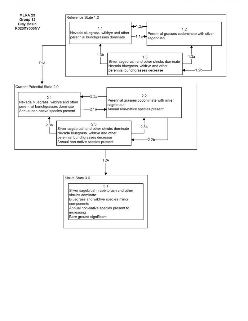

More interactive model formats are also available.
View Interactive Models
Click on state and transition labels to scroll to the respective text
Ecosystem states
State 1 submodel, plant communities
State 1
Reference Plant Community
Community 1.1
Reference Plant Community
The reference plant community is dominated by silver sagebrush, Nevada bluegrass and creeping wildrye. Mat muhly is an important species associated with this site. Potential vegetative composition is about 55% grasses, 10% forbs and 35% shrubs. Approximate ground cover (basal and crown) is about 20 to 35 percent.
Figure 5. Annual production by plant type (representative values) or group (midpoint values)
Table 5. Annual production by plant type
| Plant type | Low (lb/acre) |
Representative value (lb/acre) |
High (lb/acre) |
|---|---|---|---|
| Grass/Grasslike | 550 | 825 | 990 |
| Shrub/Vine | 350 | 525 | 630 |
| Forb | 100 | 150 | 180 |
| Total | 1000 | 1500 | 1800 |
Additional community tables
Table 6. Community 1.1 plant community composition
| Group | Common name | Symbol | Scientific name | Annual production (lb/acre) | Foliar cover (%) | |
|---|---|---|---|---|---|---|
|
Grass/Grasslike
|
||||||
| 1 | Primary Perennial Grasses | 900–1200 | ||||
| basin wildrye | LECI4 | Leymus cinereus | 112–150 | – | ||
| beardless wildrye | LETR5 | Leymus triticoides | 113–150 | – | ||
| mat muhly | MURI | Muhlenbergia richardsonis | 75–150 | – | ||
| 2 | Secondary Perennial Grasses | 150–225 | ||||
| sedge | CAREX | Carex | 8–75 | – | ||
| spikerush | ELEOC | Eleocharis | 8–75 | – | ||
| thickspike wheatgrass | ELLA3 | Elymus lanceolatus | 8–75 | – | ||
|
Forb
|
||||||
| 3 | Perennial | 75–150 | ||||
| povertyweed | IVAX | Iva axillaris | 8–45 | – | ||
| evening primrose | OENOT | Oenothera | 8–45 | – | ||
| dock | RUMEX | Rumex | 8–45 | – | ||
|
Shrub/Vine
|
||||||
| 4 | Primary Shrubs | 180–450 | ||||
| silver sagebrush | ARCA13 | Artemisia cana | 150–375 | – | ||
| rubber rabbitbrush | ERNAN5 | Ericameria nauseosa ssp. nauseosa var. nauseosa | 30–75 | – | ||
| 5 | Secondary Shrubs | 30–75 | ||||
| greasewood | SAVE4 | Sarcobatus vermiculatus | 8–15 | – | ||
Interpretations
Animal community
Livestock Interpretations:
This site is suitable for livestock grazing. Grazing management should be keyed to perennial grass production. Nevada bluegrass is a widespread forage grass. It is one of the earliest grasses in the spring and is sought by domestic livestock and several wildlife species. Nevada bluegrass is a palatable species, but its production is closely tied to weather conditions. It produces little forage in drought years, making it a less dependable food source than other perennial bunchgrasses. The early growth and abundant production of basin wildrye make it a valuable source of forage for livestock. It is important forage for cattle and is readily grazed by cattle and horses in early spring and fall. Though coarse-textured during the winter, basin wildrye may be utilized more frequently by livestock and wildlife when snow has covered low shrubs and other grasses. Creeping wildrye can be used for forage and is very palatable to all livestock. Once established it is very rhizomatous and maintains stands for many years. Livestock use of silver sagebrush is variable depending upon availability of palatable herbs. Domestic sheep generally browse silver sagebrush more heavily than cattle. Livestock may actually make greater use of silver sagebrush when there is ample grass to go with it. In general, livestock forage only lightly on rubber rabbitbrush during the summer, but winter use can be heavy in some locations. Fall use is variable, but flowers are often used by livestock. A few leaves and the more tender stems may also be used.
Stocking rates vary over time depending upon season of use, climate variations, site, and previous and current management goals. A safe starting stocking rate is an estimated stocking rate that is fine tuned by the client by adaptive management through the year and from year to year.
Wildlife Interpretations:
Silver sagebrush provides valuable habitat and forage for wildlife. Deer, pronghorn, bighorn sheep, and sage-grouse browse the foliage. Mule deer may browse silver sagebrush heavily when other forage is dormant. Silver sagebrush is also important on fall and winter ranges. Wildlife forage only lightly on rubber rabbitbrush during the summer, but winter use can be heavy in some locations. Fall use is variable, but flowers are often used by wildlife. A few leaves and the more tender stems may also be used. The forage value of rubber rabbitbrush varies greatly among subspecies and ecotypes. Nevada bluegrass is desirable for pronghorn antelope and mule deer in the spring and preferable in the spring, summer, and fall for elk and desirable as part of their winter range. Basin wildrye provides winter forage for mule deer, though use is often low compared to other native grasses. Basin wildrye provides summer forage for black-tailed jackrabbits. Because basin wildrye remains green throughout early summer, it remains available for small mammal forage for longer time than other grasses. Creeping wildrye is used for forage for many wildlife species and is often used for cover.
Hydrological functions
Rills and pedestals are rare. Slope gradients are typically less than 2% (1%) and water flow patterns are rare. Runoff is very slow with ponding common over most of the area. Frost heaving and shrink-swell soil activity that affects shallow rooted plants are not indicators of soil erosion. Gullies are none to rare in areas of this site that occur on stable landforms. Runoff is very slow and ponding occurs in many areas. Deep-rooted perennial grass plants [i.e., Nevada bluegrass & wildrye]) increase infiltration. Infiltration is slow once the surface soil is wetted. Shrub canopy and associated litter break raindrop impact and provide opportunity for snow catch and accumulation on site.
Recreational uses
Aesthetic value is derived from the diverse floral and faunal composition and the colorful flowering of wild flowers and shrubs during the spring and early summer. This site offers rewarding opportunities to photographers and for nature study. This site is used for camping and hiking and has potential for upland and big game hunting.
Other products
Tribes of the Great Basin used silver sagebrush branches as a fuelbed for roasting pinyon pinecones. Many tribes use the branches in ceremonial rites. Basin wildrye was used as bedding for various Native American ceremonies, providing a cool place for dancers to stand.
Other information
Silver sagebrush has potential as a soil stabilizer and for use in rangeland, wildlife and riparian restoration projects. Basin wildrye is useful in mine reclamation, fire rehabilitation and stabilizing disturbed areas. Its usefulness in range seeding, however, may be limited by initially weak stand establishment. Creeping wildrye is primarily used for reclamation of wet, saline soils.
Supporting information
Type locality
| Location 1: Washoe County, NV | |
|---|---|
| Township/Range/Section | T35N R18E S8 |
| Latitude | 40° 55′ 21″ |
| Longitude | 119° 59′ 9″ |
| General legal description | NE1/4 SE1/4, Approximately 7 air-miles west-south-west of Duck Flat, Desert Lake area, Washoe County, Nevada. |
Other references
Fire Effects Information System (Online; http://www.fs.fed.us/database/feis/plants/).
USDA-NRCS Plants Database (Online; http://www.plants.usda.gov).
Great Basin Ecological Site Development Project: State and Transition Models for Major Land Resource Area 23, Nevada and portions of California (Online; https://naes.agnt.unr.edu/PMS/Pubs/2019-4060.pdf)
Contributors
BH/SW/GKB
T Stringham (UNR under contract with BLM)
Approval
Kendra Moseley, 4/10/2025
Rangeland health reference sheet
Interpreting Indicators of Rangeland Health is a qualitative assessment protocol used to determine ecosystem condition based on benchmark characteristics described in the Reference Sheet. A suite of 17 (or more) indicators are typically considered in an assessment. The ecological site(s) representative of an assessment location must be known prior to applying the protocol and must be verified based on soils and climate. Current plant community cannot be used to identify the ecological site.
| Author(s)/participant(s) | GK BRACKLEY |
|---|---|
| Contact for lead author | State Rangeland Management Specialist |
| Date | 06/20/2006 |
| Approved by | Kendra Moseley |
| Approval date | |
| Composition (Indicators 10 and 12) based on | Annual Production |
Indicators
-
Number and extent of rills:
Rills are rare. -
Presence of water flow patterns:
Slope gradients are typically less than 2% (1%) and water flow patterns are rare. Runoff is very slow with ponding common over most of the area.
-
Number and height of erosional pedestals or terracettes:
Pedestals formed due to erosion are rare. Frost heaving and shrink-swell soil activity that affects shallow rooted plants are not indicators of soil erosion. -
Bare ground from Ecological Site Description or other studies (rock, litter, lichen, moss, plant canopy are not bare ground):
Bare ground ± 55%; surface rock fragments 5 to 15%; shrub canopy 15 to 30%; basal area for perennial herbaceous plants ± 10%. -
Number of gullies and erosion associated with gullies:
Gullies are none to rare in areas of this site that occur on stable landforms. -
Extent of wind scoured, blowouts and/or depositional areas:
None -
Amount of litter movement (describe size and distance expected to travel):
Fine litter (foliage from grasses and annual & perennial forbs) is expected to move the distance of slope length during intense summer convection storms or rapid snowmelt events. Persistent litter (large woody material) will remain in place except during catastrophic events. -
Soil surface (top few mm) resistance to erosion (stability values are averages - most sites will show a range of values):
Soil stability values should be 4 to 6 on the heavy clay surface soil textures found on this site. (To be field tested.) -
Soil surface structure and SOM content (include type of structure and A-horizon color and thickness):
Surface structure is typically thin to thick-platy at the immediate surface grading to massive below. Soil surface colors are light and soils having an ochric epipedon are typical. Organic matter of the surface 2 to 4 inches is typically 1 to 2.5 percent, dropping off quickly below. -
Effect of community phase composition (relative proportion of different functional groups) and spatial distribution on infiltration and runoff:
Runoff is very slow and ponding occurs in many areas. Deep-rooted perennial grass plants [i.e., Nevada bluegrass & wildrye]) increase infiltration. Infiltration is slow once the surface soil is wetted. Shrub canopy and associated litter break raindrop impact and provide opportunity for snow catch and accumulation on site. -
Presence and thickness of compaction layer (usually none; describe soil profile features which may be mistaken for compaction on this site):
Compacted layers are not typical. Platy or massive sub-surface horizons are not to be interpreted as compacted soil layers. -
Functional/Structural Groups (list in order of descending dominance by above-ground annual-production or live foliar cover using symbols: >>, >, = to indicate much greater than, greater than, and equal to):
Dominant:
Reference Plant Community: Deep-rooted, cool season, perennial bunchgrasses >> low shrubs (low sagebrush). (By above ground production)Sub-dominant:
Shallow-rooted, cool season, perennial grasses and grass-like plants = associated shrubs = deep-rooted, cool season, perennial forbs = fibrous, shallow-rooted, cool season, annual and perennial forbs. (By above ground production)Other:
Additional:
-
Amount of plant mortality and decadence (include which functional groups are expected to show mortality or decadence):
Dead branches within individual shrubs are somewhat common and standing dead shrub canopy material may be as much as 15% of total woody canopy; some of the mature bunchgrasses (<10%) have dead centers. -
Average percent litter cover (%) and depth ( in):
Between plant interspaces (±35%) and litter depth is <½ inch. -
Expected annual annual-production (this is TOTAL above-ground annual-production, not just forage annual-production):
For normal or average growing season (through May) ± 1500 lbs/ac; Spring moisture significantly affects total production. -
Potential invasive (including noxious) species (native and non-native). List species which BOTH characterize degraded states and have the potential to become a dominant or co-dominant species on the ecological site if their future establishment and growth is not actively controlled by management interventions. Species that become dominant for only one to several years (e.g., short-term response to drought or wildfire) are not invasive plants. Note that unlike other indicators, we are describing what is NOT expected in the reference state for the ecological site:
Cheatgrass, povertyweed, knapweeds, Russian thistle, annual mustards, foxtail barley, and tall whitetop are invaders on this site. -
Perennial plant reproductive capability:
All functional groups should reproduce in average (or normal) and above average growing season years.
Print Options
Sections
Font
Other
The Ecosystem Dynamics Interpretive Tool is an information system framework developed by the USDA-ARS Jornada Experimental Range, USDA Natural Resources Conservation Service, and New Mexico State University.
Click on box and path labels to scroll to the respective text.