
Natural Resources
Conservation Service
Ecological site R023XY082NV
LOAMY FAN 10-12 P.Z.
Last updated: 4/10/2025
Accessed: 04/18/2025
General information
Provisional. A provisional ecological site description has undergone quality control and quality assurance review. It contains a working state and transition model and enough information to identify the ecological site.
Ecological site concept
Currently there is only a draft of the initial concept for this ecological site. The initial concept for this site places it within the Clayey Mesic Plateaus 8-14 PZ Wyoming Big Sagebrush and Thurber's Needlegrass Ecological Site Group. To view the General STM and other information available for this ESG please go to https://edit.jornada.nmsu.edu/catalogs/esg/023X/R023XY909OR
This site occurs on axial-stream floodplains and inset fans. The soils on this site are very deep, well drained silt or very fine sandy loams that have formed in alluvium from mixed rock sources. They have medium runoff and are moderately permeable. Soils in this site receive additional moisture as run-in from higher landscapes. This site occurs on more moderate slopes than the modal site and is more productive than the modal site, ranging from 600 lb/ac to 1200 lb/ac. This plant community is dominated by bluegrasses, needlegrasses, and Wyoming or Basin big sagebrush. This site has not been seen on field visits for the group report, but likely has the same STM as the modal site.
Associated sites
R023XY013NV |
DRY MEADOW |
---|---|
R023XY020NV |
LOAMY 10-12 P.Z. |
R023XY031NV |
CLAYPAN 10-14 P.Z. |
R023XY090NV |
CLAY PLAIN |
Similar sites
R023XY026NV |
MAHOGANY SAVANNA PSSPS-ACTH7 codominant |
---|---|
R023XY009NV |
LOAMY BOTTOM 8-12 P.Z. LECI4 dominant grass; more productive site |
R023XY071NV |
ASHY LOAM 10-12 P.Z. FEID dominant grass |
R023XY097NV |
LOAMY FAN 8-10 P.Z. LECI4-ELLAL codominant; GRSP and SAVE4 common; less productive site |
F024XY051NV |
Pinus monophylla-Juniperus osteosperma/Artemisia nova/Achnatherum thurberianum ACHY-HECO26 codominant grasses; occurs on sand sheets |
Table 1. Dominant plant species
Tree |
Not specified |
---|---|
Shrub |
(1) Artemisia tridentata |
Herbaceous |
(1) Poa |
Physiographic features
This site occurs on lagoons, fan aprons, lake plains, and inset fans. Slope gradients range from 0 to 15 percent, but slopes of 0 to 2 are most typical. Elevations are 5500 to 6800 feet.
Table 2. Representative physiographic features
Landforms |
(1)
Flood plain
(2) Inset fan |
---|---|
Elevation | 5,500 – 6,800 ft |
Slope | 15% |
Aspect | Aspect is not a significant factor |
Climatic features
The climate associated with this site is semiarid and characterized by cool, moist winters and warm, dry summers. Average annual precipitation is 8 to 12 inches. Mean annual air temperature is 45 to 50 degrees F. The average growing season is about 80 to 110 days.
Nevada’s climate is predominantly arid, with large daily ranges of temperature, infrequent severe storms, heavy snowfall in the higher mountains, and great location variations with elevation. Three basic geographical factors largely influence Nevada’s climate: continentality, latitude, and elevation. Continentality is the most important factor. The strong continental effect is expressed in the form of both dryness and large temperature variations. Nevada lies on the eastern, lee side of the Sierra Nevada Range, a massive mountain barrier that markedly influences the climate of the State. The prevailing winds are from the west, and as the warm moist air from the Pacific Ocean ascend the western slopes of the Sierra Range, the air cools, condensation occurs and most of the moisture falls as precipitation. As the air descends the eastern slope, it is warmed by compression, and very little precipitation occurs. The effects of this mountain barrier are felt not only in the West but throughout the state, with the result that the lowlands of Nevada are largely desert or steppes. The temperature regime is also affected by the blocking of the inland-moving maritime air. Nevada sheltered from maritime winds, has a continental climate with well-developed seasons and the terrain responds quickly to changes in solar heating.
Nevada lies within the mid-latitude belt of prevailing westerly winds which occur most of the year. These winds bring frequent changes in weather during the late fall, winter and spring months, when most of the precipitation occurs. To the south of the mid-latitude westerlies, lies a zone of high pressure in subtropical latitudes, with a center over the Pacific Ocean. In the summer, this high-pressure belt shifts northward over the latitudes of Nevada, blocking storms from the ocean. The resulting weather is mostly clear and dry during the summer and early fall, with scattered thundershowers. The eastern portion of the state receives significant summer thunderstorms generated from monsoonal moisture pushed up from the Gulf of California, known as the North American monsoon. The monsoon system peaks in August and by October the monsoon high over the Western U.S. begins to weaken and the precipitation retreats southward towards the tropics (NOAA 2004).
Average annual precipitation is 16 to over 20 inches. Mean annual air temperature is 41 to 44 degrees F. The average growing season is about 50 to 70 days.
Mean annual precipitaion at the Bear Creek, Nevada SNOTEL station (170501020301) is 37.69 inches.
monthly mean precipitation is:
January 3.84; February 3.75; March 4.38; April 4.9;
May 3.99; June 2.82; July .95; August 1.66;
September 1.22; October 2.12;
November 3.67; December 4.38.
Table 3. Representative climatic features
Frost-free period (average) | 95 days |
---|---|
Freeze-free period (average) | |
Precipitation total (average) | 10 in |
Figure 1. Monthly precipitation range
Figure 2. Monthly average minimum and maximum temperature
Figure 3. Annual precipitation pattern
Figure 4. Annual average temperature pattern
Influencing water features
Many areas receive additional moisture as run-in from higher landscapes.
Soil features
Soils associated with this site are generally very deep, well drained, and have formed in alluvium from mixed rock sources. Surface textures are generally sandy loams or fine sandy loams. Soils have low to high runoff and have moderately slow to moderately rapid permeability. Many areas receive additional moisture as run-in from higher landscapes. The soil series associated with this site include: Orr and Paypoint.
Table 4. Representative soil features
Surface texture |
(1) Sandy loam (2) Very gravelly sandy loam (3) Gravelly fine sandy loam |
---|---|
Family particle size |
(1) Loamy |
Drainage class | Well drained |
Permeability class | Moderately slow to moderately rapid |
Soil depth | 72 – 84 in |
Surface fragment cover <=3" | 42% |
Surface fragment cover >3" | 4% |
Available water capacity (0-40in) |
3.7 – 9.1 in |
Calcium carbonate equivalent (0-40in) |
5% |
Electrical conductivity (0-40in) |
4 mmhos/cm |
Sodium adsorption ratio (0-40in) |
5 |
Soil reaction (1:1 water) (0-40in) |
6.1 – 9 |
Subsurface fragment volume <=3" (Depth not specified) |
3 – 45% |
Subsurface fragment volume >3" (Depth not specified) |
2% |
Ecological dynamics
As ecological condition declines, bluegrass and needlegrass composition are reduced as big sagebrush and rabbitbrush increase. With continued site degradation, bottlebrush squirreltail, Sandberg bluegrass, and thickspike wheatgrass become the only perennial grasses in the understory.
Fire Ecology:
Fire return intervals in basin big sagebrush are between 15 and 70 years. A naturally wide variation in fire frequency in this system is expected. Basin big sagebrush is readily killed when aboveground plant parts are charred by fire. Prolific seed production from nearby unburned plants coupled with high germination rates enables seedlings to establish rapidly following fire. Wyoming big sagebrush is killed by fire and establishes after fire from a seedbank; from seed produced by remnant plants that escaped fire; and from plants adjacent to the burn that seed in. Cusick’s bluegrass is unharmed to slightly harmed by light-severity fall fires. Cusick’s bluegrass regenerates after fire from seed and by tillering. Nevada bluegrass is generally unharmed by fire. It produces little litter, and its small bunch size and sparse litter reduces the amount of heat transferred to perennating buds in the soil. Thurber’s needlegrass is classified as moderately resistant, but depending on season of burn, phenology, and fire severity, this perennial bunchgrass is moderately to severely damaged by fire. Early season burning is more damaging to this needlegrass than late season burning. Western needlegrass is moderately damaged by fire. The recovery time is between 3 and 5 years. Basin wildrye is top-killed by fire. Older basin wildrye plants with large proportions of dead material within the perennial crown can be expected to show higher mortality due to fire than younger plants having little debris. Basin wildrye is generally tolerant of fire but may be damaged by early season fire combined with dry soil conditions.
State and transition model
More interactive model formats are also available.
View Interactive Models
Click on state and transition labels to scroll to the respective text
Ecosystem states
State 1 submodel, plant communities
State 1
Reference Plant Community
Community 1.1
Reference Plant Community
The reference plant community is dominated by basin big sagebrush or Wyoming big sagebrush, Nevada bluegrass, Cusick's bluegrass, and Thurber's and/or western needlegrass. Potential vegetative composition is about 70% grasses, 10% forbs and 20% shrubs. Approximate ground cover (basal and crown) is about 25 to 35 percent.
Figure 5. Annual production by plant type (representative values) or group (midpoint values)
Table 5. Annual production by plant type
Plant type | Low (lb/acre) |
Representative value (lb/acre) |
High (lb/acre) |
---|---|---|---|
Grass/Grasslike | 420 | 630 | 840 |
Shrub/Vine | 120 | 180 | 240 |
Forb | 60 | 90 | 120 |
Total | 600 | 900 | 1200 |
Additional community tables
Table 6. Community 1.1 plant community composition
Group | Common name | Symbol | Scientific name | Annual production (lb/acre) | Foliar cover (%) | |
---|---|---|---|---|---|---|
Grass/Grasslike
|
||||||
1 | Primary Perennial Grasses | 423–702 | ||||
Thurber's needlegrass | ACTH7 | Achnatherum thurberianum | 90–158 | – | ||
Cusick's bluegrass | POCUE2 | Poa cusickii ssp. epilis | 113–157 | – | ||
western needlegrass | ACOCO | Achnatherum occidentale ssp. occidentale | 90–157 | – | ||
basin wildrye | LECI4 | Leymus cinereus | 18–72 | – | ||
2 | Secondary Perennial Grasses/Grasslikes | 45–90 | ||||
sedge | CAREX | Carex | 5–27 | – | ||
squirreltail | ELEL5 | Elymus elymoides | 5–27 | – | ||
thickspike wheatgrass | ELLAL | Elymus lanceolatus ssp. lanceolatus | 5–27 | – | ||
prairie Junegrass | KOMA | Koeleria macrantha | 5–27 | – | ||
Sandberg bluegrass | POSE | Poa secunda | 5–27 | – | ||
Forb
|
||||||
3 | Perennial | 45–135 | ||||
lupine | LUPIN | Lupinus | 18–45 | – | ||
milkvetch | ASTRA | Astragalus | 5–27 | – | ||
tapertip hawksbeard | CRAC2 | Crepis acuminata | 5–27 | – | ||
Shrub/Vine
|
||||||
4 | Primary Shrubs | 90–180 | ||||
basin big sagebrush | ARTRT | Artemisia tridentata ssp. tridentata | 45–90 | – | ||
Wyoming big sagebrush | ARTRW8 | Artemisia tridentata ssp. wyomingensis | 45–90 | – | ||
5 | Secondary Shrubs | 18–45 | ||||
yellow rabbitbrush | CHVI8 | Chrysothamnus viscidiflorus | 5–18 | – | ||
rubber rabbitbrush | ERNAN5 | Ericameria nauseosa ssp. nauseosa var. nauseosa | 5–18 | – |
Interpretations
Animal community
Livestock Interpretations:
This site is suitable for livestock grazing. Grazing management should be keyed to perennial grass production. Cusick's bluegrass makes up only a small proportion of the biomass of the sagebrush communities in which it lives, but it is often taken preferentially by cattle, especially early in the season. Nevada bluegrass is a widespread forage grass. It is one of the earliest grasses in the spring and is sought by domestic livestock and several wildlife species. Nevada bluegrass is a palatable species, but its production is closely tied to weather conditions. It produces little forage in drought years, making it a less dependable food source than other perennial bunchgrasses. Thurber’s needlegrass species begin growth early in the year and remain green throughout a relatively long growing season. This pattern of development enables animals to use Thurber’s needlegrass when many other grasses are unavailable. Cattle prefer Thurber’s needlegrass in early spring before fruits have developed as it becomes less palatable when mature. Thurber’s needlegrasses are grazed in the fall only if the fruits are softened by rain. Western needlegrass has a spreading and deeply penetrating root system, which makes it resistant to trampling. The early growth and abundant production of basin wildrye make it a valuable source of forage for livestock. It is important forage for cattle and is readily grazed by cattle and horses in early spring and fall. Though coarse-textured during the winter, basin wildrye may be utilized more frequently by livestock and wildlife when snow has covered low shrubs and other grasses. Basin big sagebrush may serve as emergency food during severe winter weather, but it is not usually sought out by livestock. Livestock browse Wyoming big sagebrush, but may use it only lightly when palatable herbaceous species are available.
Stocking rates vary over time depending upon season of use, climate variations, site, and previous and current management goals. A safe starting stocking rate is an estimated stocking rate that is fine tuned by the client by adaptive management through the year and from year to year.
Wildlife Interpretations:
Basin big sagebrush is the least palatable of all the subspecies of big sagebrush. Basin big sagebrush is browsed by mule deer from fall to early spring, but is not preferred. Wyoming big sagebrush is preferred browse for wild ungulates. Pronghorn usually browse Wyoming big sagebrush heavily. Sagebrush-grassland communities provide critical sage-grouse breeding and nesting habitats. Meadows surrounded by sagebrush may be used as feeding and strutting grounds. Sagebrush is a crucial component of their diet year-round, and sage-grouse select sagebrush almost exclusively for cover. Sage-grouse prefer mountain big sagebrush and Wyoming big sagebrush communities to basin big sagebrush communities. Deer, elk, and mountain goat also use Cusick's bluegrass early in the season. The value of Cusick's bluegrass as cover for small animals has been rated as poor to fair. Nevada bluegrass is desirable for pronghorn antelope and mule deer in the spring and preferable in the spring, summer, and fall for elk and desirable as part of their winter range. Thurber needlegrass is valuable forage for wildlife. Western needlegrass provides valuable forage for many species of wildlife. Basin wildrye provides winter forage for mule deer, though use is often low compared to other native grasses. Basin wildrye provides summer forage for black-tailed jackrabbits. Because basin wildrye remains green throughout early summer, it remains available for small mammal forage for longer time than other grasses.
Hydrological functions
Runoff is low to high. Permeability is moderately slow to moderately rapid. Hydrologic soil group is C.
Recreational uses
Aesthetic value is derived from the diverse floral and faunal composition and the colorful flowering of wild flowers and shrubs during the spring and early summer. This site offers rewarding opportunities to photographers and for nature study. This site is used for camping and hiking and has potential for upland and big game hunting.
Other products
Some Native American peoples used the bark of big sagebrush to make rope and baskets. Native Americans made tea from big sagebrush leaves. They used the tea as a tonic, an antiseptic, for treating colds, diarrhea, and sore eyes and as a rinse to ward off ticks. Big sagebrush seeds were eaten raw or made into meal. Basin wildrye was used as bedding for various Native American ceremonies, providing a cool place for dancers to stand.
Other information
Basin big sagebrush shows high potential for range restoration and soil stabilization. Basin big sagebrush grows rapidly and spreads readily from seed. Wyoming big sagebrush is used for stabilizing slopes and gullies and for restoring degraded wildlife habitat, rangelands, mine spoils and other disturbed sites. It is particularly recommended on dry upland sites where other shrubs are difficult to establish. Basin wildrye is useful in mine reclamation, fire rehabilitation and stabilizing disturbed areas. Its usefulness in range seeding, however, may be limited by initially weak stand establishment.
Supporting information
Type locality
Location 1: Washoe County, NV | |
---|---|
Township/Range/Section | T47N R21E S33 |
UTM zone | N |
UTM northing | 282060 |
UTM easting | 4647768 |
Latitude | 41° 57′ 6″ |
Longitude | 119° 37′ 46″ |
General legal description | NW 1/4 SW 1/4, Southeast end of Macy Flat, Washoe County, Nevada. |
Other references
Fire Effects Information System (Online; http://www.fs.fed.us/database/feis/plants/).
USDA-NRCS Plants Database (Online; http://www.plants.usda.gov).
Great Basin Ecological Site Development Project: State and Transition Models for Major Land Resource Area 23, Nevada and portions of California (Online; https://naes.agnt.unr.edu/PMS/Pubs/2019-4060.pdf)
Contributors
GKB
T Stringham (UNR under contract with BLM)
Approval
Kendra Moseley, 4/10/2025
Rangeland health reference sheet
Interpreting Indicators of Rangeland Health is a qualitative assessment protocol used to determine ecosystem condition based on benchmark characteristics described in the Reference Sheet. A suite of 17 (or more) indicators are typically considered in an assessment. The ecological site(s) representative of an assessment location must be known prior to applying the protocol and must be verified based on soils and climate. Current plant community cannot be used to identify the ecological site.
Author(s)/participant(s) | P. NOVAK-ECHENIQUE |
---|---|
Contact for lead author | State Rangeland Management Specialist |
Date | 04/07/2014 |
Approved by | Kendra Moseley |
Approval date | |
Composition (Indicators 10 and 12) based on | Annual Production |
Indicators
-
Number and extent of rills:
Rills are rare. A few rills can be expected on steeper slopes in areas subjected to summer convection storms or rapid spring snowmelt. -
Presence of water flow patterns:
Water flow patterns are rare but can be expected in areas recently subjected to summer convection storms or rapid snowmelt, usually on steeper slopes. They are usually short (<1 m), stable and disconnected. -
Number and height of erosional pedestals or terracettes:
Pedestals are rare. Occurrence is usually limited to areas of water flow patterns. -
Bare ground from Ecological Site Description or other studies (rock, litter, lichen, moss, plant canopy are not bare ground):
Bare ground up to 40% depending on amount of surface rock fragments. -
Number of gullies and erosion associated with gullies:
None -
Extent of wind scoured, blowouts and/or depositional areas:
None -
Amount of litter movement (describe size and distance expected to travel):
Fine litter (foliage from grasses and annual & perennial forbs) expected to move distance of slope length during intense summer convection storms or rapid snowmelt events. Persistent litter (large woody material) will remain in place except during large rainfall events. -
Soil surface (top few mm) resistance to erosion (stability values are averages - most sites will show a range of values):
Soil stability values should be 3 to 6 on most soil textures found on this site. -
Soil surface structure and SOM content (include type of structure and A-horizon color and thickness):
Surface structure is typically thin to thick platy. Soil surface colors are browns and soils are typified by an ochric epipedon. Organic matter of the surface 2 to 4 inches is typically 1.25 to 3 percent dropping off quickly below. Organic matter content can be more or less depending on micro-topography. -
Effect of community phase composition (relative proportion of different functional groups) and spatial distribution on infiltration and runoff:
Perennial herbaceous plants (especially deep-rooted bunchgrasses [i.e., bluegrass & needlegrass]) slow runoff and increase infiltration. Shrub canopy and associated litter break raindrop impact and provide opportunity for snow catch and accumulation on site. -
Presence and thickness of compaction layer (usually none; describe soil profile features which may be mistaken for compaction on this site):
Compacted layers are none. Platy or massive sub-surface horizons or subsoil argillic horizons are not to be interpreted as compacted. -
Functional/Structural Groups (list in order of descending dominance by above-ground annual-production or live foliar cover using symbols: >>, >, = to indicate much greater than, greater than, and equal to):
Dominant:
Deep-rooted, cool season, perennial bunchgrassesSub-dominant:
tall shrubs (big sagebrush)>>associated shrubs>shallow-rooted, cool season, perennial bunchgrasses>deep-rooted, cool season, perennial forbs>fibrous, shallow-rooted, cool season, perennial and annual forbsOther:
Additional:
-
Amount of plant mortality and decadence (include which functional groups are expected to show mortality or decadence):
Dead branches within individual shrubs common and standing dead shrub canopy material may be as much as 25% of total woody canopy; some of the mature bunchgrasses (<20%) have dead centers. -
Average percent litter cover (%) and depth ( in):
Between plant interspaces (25 – 35%) and litter depth is ± 1/4 inch. -
Expected annual annual-production (this is TOTAL above-ground annual-production, not just forage annual-production):
For normal or average growing season (through mid-June) ± 900 lbs/ac; Favorable years ± 1100 lbs/ac, Unfavorable years ± 600 lbs/ac -
Potential invasive (including noxious) species (native and non-native). List species which BOTH characterize degraded states and have the potential to become a dominant or co-dominant species on the ecological site if their future establishment and growth is not actively controlled by management interventions. Species that become dominant for only one to several years (e.g., short-term response to drought or wildfire) are not invasive plants. Note that unlike other indicators, we are describing what is NOT expected in the reference state for the ecological site:
Potential invaders include cheatgrass, halogeton, Russian thistle, annual mustards, knapweeds, and western juniper. -
Perennial plant reproductive capability:
All functional groups should reproduce in average (or normal) and above average growing season years. Reduced growth and reproduction occur during drought years.
Print Options
Sections
Font
Other
The Ecosystem Dynamics Interpretive Tool is an information system framework developed by the USDA-ARS Jornada Experimental Range, USDA Natural Resources Conservation Service, and New Mexico State University.
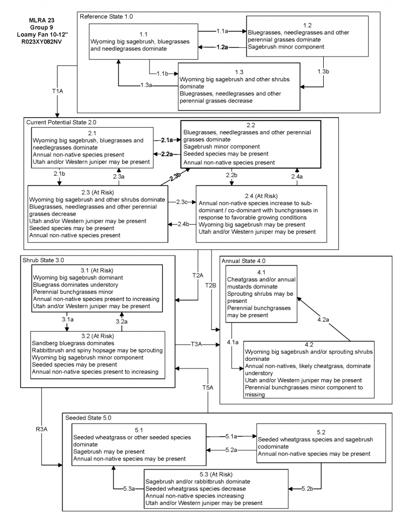
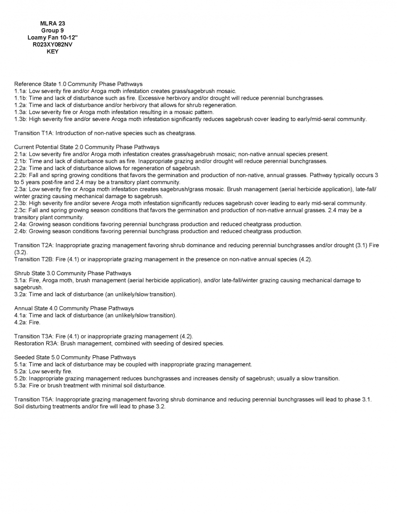
Click on box and path labels to scroll to the respective text.