Natural Resources
Conservation Service
Ecological site R023XY056NV
LOAMY BOTTOM 12-16 P.Z.
Last updated: 4/10/2025
Accessed: 04/03/2026
General information
Provisional. A provisional ecological site description has undergone quality control and quality assurance review. It contains a working state and transition model and enough information to identify the ecological site.
Ecological site concept
Currently there is only a draft of the initial concept for this ecological site. The initial concept for this site places it within the Seasonally Flooded Basin Wildrye Ecological Site Group. To view the General STM and other information available for this ESG please go to https://edit.jornada.nmsu.edu/catalogs/esg/023X/R023XY916NV
Mountain big sagebrush (Artemisia tridentata var. vaseyana) is the most common shrub on this site, however rubber rabbitbrush (Ericameria nauseosa), willow (Salix spp), and Wood’s rose (Rosa woodsii) may be present. Average production on a normal year is 1,700 lbs. per acre. This site was not seen during field visits for the group report and is mapped on fewer than 300 acres in MLRA 23.
Associated sites
| F023XY029NV |
POTR5/PONE3-CAREX-ELTR7 |
|---|---|
| R023XY013NV |
DRY MEADOW |
| R023XY019NV |
LOAMY 16+ P.Z. |
Similar sites
| R023XY013NV |
DRY MEADOW PONE3 dominant grass |
|---|---|
| R023XY009NV |
LOAMY BOTTOM 8-12 P.Z. lower precipitation zone; ARTRT dominant shrub; higher production |
Table 1. Dominant plant species
| Tree |
Not specified |
|---|---|
| Shrub |
(1) Artemisia tridentata ssp. vaseyana |
| Herbaceous |
(1) Leymus cinereus |
Physiographic features
This site occurs on inset fans and stream terraces in mountain valleys. Slopes range from 0 to 15 percent. Elevations are about 5000 to 8000 feet.
Table 2. Representative physiographic features
| Landforms |
(1)
Strath terrace
(2) Inset fan |
|---|---|
| Flooding duration | Very brief (4 to 48 hours) |
| Flooding frequency | Rare |
| Elevation | 5,000 – 8,000 ft |
| Slope | 15% |
| Water table depth | 30 – 60 in |
| Aspect | Aspect is not a significant factor |
Climatic features
The climate associated with this site is semiarid and characterized by cold, moist winters and warm, dry summers. Average annual precipitation is 12 to over 16 inches. Mean annual air temperature is 42 to 44 degrees F. The average growing season is about 60 to 100 days.
Nevada’s climate is predominantly arid, with large daily ranges of temperature, infrequent severe storms, heavy snowfall in the higher mountains, and great location variations with elevation. Three basic geographical factors largely influence Nevada’s climate: continentality, latitude, and elevation. Continentality is the most important factor. The strong continental effect is expressed in the form of both dryness and large temperature variations. Nevada lies on the eastern, lee side of the Sierra Nevada Range, a massive mountain barrier that markedly influences the climate of the State. The prevailing winds are from the west, and as the warm moist air from the Pacific Ocean ascend the western slopes of the Sierra Range, the air cools, condensation occurs and most of the moisture falls as precipitation. As the air descends the eastern slope, it is warmed by compression, and very little precipitation occurs. The effects of this mountain barrier are felt not only in the West but throughout the state, with the result that the lowlands of Nevada are largely desert or steppes. The temperature regime is also affected by the blocking of the inland-moving maritime air. Nevada sheltered from maritime winds, has a continental climate with well-developed seasons and the terrain responds quickly to changes in solar heating.
Nevada lies within the mid-latitude belt of prevailing westerly winds which occur most of the year. These winds bring frequent changes in weather during the late fall, winter and spring months, when most of the precipitation occurs. To the south of the mid-latitude westerlies, lies a zone of high pressure in subtropical latitudes, with a center over the Pacific Ocean. In the summer, this high-pressure belt shifts northward over the latitudes of Nevada, blocking storms from the ocean. The resulting weather is mostly clear and dry during the summer and early fall, with scattered thundershowers. The eastern portion of the state receives significant summer thunderstorms generated from monsoonal moisture pushed up from the Gulf of California, known as the North American monsoon. The monsoon system peaks in August and by October the monsoon high over the Western U.S. begins to weaken and the precipitation retreats southward towards the tropics (NOAA 2004).
Average annual precipitation is 16 to over 20 inches. Mean annual air temperature is 41 to 44 degrees F. The average growing season is about 50 to 70 days.
Mean annual precipitaion at the Bear Creek, Nevada SNOTEL station (170501020301) is 37.69 inches.
monthly mean precipitation is:
January 3.84; February 3.75; March 4.38; April 4.9;
May 3.99; June 2.82; July .95; August 1.66;
September 1.22; October 2.12;
November 3.67; December 4.38.
Table 3. Representative climatic features
| Frost-free period (average) | 80 days |
|---|---|
| Freeze-free period (average) | |
| Precipitation total (average) | 14 in |
Figure 1. Monthly precipitation range
Figure 2. Monthly average minimum and maximum temperature
Figure 3. Annual precipitation pattern
Figure 4. Annual average temperature pattern
Influencing water features
There are no influencing water features associated with this site.
Soil features
The soils associated with this site are formed in mixed alluvium and are very deep. They are well to somewhat poorly drained. Surface soils are thick, fertile and moderately fine to medium textured. The available water capacity is very low. Some soils have a seasonally high water table at depths of 30 to 60 inches which allows for significant fluctuations in herbage production. In some areas, this site occurs where a meadow has deteriorated due to stream channel entrenchment and resultant lowering of the water table. These soils are susceptible to gullying which intercepts normal overflow patterns causing site degradation. The soils are classified as Cumulic Haploxerolls, Fluventic Haploxerolls, or Pachic Haploxerolls.
Table 4. Representative soil features
| Surface texture |
(1) Loam (2) Stony loam (3) Very gravelly loam |
|---|---|
| Family particle size |
(1) Loamy |
| Drainage class | Well drained |
| Permeability class | Moderate |
| Soil depth | 72 – 84 in |
| Surface fragment cover <=3" | 50% |
| Surface fragment cover >3" | 5% |
| Available water capacity (0-40in) |
2.3 – 2.4 in |
| Calcium carbonate equivalent (0-40in) |
Not specified |
| Electrical conductivity (0-40in) |
Not specified |
| Sodium adsorption ratio (0-40in) |
Not specified |
| Soil reaction (1:1 water) (0-40in) |
6.1 – 7.8 |
| Subsurface fragment volume <=3" (Depth not specified) |
5 – 43% |
| Subsurface fragment volume >3" (Depth not specified) |
4 – 13% |
Ecological dynamics
Where management results in abusive livestock use, basin wildrye and the wheatgrass become less vigorous and subsequently decrease in composition. Mountain big sagebrush and rabbitbrush increase in the overstory as bluegrasses, sedge, rush, and wildiris increase in the understory. Thistles are plants likely to invade this site.
Fire Ecology:
Presettlement fire return intervals in mountain big sagebrush communities varied from 15 to 25 years. Plants are readily killed in all seasons, even light severity fires. Mountain big sagebrush is highly susceptible to injury from fire. It is often top-killed by fire and will not resprout. Basin wildrye is top-killed by fire. Older basin wildrye plants with large proportions of dead material within the perennial crown can be expected to show higher mortality due to fire than younger plants having little debris. Basin wildrye is generally tolerant of fire but may be damaged by early season fire combined with dry soil conditions. Streambank wheatgrass is quite tolerant of fire. Subsurface growing points and primarily rhizomatous reproduction may explain its ability to increase rapidly (within 2-5 years) following burning. The effects of fire on slender wheatgrass are dependent on its growth form. Tall, decadent plants with many leaves sustain the most fire damage, while those with short, sparse growth form, is the least likely to sustain damage to the root system during a fire. Nevada bluegrass is generally unharmed by fire. It produces little litter, and its small bunch size and sparse litter reduces the amount of heat transferred to perennating buds in the soil. Sedge is top-killed by fire, with rhizomes protected by insulating soil. The rhizomes of sedge species may be killed by high-severity fires that remove most of the soil organic layer. Reestablishment after fire occurs by seed establishment and/or rhizomatous spread.
State and transition model
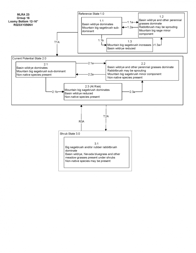

More interactive model formats are also available.
View Interactive Models
Click on state and transition labels to scroll to the respective text
State 1 submodel, plant communities
State 2 submodel, plant communities
State 3 submodel, plant communities
State 4 submodel, plant communities
State 5 submodel, plant communities
State 1
Reference State
Community 1.1
Community Phase
The reference plant community is dominated by basin wildrye, rhizomatous wheatgrasses and mountain big sagebrush. Potential vegetative composition is about 75% grasses, 10% forbs and 15% shrubs. Approximate ground cover (basal and crown) is about 40 to 60 percent.
Figure 5. Annual production by plant type (representative values) or group (midpoint values)
Table 5. Annual production by plant type
| Plant type | Low (lb/acre) |
Representative value (lb/acre) |
High (lb/acre) |
|---|---|---|---|
| Grass/Grasslike | 900 | 1275 | 1650 |
| Shrub/Vine | 180 | 255 | 330 |
| Forb | 120 | 170 | 220 |
| Total | 1200 | 1700 | 2200 |
Community 1.2
Community Phase
Community 1.3
Community Phase
Pathway a
Community 1.1 to 1.2
Pathway b
Community 1.1 to 1.3
Pathway a
Community 1.2 to 1.1
Pathway a
Community 1.3 to 1.2
State 2
Current Potential State
Community 2.1
Community Phase
Community 2.2
Community Phase
Community 2.3
Community Phase
Pathway a
Community 2.1 to 2.2
Pathway b
Community 2.1 to 2.3
Pathway a
Community 2.2 to 2.1
Pathway a
Community 2.3 to 2.2
State 3
Shrub State
Community 3.1
Community Phase
Community 3.2
Community Phase
Pathway a
Community 3.1 to 3.2
Pathway a
Community 3.2 to 3.1
State 4
Seeded State
Community 4.1
Community Phase
Community 4.2
Community Phase
Pathway a
Community 4.1 to 4.2
Pathway a
Community 4.2 to 4.1
State 5
Annual State
Community 5.1
Community Phase
Community 5.2
Community Phase
Pathway a
Community 5.1 to 5.2
Transition A
State 1 to 2
Transition A
State 2 to 3
Restoration pathway A
State 3 to 2
Restoration pathway B
State 3 to 4
Transition A
State 3 to 5
Additional community tables
Table 6. Community 1.1 plant community composition
| Group | Common name | Symbol | Scientific name | Annual production (lb/acre) | Foliar cover (%) | |
|---|---|---|---|---|---|---|
|
Grass/Grasslike
|
||||||
| 1 | Primary Perennial Grasses/Grasslikes | 833–1496 | ||||
| basin wildrye | LECI4 | Leymus cinereus | 680–1020 | – | ||
| slender wheatgrass | ELTRT | Elymus trachycaulus ssp. trachycaulus | 42–128 | – | ||
| thickspike wheatgrass | ELLA3 | Elymus lanceolatus | 43–127 | – | ||
| sedge | CAREX | Carex | 34–85 | – | ||
| 2 | Secondary Perennial Grasses/Grasslikes | 85–255 | ||||
| Columbia needlegrass | ACNEN2 | Achnatherum nelsonii ssp. nelsonii | 9–51 | – | ||
| western needlegrass | ACOCO | Achnatherum occidentale ssp. occidentale | 9–51 | – | ||
| mountain brome | BRMA4 | Bromus marginatus | 9–51 | – | ||
| beardless wildrye | LETR5 | Leymus triticoides | 9–51 | – | ||
|
Forb
|
||||||
| 3 | Perennial | 85–255 | ||||
| Rocky Mountain iris | IRMI | Iris missouriensis | 9–34 | – | ||
| lupine | LUPIN | Lupinus | 9–34 | – | ||
| beardtongue | PENST | Penstemon | 9–34 | – | ||
|
Shrub/Vine
|
||||||
| 4 | Primary Shrubs | 85–255 | ||||
| mountain big sagebrush | ARTRV | Artemisia tridentata ssp. vaseyana | 85–255 | – | ||
| 5 | Secondary Shrubs | 34–136 | ||||
| rubber rabbitbrush | ERNAN5 | Ericameria nauseosa ssp. nauseosa var. nauseosa | 17–51 | – | ||
| chokecherry | PRVI | Prunus virginiana | 17–51 | – | ||
| Woods' rose | ROWO | Rosa woodsii | 17–51 | – | ||
| willow | SALIX | Salix | 17–51 | – | ||
Interpretations
Animal community
Livestock Interpretations:
This site is suitable for livestock grazing. Grazing management should be keyed to perennial grass production. The early growth and abundant production of basin wildrye make it a valuable source of forage for livestock. It is important forage for cattle and is readily grazed by cattle and horses in early spring and fall. Though coarse-textured during the winter, basin wildrye may be utilized more frequently by livestock and wildlife when snow has covered low shrubs and other grasses. Streambank wheatgrass is palatable to all classes of livestock and wildlife. It is a preferred feed for cattle, sheep, horses, and elk in spring and is considered a desirable feed for deer and antelope in spring. It is considered a desirable feed for cattle, sheep, and horses in summer, fall, and winter. Streambank wheatgrass's extensive rhizome system allows established stands to withstand heavy grazing and trampling. Slender wheatgrass is grazed by all classes of livestock. Nevada bluegrass is a widespread forage grass. It is one of the earliest grasses in the spring and is sought by domestic livestock and several wildlife species. Nevada bluegrass is a palatable species, but its production is closely tied to weather conditions. It produces little forage in drought years, making it a less dependable food source than other perennial bunchgrasses. Sedge provides good to fair forage for domestic grazing. Mountain big sagebrush is eaten by domestic livestock but has long been considered to be of low palatability, and a competitor to more desirable species.
Stocking rates vary over time depending upon season of use, climate variations, site, and previous and current management goals. A safe starting stocking rate is an estimated stocking rate that is fine tuned by the client by adaptive management through the year and from year to year.
Wildlife Interpretations:
Mountain big sagebrush is highly preferred and nutritious winter forage for mule deer and elk. Sagebrush-grassland communities provide critical sage-grouse breeding and nesting habitats. Meadows surrounded by sagebrush may be used as feeding and strutting grounds. Sagebrush is a crucial component of their diet year-round, and sage-grouse select sagebrush almost exclusively for cover. Sage-grouse prefer mountain big sagebrush and Wyoming big sagebrush communities to basin big sagebrush communities. Basin wildrye provides winter forage for mule deer, though use is often low compared to other native grasses. Basin wildrye provides summer forage for black-tailed jackrabbits. Because basin wildrye remains green throughout early summer, it remains available for small mammal forage for longer time than other grasses. In the spring, steambank wheatgrass is a preferred feed for elk and is considered desirable feed for deer and antelope. It is desirable feed for elk during summer, fall, and winter. Streambank wheatgrass is also a component of black-tailed jackrabbit diets. Streambank wheatgrass provides some cover for small mammals and birds. Slender wheatgrass is grazed by sage grouse, deer, elk, moose, and bighorn sheep, mountain goat, pronghorn, various rodents, and all classes of livestock. The seeds are eaten by various seed predators. Slender wheatgrass provides hiding and thermal cover for songbirds, upland game birds, waterfowl, and small mammals. Nevada bluegrass is desirable for pronghorn antelope and mule deer in the spring and preferable in the spring, summer, and fall for elk and desirable as part of their winter range. Sedges have a high to moderate resource value for elk and a medium value for mule deer. Elk consume beaked sedge later in the growing season.
Hydrological functions
Runoff is low. Permeability is moderate. Hydrologic soil group is B.
Recreational uses
Aesthetic value is derived from the diverse floral and faunal composition and the colorful flowering of wild flowers and shrubs during the spring and early summer. This site offers rewarding opportunities to photographers and for nature study. This site is used for camping and hiking and has potential for upland and big game hunting.
Other products
Native Americans used big sagebrush leaves and branches for medicinal teas, and the leaves as a fumigant. Bark was woven into mats, bags and clothing. Basin wildrye was used as bedding for various Native American ceremonies, providing a cool place for dancers to stand.
Other information
Basin wildrye is useful in mine reclamation, fire rehabilitation and stabilizing disturbed areas. Its usefulness in range seeding, however, may be limited by initially weak stand establishment.
Supporting information
Other references
Fire Effects Information System (Online; http://www.fs.fed.us/database/feis/plants/).
USDA-NRCS Plants Database (Online; http://www.plants.usda.gov).
Great Basin Ecological Site Development Project: State and Transition Models for Major Land Resource Area 23, Nevada and portions of California (Online; https://naes.agnt.unr.edu/PMS/Pubs/2019-4060.pdf)
Contributors
CP/SW
T Stringham (UNR under contract with BLM)
Approval
Kendra Moseley, 4/10/2025
Rangeland health reference sheet
Interpreting Indicators of Rangeland Health is a qualitative assessment protocol used to determine ecosystem condition based on benchmark characteristics described in the Reference Sheet. A suite of 17 (or more) indicators are typically considered in an assessment. The ecological site(s) representative of an assessment location must be known prior to applying the protocol and must be verified based on soils and climate. Current plant community cannot be used to identify the ecological site.
| Author(s)/participant(s) | |
|---|---|
| Contact for lead author | |
| Date | 04/11/2025 |
| Approved by | Kendra Moseley |
| Approval date | |
| Composition (Indicators 10 and 12) based on | Annual Production |
Indicators
-
Number and extent of rills:
-
Presence of water flow patterns:
-
Number and height of erosional pedestals or terracettes:
-
Bare ground from Ecological Site Description or other studies (rock, litter, lichen, moss, plant canopy are not bare ground):
-
Number of gullies and erosion associated with gullies:
-
Extent of wind scoured, blowouts and/or depositional areas:
-
Amount of litter movement (describe size and distance expected to travel):
-
Soil surface (top few mm) resistance to erosion (stability values are averages - most sites will show a range of values):
-
Soil surface structure and SOM content (include type of structure and A-horizon color and thickness):
-
Effect of community phase composition (relative proportion of different functional groups) and spatial distribution on infiltration and runoff:
-
Presence and thickness of compaction layer (usually none; describe soil profile features which may be mistaken for compaction on this site):
-
Functional/Structural Groups (list in order of descending dominance by above-ground annual-production or live foliar cover using symbols: >>, >, = to indicate much greater than, greater than, and equal to):
Dominant:
Sub-dominant:
Other:
Additional:
-
Amount of plant mortality and decadence (include which functional groups are expected to show mortality or decadence):
-
Average percent litter cover (%) and depth ( in):
-
Expected annual annual-production (this is TOTAL above-ground annual-production, not just forage annual-production):
-
Potential invasive (including noxious) species (native and non-native). List species which BOTH characterize degraded states and have the potential to become a dominant or co-dominant species on the ecological site if their future establishment and growth is not actively controlled by management interventions. Species that become dominant for only one to several years (e.g., short-term response to drought or wildfire) are not invasive plants. Note that unlike other indicators, we are describing what is NOT expected in the reference state for the ecological site:
-
Perennial plant reproductive capability:
Print Options
Sections
Font
Other
The Ecosystem Dynamics Interpretive Tool is an information system framework developed by the USDA-ARS Jornada Experimental Range, USDA Natural Resources Conservation Service, and New Mexico State University.
Click on box and path labels to scroll to the respective text.