Natural Resources
Conservation Service
Ecological site R024XY008NV
SODIC FLAT 8-10 P.Z.
Last updated: 3/07/2025
Accessed: 04/10/2026
General information
Provisional. A provisional ecological site description has undergone quality control and quality assurance review. It contains a working state and transition model and enough information to identify the ecological site.
MLRA notes
Major Land Resource Area (MLRA): 024X–Humboldt Basin and Range Area
Major Land Resource Area (MLRA): 024X–Humboldt Basin and Range Area
Major land resource area (MLRA) 24, the Humboldt Area, covers an area of approximately 8,115,200 acres (12,680 sq. mi.). MLRA 24 is in the Great Basin Section of the Basin and Range Province of the Intermontane Plateaus. Elevations predominantly range from 3,950 to 5,900 feet (1,205 to 1,800 meters). The elevations of some mountain peaks are more than 8,850 feet (2,700 meters).
A series of widely spaced north-south trending mountain ranges are separated by broad valleys filled with alluvium washed in from adjacent mountain ranges. Most valleys are drained by tributaries to the Humboldt River. Playas, however, occur in lower elevation valleys with closed drainage systems. Isolated ranges are dissected, uplifted fault-block mountains.
Geology is comprised of Mesozoic and Paleozoic volcanic rock and marine and continental sediments. Young andesite and basalt flows (6 to 17 million years old) are at the margins of the mountains.
Dominant soil orders include Aridisols, Entisols, Inceptisols and Mollisols. Soils of the area are generally characterized by a mesic soil temperature regime, an aridic soil moisture regime and mixed geology. They are generally well drained, loamy and very deep.
75 percent of MLRA 24 is federally owned. The remainder is primarily used for farming, ranching and mining. Irrigated land comprises 3 percent of the area; most of the irrigation water is from surface water sources, such as the Humboldt River and Rye Patch Reservoir.
Annual precipitation typically ranges from 6 to 12 inches (15 to 30 cm) for most of the area. In the mountains however the precipitation may be up to 40 inches (101 cm). Most of the annual precipitation is from snow in the winter. In the spring and fall, rainfall occurs as high- intensity, convective thunderstorms.
Nevada is on the eastern, lee side of the Sierra Nevada Range; a massive mountain barrier that markedly influences the climate of the State. The prevailing winds are from the west. The warm moist air from the Pacific Ocean ascends the western slopes of the Sierra Range, the air cools, condenses and the moisture falls as precipitation. As the air descends the eastern slope, it is warmed by compression, and very little precipitation occurs. The effects of this mountain barrier are felt not only in the west but throughout the State. The result is the lowlands of
Ecological site concept
This ecological site is on alluvial flats. Soils are deep, poorly to somewhat poorly drained, and formed in alluvium derived from mixed rocks with a component of volcanic ash. The soil profile is characterized by an ochric epipdeon, a pH greater than 8.0 throughout, sodicity (SAR) greater than 30 and a water table between 90 to 150cm at some point during the spring. Soil textures are fine sandy loam or silt clay loam.
Important abiotic factors include crusting & baking of the surface layer upon drying, inhibiting water infiltration and seedling emergence. High salt concentrations reduce seed viability, germination and the available water capacity of these soils. Full consideration should be given to combining this ecological site concept with Sodic Flat 6-8" PZ (024XY011NV), and Dry Sodic Floodplain (024XY112OR). These sites may not compete on soil characteristics, abiotic factors or species composition.
Associated sites
| R024XY007NV |
SALINE BOTTOM Saline Bottom ecological site is on alluvial flats, stream terraces and flood plains. Soils are very deep, somewhat poorly drained and formed in alluvium derived from mixed alluvium, loess and volcanic ash. Dominant plant species are greasewood (SAVE4) and basin wildrye (LEXI4). |
|---|---|
| R024XY006NV |
DRY FLOODPLAIN The plant community is dominated by basin wildrye (LEXI4). Big sagebrush (ARTRT) is an important associated species. Important abiotic factors associated with this site include silt loam soil textures resulting in increased water holding capacity. |
Similar sites
| R024XY011NV |
SODIC FLAT 6-8 P.Z. Less productive site; typically occurs on basin floor adjacent to playa, not along axial-streams. |
|---|---|
| R024XY006NV |
DRY FLOODPLAIN Soils are very deep and a landform position that experiences rare flooding and concentrates run-in moisture. Big sagebrush (ARTR2) dominant shrub; Greasewood (SAVE4) minor shrub, or absent. |
| R024XY007NV |
SALINE BOTTOM This ecological site includes sodicity, and high amounts of soluble salts in the profile. More productive site; Basin wildrye (LECI4) dominant plant. |
Table 1. Dominant plant species
| Tree |
Not specified |
|---|---|
| Shrub |
(1) Sarcobatus vermiculatus |
| Herbaceous |
(1) Leymus cinereus |
Physiographic features
This site typically is on lake plains, alluvial flats and lake terraces. Slopes range from 0 to 8 percent, but slope gradients of 0 to 2 percent are most typical. Elevations are 3900 to 5800 feet (1189 to 1768 meters).
Table 2. Representative physiographic features
| Landforms |
(1)
Lake plain
(2) Alluvial flat (3) Lake terrace |
|---|---|
| Runoff class | Low to medium |
| Ponding duration | Very brief (4 to 48 hours) to long (7 to 30 days) |
| Ponding frequency | Rare to occasional |
| Elevation | 3,900 – 5,800 ft |
| Slope | 2% |
| Water table depth | 39 – 72 in |
| Aspect | Aspect is not a significant factor |
Climatic features
The climate associated with this site is semiarid and characterized by cool, moist winters and warm, dry summers. Average annual precipitation is 8 to 10 inches (20 to 25 cm) Mean annual air temperature is 45 to 50 degrees F. The average growing season is about 90 to 120 days.
Table 3. Representative climatic features
| Frost-free period (average) | 105 days |
|---|---|
| Freeze-free period (average) | |
| Precipitation total (average) | 10 in |
Figure 1. Monthly precipitation range
Figure 2. Monthly average minimum and maximum temperature
Influencing water features
This site is associated with lake plains and is subjected to flooding or ponding.
Soil features
The soils associated with this site are deep to very deep, poorly to somewhat poorly drained, and formed in alluvium derived from mixed rocks with a component of volcanic ash. The soil profile is characterized by an ochric epipdeon, a pH greater than 8.0 throughout and a water table between 90 to 150cm at some point during the spring. Sodicity (SAR) is greater than 30 and soil surface will crust on drying. Soil textures are fine sandy loam or silt clay loam.
The upper portion of these soils is strongly salt and sodium affected due to capillary movement of dissolved salts upward from the ground water. Effective rooting depths are limited by a fluctuating water table. Ponding from run-on water is common. Potential for sheet and rill erosion is slight to moderate. Soil series associated with this site include: Cluro, Gund, Moranch, Ocala, and Updike.
Table 4. Representative soil features
| Parent material |
(1)
Alluvium
(2) Volcanic ash |
|---|---|
| Surface texture |
(1) Silt loam (2) Loam (3) Sandy loam |
| Family particle size |
(1) Loamy |
| Drainage class | Somewhat poorly drained to well drained |
| Permeability class | Slow to moderately slow |
| Soil depth | 72 – 84 in |
| Surface fragment cover <=3" | 4% |
| Surface fragment cover >3" | Not specified |
| Available water capacity (0-40in) |
6.5 – 7.9 in |
| Calcium carbonate equivalent (0-40in) |
25% |
| Electrical conductivity (0-40in) |
2 – 32 mmhos/cm |
| Sodium adsorption ratio (0-40in) |
30 – 90 |
| Soil reaction (1:1 water) (0-40in) |
7.4 – 9.6 |
| Subsurface fragment volume <=3" (Depth not specified) |
44% |
| Subsurface fragment volume >3" (Depth not specified) |
Not specified |
Ecological dynamics
An ecological site is the product of all the environmental factors responsible for its development and it has a set of key characteristics that influence a site’s resilience to disturbance and resistance to invasives. Key characteristics include 1) climate (precipitation, temperature), 2) topography (aspect, slope, elevation, and landform), 3) hydrology (infiltration, runoff), 4) soils (depth, texture, structure, organic matter), 5) plant communities (functional groups, productivity), and 6) natural disturbance regime (fire, herbivory, etc.) (Caudle 2013). Biotic factors that influence resilience include site productivity, species composition and structure, and population regulation and regeneration (Chambers et al. 2013).
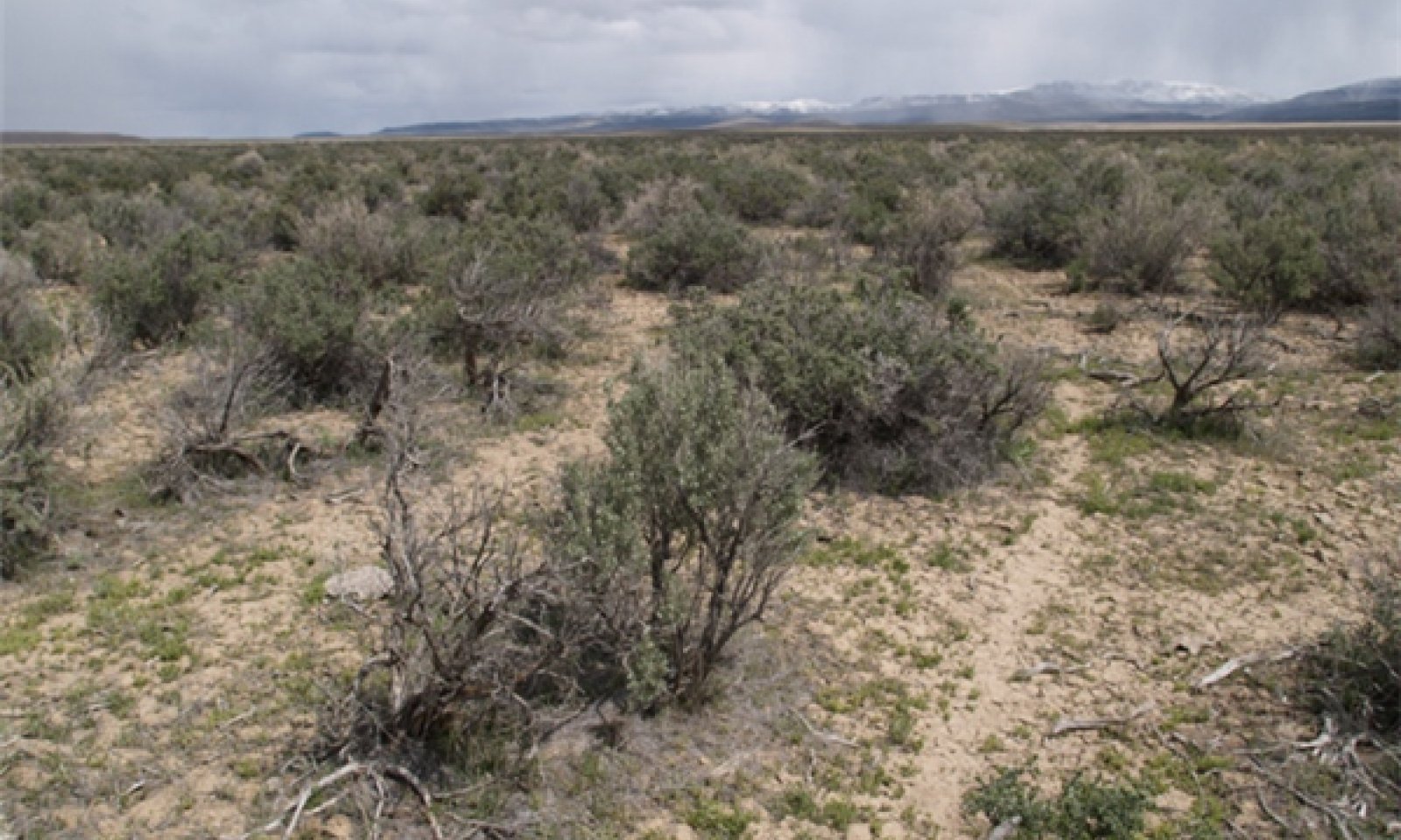
This ecological site is dominated by black greasewood with an understory of basin wildrye. Inland saltgrass and alkali sacaton are also common on these sites.
Black greasewood is classified as a phreatophyte (Eddleman 2002), and its distribution is well correlated with the distribution of groundwater (Mozingo 1987). Meinzer (1927) discovered that the taproots of black greasewood could penetrate from 20 to 57 feet (6 to17 meters) below the surface.
Romo (1984) observed water tables ranging from 3.5-15 m under black greasewood dominated communities in Oregon. Black greasewood stands develop best where moisture is readily available, either from surface or subsurface runoff (Brown 1965). It is commonly on floodplains that are either subject to periodic flooding, have a high water table at least part of the year, or have a water table less than 34 feet (10 meters) deep (Harr and Price 1972, Blauer et al. 1976, Branson et al. 1976, Blaisdell and Holmgren 1984, Eddleman 2002). Black greasewood is typically a deep-rooted shrub but has some shallow roots near the soil surface; the maximum rooting depth can be determined by the depth to a saturated zone (Harr and Price 1972). (Ganskopp (1986) reported that water tables within 9.8 to 11.8 inches (25 to 30 cm) of the surface had no effect on black greasewood in Oregon. However, a study, conducted in California, observed black greasewood to not survive six months of continuous flooding (Groeneveld and Crowley 1988, Groeneveld 1990). Additionally, seasonally high water tables is necessary for maintenance of productivity and reestablishment of basin wildrye following disturbances such as fire, drought or excessive herbivory (Eckert et al. 1973). The sensitivity of basin wildrye seedling establishment to reduced soil water availability is increased as soil pH increases (Stuart et al.1971). Lowering of the water table through extended drought or water pumping will decrease basin wildrye production and establishment while black greasewood, rabbitbrush, inland saltgrass and invasive weeds will increase.
Drought will initially cause a decline in bunchgrasses, but prolonged drought will eventually cause a decline in shrubs, including black greasewood. Marcum and Kopec (1997) observed inland saltgrass more tolerant of increased levels of salinity than alkali sacaton therefore dewatering and/or long term drought causing increased levels of salinity would create environmental conditions more favorable to inland saltgrass over alkali sacaton. Alkali sacaton is considered a facultative wet species in this region; therefore it is not drought tolerant. A lowering of the water table can occur with groundwater pumping and this may contribute to the loss of deep-rooted species such as greasewood and basin wildrye and an increase in rabbitbrush (Ericameria nauseosa) and other species that are not groundwater dependent. Annual non-native species such as halogeton (Halogeton glomeratus) and cheatgrass (Bromus tectorum) invade these sites where competition from perennial species is decreased. Three alternative stable states have been identified for this site.
Fire Ecology:
Fire is a rare disturbance in these plant communities likely occurring in years with above average production. Natural fire return intervals are estimated to vary between 35 years up to 100+ years in salt desert ecosystems with basin wildrye (Paysen et al. 2000). Historically, black greasewood-saltbush communities had sparse understories and bare soil in intershrub spaces, making these communities somewhat resistant to fire (Young 1983, Paysen et al. 2000). They may burn only during high fire hazard conditions; for example, years with high precipitation can result in almost continuous fine fuels, increasing fire hazard (West 1994, Paysen et al. 2000).
Black greasewood may be killed by severe fires, but can resprout after low to moderate severity fires (Robertson 1983, West 1994). Sheeter (1969) reported that following a Nevada wildfire, black greasewood sprouts reached approximately 2.5 feet (76 cm) within 3 years. Grazing and other disturbance may result in increased biomass production due to sprouting and increased seed production, also leading to greater fuel loads (Sanderson and Stutz 1994). Higher production sites would have experienced fire more frequently than lower production sites.
Basin wildrye is relatively resistant to fire, particularly dormant season fire, as plants sprout from surviving root crowns and rhizomes (Zschaechner 1985). Miller et al. (2013) reports fall and spring burning increased total shoot and reproductive shoot densities in the first year, although live basal areas were similar between burn and unburned plants. By year two, there was little difference between burned and control treatments.
Bottlebrush squirreltail's small size, coarse stems, and sparse leafy material aid in its tolerance of fire. Postfire regeneration is a result of surviving root crowns and from seed sources both onsite and offsite. Frequency of disturbance greatly influences postfire response of bottlebrush squirreltail. Undisturbed plants within a 6 to 9 year age class generally contain large amounts of dead material, increasing bottlebrush squirreltail's susceptibility to fire.
Inland saltgrass rhizomes occur deep in the soil where they are insulated from the heat of most fires. Saltgrass survives fire by sending up new growth from rhizomes.
State and transition model
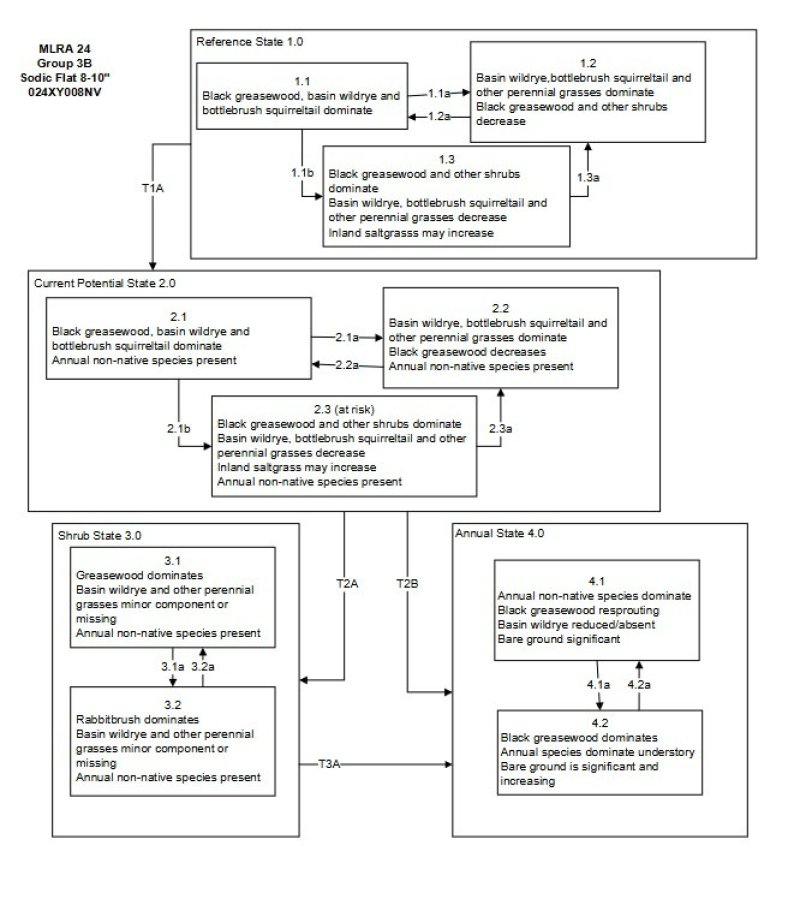
Figure 3. State and Transitional Model
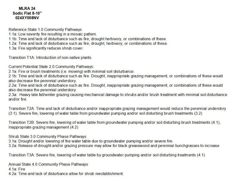
Figure 4. STM Narrative
More interactive model formats are also available.
View Interactive Models
More interactive model formats are also available.
View Interactive Models
Click on state and transition labels to scroll to the respective text
State 1 submodel, plant communities
State 2 submodel, plant communities
State 3 submodel, plant communities
State 4 submodel, plant communities
State 1
Reference State
The Reference State 1.0 is a representative of the natural range of variability under pristine conditions. The reference state has three general community phases; a shrub-grass dominant phase, a perennial grass dominant phase and a shrub dominant phase. State dynamics are maintained by interactions between climatic patterns and disturbance regimes. Negative feedbacks enhance ecosystem resilience and contribute to the stability of the state. These include the presence of all structural and functional groups, low fine fuel loads, and retention of organic matter and nutrients. Plant community phase changes are primarily driven by fire, periodic drought and/or insect or disease attack.
Community 1.1
Reference Plant Community
This community is dominated by black greasewood. Basin wildrye and inland saltgrass are present in the understory. Drought will favor shrubs over perennial bunchgrasses. However, long-term drought will result in an overall decline in the plant community, regardless of functional group.
Figure 5. Annual production by plant type (representative values) or group (midpoint values)
Table 5. Annual production by plant type
| Plant type | Low (lb/acre) |
Representative value (lb/acre) |
High (lb/acre) |
|---|---|---|---|
| Shrub/Vine | 180 | 270 | 420 |
| Grass/Grasslike | 105 | 158 | 245 |
| Forb | 15 | 22 | 35 |
| Total | 300 | 450 | 700 |
Community 1.2
Community Phase 1.2
This community phase is characteristic of a post-disturbance, early-seral community phase. Basin wildrye and alkali sacaton dominate the community. Black greasewood will decrease but will likely sprout and return to pre-burn levels within a few years. Early colonizers such as rabbitbrush and shadscale may increase.
Community 1.3
Community Phase 1.3
Black greasewood and shadscale increase in the absence of disturbance. Decadent shrubs dominate the overstory and deep-rooted perennial bunchgrasses in the understory are reduced either from competition with shrubs, herbivory, drought or combinations of these. Inland saltgrass is more drought tolerant and may increase in the community.
Pathway 1.1a
Community 1.1 to 1.2
A low severity fire would decrease the overstory of black greasewood and allow for the understory perennial grasses to increase. Fires are typically low severity resulting in a mosaic pattern due to low fuel loads. A fire following an unusually wet spring facilitating an increase in fine fuels may be more severe and reduce black greasewood cover to trace amounts.
Pathway 1.1b
Community 1.1 to 1.3
Absence of disturbance over time, significant herbivory, long term drought or combinations of these would allow the black greasewood overstory to increase and dominate the site. This will generally cause a reduction in perennial bunch grasses; however inland saltgrass may increase in the understory depending on the timing and intensity of herbivory. Heavy spring utilization will favor an increase in black greasewood.
Pathway 1.2a
Community 1.2 to 1.1
Time and lack of disturbance will allow black greasewood to increase.
Pathway 1.3a
Community 1.3 to 1.2
Fire will decrease the overstory of black greasewood and allow for the perennial bunchgrasses to dominate the site. Fires are typically high severity in this phase due to the dominance of black greasewood resulting in removal of the overstory shrub community.
State 2
Current Potential State
This state is similar to the Reference State 1.0 with three similar community phases. Ecological function has not changed, however the resiliency of the state has been reduced by the presence of invasive weeds. Non-natives may increase in abundance but will not become dominant within this State. These non-natives can be highly flammable and can promote fire where historically fire had been infrequent. Negative feedbacks enhance ecosystem resilience and contribute to the stability of the state. These feedbacks include the presence of all structural and functional groups, low fine fuel loads, and retention of organic matter and nutrients. Positive feedbacks decrease ecosystem resilience and stability of the state. These include the non-natives’ high seed output, persistent seed bank, rapid growth rate, ability to cross pollinate, and adaptations for seed dispersal.
Community 2.1
Community Phase 2.1
This community phase is compositionally similar to the Reference State Community Phase 1.1 with the presence of non-native species in trace amounts. This community is dominated by black greasewood. Basin wildrye, inland saltgrass, Alkali sacaton, shadscale, rubber rabbitbrush and other shrubs comprise the minor components. Non-native annual species such as halogeton and cheatgrass are present.
Community 2.2
Community Phase 2.2
This community phase is characteristic of a post-disturbance, early-seral community where annual non-native species are present. Perennial bunchgrasses such as alkali sacaton, inland saltgrass and basin wildrye dominate the site. Depending on fire severity patches of intact shrubs may remain. Black greasewood and rabbitbrush may be sprouting. Annual non-native species are stable to increasing in the community.
Community 2.3
Community Phase 2.3 (At Risk)
Black greasewood dominates the overstory and perennial bunchgrasses in the understory are reduced, either from competition with shrubs or from inappropriate grazing, or from both. Rabbitbrush may be a significant component. Inland saltgrass is more grazing tolerant and may increase within the community. Annual non-native species are stable or increasing. This community is at risk of crossing a threshold to State 3.0 (grazing or fire).
Pathway 2.1a
Community 2.1 to 2.2
A low severity fire would decrease the overstory of black greasewood and allow for the understory perennial grasses to increase. Fires are typically low severity resulting in a mosaic pattern due to low fuel loads. A fire following an unusually wet spring or a change in management favoring an increase in fine fuels may be more severe and reduce black sagebrush cover to trace amounts. Brush treatments with minimal soil disturbance may also reduce black greasewood and allow for perennial bunchgrasses to increase. Annual non-native species are likely to increase after fire.
Pathway 2.1b
Community 2.1 to 2.3
Absence of disturbance over time, long term drought, inappropriate grazing management or combinations of these would allow the black greasewood overstory to increase and dominate the site. Inappropriate grazing management reduces the perennial bunchgrass understory; conversely inland saltgrass may increase in the understory.
Pathway 2.2a
Community 2.2 to 2.1
Absence of disturbance over time, long term drought and/or grazing management that favors the establishment and growth of black greasewood allows the shrub component to recover.
Pathway 2.3a
Community 2.3 to 2.2
Grazing management that reduces shrubs will allow for the perennial bunchgrasses in the understory to increase. Heavy late-fall/winter grazing may cause mechanical damage to black greasewood promoting the perennial bunchgrass understory. Brush treatments with minimal soil disturbance will also decrease greasewood and release the perennial understory. Fires may be high severity due to the dominance of black greasewood in this community phase; a fire would decrease the shrub overstory and may allow for an increase in perennial bunchgrasses. Annual non-native species are present and may increase in the community.
State 3
Shrub State
This state has two community phases, one that is characterized by a dominance of black greasewood overstory and the other with a rabbitbrush overstory. This site has crossed a biotic and abiotic threshold and site processes are being controlled by shrubs. Bare ground has increased and pedestalling of grasses may be excessive.
Community 3.1
Community Phase 3.1

Figure 6. T Stringham 4/29/2010 NV777, MU732 Kelk
Figure 7. Sodic Terrace 8-10" Phase 3.1
Figure 8. T. Stringham 4/28/2010, NV777 MU603 Valmy series
Black greasewood dominates the overstory. Rabbitbrush may be a significant component. Deep-rooted perennial bunchgrasses such as basin wildrye have significantly declined. Annual non-native species increase. Bare ground is significant.
Community 3.2
Community Phase 3.2
Rabbitbrush dominates the site. Perennial bunchgrasses are present but a minor component. Annual non-native species are present and may be increasing in the understory.
Pathway 3.1a
Community 3.1 to 3.2
Long term drought and/or lowering of water table by groundwater pumping would reduce black greasewood and allow for rabbitbrush and other shrubs on the site to dominate. Severe fire would also reduce black greasewood overstory and allow for an increase rabbitbrush.
Pathway 3.2a
Community 3.2 to 3.1
Release from long term drought and/or grazing pressure may allow for black greasewood, basin wildrye and other perennial bunchgrasses to increase.
State 4
Annual State
This state has two community phases. In this state, a biotic threshold has been crossed and state dynamics are driven by the dominance and persistence of the annual plant community which is perpetuated by a shortened fire return interval. The herbaceous understory is dominated by annual non-native species such as cheatgrass and halogeton. Bare ground may be abundant. Resiliency has declined and further degradation from fire facilitates a cheatgrass and sprouting shrub plant community. The fire return interval has shortened due to the dominance of cheatgrass in the understory and is a driver in site dynamics.
Community 4.1
Community Phase 4.1
Figure 9. Sodic Terrace 8-10" Phase 4.1
This community is dominated by annual non-native species. Halogeton most commonly invades these sites. Trace amounts of shadscale and other shrubs may be present, but are not contributing to site function. Bare ground may be abundant, especially during low precipitation years. Soil erosion from wind and soil temperature are driving factors in site function.
Community 4.2
Community Phase 4.2
This community is dominated by black greasewood which can sprout after fire. Shadscale is increasing within the community. Annual non-native species dominate the understory.
Pathway 4.1a
Community 4.1 to 4.2
Time and lack of disturbance allows for reestablishment of black greasewood.
Pathway 4.2a
Community 4.2 to 4.1
Fire.
Transition T1A
State 1 to 2
Trigger: Introduction of non-native annual plants. Slow variables: Over time the annual non-native plants will increase within the community. Threshold: Any amount of introduced non-native species causes an immediate decrease in the resilience of the site. Annual non-native species cannot be easily removed from the system and have the potential to significantly alter disturbance regimes from their historic range of variation.
Transition T2A
State 2 to 3
Trigger: To Community Phase 3.1: Inappropriate cattle/horse grazing will decrease or eliminate deep rooted perennial bunchgrasses and favor shrub growth and establishment. To Community Phase 3.2: Severe fire will reduce and/or eliminate black greasewood overstory and decrease perennial bunchgrasses. Soil disturbing brush treatments will reduce black greasewood and possibly increase non-native annual species. Lowering of the water table due to groundwater pumping will also decrease black greasewood and allow for rabbitbrush and other shrubs to increase. Slow variables: Long term decrease in deep-rooted perennial grass density and/or black greasewood. Threshold: Loss of deep-rooted perennial bunchgrasses changes nutrient cycling, nutrient redistribution, and reduces soil organic matter. Loss of long-lived, black greasewood changes the temporal and depending on the replacement shrub, the spatial distribution of nutrient cycling.
Transition T2B
State 2 to 4
Trigger: Fire and/or soil disturbing treatments such as drill seeding and plowing. An unusually wet spring may facilitate the increased germination and production of cheatgrass leading to its dominance within the community. Slow variables: Increased production and cover of non-native annual species. Threshold: Increased, continuous fine fuels modify the fire regime by changing intensity, size and spatial variability of fires. Changes in plant community composition and spatial variability of vegetation due to the loss of perennial bunchgrasses and shadscale truncate energy capture spatially and temporally thus impacting nutrient cycling and distribution.
Transition T3A
State 3 to 4
Trigger: Fire and/or soil disturbing treatments such as drill seeding and plowing. An unusually wet spring may facilitate the increased germination and production of cheatgrass leading to its dominance within the community. Slow variables: Increased production and cover of non-native annual species. Threshold: Increased, continuous fine fuels modify the fire regime by changing intensity, size and spatial variability of fires. Changes in plant community composition and spatial variability of vegetation due to the loss of perennial bunchgrasses and shadscale truncate energy capture spatially and temporally thus impacting nutrient cycling and distribution.
Additional community tables
Table 6. Community 1.1 plant community composition
| Group | Common name | Symbol | Scientific name | Annual production (lb/acre) | Foliar cover (%) | |
|---|---|---|---|---|---|---|
|
Grass/Grasslike
|
||||||
| 1 | Primary Perennial Grasses | 86–261 | ||||
| basin wildrye | LECI4 | Leymus cinereus | 68–180 | – | ||
| squirreltail | ELEL5 | Elymus elymoides | 9–45 | – | ||
| saltgrass | DISP | Distichlis spicata | 9–36 | – | ||
| 2 | Secondary Perennial Grasses | 9–23 | ||||
| western wheatgrass | PASM | Pascopyrum smithii | 2–14 | – | ||
| alkali sacaton | SPAI | Sporobolus airoides | 2–14 | – | ||
|
Forb
|
||||||
| 3 | Perennial Forbs | 9–36 | ||||
| povertyweed | IVAX | Iva axillaris | 2–9 | – | ||
| princesplume | STANL | Stanleya | 2–9 | – | ||
| thelypody | THELY | Thelypodium | 2–9 | – | ||
|
Shrub/Vine
|
||||||
| 4 | Primary Perennial Shrubs | 225–293 | ||||
| greasewood | SAVE4 | Sarcobatus vermiculatus | 225–293 | – | ||
| 5 | Secondary Shrubs | 9–36 | ||||
| rubber rabbitbrush | ERNAN5 | Ericameria nauseosa ssp. nauseosa var. nauseosa | 5–14 | – | ||
| spiny hopsage | GRSP | Grayia spinosa | 5–14 | – | ||
Interpretations
Animal community
Livestock Interpretations:
Traditionally, salt-desert shrub communities provided good winter forage for the expanding sheep and cattle industry in the arid west. Basin wildrye and alkali sacaton will eventually decline with continued abusive grazing. Spring defoliation of basin wildrye and/or consistent, heavy grazing during the growing season may significantly reduce basin wildrye production and density (Krall et al. 1971).
Alkali sacaton may be sensitive to early growing season defoliation whereas late growing season and/or dormant season use allowed recovery of depleted stands (Hickey and Springfield 1966). Less palatable species such as black greasewood, rabbitbrush (Chrysothamnus viscidiflorus and Ericameria nauseosa) and inland saltgrass increase in dominance along with invasive non-native species such as smotherweed, mustards, halogeton, cheatgrass (Roundy 1985) and Russian thistle. Black greasewood is typically not considered an important browse species for wildlife and livestock. However, in a study by Smith et al. (1992), utilization of new growth on greasewood shrubs by cattle was 77 percent in summer, and greasewood was observed to have the highest amounts of crude protein when compared to perennial and annual grasses. Black greasewood plants contain high amounts of sodium and potassium oxalates which are toxic to livestock and caution should be taken when grazing these communities. These shrubs can be used lightly in the spring as long as there is a substantial amount of other preferable forage available (Benson et al. 2011). Black greasewood also provides good cover for wildlife species (Benson et al. 2011).
Stocking rates vary over time depending upon season of use, climate variations, site, and previous and current management goals. A safe starting stocking rate is an estimated stocking rate that is fine tuned by the client by adaptive management through the year and from year to year.
Wildlife Interpretations:
Black greasewood is an important winter browse plant for big game animals and a food source for many other wildlife species. It also receives light to moderate use by mule deer and pronghorn during spring and summer months. Basin wildrye provides winter forage for mule deer, though use is commonly low compared to other native grasses. Basin wildrye provides summer forage for black-tailed jackrabbits. Because basin wildrye remains green throughout early summer, it remains available for small mammal forage for longer time than other grasses.
Bottlebrush squirreltail is a dietary component of several wildlife species. Bottlebrush squirreltail may provide forage for mule deer and pronghorn. Saltgrass provides cover for a variety of bird species, small mammals, and arthropods and is on occasion used as forage for several big game wildlife species.
Hydrological functions
Runoff is low to high. Permeability is slow to moderately slow. Hydrologic soil groups are B, C, and D. Rills are none. Water flow patterns are rare to common. Water flow patterns are typically short, ending in depressional areas. Pedestals are none. "Playette" interspaces between vegetated hummocks have very low infiltration and are ponded for short periods with early spring snow melt (run-in). Tall statured shrubs and associated litter break raindrop impact and provide some opportunity for snow catch and moisture accumulation on the mounds or hummocks that support the majority of vegetation characteristic for this site.
Recreational uses
Aesthetic value is derived from the diverse floral and faunal composition and the colorful flowering of wild flowers and shrubs during the spring and early summer. This site offers rewarding opportunities to photographers and for nature study. This site has potential for upland bird and big game hunting.
Other products
The leaves, seeds and stems of black greasewood are edible. Basin wildrye is used as bedding for various Native American ceremonies, providing a cool place for dancers to stand.
Other information
Black greasewood is useful for stabilizing soil on wind-blown areas. It successfully revegetates eroded areas and sites too saline for most plant species. Basin wildrye is useful in mine reclamation, fire rehabilitation and stabilizing disturbed areas. Its usefulness in range seeding, however, may be limited by initially weak stand establishment. Bottlebrush squirreltail is tolerant of disturbance and is a suitable species for revegetation. Given its extensive system of rhizomes and roots which form a dense sod, saltgrass is considered a suitable species for controlling wind and water erosion.
Supporting information
Inventory data references
NASIS soil component data was used.
Type locality
| Location 1: Elko County, NV | |
|---|---|
| Township/Range/Section | T36N R59E S6 |
| UTM zone | N |
| UTM northing | 4543696 |
| UTM easting | 637795 |
| Latitude | 41° 1′ 58″ |
| Longitude | 115° 21′ 38″ |
| General legal description | NW¼NE¼ Approximately 26 miles east of Elko, along south side of I-80, outer margins of Humboldt River floodplain, Elko County, Nevada. This site also occurs in Eureka, Humboldt, Lander, Pershing, and Washoe Counties, Nevada. |
Other references
Banner, R. E. 1992. Vegetation Types of Utah. Rangelands 14:109-114.
Bentz, B., D. Alston, and T. Evans. 2008. Great Basin Insect Outbreaks. In: Chambers, Jeanne C.; Devoe, Nora; Evenden, Angela, eds. Collaborative management and research in the Great Basin - examining the issues and developing a framework for action. Gen. Tech. Rep. RMRS-GTR-204. Fort Collins, CO: U.S. Department of Agriculture, Forest Service, Rocky Mountain Research Station. p. 45-48
Bich, B.S., J.L. Butler, and C.A. Schmidt. 1995. Effects of differential livestock use of key plant species and rodent populations within selected Oryzopsis hymenoides/Hilaria jamesii communities in Glen Canyon National Recreation Area. The Southwestern Naturalist 40(3):281-287.
Blaisdell, J.P. and R.C. Holmgren. 1984. Managing Intermountain rangelands--salt-desert shrub ranges. Gen. Tech. Rep. INT-163. Ogden, UT: U.S. Department of Agriculture, Forest Service, Intermountain Forest and Range Experiment Station. 52 p.
Blauer, A.C., A.P. Plummer, E.D. McArthur, R. Stevens, and B.C. Guinta. 1976. Characteristics and hybridization of important Intermountain shrubs. II. Chenopod family. Res. Pap. INT-177. Ogden, UT: U.S. Department of Agriculture, Forest Service, Intermountain Forest and Range Experiment Station. 49 p.
Booth, D. T., C. G. Howard, and C. E. Mowry. 2006. 'Nezpar'Indian ricegrass: description, justification for release, and recommendations for use. Rangelands Archives 2:53-54.
Branson, F.A., R.F. Miller, and I.S. McQueen. 1976. Moisture relationships in twelve northern desert shrub communities near Grand Junction, Colorado. Ecology 57(6):1104-1124.
Britton, C.M., G.R. McPherson, and F.A. Sneva. 1990. Effects of burning and clipping on five bunchgrasses in eastern Oregon. The Great Basin Naturalist 50(2):115-120.
Brown, R.W., Jr. 1965. The distribution of plant communities in the badlands of southeastern Montana. Bozeman, MT: Montana State University. 145 p. Thesis.
Caudle, D., J. DiBenedetto, M. Karl, H. Sanchez, and C. Talbot. 2013. Interagency ecological site handbook for rangelands. Available at: http://jornada.nmsu.edu/sites/jornada.nmsu.edu/files/InteragencyEcolSiteHandbook.pdf. Accessed 4 October 2013.
Chambers, J. C. and B. E. Norton. 1993. Effects of grazing and drought on population dynamics of salt desert species on the Desert Experimental Range, Utah. Journal of Arid Environments 58:261-275.
Chambers, J., B. Bradley, C. Brown, C. D’Antonio, M. Germino, J. Grace, S. Hardegree, R. Miller, and D. Pyke. 2013. Resilience to stress and disturbance, and resistance to bromus tectorum L. Invasion in Cold Desert Shrublands of Western North America. Ecosystems:1-16.
Cibils, A. F., S. M. David, and D. E. McArthur. 1998. Plant-herbivore interactions in Atriplex: current state of knowledge. General Technical Report RMRS-GTR-14, USDA: FS, Rocky Mountain Research Station, Ogden, UT.
Cook, C. W. 1962. An evaluation of some common factors affecting utilization of desert range species. Journal of Range Management 15:333-338.
Cook, C.W. and R.D. Child. 1971. Recovery of desert plants in various states of vigor. Journal of Range Management 24(5):339-343.
Dobrowolski, J.P., Caldwell, M.M. and Richards, J.H. 1990. Basin hydrology and plant root systems. In: Plant Biology of the Basin and Range. Springer-Verlag Pub., New York, NY.- In library
Eckert, R.E., Jr., A.D. Bruner, and G.J. Klomp. 1973. Productivity of tall wheatgrass and great basin wildrye under irrigation on a greasewood – rabbitbrush range site. Journal of Range Management 26(4):286-288.
Eckert, R.E., Jr., F.F. Peterson, and F.L. Emmerich. 1987. A study of factors influencing secondary succession in the sagebrush [Artemisia spp. L.] type. In: Frasier, G.W. and R.A. Evans, (eds.). Proceedings of the symposium: "Seed and seedbed ecology of rangeland plants"; 1987 April 21-23; Tucson, AZ. Washington, DC: U.S. Department of Agriculture, Agricultural Research Service: Pgs 149-168.
Eddleman, L.E. 2002. Sarcobatus vermiculatus (Hook.) Torr.: Black greasewood. In: Bonner, F.T. (tech. coord.). Woody plant seed manual, [Online]. Washington, DC: U.S. Department of Agriculture, Forest Service (Producer).
Fernandez, O.A. and M.M. Caldwell. 1975. Phenology and dynamics of root growth of three cool semi-desert shrubs under field conditons. J. of Ecology 63(2):703-714.
Ganskopp, D.C. 1986. Tolerances of sagebrush, rabbitbrush, and greasewood to elevated water tables. Journal of Range Management 39(4):334-337.
Groeneveld, D.P. and D.E. Crowley. 1988. Root system response to flooding in three desert shrub species. Functional Ecology 2:491-497.
Groeneveld, D.P. 1990. Shrub rooting and water acquisition on threatened shallow groundwater habitats in the Owens Valley, California. In: McArthur, E.D. E.M. Romney, S.D. Smith, and P.T. Tueller (compilers). Proceedings--symposium on cheatgrass invasion, shrub die-off, and other aspects of shrub biology and management; 1989 April 5-7; Las Vegas, NV. Gen. Tech. Rep. INT-276. Ogden, UT: U.S. Department of Agriculture, Forest Service, Intermountain Research Station: Pgs 221-237.
Harr, R.D. and K.R. Price. 1972. Evapotranspiration from a greasewood-cheatgrass community. Water Resources Research 8(5):1199-1203.
Hickey, Jr., W.C. and H.W. Springfield. 1966. Alkali sacaton: its merits for forage and cover. Journal of Range Management 19(2):71-74.
Hironaka, M. and E.W. Tisdale. 1972. Growth and development of Sitanion hystrix and Poa sandbergii. Research Memorandum RM 72-24. U.S. International Biological Program, Desert Biome. 15 p.
Holmgren, R.C. and S.S. Hutchings. 1972. Salt desert shrub response to grazing use. In: McKell, C.M., J.P. Blaisdell, and J.R. Goodin, (eds.). Wildland shrubs--their biology and utilization: Proceedings of a symposium; 1971 July; Logan, UT. Gen. Tech. Rep. INT-1. Ogden, UT: U.S. Department of Agriculture, Forest Service, Intermountain Forest and Range Experiment Station: Pgs 153-164.
Hutchings, S.S. and G. Stewart. 1953. Increasing forage yields and sheep production on Intermountain winter ranges. Circular No. 925. Washington, DC: U.S. Department of Agriculture. 63 p.
Knapp, P.A. 1998. Spatio-temporal patterns of large grassland fires in the Intermountain West, U.S.A. Global Ecology and Biogeography Letters 7(4):259-273.
Krall, J.L., J.R. Stroh, C.S. Cooper, and S.R. Chapman. 1971. Effect of time and extent of harvesting on basin wildrye. Journal of Range Management 24:414-418.
Lei, S.A. 1999. Effects of severe drought on biodiversity and productivity in a cresote bush-blackbrush ecotone of southern Nevada. In: McArthur, E.D., W.K. Ostler, and C.L. Wambolt (compilers). Proceedings: shrubland ecotones; 1998 August 12-14; Ephraim, UT.
Proceedings RMRS-P-11. Ogden, UT: U.S. Department of Agriculture, Forest Service, Rocky Mountain Research Station: Pgs 217-221.
Marcum, K.B. and D.H. Kopec. 1997. Salinity tolerance of turfgrasses and alternative species in the subfamily Chloridoideae (Poaceae). International Turfgrass Society Research Journal 8:735-742.
Mozingo, H.N. 1987. Shrubs of the Great Basin: A natural history. Reno, NV: University of Nevada Press. 342 p.
Nelson, C.R., B.A. Haws and D.L. Nelson. 1990. Mealybugs and related homoptera of shadscale: Possible agents in the dieoff problem in the intermountain west. Pages 152-165 in Proceedings-Symposium on Cheatgrass Invasion, Shrub Die-off, and Other Aspects of Shrub Biology andManagement. Gen. Tech. Rep. INT-GRT-276. USDA, Forest Service, Intermountain Research Station, Ogden, UT.
Paysen, T.E., R.J. Ansley, J.K. Brown, G.J. Gotffried, S.M. Haase, M.G. Harrington, M.G. Narog, S.S. Sackett, and R.C. Wilson. 2000. Fire in western shrubland, woodland, and grassland ecosystems. In: Brown, J.K. and J.K. Smith (eds.). Wildland fire in ecosystems: Effects of fire on flora. Gen. Tech. Rep. RMRS-GTR-42-volume 2. Ogden, UT: U.S. Department of Agriculture, Forest Service, Rocky Mountain Research Station: Pgs 121-159.
Pearson, L.C. 1964. Effect of harvest date on recovery of range grasses and shrubs. Agronomy Journal 56:80-82.
Pearson, L.C. 1965. Primary Production in Grazed and Ungrazed Desert Communities of Eastern Idaho. Ecology 46:278-285.
Pearson, L.C. 1976. Primary production in grazed and ungrazed desert communities of eastern Idaho. Ecology 46(3):278-285.
Peters, E. F. and S. C. Bunting. 1994. Fire conditions pre- and post-occurrence of annual grasses on the Snake River Plain. In: Monsen, S.B. and S.G. Kitchen (compilers). Proceedings--ecology and management of annual rangelands; 1992 May 18-22; Boise, ID. Gen. Tech. Rep. INT-GTR-313. Ogden, UT: U.S. Department of Agriculture, Forest Service, Intermountain Research Station: 31-36.
Robertson, J.H. 1983. Greasewood (Sarcobatus vermiculatus (Hook.) Torr.). Phytologia. 54(5):309-324.
Romo, J.T. 1985. Water relations in Artemisia tridentata subsp. wyomingensis, Sarcobatus vermiculatus, and Kochia prostrata. Ph.D. Thesis. Oregon State University, Corvallis, OR.
Roundy, B.A. 1985. Emergence and establishment of basin wildrye and tall wheatgrass in relation to moisture and salinity. Journal of Range Management 38(2):126-131.
Sanderson, S.C. and H.C. Stutz. 1994. Woody chenopods useful for rangeland reclamation in western North America. In: Monsen, S.B. and S.G. Kitchen (compilers). Proceedings--ecology and management of annual rangelands; 1992 May 18-22; Boise, ID. Gen. Tech. Rep. INT-GTR-313. Ogden, UT: U.S. Department of Agriculture, Forest Service, Intermountain Research Station: Pgs 374-378.
Schultz, B.W. and W.K. Ostler. 1995. Effects of prolonged drought on vegetation associations in the northern Mojave Desert. In: Roundy, B.A., E.D. McArthur, J.S. Haley, and D.K. Mann (compilers). Proceedings: wildland shrub and arid land restoration symposium; 1993 October 19-21; Las Vegas, NV. Gen. Tech. Rep. INT-GTR-315. Ogden, UT: U.S. Department of Agriculture, Forest Service, Intermountain Research Station: Pgs 228-235.
Sheeter, G.R. 1968. Secondary succession and range improvements after wildfire in northeastern Nevada. Reno, NV: University of Nevada. 203 p. Thesis.
Smith, S. D. and P. S. Nobel. 1986. Deserts. Pages 13-62 in Photosynthesis in contrasting environments. Elsevier Science Publishers, Amsterdam, The Netherlands.
Stuart, D.M., G.E. Schuman, and A.S. Dylla. 1971. Chemical characteristics of the coppice dune soils in Paradise Valley, Nevada. Proceedings of the Soil Science Society of America 34:607-611.
Stubbendieck, J., J.T. Nichols, and K.K. Roberts. 1985. Nebraska range and pasture grasses (including grass-like plants). E.C. 85-170. Lincoln, NE: University of Nebraska, Department of Agriculture, Cooperative Extension Service. 75 p.
Vallentine, John F. 1989. Range Development and Improvements. Third Ed. Academic Press, Inc. San Diego, CA. p. 524.
Vest, E.D. 1962. Biotic communities in the Great Salt Lake desert. Ecology and Epizoology Series No. 73. Salt Lake City, UT: University of Utah, Division of Biological Sciences, Institute of Environmental Biological Research. 122 p.
West, N.E. 1994. Effects of fire on salt-desert shrub rangelands. In: Monsen, S.B. and S.G. Kitchen (compilers). Proceedings--ecology and management of annual rangelands; 1992 May 18-22; Boise, ID. Gen. Tech. Rep. INT-GTR-313. Ogden, UT: U.S. Department of Agriculture, Forest Service, Intermountain Research Station: Pgs 71-74.
Wright, H. A. 1971. Why Squirreltail Is More Tolerant to Burning than Needle-and-Thread. Journal of Range Management 24:277-284.
Wright, H. A. 1985. Effects of fire on grasses and forbs in sagebrush-grass communities. Pages 12-21 in Rangeland Fire Effects; A Symposium: Boise, ID, USDI-BLM.
Young, J.A. and R.A. Evans 1977. Squirreltail seed germination. Journal of Range Management 30(1):33-36.
Young, J.A., R.A. Evans, and P.T. Tueller. 1975. Great Basin plant communities – pristine and grazed. In: R. Elston (ed.) Holocene climate in the Great Basin, Occasional Papers, Nevada Archeological Survey, Reno NV. Pgs 187-212.
Young, J. A. and F. Tipton. 1990. Invasion of cheatgrass into arid environments of the Lahontan Basin. Pages 37-40 in Proceedings- Symposium on cheatgrass invasion, shrub die-off, and other aspects of shrub biology and management. Gen. Tech. Rep. INT-276. USDA, Forest Service, Intermountain Research Station, Las Vegas, NV.
Young, R.P. 1983. Fire as a vegetation management tool in rangelands of the Intermountain region. In: Monsen, S.B. and N. Shaw (compilers). Managing Intermountain rangelands--improvement of range and wildlife habitats: Proceedings of symposia; 1981 September 15-17; Twin Falls, ID; 1982 June 22-24; Elko, NV. Gen. Tech. Rep. INT-157. Ogden, UT: U.S. Department of Agriculture, Forest Service, Intermountain Forest and Range Experiment Station: Pgs 18-31.
Zielinski, M.J. 1994. Controlling erosion on lands administered by the Bureau of Land Management, Winnemucca District, Nevada. In: Monsen, Stephen B. and S.G. Kitchen (compilers). Proceedings-ecology and management of annual rangelands; 1992 May 18-22; Boise, ID. Gen. Tech. Rep. INT-GTR-313. Ogden, UT: U.S. Department of Agriculture, Forest Service, Intermountain Research Station: Pgs 143-146.
Zschaechner, G.A. 1985. Studying rangeland fire effects: a case study in Nevada. In: Sanders, K. and J. Durham (eds). Rangeland fire effects. Proceedings of the symposium. 1984 November 27-29; Boise, ID. Boise, ID. U.S. Department of the Interior, Bureau of Land Management, Idaho State Office. Pgs 66-84.
Contributors
CP/GKB
TK Stringham
P NovakEchenique
Approval
Kendra Moseley, 3/07/2025
Rangeland health reference sheet
Interpreting Indicators of Rangeland Health is a qualitative assessment protocol used to determine ecosystem condition based on benchmark characteristics described in the Reference Sheet. A suite of 17 (or more) indicators are typically considered in an assessment. The ecological site(s) representative of an assessment location must be known prior to applying the protocol and must be verified based on soils and climate. Current plant community cannot be used to identify the ecological site.
| Author(s)/participant(s) | Patti Novak-Echenique |
|---|---|
| Contact for lead author | State Rangeland Management Specialist |
| Date | 12/17/2009 |
| Approved by | Kendra Moseley |
| Approval date | |
| Composition (Indicators 10 and 12) based on | Annual Production |
Indicators
-
Number and extent of rills:
Rills are none. -
Presence of water flow patterns:
Water flow patterns are rare to common. Water flow patterns are typically short, ending in depressional areas. -
Number and height of erosional pedestals or terracettes:
Pedestals are none. -
Bare ground from Ecological Site Description or other studies (rock, litter, lichen, moss, plant canopy are not bare ground):
Bare Ground ± 75 percent. -
Number of gullies and erosion associated with gullies:
Gullies are none. -
Extent of wind scoured, blowouts and/or depositional areas:
None -
Amount of litter movement (describe size and distance expected to travel):
Fine litter (foliage of grasses and annual & perennial forbs) only expected to move during periods of ponding or flooding. Persistent litter (large woody material) will remain in place except during major ponding or flooding events. -
Soil surface (top few mm) resistance to erosion (stability values are averages - most sites will show a range of values):
Soil stability values range from 4 to 6 under canopy and 2 to 4 in the interspaces. -
Soil surface structure and SOM content (include type of structure and A-horizon color and thickness):
Structure of soil surface is thin to medium platy or granular. Soil surface colors are light grays or pale browns and are typified by an ochric epipedon. Organic matter can range from about 1 percent to 2.5 percent. -
Effect of community phase composition (relative proportion of different functional groups) and spatial distribution on infiltration and runoff:
"Playette" interspaces between vegetated hummocks have very low infiltration and are ponded for short periods with early spring snowmelt (run-in). Tall statured shrubs and associated litter break raindrop impact and provide some opportunity for snow catch and moisture accumulation on the mounds or hummocks that support the majority of vegetation characteristic for this site. -
Presence and thickness of compaction layer (usually none; describe soil profile features which may be mistaken for compaction on this site):
Compacted layers are not typical. Platy, subangular blocky, prismatic, or massive subsurface layers are normal for this site and are not to be interpreted as compaction. -
Functional/Structural Groups (list in order of descending dominance by above-ground annual-production or live foliar cover using symbols: >>, >, = to indicate much greater than, greater than, and equal to):
Dominant:
Salt-desert phreatophytic shrubs (Black greasewood)Sub-dominant:
tall-statured, deep-rooted, cool season, perennial bunchgrasses > short-statured rhizomatous
grasses > associated perennial grasses and grass-like plants = deep-rooted, cool season, perennial forbs = fibrous, shallow-rooted, cool
season, perennial and annual forbsOther:
Microbiotic crustsAdditional:
-
Amount of plant mortality and decadence (include which functional groups are expected to show mortality or decadence):
Dead branches within individual shrubs common and standing dead shrub canopy material may be as much as 25 percent of total woody canopy. -
Average percent litter cover (%) and depth ( in):
Within plant interspaces 10-25% and depth of litter ± ¼ inch. -
Expected annual annual-production (this is TOTAL above-ground annual-production, not just forage annual-production):
For normal or average growing season (through end of May) ±450 lbs/ac; Winter moisture significantly affects total production. Favorable years ±700 lbs/ac and unfavorable years ±300 lbs/ac. -
Potential invasive (including noxious) species (native and non-native). List species which BOTH characterize degraded states and have the potential to become a dominant or co-dominant species on the ecological site if their future establishment and growth is not actively controlled by management interventions. Species that become dominant for only one to several years (e.g., short-term response to drought or wildfire) are not invasive plants. Note that unlike other indicators, we are describing what is NOT expected in the reference state for the ecological site:
Potential invaders include annual mustards, bur buttercup, smotherweed, halogeton, and cheatgrass. -
Perennial plant reproductive capability:
All functional groups should reproduce in average (or normal) and above average growing season years. Reduced growth and reproduction occur during extreme or extended drought periods.
Print Options
Sections
Font
Other
The Ecosystem Dynamics Interpretive Tool is an information system framework developed by the USDA-ARS Jornada Experimental Range, USDA Natural Resources Conservation Service, and New Mexico State University.
Click on box and path labels to scroll to the respective text.