Provisional. A provisional ecological site description has undergone quality control and quality assurance review. It contains a working state and transition model and enough information to identify the ecological site.
MLRA notes
Major Land Resource Area (MLRA): 024X–Humboldt Basin and Range Area
Major land resource area (MLRA) 24, the Humboldt Area, covers an area of approximately 8,115,200 acres (12,680 sq. mi.). MLRA 24 is in the Great Basin Section of the Basin and Range Province of the Intermontane Plateaus. Elevations predominantly range from 3,950 to 5,900 feet (1,205 to 1,800 meters). The elevations of some mountain peaks are more than 8,850 feet (2,700 meters).
A series of widely spaced north-south trending mountain ranges are separated by broad valleys filled with alluvium washed in from adjacent mountain ranges. Most valleys are drained by tributaries to the Humboldt River. Playas, however, occur in lower elevation valleys with closed drainage systems. Isolated ranges are dissected, uplifted fault-block mountains.
Geology is comprised of Mesozoic and Paleozoic volcanic rock and marine and continental sediments. Young andesite and basalt flows (6 to 17 million years old) are at the margins of the mountains.
Dominant soil orders include Aridisols, Entisols, Inceptisols and Mollisols. Soils of the area are generally characterized by a mesic soil temperature regime, an aridic soil moisture regime and mixed geology. They are generally well drained, loamy and very deep.
75 percent of MLRA 24 is federally owned. The remainder is primarily used for farming, ranching and mining. Irrigated land comprises 3 percent of the area; most of the irrigation water is from surface water sources, such as the Humboldt River and Rye Patch Reservoir.
Annual precipitation typically ranges from 6 to 12 inches (15 to 30 cm) for most of the area. In the mountains however the precipitation may be up to 40 inches (101 cm). Most of the annual precipitation is from snow in the winter. In the spring and fall, rainfall occurs as high- intensity, convective thunderstorms.
Nevada is on the eastern, lee side of the Sierra Nevada Range; a massive mountain barrier that markedly influences the climate of the State. The prevailing winds are from the west. The warm moist air from the Pacific Ocean ascends the western slopes of the Sierra Range, the air cools, condenses and the moisture falls as precipitation. As the air descends the eastern slope, it is warmed by compression, and very little precipitation occurs. The effects of this mountain barrier are felt not only in the west but throughout the State. The result is the lowlands of Nevada are largely desert or steppes.
Ecological site concept
Saline Bottom ecological site is on alluvial flats, stream terraces and flood plains. Soils are very deep, somewhat poorly drained and formed in alluvium derived from mixed alluvium, loess and volcanic ash. The soil profile is characterized by an ochric epipedon, strong to moderate salinity throughout and a high water table between 70-100cm at some time during the year. Sodicity (SAR) is 13-99 in the upper 50cm and decreases with depth. The soil temperature regime is mesic and an aridic moisture regime exists during the growing season in normal years after ground water levels drop below the moisture control section.
Important abiotic factors contributing to this ecological site include sodicity, high amounts of soluble salts in the profile, increased available soil moisture to landscape position and seasonally available ground water.
This ecological site is on alluvial flats. Soils are deep, poorly to somewhat poorly drained, and formed in alluvium derived from mixed rocks with a component of volcanic ash.
Soils are very deep, well drained and formed in a thin layer of loess and alluvium derived from mixed parent material influenced by volcanic ash over lacustrine sediments and characterized by a very low infiltration.
This ecological site is on stream terraces and on fan skirts along intermittent drainageways. Soils are very deep, moderately well drained and formed in alluvium derived from mixed rocks with components of loess and volcanic ash.
This ecological occurs on floodplains and inset fans. Soils are very deep, poorly drained and formed in alluvium derived from mixed parent material. The soil profile is characterized by a fine sand surface texture.
This ecological site is on alluvial flats, stream terraces and flood plains. Soils are very deep, somewhat poorly drained and formed in alluvium derived from mixed alluvium, loess and volcanic ash.
This ecological site is on alluvial flats, stream terraces and flood plains. Slopes range from 0 to 4 percent but are typically less than 2 percent. Elevations are from 3900 to 6000 (1189 to 1829 meters) feet.
The climate is semiarid, characterized by cold, moist winters, and warm, somewhat dry summers. Average annual precipitation is 6 to 10 inches (15 to 25 cm). Mean annual air temperature is 45 to 53 degrees F. The average growing season is about 90 to 130 days.
Table 3. Representative climatic features
Frost-free period (characteristic range)
75-77 days
Freeze-free period (characteristic range)
103-107 days
Precipitation total (characteristic range)
9-10 in
Frost-free period (actual range)
75-77 days
Freeze-free period (actual range)
102-108 days
Precipitation total (actual range)
8-10 in
Frost-free period (average)
76 days
Freeze-free period (average)
105 days
Precipitation total (average)
9 in
Characteristic range
Actual range
Bar
Line
Figure 1. Monthly precipitation range
Characteristic range
Actual range
Bar
Line
Figure 2. Monthly minimum temperature range
Characteristic range
Actual range
Bar
Line
Figure 3. Monthly maximum temperature range
Bar
Line
Figure 4. Monthly average minimum and maximum temperature
Figure 5. Annual precipitation pattern
Figure 6. Annual average temperature pattern
Climate stations used
(1) WINNEMUCCA MUNI AP [USW00024128], Winnemucca, NV
(2) OROVADA 3 W [USC00265818], Orovada, NV
Influencing water features
This site is associated with perennial streams and dry lake beds.
Soil features
The soils associated with this site are very deep, somewhat poorly drained and formed in alluvium derived from mixed parent material with loess and volcanic ash.
These soils are characterized by ochric epipedon and are strongly salt and sodium affected in their upper profile with SAR ranging from 13-99. Salt and sodium concentrations typically decrease with depth.
A seasonal high water table exists at depths of 20 to 60 inches (51 to 152 cm). Additional moisture is received on this site during the winter and spring months as run-in from higher landscapes or occasional brief overflow from adjacent streams. Wetting of these soils dilutes their salt and sodium concentrations and the degree of salinity and alkalinity fluctuates widely through the year. Permeability is slow to moderately slow. Seed viability, germination, and available water capacity is reduced due to the saline condition of these soils. The surface layer of these soils will crust and bake upon drying, inhibiting water infiltration and seedling emergence.
A representative soil series associated with this ecological site is Wendane, a fine-silty, mixed, superactive, calcareous, mesic Aquandic Halaquepts.
Soil series associated with this site includes: Argenta, Bloor, Cluro, Delvada, Dunphy, Humbolt, Hussa, Ocala, paranat, Rixie, Rose Creek, Sonoma, Umberland, Wendane, and Yobe.
Table 4. Representative soil features
Parent material
(1) Alluvium (2) Loess (3) Volcanic ash
Surface texture
(1) Silt loam
(2) Very fine sandy loam
(3) Silty clay loam
Family particle size
(1) Loamy
Drainage class
Somewhat poorly drained to poorly drained
Permeability class
Slow to moderately slow
Soil depth
72–84 in
Surface fragment cover <=3"
4%
Surface fragment cover >3"
2%
Available water capacity (0-40in)
6–8.3 in
Calcium carbonate equivalent (0-40in)
5–15%
Electrical conductivity (0-40in)
15–50 mmhos/cm
Sodium adsorption ratio (0-40in)
1–99
Soil reaction (1:1 water) (0-40in)
7.4–11
Subsurface fragment volume <=3" (Depth not specified)
5%
Subsurface fragment volume >3" (Depth not specified)
2%
Ecological dynamics
An ecological site is the product of all the environmental factors responsible for its development and it has a set of key characteristics that influence a site’s resilience to disturbance and resistance to invasives. Key characteristics include 1) climate (precipitation, temperature), 2) topography (aspect, slope, elevation, and landform), 3) hydrology (infiltration, runoff), 4) soils (depth, texture, structure, organic matter), 5) plant communities (functional groups, productivity), and 6) natural disturbance regime (fire, herbivory, etc.) (Caudle et al 2013). Biotic factors that influence resilience include site productivity, species composition and structure, and population regulation and regeneration (Chambers et al. 2013).
The Great Basin shrub communities have high spatial and temporal variability in precipitation, both among years and within growing seasons. Nutrient availability is typically low but increases with elevation and closely follows moisture availability. The moisture resource supporting
the greatest amount of plant growth is typically the water stored in the soil profile during the winter. The invasibility of plant communities is commonly linked to resource availability. Disturbance can decrease resource uptake due to damage or mortality of the native species and depressed competition or can increase resource pools by the decomposition of dead plant material following disturbance.
Black greasewood is classified as a phreatophyte (Eddleman 2002), and its distribution is well correlated with the distribution of groundwater (Mozingo 1987). Meinzer (1927) discovered that the taproots of black greasewood could penetrate from 20 to 57 feet (6 to 17 meters) below the surface.
Romo (1984) observed water tables ranging from 3.5 to 15 m under black greasewood dominated communities in Oregon. Black greasewood stands develop best where moisture is readily available, either from surface or subsurface runoff (Brown 1971). It is commonly on floodplains that are either subject to periodic flooding, have a high water table at least part of the year, or have a water table less than 34 feet (10 meters) deep (Harr and Price 1972, Blauer et al. 1976, Branson et al. 1976, Blaisdell and Holmgren 1984, Eddleman 2002). Ganskopp (1986) reported that water tables within 9.8 to 11.8 inches (25 to 30 cm) (of the surface had no effect on black greasewood in Oregon. However, a study, conducted in California, observed black greasewood to not survive six months of continuous flooding (Groeneveld and Crowley 1988, Groeneveld 1990). Black greasewood is typically a deep-rooted shrub but has some shallow roots near the soil surface; the maximum rooting depth can be determined by the depth to a saturated zone (Harr and Price 1972). The perennial bunchgrasses generally have somewhat shallower root systems than the shrubs, but root densities are commonly as high as or higher than those of shrubs in the upper 0.5 m but taper off more rapidly than shrubs. However, basin wildrye is weakly rhizomatous and has root depths of up to 2 meters. Basin wildrye exhibits greater lateral root spread than many other grass species (Abbott et al. 1991, Reynolds and Fraley 1989).
Drought will initially cause a decline in bunchgrasses, but prolonged drought will eventually cause a decline in shrubs, including black greasewood. As site condition deteriorates, these sites may become a pure stand of black greasewood or a pure stand with an annual understory. Marcum and Kopec (1997) observed inland saltgrass more tolerant of increased levels of salinity than alkali sacaton therefore dewatering and/or long term drought causing increased levels of salinity would create environmental conditions more favorable to inland saltgrass over alkali sacaton. Alkali sacaton is considered a facultative wet species in this region; therefore it is not drought tolerant. A lowering of the water table can occur with ground water pumping in these sites. This may contribute to the loss of deep-rooted species such as greasewood and basin wildrye and an increase in rabbitbrush, shadscale and other species with the absence of drought.
Basin wildrye is a large, cool-season perennial bunchgrass with an extensive deep coarse fibrous root system (Reynolds and Fraley 1989). Clumps may reach up to six feet (1.8 meters) in height (Ogle et al 2012b). Basin wildrye does not tolerate long periods of inundation; it prefers cycles of wet winters and dry summers and is most commonly in deep soils with high water holding capacities or seasonally high water tables (Ogle et al 2012b, Perryman and Skinner 2007).
Seasonally high water tables are necessary for maintenance of site productivity and reestablishment of basin wildrye stands following disturbances such as fire, drought or excessive herbivory (Eckert et al. 1973). The sensitivity of basin wildrye seedling establishment to reduced soil water availability is increased as soil pH increases (Stuart et al. 1971). Lowering of the water table through extended drought, channel incision or water pumping will decrease basin wildrye production and establishment, while sagebrush, black greasewood, rabbitbrush, and invasive weeds increase. Farming and abandonment may facilitate the creation of surface vesicular crust, increased surface ponding, and decreased infiltration; which leads to dominance by sprouting shrubs and an annual understory.
This ecological site has moderate resilience to disturbance and resistance to invasion. Primary disturbances on these ecological sites is drought, fire, flooding, Aroga infestation (Aroga websteri), and channel incision or other disturbance leading to a lowered seasonal water table. This facilitates an increase in shrubs and a decrease in basin wildrye. The introduction of annual weedy species, like cheatgrass (Bromus tectorum), may cause an increase in fire frequency and eventually lead to an annual state or a state dominated by rabbitbrush. Other troublesome non-native weeds such as broadleaved pepperweed or tall whitetop (Lepidium latifolium), hoary cress or whitetop (Cardaria draba), scotch cottonthistle (Onopordum acanthium) or bull thistle (Cirsium vulgare) are potential invaders on this site. Two possible alternative stable states have been identified for this site.
Fire Ecology:
Natural fire return intervals are estimated to vary between less than 35 years up to 100 years in salt desert ecosystems with basin wildrye (Paysen et al. 2000). Higher production sites would have experienced fire more frequently than lower production sites. Basin wildrye is relatively resistant to fire, particularly dormant season fire, as plants sprout from surviving root crowns and rhizomes (Zschaechner 1985). Fire maintained the grass dominance of these ecosystems. Increases in the fire return interval leads to increases in the shrub component of the plant community, potentially facilitating increases in bare ground, inland saltgrass and invasive weeds. Lack of fire combined with excessive herbivory converts these sites to black greasewood dominance.
Basin wildrye is relatively resistant to fire, particularly dormant season fire, as plants sprout from surviving root crowns and rhizomes (Zschaechner 1985). Fire maintained the grass dominance of these ecosystems, therefore increases in the fire return interval favors increases in the shrub component of the plant community. The reduction of grasses potentially facilitates increases in bare ground, inland salt grass, and invasive weeds. Lack of fire combined with excessive herbivory converts these sites to sagebrush, black greasewood, and rabbitbrush dominance.
Historically, black greasewood-saltbush communities had sparse understories and bare soil in intershrub spaces, making these communities somewhat resistant to fire (Young 1983, Paysen et al. 2000). They may burn only during high fire hazard conditions; for example, years with high precipitation can result in almost continuous fine fuels, increasing fire hazard (West 1994, Paysen et al. 2000). Black greasewood may be killed by severe fires, but can resprout after low to moderate severity fires (Robertson 1983, West 1994). Bentz et al. (2008) reported that
following a Nevada wildfire, black greasewood sprouts reached approximately 2.5 feet (76 cm) within 3 years. Grazing and other disturbance may result in increased biomass production due to sprouting and increased seed production, also leading to greater fuel loads (Sanderson and Stutz 1994, Paysen et al. 2000).
During settlement, many of the cattle in the Great Basin were wintered on extensive basin wildrye stands, however due to sensitivity to spring use many stands were decimated by early in the 20th century (Young et al. 1975). Less palatable species such as black greasewood, rabbitbrush and inland saltgrass increased in dominance along with invasive non-native species such as fivehook bassia, mustards, halogeton and cheatgrass (Roundy 1985). Spring defoliation of basin wildrye and/or consistent, heavy grazing during the growing season may significantly reduce basin wildrye production and density (Krall et al. 1971). Thus, inadequate rest and recovery from defoliation can cause a decrease in basin wildrye and an increase in rabbitbrush and black greasewood, along with inland saltgrass and non-native weeds (Young et al. 1975, Roundy 1985). Additionally, natural basin wildrye seed viability may be low and seedlings lack vigor (Young and Evans 1981). Roundy (1985) observed that although basin wildrye is adapted to seasonally dry saline soils, high and frequent spring precipitation is necessary to establish it from seed suggesting that establishment of natural basin wildrye seedlings happens only during years of unusually high precipitation. Therefore, reestablishment of a stand that has been decimated by grazing may be episodic.
Hydrology of these basin wildrye dominated sites is also critical for site function and maintenance. Seasonally high water tables have been o necessary for maintenance of site productivity and reestablishment of basin wildrye stands following disturbances such as fire, drought or excessive herbivory (Eckert et al. 1973). The sensitivity of basin wildrye seedling establishment to reduced soil water availability is increased as soil pH increases (Stuart et al. 1971). Lowering of the water table through extended drought or water pumping will decrease basin wildrye production and establishment while black greasewood, rabbitbrush, inland saltgrass and invasive weeds increase. Farming of saline-sodic soils may cause an increase in soil pH in the surface horizons leading to soil surface sealing, increased ponding and reduced infiltration. Additionally farming may facilitate the creation of a cemented layer (plow pan) causing a reduction in root penetration of seedlings. Cessation of farming leads to rabbitbrush dominance, increased bare ground and the potential for weed invasion.
As ecological condition declines and where management results in abusive grazing use by livestock, rabbitbrush and black greasewood increase and become the dominant vegetation in lower condition classes. Inland saltgrass increases as condition declines and typically dominates the understory when this site is in low ecological condition. Fivehook bassia and annual mustards are species likely to invade this site.
Fire Ecology:
Black greasewood communities have been historically subject to stand-replacing fire regimes with intervals of <100 years. Basin wildrye is top-killed by fire. Older basin wildrye plants with large proportions of dead material within the perennial crown can be expected to show higher mortality due to fire than younger plants having little debris. Fire maintained the grass dominance of these ecosystems. Increases in the fire return interval leads to increases in the shrub component of the plant community, potentially facilitating increases in bare ground, inland saltgrass and invasive weeds. Lack of fire combined with excessive herbivory converts these sites to black greasewood dominance. Basin wildrye is generally tolerant of fire but may be damaged by early season fire combined with dry soil conditions. Alkali sacaton is classified as tolerant of, but not resistant to, fire. Top-killing by fire is probably frequent, and the plants can be killed by severe fire. Saltgrass rhizomes occur deep in the soil where they are insulated from the heat of most fires. Saltgrass survives fire by sending up new growth from rhizomes. Black greasewood may be killed by severe fires, but it commonly sprouts soon after low to moderate-severity fires. Rubber rabbitbrush is often top-killed by fire. Rubber rabbitbrush is a fire-adapted species that is typically unharmed or enhanced by fire. Recovery time is often rapid to very rapid. Rubber rabbitbrush is commonly one of the first species to colonize burned areas by sprouting or from off-site seed.
Trigger: This transition is caused by the introduction of non-native annual weeds, such as cheatgrass and Russian thistle.
Slow variables: Over time the annual non-native plants increase within the community.
Threshold: Any amount of introduced non-native species causes an immediate decrease in the resilience of the site. Annual non-native species cannot be easily removed from the system and have the potential to significantly alter disturbance regimes from their historic range of variation.
T2A
-
Trigger: To Community Phase 3.1: Inappropriate cattle/horse grazing will decrease or eliminate deep rooted perennial bunchgrasses and favor shrub growth and establishment.
To Community Phase 3.2: Soil disturbing brush treatments will reduce black greasewood and possibly increase non-native annual species. Lowering of the water table due to groundwater pumping will also decrease black greasewood and allow for rabbitbrush and other shrubs to increase.
Slow variables: Long term decrease in deep-rooted perennial grass density and/or black greasewood.
Threshold: Loss of deep-rooted perennial bunchgrasses changes nutrient cycling, nutrient redistribution, and reduces soil organic matter. Loss of long-lived, black greasewood changes the temporal and depending on the replacement shrub, the spatial distribution of nutrient cycling.
R3A
-
Restoration of this state would require mechanical or chemical brush treatment and
control of weedy annual species. Restoration may also require an increase in the water
table, including repair of incised channel(s) and/or reduced groundwater pumping. Seeding of grasses may be necessary if basin wildrye is severely reduced or no longer
present in the community. Fire is not a recommended treatment.
This pathway is a result of wildfire which removes vegetation cover and allows perennial grass cover to increase. Cover of sprouting shrubs will increase 1 to 2 seasons following fire.
1.1b
-
This pathway is a result of prolonged drought resulting in temporary lowering of the water table or absence of disturbance and natural regeneration over time favoring an increase in shrub cover.
1.2A
-
This pathway is a result of time which allows for re-establishment of black greasewood and other shrubs after fire.
1.2B
-
This pathway is a result of a temporary increase in depth to water table due to extended
drought or inadequate rest from herbivory.
1.3A
-
This pathway is a result of adequate prescribed grazing or release from drought facilitating the perennial grass cover to increase over time.
This pathway is a result of wildfire removing vegetation cover and facilitating perennial grass cover to increase. Cover of sprouting shrubs will increase 1 to 2 seasons following fire.
2.1b
-
This pathway is a result of prolonged drought resulting in temporary lowering of the water table or absence of disturbance and natural regeneration over time, favoring an increase in shrub cover.
2.2a
-
This pathway is a result of the absence of disturbance facilitating natural regeneration over time.
2.3a
-
This pathway is a result of a low severity patchy wildfire removing shrubs overstory and facilitating basin wildrye and other perennial grass to increase in cover. Release from drought also favors increased perennial grass production.
2.3b
-
This pathway is a result of wildfire which removes vegetation and facilitates perennial grass cover to increase.
This pathway is a result of soil disturbing practices, long term drought leading to an increase in depth to water table facilitating a decline in black greasewood cover. Rabbitbrush and other shrub cover increases.
State 1 Reference State
The Reference state is representative of the natural range of variability under pristine conditions. Community phase changes are driven by interactions between disturbances and climate patterns. Expected disturbances include fire, chronic drought and/or periodic flooding (in certain locations). The existence of the reference community today is rare. Fire plays a significant role in the community phase dynamics due to the high production by grass species, like basin wildrye. However, the time between fires would be highly variable.
Community 1.1 Reference Community Phase
This community is dominated by basin wildrye, alkali sacaton and black greasewood.
Potential vegetative composition is about 70% grasses, 5% forbs and 25% shrubs.
Approximate ground cover (basal and crown) is 15 to 30 percent.
Figure 9. Annual production by plant type (representative values) or group (midpoint values)
Table 5. Annual production by plant type
Plant type
Low (lb/acre)
Representative value (lb/acre)
High (lb/acre)
Grass/Grasslike
560
980
1330
Shrub/Vine
200
350
475
Forb
40
70
95
Total
800
1400
1900
Community 1.2 Community Phase
This community is dominated by basin wildrye. Other perennial grasses may respond positively to fire. Black greasewood and other shrubs have declined or may be present in unburned patches. Black greasewood, rabbitbrush and other sprouting shrubs may resprout and increase 1-2 seasons following fire, depending on fire intensity.
Community 1.3 Community Phase
Black greasewood and rabbitbrush increase. Perennial grasses are declining due to competition and shading from shrubs and/or extended drought. Inland saltgrass may increase due to low palatability and resulting resource acquisition from the decline in other perennial grass species.
Pathway 1.1a Community 1.1 to 1.2
This pathway is a result of wildfire which removes vegetation cover and allows perennial grass cover to increase. Cover of sprouting shrubs will increase 1 to 2 seasons following fire.
Pathway 1.1b Community 1.1 to 1.3
This pathway is a result of prolonged drought resulting in temporary lowering of the water table or absence of disturbance and natural regeneration over time favoring an increase in shrub cover.
Pathway 1.2A Community 1.2 to 1.1
This pathway is a result of time which allows for re-establishment of black greasewood and other shrubs after fire.
Pathway 1.2B Community 1.2 to 1.3
This pathway is a result of a temporary increase in depth to water table due to extended
drought or inadequate rest from herbivory.
Pathway 1.3A Community 1.3 to 1.1
This pathway is a result of adequate prescribed grazing or release from drought facilitating the perennial grass cover to increase over time.
Pathway 1.3B Community 1.3 to 1.2
This pathway is a result of fire.
State 2 Current Potential State
This state is similar to the Reference State.
Ecological function has not changed, however resiliency of the state has been reduced by the presence of invasive weeds. Non-natives may increase in abundance but will not become dominant within this State. These non-natives can be highly flammable and can promote fire where historically fire had been infrequent. Negative feedbacks enhance ecosystem resilience and contribute to the stability of the state. These feedbacks include the presence of all structural and functional groups, low fine fuel loads, and retention of organic matter and nutrients. Positive feedbacks decrease ecosystem resilience and stability of the state. These include the non-natives’ high seed output, persistent seed bank, rapid growth rate, ability to cross pollinate, and adaptations for seed dispersal.
Expected non-natives include fivehook bassia, mustards, cheatgrass, and halogeton.
Community 2.1 Community Phase
This community is similar to Community Phase 1.1. It is dominated by basin wildrye and black greasewood with a trace of annual non-natives in the understory.
Community 2.2 Community Phase
This community phase is representative of an early seral plant community. Perennial bunchgrasses, especially basin wildrye, respond positively to fire. Trace amounts of other shrubs may be present. Annual species, native and non-native, are prevalent in the understory. Sprouting shrubs, rabbitbrush and black greasewood, increase 1-2 seasons following fire.
Community 2.3 Community Phase (at risk)
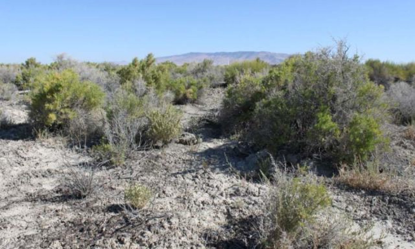
Figure 10. Saline Bottom Community Phase 2.3 NV 775 MU240 Wendore Soil T. Stringham August 2010
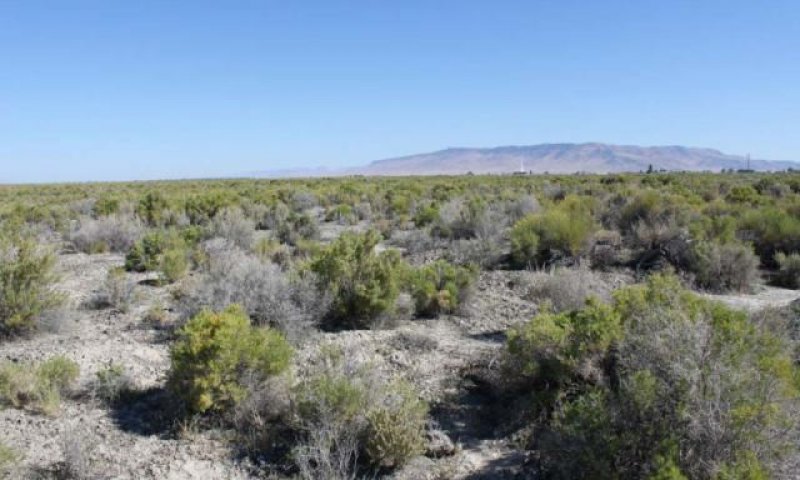
Figure 11. Saline Bottom Community Phase 2.3 NV 775 MU240 Wendore Soil T. Stringham August 2010
Black greasewood dominates the overstory and perennial bunchgrasses in the understory are reduced, either from competition with shrubs or from inappropriate grazing, or from both. Rabbitbrush may be a significant component. Annual non-native species are stable or increasing. This community is at risk of crossing a threshold to State 3.0.
Pathway 2.1a Community 2.1 to 2.2
This pathway is a result of wildfire removing vegetation cover and facilitating perennial grass cover to increase. Cover of sprouting shrubs will increase 1 to 2 seasons following fire.
Pathway 2.1b Community 2.1 to 2.3
This pathway is a result of prolonged drought resulting in temporary lowering of the water table or absence of disturbance and natural regeneration over time, favoring an increase in shrub cover.
Pathway 2.2a Community 2.2 to 2.1
This pathway is a result of the absence of disturbance facilitating natural regeneration over time.
Pathway 2.3a Community 2.3 to 2.1
This pathway is a result of a low severity patchy wildfire removing shrubs overstory and facilitating basin wildrye and other perennial grass to increase in cover. Release from drought also favors increased perennial grass production.
Pathway 2.3b Community 2.3 to 2.2
This pathway is a result of wildfire which removes vegetation and facilitates perennial grass cover to increase.
State 3 Shrub State
This state has two community phases, one that is characterized by a dominance of black greasewood overstory and the other with a rabbitbrush overstory. This site has crossed a biotic and abiotic threshold and site processes (infiltration/nutrient cycling) are being controlled by shrubs. Bare ground has increased.
Hydrology has been significantly altered through a decline in the water table leading to shrub dominance and a permanent reduction in the perennial grass understory.
Community 3.1 Community Phase
Black greasewood dominates the overstory. Rabbitbrush may be a significant component. Deep-rooted perennial bunchgrasses such as basin wildrye have significantly declined. Annual non-native species increase. Bare ground is significant.
Community 3.2 Community Phase
Rabbitbrush dominates the site. Perennial bunchgrasses are present but a minor component. Annual non-native species are present and may be increasing in the understory. Bare ground is abundant.
Pathway 3.1a Community 3.1 to 3.2
This pathway is a result of soil disturbing practices, long term drought leading to an increase in depth to water table facilitating a decline in black greasewood cover. Rabbitbrush and other shrub cover increases.
Transition T1A State 1 to 2
Trigger: This transition is caused by the introduction of non-native annual weeds, such as cheatgrass and Russian thistle.
Slow variables: Over time the annual non-native plants increase within the community.
Threshold: Any amount of introduced non-native species causes an immediate decrease in the resilience of the site. Annual non-native species cannot be easily removed from the system and have the potential to significantly alter disturbance regimes from their historic range of variation.
Transition T2A State 2 to 3
Trigger: To Community Phase 3.1: Inappropriate cattle/horse grazing will decrease or eliminate deep rooted perennial bunchgrasses and favor shrub growth and establishment.
To Community Phase 3.2: Soil disturbing brush treatments will reduce black greasewood and possibly increase non-native annual species. Lowering of the water table due to groundwater pumping will also decrease black greasewood and allow for rabbitbrush and other shrubs to increase.
Slow variables: Long term decrease in deep-rooted perennial grass density and/or black greasewood.
Threshold: Loss of deep-rooted perennial bunchgrasses changes nutrient cycling, nutrient redistribution, and reduces soil organic matter. Loss of long-lived, black greasewood changes the temporal and depending on the replacement shrub, the spatial distribution of nutrient cycling.
Restoration pathway R3A State 3 to 2
Restoration of this state would require mechanical or chemical brush treatment and
control of weedy annual species. Restoration may also require an increase in the water
table, including repair of incised channel(s) and/or reduced groundwater pumping. Seeding of grasses may be necessary if basin wildrye is severely reduced or no longer
present in the community. Fire is not a recommended treatment.
Additional community tables
Table 6. Community 1.1 plant community composition
Livestock Interpretations:
This site is suitable for livestock grazing. Grazing management should be keyed to dominant grasses and palatable shrubs production. The early growth and abundant production of basin wildrye make it a valuable source of forage for livestock. It is important forage for cattle and is readily grazed by cattle and horses in early spring and fall. Though coarse textured during the winter, basin wildrye may be utilized more frequently by livestock and wildlife when snow has covered low shrubs and other grasses. Alkali sacaton is a valuable forage species in arid and semiarid regions. Plants are tolerant to moderate grazing and can produce abundant herbage utilized by livestock. Saltgrass's value as forage depends primarily on the relative availability of other grasses of higher nutritional value and palatability. It can be an especially important late summer grass in arid environments after other forage grasses have deceased. Saltgrass is rated as a fair to good forage species only because it stays green after most other grasses dry. Livestock generally avoid saltgrass due to its coarse foliage. Saltgrass is described as an increaser under grazing pressure. Black greasewood is an important winter browse plant for domestic sheep and cattle. It also receives light to moderate use by domestic sheep and cattle during spring and summer months. Black greasewood contains soluble sodium and potassium oxalates that may cause poisoning and death in domestic sheep and cattle if large amounts are consumed in a short time. In general,
livestock forage only lightly on rubber rabbitbrush during the summer, but winter use can be heavy in some locations. Fall use is variable, but flowers are commonly used by livestock. A few leaves and the more tender stems may also be used.
Stocking rates vary over time depending upon season of use, climate variations, site, and previous and current management goals. A safe starting stocking rate is an estimated stocking rate that is fine tuned by the client by adaptive management through the year and from year to year.
Wildlife Interpretations:
Basin wildrye provides winter forage for mule deer, though use is commonly low compared to other native grasses. Basin wildrye provides summer forage for black-tailed jackrabbits. Because basin wildrye remains green throughout early summer, it remains available for small mammal forage for longer time than other grasses. The western salt desert shrub and grassland communities where alkali sacaton is common support an abundance of mule deer, pronghorn, carnivores, small mammals, birds, amphibians, and reptiles. Saltgrass provides cover for a variety of bird species, small mammals, and arthropods and is on occasion used as forage for several big game wildlife species. Black greasewood is an important winter browse plant for big game animals and a food source for many other wildlife species. It also receives light to moderate use by mule deer and pronghorn during spring and summer months. Wildlife forage only lightly on rubber rabbitbrush during the summer, but winter use can be heavy in some locations. Fall use is variable, but flowers are commonly used by wildlife. A few leaves and the more tender stems may also be used. The forage value of rubber rabbitbrush varies greatly among subspecies and ecotypes.
Hydrological functions
Runoff is low to very high. Permeability is slow to moderately slow. Hydrologic soil groups are B, C, and D.
Recreational uses
Aesthetic value is derived from the diverse floral and faunal composition and the colorful flowering of wild flowers and shrubs during the spring and early summer. This site offers rewarding opportunities to photographers and for nature study. This site has potential for upland bird and big game hunting.
Other products
Basin wildrye is used as bedding for various Native American ceremonies, providing a cool place for dancers to stand. The leaves, seeds and stems of black greasewood are edible.
Other information
Basin wildrye is useful in mine reclamation, fire rehabilitation and stabilizing disturbed areas. Its usefulness in range seeding, however, may be limited by initially weak stand establishment. Alkali sacaton is one of the most used species for seeding and stabilizing disturbed lands. Due to alkali sacaton’s salt tolerance, is recommended for native grass seeding on subirrigated saline sites. Given its extensive system of rhizomes and roots which form a dense sod, saltgrass is considered a suitable species for controlling wind and water erosion. Black greasewood is useful for stabilizing soil on wind-blown areas. It successfully revegetates eroded areas and sites too saline for most plant species.
Supporting information
Inventory data references
NASIS soil component data.
Type locality
Location 1: Lander County, NV
Township/Range/Section
T31N R45E S17
UTM zone
N
UTM northing
4490010
UTM easting
506009
Latitude
40° 33′ 39″
Longitude
116° 55′ 44″
General legal description
S½,Approximately 6 miles south of Battle Mountain, along east side of Marvel Ranch Road (Old 8A), Lander County, Nevada. This site also occurs in Elko, Eureka, Humboldt and Pershing Counties, Nevada.
Eckert, R.E., Jr., A.D. Bruner, and G.J. Klomp. 1973. Productivity of tall wheatgrass and great basin wildrye under irrigation on a greasewood – rabbitbrush range site. Journal of Range Management 26(4):286-288.
Krall, J.L., J.R. Stroh, C.S. Cooper, and S.R. Chapman. 1971. Effect of time and extent of harvesting on basin wildrye. Journal of Range Management 24:414-418.
Paysen, T.E., R.J. Ansley, and J.K. Brown. 2000. Fire in western shrubland, woodland, and grassland ecosystems. In: Brown, J.K. and J.K. Smith (eds). Wildland fire in ecosystems: Effects of fire on flora. Gen. Tech. Rep. RMRS-GTR-42-Volume 2. Ogden, UT. U.S. Department of Agriculture, Forest Service, Rocky Mountain Research Station. Pgs 121-159.
Roundy, B.A. 1985. Emergence and establishment of basin wildrye and tall wheatgrass in relation to moisture and salinity. Journal of Range Management 38(2):126-131.
Stuart, D.M., G.E. Schuman, and A.S. Dylla. 1971. Chemical characteristics of the coppice dune soils in Paradise Valley, Nevada. Proceedings of the Soil Science Society of America 34:607-611.
Young, J.A., R.A. Evans, and P.T. Tueller. 1975. Great Basin plant communities – pristine and grazed. Pgs 187-212, In: R. Elston (ed.). Holocene climate in the Great Basin, Occasional Papers, Nevada Archeological Survey, Reno NV.
Young, J.A. and R.A. Evans. 1981. Germination of Great Basin wildrye seeds collected from native stands. Agronomy Journal 73:917-920.
Zschaechner, G.A. 1985. Studying rangeland fire effects: a case study in Nevada. In: Sanders, K. and J. Durham (eds). Rangeland fire effects. Proceedings of the symposium. 1984 November 27-29; Boise, ID. Boise, ID. U.S. Department of the Interior, Bureau of Land Management, Idaho State Office. Pgs 66-84.
Contributors
CP/GKB E.Hourihan T Stringham P NovakEchenique
Approval
Kendra Moseley, 3/07/2025
Rangeland health reference sheet
Interpreting Indicators of Rangeland Health is a qualitative assessment protocol used to
determine ecosystem condition based on benchmark characteristics described in the Reference Sheet. A suite of 17 (or
more) indicators are typically considered in an assessment. The ecological site(s) representative of an assessment
location must be known prior to applying the protocol and must be verified based on soils and climate. Current plant
community cannot be used to identify the ecological site.
Author(s)/participant(s)
Patti Novak-Echenique
Contact for lead author
State Rangeland Management Specialist
Date
09/24/2009
Approved by
Kendra Moseley
Approval date
Composition (Indicators 10 and 12) based on
Annual Production
Indicators
Number and extent of rills:
Rills are typically none.
Presence of water flow patterns:
Water flow patterns are rare to common. Moderately fine to fine surface textures result in limited infiltration rates. Concentrations of surface
salts and sodium result in chemical crusts which also impedes precipitation infiltration. Water flow patterns are typically short, ending in
depressional areas.
Number and height of erosional pedestals or terracettes:
Pedestals are none.
Bare ground from Ecological Site Description or other studies (rock, litter, lichen, moss, plant canopy are
not bare ground):
Bare Ground ± 65 percent.
Number of gullies and erosion associated with gullies:
None
Extent of wind scoured, blowouts and/or depositional areas:
None
Amount of litter movement (describe size and distance expected to travel):
Fine litter (foliage of grasses and annual & perennial forbs) only expected to move during periods of flooding by adjacent streams.
Persistent litter (large woody material) will remain in place except during major flooding events.
Soil surface (top few mm) resistance to erosion (stability values are averages - most sites will show a range
of values):
Soil stability values will range from 1 to 4 (To be field tested).
Soil surface structure and SOM content (include type of structure and A-horizon color and thickness):
Structure of soil surface will be platy or massive. Soil surface colors are light and soils are typified by an ochric epipedon. Organic matter
can range from 1.5 to 4.5 percent (OM values taken from lab characterization data).
Effect of community phase composition (relative proportion of different functional groups) and spatial
distribution on infiltration and runoff:
Deep-rooted perennial grasses (basin wildrye and alkali sacaton] slow runoff and increase infiltration. Tall stature and relatively coarse foliage of basin wildrye and associated litter break raindrop impact and provide opportunity for snow catch and moisture accumulation on site.
Presence and thickness of compaction layer (usually none; describe soil profile features which may be
mistaken for compaction on this site):
Compacted layers are not typical. Platy or massive subsurface layers are normal for this site and are not to be interpreted as compaction.
Functional/Structural Groups (list in order of descending dominance by above-ground annual-production or live foliar
cover using symbols: >>, >, = to indicate much greater than, greater than, and equal to):
Amount of plant mortality and decadence (include which functional groups are expected to show mortality or
decadence):
Dead branches within individual shrubs common and standing dead shrub canopy material may be as much as 25 percent of total woody canopy.
Average percent litter cover (%) and depth ( in):
Within plant interspaces (± 35 percent) and depth of litter ± ½ inch.
Expected annual annual-production (this is TOTAL above-ground annual-production, not just forage annual-production):
For normal or average growing season (through end of May) ± 1400 lbs/ac; Winter moisture significantly affects total production
Potential invasive (including noxious) species (native and non-native). List species which BOTH characterize
degraded states and have the potential to become a dominant or co-dominant species on the ecological site if
their future establishment and growth is not actively controlled by management interventions. Species that become
dominant for only one to several years (e.g., short-term response to drought or wildfire) are not invasive
plants. Note that unlike other indicators, we are describing what is NOT expected in the reference state for the
ecological site:
Increasers include rubber rabbitbrush. Potential invaders include annual mustards, povertyweed, annual kochia, pigweed, and tall whitetop (perennial pepperweed).
Perennial plant reproductive capability:
All functional groups should reproduce in average (or normal) and above average growing season years.
The Ecosystem Dynamics Interpretive Tool is an information system framework developed by the USDA-ARS Jornada Experimental Range, USDA Natural Resources Conservation Service, and New Mexico State University.
Click on box and path labels to scroll to the respective text.
Trigger: This transition is caused by the introduction of non-native annual weeds, such as cheatgrass and Russian thistle.
Slow variables: Over time the annual non-native plants increase within the community.
Threshold: Any amount of introduced non-native species causes an immediate decrease in the resilience of the site. Annual non-native species cannot be easily removed from the system and have the potential to significantly alter disturbance regimes from their historic range of variation.
T2A
-
Trigger: To Community Phase 3.1: Inappropriate cattle/horse grazing will decrease or eliminate deep rooted perennial bunchgrasses and favor shrub growth and establishment.
To Community Phase 3.2: Soil disturbing brush treatments will reduce black greasewood and possibly increase non-native annual species. Lowering of the water table due to groundwater pumping will also decrease black greasewood and allow for rabbitbrush and other shrubs to increase.
Slow variables: Long term decrease in deep-rooted perennial grass density and/or black greasewood.
Threshold: Loss of deep-rooted perennial bunchgrasses changes nutrient cycling, nutrient redistribution, and reduces soil organic matter. Loss of long-lived, black greasewood changes the temporal and depending on the replacement shrub, the spatial distribution of nutrient cycling.
R3A
-
Restoration of this state would require mechanical or chemical brush treatment and
control of weedy annual species. Restoration may also require an increase in the water
table, including repair of incised channel(s) and/or reduced groundwater pumping. Seeding of grasses may be necessary if basin wildrye is severely reduced or no longer
present in the community. Fire is not a recommended treatment.
This pathway is a result of wildfire which removes vegetation cover and allows perennial grass cover to increase. Cover of sprouting shrubs will increase 1 to 2 seasons following fire.
1.1b
-
This pathway is a result of prolonged drought resulting in temporary lowering of the water table or absence of disturbance and natural regeneration over time favoring an increase in shrub cover.
1.2A
-
This pathway is a result of time which allows for re-establishment of black greasewood and other shrubs after fire.
1.2B
-
This pathway is a result of a temporary increase in depth to water table due to extended
drought or inadequate rest from herbivory.
1.3A
-
This pathway is a result of adequate prescribed grazing or release from drought facilitating the perennial grass cover to increase over time.
This pathway is a result of wildfire removing vegetation cover and facilitating perennial grass cover to increase. Cover of sprouting shrubs will increase 1 to 2 seasons following fire.
2.1b
-
This pathway is a result of prolonged drought resulting in temporary lowering of the water table or absence of disturbance and natural regeneration over time, favoring an increase in shrub cover.
2.2a
-
This pathway is a result of the absence of disturbance facilitating natural regeneration over time.
2.3a
-
This pathway is a result of a low severity patchy wildfire removing shrubs overstory and facilitating basin wildrye and other perennial grass to increase in cover. Release from drought also favors increased perennial grass production.
2.3b
-
This pathway is a result of wildfire which removes vegetation and facilitates perennial grass cover to increase.
This pathway is a result of soil disturbing practices, long term drought leading to an increase in depth to water table facilitating a decline in black greasewood cover. Rabbitbrush and other shrub cover increases.