
Natural Resources
Conservation Service
Ecological site R024XY008OR
CLAYEY PLAYETTE
Accessed: 04/11/2025
General information
Provisional. A provisional ecological site description has undergone quality control and quality assurance review. It contains a working state and transition model and enough information to identify the ecological site.

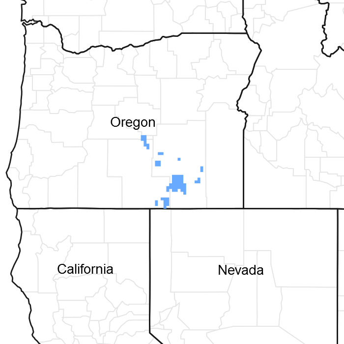
Figure 1. Mapped extent
Areas shown in blue indicate the maximum mapped extent of this ecological site. Other ecological sites likely occur within the highlighted areas. It is also possible for this ecological site to occur outside of highlighted areas if detailed soil survey has not been completed or recently updated.
Ecological site concept
This ecological site is mostly mapped in MLRA 23. Soils are well drained with an ochric epipdeon, other characteristics are unclear. ESC needs work.
Associated sites
R024XY004OR |
DRY FLOODPLAIN 6-10 PZ Dry Floodplain (very deep loamy soil, high production, LECI4 dominant) |
---|---|
R024XY016OR |
LOAMY 8-10 PZ Loamy 8-10 PZ (upland site, moderately deep loam, higher production, different composition ARTRW8/ACTH7-PSSPS-ACHY association) |
R024XY123OR |
LOW CLAYEY TERRACE 8-10 PZ Low Clayey Terrace 8-10 PZ (higher production, thicker surface, clayey subsoil contact not as abrupt, different composition – PSSPS dominant grass) |
Similar sites
R024XY123OR |
LOW CLAYEY TERRACE 8-10 PZ Low Clayey Terrace 8-10 PZ (higher production, thicker surface, clayey subsoil contact not as abrupt, different composition – PSSPS dominant grass) |
---|
Table 1. Dominant plant species
Tree |
Not specified |
---|---|
Shrub |
(1) Artemisia tridentata subsp. wyomingensis |
Herbaceous |
(1) Elymus elymoides |
Physiographic features
This site occurs in dry lake basins and valley floors. It is typically found on the flat valley floor. The site appears as a dry playa with regular pattern of very small coppices and playettes. Slopes range from 0-3 percent and elevations from 4000 to 4600 feet.
Table 2. Representative physiographic features
Landforms |
(1)
Basin floor
(2) Lakebed (3) Valley floor |
---|---|
Ponding duration | Brief (2 to 7 days) to very brief (4 to 48 hours) |
Ponding frequency | Occasional to rare |
Elevation | 1,219 – 1,402 m |
Aspect | Aspect is not a significant factor |
Climatic features
The annual precipitation ranges from 6 to 10 inches, most of which occurs in the form of snow and rain during the months of December through March. Localized convection storms occasionally occur during the summer. The soil temperature is mesic to frigid near mesic with a mean air temperature of 48 degrees F. Temperature extremes range from 100 to -10 degrees F. The frost-free period ranges from 90 to 120 days. The optimum period for plant growth is from April through early June.
Table 3. Representative climatic features
Frost-free period (average) | 120 days |
---|---|
Freeze-free period (average) | 0 days |
Precipitation total (average) | 254 mm |
Figure 2. Monthly average minimum and maximum temperature
Influencing water features
Soil features
The soils of this site are fine textured, very deep and somewhat poorly drained. The surface layer is a strong vesicular crust approximately 3 inches thick over a contrasting clay subsoil. Slight wind deposited coppice mounds with sage occur in a regular pattern. Ponding typically occurs for short periods in the spring. Permeability is moderately slow to slow. The availabe water holding capacity (AWC) is 6 to 10 inches. Depth to water table is normally greater than 60 inches.
Table 4. Representative soil features
Parent material |
(1)
Eolian deposits
–
rhyolite
|
---|---|
Surface texture |
(1) Silty clay loam |
Family particle size |
(1) Clayey |
Drainage class | Somewhat poorly drained to poorly drained |
Permeability class | Moderately slow to slow |
Soil depth | 183 cm |
Ecological dynamics
The reference native plant community on the scattered small coppice mounds is dominated by Wyoming big sagebrush. Bottlebrush squirreltail and lesser amounts of Sandberg bluegrass dominate the grass/forb layer under the Wyoming sagebrush. Sandberg bluegrass is scattered on the strongly contrasting bare playette. Forbs are a minor component. The potential vegetative composition is approximately 55 perrcent grass, 40 percent shrubs and 5 percent forbs. The approximate ground cover is 20-40 percent (basal and crown).
Four states have been identified for this site: a reference state; a state with the presence of annuals; a state with a shrub/annual co-dominance; and a state with annual dominance.
Reference: Plant community phase change is driven by infrequent fire. Wyoming and basin big sagebrush decline after fire while Thurber’s needlegrass, Indian ricegrass and other grasses increase. May see a temporary increase in rabbitbrush after fire. Time facilitates the reintroduction of sagebrush. The introduction of invasive annual grasses and forbs transitions into the state 2.
State 2: Compositionally similar to the reference state with a trace of cheatgrass and weedy forbs. Ecological function has not changed, however the resiliency of the state has been reduced by the presence of invasive weeds. Prescribed grazing and infrequent fire (> 50 year return interval) maintain state dynamics. The timing and/or intensity of grazing or prolonged drought favors Wyoming and basin big sagebrush, squirreltail and Sandberg’s bluegrass. Prescribed grazing and/or release from drought may reverse the decline in needlegrass and Indian ricegrass production. Infrequent fire reduces the shrub community and promotes the bunchgrass component. Mismanaged grazing and/or prolonged drought leads to a biotic threshold and into state 3.
State 3: Wyoming and basin big sagebrush is decadent with little recruitment. The perennial grass component is significantly reduced in both density and productivity. Cheatgrass and/or annual forbs and/or Sandberg’s bluegrass along with sagebrush control site resources and drive ecological dynamics. Bare ground is abundant. Spatial and temporal energy capture and nutrient cycling has been truncated. Infiltration may be reduced due to lack of ground cover. Risk of soil erosion by both wind and water is increased. Catastrophic wildfire will lead to an abiotic threshold and into state 4.
State 4: Cheatgrass and/or annual weed dominated plant community with limited to no shrub or perennial grass component. Soil erosion and redistribution along with changes in dynamic soil properties affect the hydrologic cycle and thus the nutrient cycle. Harsh environmental factors increase state resiliency to change.
Range in Characteristics-
This site is uniform in appearance with little variation. Production varies with coppice mound soil depth and spacing. The playette area contributes little toward production and Wyoming big sagebrush and bunchgrasses occur only on the coppice mounds.
Reponse to Disturbance-States
If heavy grazing causes site deterioration, bottlebrush squirreltail and Sandberg bluegrass decreases. With further deterioration the extent of bare playette area rapidly increases, Wyoming big sagebrush decreases and annual forbs and grasses weakly invade on the small coppice mounds remnants.
States: States: ARTRW8/POSE – bare ground; ARTRW8/Annuals – extensive bare ground playettes
State and transition model

Figure 3. Group 6, STM
More interactive model formats are also available.
View Interactive Models
More interactive model formats are also available.
View Interactive Models
Click on state and transition labels to scroll to the respective text
Ecosystem states
State 1 submodel, plant communities
State 1
Reference Plant Community
Community 1.1
Reference Plant Community
The reference native plant community on the scattered small coppice mounds is dominated by Wyoming big sagebrush. Bottlebrush squirreltail and lesser amounts of Sandberg bluegrass dominate the grass/forb layer under the Wyoming sagebrush. Sandberg bluegrass is scattered on the strongly contrasting bare playette. Forbs are a minor component. The potential vegetative composition is approximately 55 perrcent grass, 40 percent shrubs and 5 percent forbs. The approximate ground cover is 20-40 percent (basal and crown).
Figure 4. Annual production by plant type (representative values) or group (midpoint values)
Table 5. Annual production by plant type
Plant type | Low (kg/hectare) |
Representative value (kg/hectare) |
High (kg/hectare) |
---|---|---|---|
Grass/Grasslike | 62 | 185 | 247 |
Shrub/Vine | 45 | 135 | 179 |
Forb | 6 | 17 | 22 |
Total | 113 | 337 | 448 |
Additional community tables
Table 6. Community 1.1 plant community composition
Group | Common name | Symbol | Scientific name | Annual production (kg/hectare) | Foliar cover (%) | |
---|---|---|---|---|---|---|
Grass/Grasslike
|
||||||
1 | Dominant, perennial, moderate rooted bunchgrass | 67–101 | ||||
squirreltail | ELEL5 | Elymus elymoides | 67–101 | – | ||
2 | Sub-dominant, perennial, shallow rooted grass | 34–67 | ||||
Sandberg bluegrass | POSE | Poa secunda | 34–67 | – | ||
3 | Other perennial grasses | 13–40 | ||||
Indian ricegrass | ACHY | Achnatherum hymenoides | 3–10 | – | ||
Thurber's needlegrass | ACTH7 | Achnatherum thurberianum | 3–10 | – | ||
basin wildrye | LECI4 | Leymus cinereus | 3–10 | – | ||
beardless wildrye | LETR5 | Leymus triticoides | 3–10 | – | ||
bluebunch wheatgrass | PSSPS | Pseudoroegneria spicata ssp. spicata | 3–10 | – | ||
Forb
|
||||||
4 | Perennial forbs | 7–27 | ||||
cushion buckwheat | EROV | Eriogonum ovalifolium | 2–10 | – | ||
rock buckwheat | ERSP7 | Eriogonum sphaerocephalum | 2–10 | – | ||
desertparsley | LOMAT | Lomatium | 2–10 | – | ||
longleaf phlox | PHLO2 | Phlox longifolia | 2–10 | – | ||
onion | ALLIU | Allium | 2–7 | – | ||
Shrub/Vine
|
||||||
5 | Dominant, evergreen, non-sprouting shrub | 67–101 | ||||
Wyoming big sagebrush | ARTRW8 | Artemisia tridentata ssp. wyomingensis | 67–101 | – | ||
6 | Other shrubs | 3–10 | ||||
yellow rabbitbrush | CHVI8 | Chrysothamnus viscidiflorus | 0–7 | – |
Interpretations
Animal community
Livestock grazing-
This site suited to fall and winter use by cattle, sheep, and horses under a planned grazing system. The key species is bottlebrush squirreltail. This species can be damaged if heavily grazed during periods of flowering and seed formation before root reserves have accumulated. Plant crowns can be damaged if grazed during spring periods while the soils are wet.
Wildlife-
This site is commonly occupied by small mammals and their associated predators. Mule deer and antelope will use this site during the fall and winter. This site provides limited cover and food for wildlife. Various birds, rabbits, and rodents make use of this site.
Hydrological functions
Watershed-
The soils of this site are typically near the lowest topographic position and when ponded have little runoff potential. Ponding is extended because of very low soil intake rates. As a result of low plant density the hydrologic cover condition is fair, even when the ecological condition is high.
Other information
This site has poor potential for range seeding because of the thick vesicular crust, contrasting clay subsoil and droughtiness of the site. Disturbing the vesicular crust and mixing it with the subsoil provides a slightly improved micro-environment for seedling establishment.
Supporting information
Contributors
CT,TB,AB
J.Joye(OSU)
JPR
SCS/BLM Team, Hines
Rangeland health reference sheet
Interpreting Indicators of Rangeland Health is a qualitative assessment protocol used to determine ecosystem condition based on benchmark characteristics described in the Reference Sheet. A suite of 17 (or more) indicators are typically considered in an assessment. The ecological site(s) representative of an assessment location must be known prior to applying the protocol and must be verified based on soils and climate. Current plant community cannot be used to identify the ecological site.
Author(s)/participant(s) | Jeff Repp |
---|---|
Contact for lead author | State Rangeland Management Specialist for NRCS Oregon |
Date | 11/17/2016 |
Approved by | Bob Gillaspy |
Approval date | |
Composition (Indicators 10 and 12) based on | Annual Production |
Indicators
-
Number and extent of rills:
None, slight sheet & rill erosion hazard. -
Presence of water flow patterns:
None, except following extremely high intensity storms or ponding in the spring when short (less than 1 meter) flow patterns may appear. Minimal evidence of past or current soil deposition or erosion. -
Number and height of erosional pedestals or terracettes:
None. -
Bare ground from Ecological Site Description or other studies (rock, litter, lichen, moss, plant canopy are not bare ground):
15-40% -
Number of gullies and erosion associated with gullies:
None. -
Extent of wind scoured, blowouts and/or depositional areas:
None to some deposited coppice mounds. Slight wind erosion hazard. -
Amount of litter movement (describe size and distance expected to travel):
Litter size is Small/Fine. Litter movement is limited, minimal, and short, associated with water flow patterns following extremely high intensity storms or ponding in the spring. Litter also may be moved during intense wind storms. -
Soil surface (top few mm) resistance to erosion (stability values are averages - most sites will show a range of values):
Site is Moderately resistant to erosion. Stability class (Herrick et al. 2001) anticipated to be 3-6 at surface under perennial vegetation. Stability class at surface in the interspaces is anticipated to be less than or equal to that under perennial vegetation. -
Soil surface structure and SOM content (include type of structure and A-horizon color and thickness):
Surface layer structure is weak thin platy to moderate medium platy. The A horizon has a dry color of 5 - 7 and is 1 - 4 inches thick. The Soil Organic Matter (SOM) content is low (0.3 to 2.0%). -
Effect of community phase composition (relative proportion of different functional groups) and spatial distribution on infiltration and runoff:
Plant foliar cover and basal cover with large gaps between plants should moderately reduce raindrop impact and slow overland flow, providing some increased time for infiltration to occur. Herbaceous vegetation on this site will retain some water from precipitation. Low ground cover (20-40%) and gentle slopes (0-3%) moderately limit rainfall impact and overland flow. -
Presence and thickness of compaction layer (usually none; describe soil profile features which may be mistaken for compaction on this site):
None. -
Functional/Structural Groups (list in order of descending dominance by above-ground annual-production or live foliar cover using symbols: >>, >, = to indicate much greater than, greater than, and equal to):
Dominant:
Deep rooted bunchgrasses = evergreen shrubsSub-dominant:
Shallow rooted bunchgrassesOther:
Other perennial grasses = > perennial forbs > other shrubsAdditional:
-
Amount of plant mortality and decadence (include which functional groups are expected to show mortality or decadence):
Grasses will nearly always show some
mortality and decadence. Normal decadence and mortality expected on other plants. -
Average percent litter cover (%) and depth ( in):
-
Expected annual annual-production (this is TOTAL above-ground annual-production, not just forage annual-production):
Low 100 lbs/acre, Representative Value 300 lbs/acre, High 400 lbs/acre -
Potential invasive (including noxious) species (native and non-native). List species which BOTH characterize degraded states and have the potential to become a dominant or co-dominant species on the ecological site if their future establishment and growth is not actively controlled by management interventions. Species that become dominant for only one to several years (e.g., short-term response to drought or wildfire) are not invasive plants. Note that unlike other indicators, we are describing what is NOT expected in the reference state for the ecological site:
Annual grasses (Cheatgrass and Medusahead) and annual forbs invade sites that have lost deep rooted perennial grass functional groups. -
Perennial plant reproductive capability:
All species should be capable of reproducing annually.
Print Options
Sections
Font
Other
The Ecosystem Dynamics Interpretive Tool is an information system framework developed by the USDA-ARS Jornada Experimental Range, USDA Natural Resources Conservation Service, and New Mexico State University.
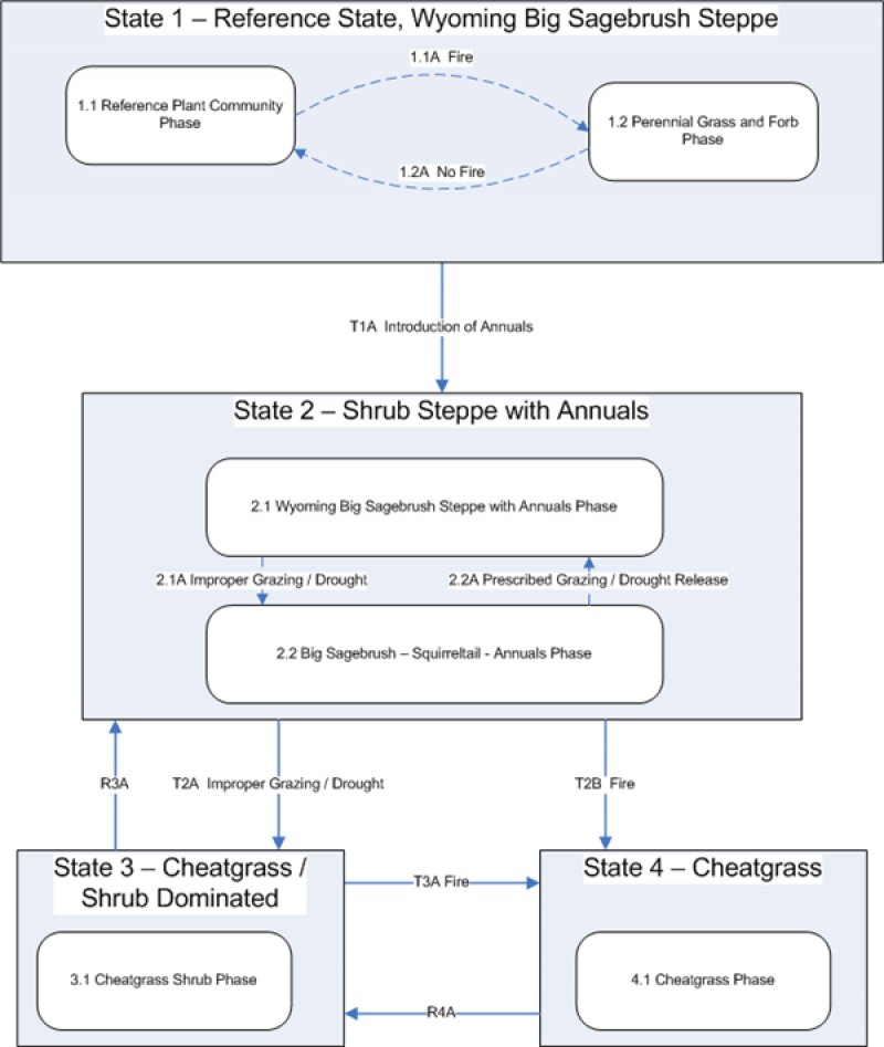
Click on box and path labels to scroll to the respective text.