Natural Resources
Conservation Service
Ecological site R024XY010NV
SODIC FLOODPLAIN
Last updated: 3/07/2025
Accessed: 03/30/2026
General information
Provisional. A provisional ecological site description has undergone quality control and quality assurance review. It contains a working state and transition model and enough information to identify the ecological site.
MLRA notes
Major Land Resource Area (MLRA): 024X–Humboldt Basin and Range Area
Major land resource area (MLRA) 24, the Humboldt Area, covers an area of approximately 8,115,200 acres (12,680 sq. mi.). It is found in the Great Basin Section of the Basin and Range Province of the Intermontane Plateaus. Elevations range from 3,950 to 5,900 feet (1,205 to 1,800 meters) in most of the area, some mountain peaks are more than 8,850 feet (2,700 meters).
A series of widely spaced north-south trending mountain ranges are separated by broad valleys filled with alluvium washed in from adjacent mountain ranges. Most valleys are drained by tributaries to the Humboldt River. However, playas occur in lower elevation valleys with closed drainage systems. Isolated ranges are dissected, uplifted fault-block mountains. Geology is comprised of Mesozoic and Paleozoic volcanic rock and marine and continental sediments. Occasional young andesite and basalt flows (6 to 17 million years old) occur at the margins of the mountains. Dominant soil orders include Aridisols, Entisols, Inceptisols and Mollisols. Soils of the area are generally characterized by a mesic soil temperature regime, an aridic soil moisture regime and mixed geology. They are generally well drained, loamy and very deep.
Approximately 75 percent of MLRA 24 is federally owned, the remainder is primarily used for farming, ranching and mining. Irrigated land makes up about 3 percent of the area; the majority of irrigation water is from surface water sources, such as the Humboldt River and Rye Patch Reservoir. Annual precipitation ranges from 6 to 12 inches (15 to 30 cm) for most of the area, but can be as much as 40 inches (101 cm) in the mountain ranges. The majority of annual precipitation occurs as snow in the winter. Rainfall occurs as high-intensity, convective thunderstorms in the spring and fall.
Ecological site concept
This ecological site is on lake plains and stream terraces. Soils are very deep, somewhat poorly drained and formed in alluvium derived from mixed sources. The soil profile is saline-sodic with a pH of 9.0 at the surface, EC of 4-32 and SAR of 13-90.
Important abiotic factors contributing to the presence of this site include the strongly saline-sodic conditions in the soil profile and shallow depth to a water table.
Full consideration should be given to correlating to 024XY044NV to this ESC as a CP.
Associated sites
| R024XY007NV |
SALINE BOTTOM This ecological site is on alluvial flats, stream terraces and flood plains. Soils are very deep, somewhat poorly drained and formed in alluvium derived from mixed alluvium, loess and volcanic ash. |
|---|---|
| R024XY011NV |
SODIC FLAT 6-8 P.Z. This ecological site is on alluvial flats, soils are deep, poorly to somewhat poorly drained, and the soil profile is characterized by an ochric epipedon. |
| R024XY009NV |
SALINE MEADOW This ecological site is on floodplains and inset fans. Soils are very deep, poorly drained and formed in alluvium derived from mixed parent material. The soil profile is characterized by a fine sand surface texture. |
Similar sites
| R024XY011NV |
SODIC FLAT 6-8 P.Z. Much less productive site. Greasewood (SAVE4), Basin wildrye (LECI4) |
|---|---|
| R024XY009NV |
SALINE MEADOW More productive site. Alcali sacaton (SPAI) dominant grass and Scratchgrass (MUAS) co-dominant grass. |
| R024XY007NV |
SALINE BOTTOM More productive site; Basin wildrye (LECI4) dominant plant and Greasewood (SAVE4) codominant plant. |
Table 1. Dominant plant species
| Tree |
Not specified |
|---|---|
| Shrub |
(1) Allenrolfea occidentalis |
| Herbaceous |
(1) Sporobolus airoides |
Physiographic features
This site is on lake plain terraces, flood plains, and alluvial flats. Slopes range from 0 to 8 percent, but slope gradients of 0 to 2 percent are most typical. Elevations are 3900 to 5700 feet. (1189 to 1737 meters).
Table 2. Representative physiographic features
| Landforms |
(1)
Lake plain
(2) Flood plain (3) Alluvial flat |
|---|---|
| Runoff class | Medium to very high |
| Flooding duration | Very brief (4 to 48 hours) to long (7 to 30 days) |
| Flooding frequency | Rare to occasional |
| Ponding frequency | None |
| Elevation | 3,900 – 5,700 ft |
| Slope | 2% |
| Water table depth | 27 – 84 in |
| Aspect | Aspect is not a significant factor |
Climatic features
The climate is semiarid, characterized by cold, moist winters, and warm, somewhat dry summers. Average annual precipitation is 6 to 10 inches. Mean annual air temperature is 45 to 52 degrees F. The average growing season is about 90 to 130 days.
Table 3. Representative climatic features
| Frost-free period (average) | 130 days |
|---|---|
| Freeze-free period (average) | |
| Precipitation total (average) | 10 in |
Figure 1. Monthly average minimum and maximum temperature
Influencing water features
This site is associated with perennial streams and dry lake beds and receives additional moisture during spring runoff and convective summer storms.
Soil features
The soils are very deep, somewhat poorly drained and formed in alluvium derived from mixed sources. The soil profile is saline-sodic. A water table is found between 46 to 100 centimeters (18 to 39 in) in the spring.
These soils are strongly salty, and sodium affected with a very high concentration of salts at or near the surface due to capillary movement of dissolved salts upward from the ground water. High salt concentrations reduce the available water capacity of these soils and adversely affect seed viability and germination. Soil series associated with this site includes; Duffer, Prida, and Umberland.
Where this site is correlated to Rixie and Prideen field investigation is need, and a more appropriate soil or site is needed.
Table 4. Representative soil features
| Parent material |
(1)
Volcanic ash
(2) Alluvium (3) Lacustrine deposits |
|---|---|
| Surface texture |
(1) Silt loam (2) Silty clay loam (3) Very fine sandy loam |
| Family particle size |
(1) Loamy |
| Drainage class | Poorly drained to somewhat poorly drained |
| Permeability class | Very slow to moderately slow |
| Soil depth | 72 – 84 in |
| Surface fragment cover <=3" | 4% |
| Surface fragment cover >3" | Not specified |
| Available water capacity (0-40in) |
6.3 – 7.9 in |
| Calcium carbonate equivalent (0-40in) |
60% |
| Electrical conductivity (0-40in) |
4 – 32 mmhos/cm |
| Sodium adsorption ratio (0-40in) |
46 – 100 |
| Soil reaction (1:1 water) (0-40in) |
8 – 9.6 |
| Subsurface fragment volume <=3" (Depth not specified) |
4% |
| Subsurface fragment volume >3" (Depth not specified) |
Not specified |
Table 5. Representative soil features (actual values)
| Drainage class | Not specified |
|---|---|
| Permeability class | Not specified |
| Soil depth | Not specified |
| Surface fragment cover <=3" | Not specified |
| Surface fragment cover >3" | Not specified |
| Available water capacity (0-40in) |
Not specified |
| Calcium carbonate equivalent (0-40in) |
Not specified |
| Electrical conductivity (0-40in) |
Not specified |
| Sodium adsorption ratio (0-40in) |
13 – 90 |
| Soil reaction (1:1 water) (0-40in) |
7.4 – 9.6 |
| Subsurface fragment volume <=3" (Depth not specified) |
Not specified |
| Subsurface fragment volume >3" (Depth not specified) |
Not specified |
Ecological dynamics
An ecological site is the product of all the environmental factors responsible for its development and it has a set of key characteristics that influence a site’s resilience to disturbance and resistance to invasives. Key characteristics include 1) climate (precipitation, temperature), 2) topography (aspect, slope, elevation, and landform), 3) hydrology (infiltration, runoff), 4) soils (depth, texture, structure, organic matter), 5) plant communities (functional groups, productivity), and 6) natural disturbance regime (fire, herbivory, etc.) (Caudle et al 2013). Biotic factors that influence resilience include site productivity, species composition and structure, and population regulation and regeneration (Chambers et al. 2013).
The Great Basin shrub communities have high spatial and temporal variability in precipitation, both among years and within growing seasons. Nutrient availability is typically low but increases with elevation and closely follows moisture availability. The moisture resource supporting the greatest amount of plant growth is usually the water stored in the soil profile during the winter. The invasibility of plant communities is often linked to resource availability. Disturbance can decrease resource uptake due to damage or mortality of the native species and depressed competition or can increase resource pools by the decomposition of dead plant material following disturbance.
282
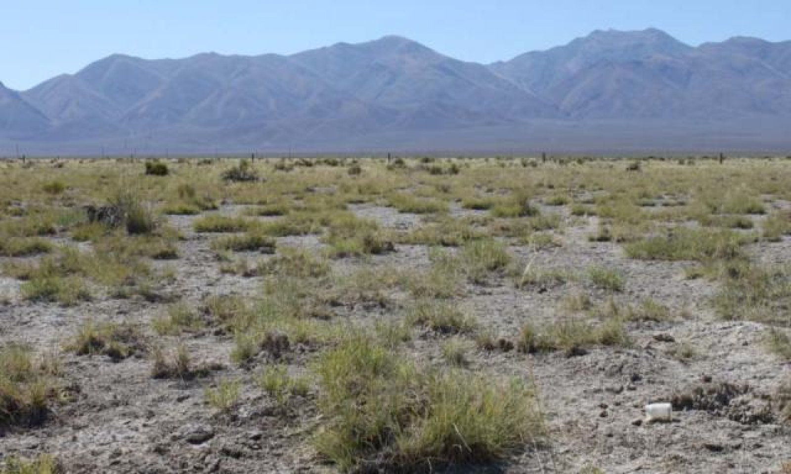
These salt-desert shrub communities are dominated by phreatophytes that depend for their water supply upon ground water that lies within reach of their roots. The Sodic Floodplain site is characterized by unvegetated playa areas interspersed with small vegetated mounds dominated by iodinebush and alkali sacaton. The plants on this site are halophytes, meaning they are highly tolerant of saline soil conditions. Halophytes tend to be smaller in size in areas with concentrated salt, and larger in less saline conditions (Flowers 1934). Halophyte seeds remain viable for long periods of time under saline conditions and tend to germinate in the spring when salt concentrations are reduced due to precipitation (Unger 1982, Gul and Weber 1999, Khan et al 2000). Blank et al (1998) studied an area with iodinebush on mounds and found that the mounds seemed to form periodically; mounds had mature vegetation but were too saline to allow recruitment. It was hypothesized that when mature plants die, mounds tend to erode. Only upon new mound formation would these species be able to germinate.
Iodinebush is a chenopod and a C3 halophytic plant that grows in the arid environment of the Western United States where halomorphic soil induces extreme osmotic stress with erratic and low precipitation during the growing period. Iodinebush is generally found on eolian mounds at the margins of salt marshes and salt playas (Trent et al 1997, Gul and Weber 1999). These mounds average 0.3 meters in height and appear to be favorable for plant recruitment and survivorship, however this value is lost after a number of years because of accumulation of salts (Blank et al 1998). Iodinebush grows well in soils with 6% sodium chloride (NaCl). It is one of the most salt tolerant species in salt playas of the Great Basin. The dry summer season allows for salt to accumulate on the soil surface which prevents most plants from growing, except for iodinebush (Weber et al. 2002). Iodinebush roots were extracted from a mound and found that roots extended over 10 meters into the unvegetated playa (Blank et al 1998). The diameter of larger roots was over 5 cm, and many had between 90 and 120 growth rings, indicating that iodinebush is quite long-lived. Iodinebush relies on a persistent seedbank that can remain dormant until salinity stress is alleviated (Gul and Weber 2001). The large taproot of iodinebush can reach water table depths to 25 feet (Meinzer 1927).
Alkali sacaton is a native long-lived, warm-season, densely tufted perennial bunchgrass ranging from 20 to 40 inches in height (Dayton 1931). It is considered a phreatophyte and a facultative wetland species in this region (USDA, NRCS 2015). It usually grows on saline soils but is not restricted to saline soils and can be found on nonsaline soils, rocky sites, open plains, valleys and bottom lands (Dayton 1931). Alkali sacaton has deep, coarse roots allowing it reach water tables at depths from 4 to 27 feet (Meinzer 1927). It reproduces from seeds and tillers and is a prolific seed producer. The seeds remain viable for several years because of the hard, waxy seed coats (USDA-Forest Service 1988).
Marcum and Kopec (1997) found inland saltgrass more tolerant of increased levels of salinity than alkali sacaton therefore dewatering and/or long term drought causing increased levels of salinity would create environmental conditions more favorable to inland saltgrass over alkali sacaton. Alkali sacaton is considered a facultative wet species in this region; therefore it is not drought tolerant. A lowering of the water table can occur with ground water pumping in these sites. This may contribute to the loss of deep rooted species such as greasewood and basin wildrye and an increase in rabbitbrush, shadscale (Atriplex confertifolia) and other species with the absence of drought.
This ecological site has low resilience to disturbance and resistance to invasion. Fire is not a typical disturbance in these sparsely vegetated communities. Changes in hydrology will affect plant communities; for example, lowering of the water table will decrease the herbaceous understory and eventually affect shrub species as well. If the soils in this are excessively disturbed, soil blowouts,
followed by ponding may lead to the formation of small playettes and loss of vegetation for a time. There is a greater risk of this occurring in areas with high off-highway vehicle (OHV) use. It has been observed that soil disturbance appeared to enable vegetation recruitment (Blank et al 1998), but no further research has verified this. In the presence of non-native invasive weeds, soil disturbance could allow further invasion. The introduction of annual weedy species, like halogeton (Halogeton glomeratus), may cause an increase in fire frequency and eventually lead to an annual state. One possible alternative stable state has been identified.
Fire Ecology:
Historically, salt-desert shrub communities had sparse understories and bare soil in intershrub spaces, making these communities somewhat resistant to fire (Young 1983, Paysen et al. 2000). They may burn only during high fire hazard conditions; for example, years with high precipitation can result in almost continuous fine fuels, increasing fire hazard (West 1994, Paysen et al. 2000).
Alkali sacaton is tolerant of, but not resistant to fire. Recovery of alkali sacaton after fire has been reported as 2 to 4 years (Bock and Bock 1978). Alkali sacaton is tolerant of fire, but can be killed by severe fire. Summer fires are more detrimental than winter fires. Recovery is typically two to four years (Newman and Gates 2000).
Loren and Kadlec (1985) found that fire followed by flooding one week later eliminated saltgrass from a Utah salt marsh; they found that although fire did not kill the plant’s rhizomes, the grass was not able to recover after flooding. Without immediate flooding, saltgrass may actually increase in cover after fire (de Szalay and Resh 1997).
State and transition model

Figure 2. T. Stringham 8/2016

Figure 3. Legend 2016
More interactive model formats are also available.
View Interactive Models
More interactive model formats are also available.
View Interactive Models
Click on state and transition labels to scroll to the respective text
Ecosystem states
State 1 submodel, plant communities
State 2 submodel, plant communities
State 1
Reference State
This is stable state. Community phase changes are a function of hydrology and drought. The existence of the reference community today is rare. Fire did not play a significant role in the community phase dynamics due to the overall low production.
Community 1.1
Reference Plant Community 1.1
Alkali sacaton and iodine bush dominate the site. Mojave seablite, black greasewood, saltgrass, and basin wildrye make up minor components. Potential vegetative composition is about 70% grasses, 5% forbs and 25% shrubs. Approximate ground cover (basal and crown) is 5 to 15 percent.
Figure 4. Annual production by plant type (representative values) or group (midpoint values)
Table 6. Annual production by plant type
| Plant type | Low (lb/acre) |
Representative value (lb/acre) |
High (lb/acre) |
|---|---|---|---|
| Grass/Grasslike | 105 | 210 | 315 |
| Shrub/Vine | 38 | 75 | 113 |
| Forb | 7 | 15 | 22 |
| Total | 150 | 300 | 450 |
Community 1.2
Plant community 1.2
Drought will favor shrubs. Rabbitbrush will increase and perennial grass production will decline along with iodinebush.
Pathway 1.1A
Community 1.1 to 1.2
Long-term chronic drought with water table decline.
Pathway 1.2A
Community 1.2 to 1.1
Release from drought – specifically spring; this may require multiple wet years; and/or water table recovery.
State 2
Current Potential State
This state is similar to the Reference State (1). Ecological function has not changed, however the resiliency of the state has been reduced by the presence of invasive non-native species.
Community 2.1
Plant community 2.1
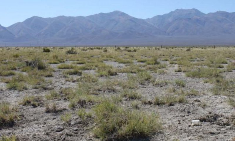
Figure 5. T. Stringham 2010 NV775, MU340 Duffer series
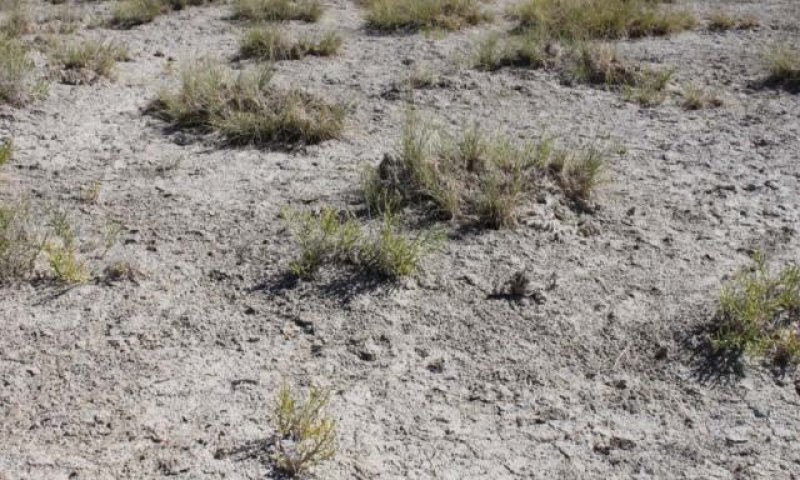
Figure 6. T. Stringham 8/2010, NV775 MU340 Duffer series
This community is dominated by iodinebush and alkali sacaton. Black greasewood, saltgrass, and basin wildrye make up minor components. Annual non-native species such as halogeton and Russian thistle are present and may be increasing within the community. Salt cedar may occur in disturbed areas where water has ponded.
Community 2.2
Plant community 2.2
Inland saltgrass increases and alkali sacaton decreases. Rabbitbrush, black greasewood, iodinebush, sickle saltbush, and povertyweed may increase. Bare ground is increasing. Other perennial bunchgrasses such as saltgrass and basin wildrye may decrease. Halogeton and other annual weedy species are present.
Pathway 2.1A
Community 2.1 to 2.2
Inappropriate rest and recovery from defoliation and/or long-term drought.
Pathway 2.2A
Community 2.2 to 2.1
Release from drought and/or prescribed grazing.
Transition T1A
State 1 to 2
This transition is caused by the introduction of non-native annual weeds.
Additional community tables
Table 7. Community 1.1 plant community composition
| Group | Common name | Symbol | Scientific name | Annual production (lb/acre) | Foliar cover (%) | |
|---|---|---|---|---|---|---|
|
Grass/Grasslike
|
||||||
| 1 | Primary Perennial Grasses | 186–240 | ||||
| alkali sacaton | SPAI | Sporobolus airoides | 180–210 | – | ||
| saltgrass | DISP | Distichlis spicata | 6–30 | – | ||
| 2 | Secondary Perennial Grasses | 6–15 | ||||
| basin wildrye | LECI4 | Leymus cinereus | 2–9 | – | ||
| alkaligrass | PUCCI | Puccinellia | 2–9 | – | ||
|
Forb
|
||||||
| 3 | Perennial Forbs | 6–24 | ||||
| saltgrass | DISP | Distichlis spicata | 6–30 | – | ||
| povertyweed | IVAX | Iva axillaris | 2–6 | – | ||
| niterwort | NITRO | Nitrophila | 2–6 | – | ||
| thelypody | THELY | Thelypodium | 2–6 | – | ||
|
Shrub/Vine
|
||||||
| 4 | Primary Shrubs | 30–60 | ||||
| alkali sacaton | SPAI | Sporobolus airoides | 180–210 | – | ||
| iodinebush | ALOC2 | Allenrolfea occidentalis | 30–60 | – | ||
| 5 | Secondary Shrubs | 6–24 | ||||
| Torrey's saltbush | ATTO | Atriplex torreyi | 3–9 | – | ||
| whiteflower rabbitbrush | CHAL9 | Chrysothamnus albidus | 3–9 | – | ||
| rubber rabbitbrush | ERNAN5 | Ericameria nauseosa ssp. nauseosa var. nauseosa | 3–9 | – | ||
| greasewood | SAVE4 | Sarcobatus vermiculatus | 3–9 | – | ||
| seepweed | SUAED | Suaeda | 3–9 | – | ||
| Forb, perennial | 2FP | Forb, perennial | 0–6 | – | ||
| povertyweed | IVAX | Iva axillaris | 2–6 | – | ||
| niterwort | NITRO | Nitrophila | 2–6 | – | ||
| thelypody | THELY | Thelypodium | 2–6 | – | ||
Interpretations
Animal community
Livestock Interpretations:
This site has value for livestock grazing. Grazing management should be keyed to dominant grasses. Alkali sacaton is a valuable forage species in arid and semiarid regions. Plants are tolerant to moderate grazing and can produce abundant herbage utilized by livestock. Saltgrass's value as forage depends primarily on the relative availability of other grasses of higher nutritional value and palatability. It can be an especially important late summer grass in arid environments after other forage grasses have deceased. Saltgrass is rated as a fair to good forage species only because it stays green after most other grasses dry. Livestock generally avoid saltgrass due to its coarse foliage. Saltgrass is described as an increaser under grazing pressure. Iodinebush has extremely salt-succulent stems, so few animals graze the plant directly, but many animals will eat the seeds of iodinebush.
Stocking rates vary over time depending upon season of use, climate variations, site, and previous and current management goals. A safe starting stocking rate is an estimated stocking rate that is fine tuned by the client by adaptive management through the year and from year to year.
Wildlife Interpretations:
The western salt desert shrub and grassland communities where alkali sacaton is common support an abundance of mule deer, pronghorn, carnivores, small mammals, birds, amphibians, and reptiles. Saltgrass provides cover for a variety of bird species, small mammals, and arthropods and is on occasion used as forage for several big game wildlife species. Iodinebush has extremely salt-succulent stems, so few animals graze the plant directly, but many animals will eat the seeds of iodinebush.
Hydrological functions
Runoff is medium to very high. Permeability is very slow to moderately slow. Hydrologic soil group are C and D. Rills are none. Water flow patterns are rare to common dependent on site location relative to major inflow areas. Moderately fine to fine surface textures and physical crusts result in limited infiltration rates. The surface layer will normally crust and bake upon drying, inhibiting water infiltration and seedling emergence. The available water holding capacity is moderate. Pedestals are none. Gullies are none. Shrubs and deep-rooted perennial herbaceous bunchgrasses (i.e., alkali sacaton) and/or rhizomatous grasses (inland saltgrass) aid in infiltration.
Recreational uses
Aesthetic value is derived from the diverse floral and faunal composition and the colorful flowering of wild flowers and shrubs during the spring and early summer. This site offers rewarding opportunities to photographers and for nature study. This site has potential for upland bird and big game hunting.
Other products
Alkali sacaton was used by Native Americans for basketry and weaving.
Other information
Alkali sacaton is one of the most commonly used species for seeding and stabilizing disturbed lands. Due to alkali sacaton’s salt tolerance, is recommended for native grass seeding on subirrigated saline sites. Given its extensive system of rhizomes and roots which form a dense sod, saltgrass is considered a suitable species for controlling wind and water erosion.
Supporting information
Inventory data references
NASIS soil component data.
Type locality
| Location 1: Lander County, NV | |
|---|---|
| Township/Range/Section | T31 N R45 E S29 |
| UTM zone | N |
| UTM northing | 4486790 |
| UTM easting | 506011 |
| Latitude | 40° 31′ 54″ |
| Longitude | 116° 55′ 44″ |
| General legal description | Approximately 7 miles south if Battle Mountain, along west side of Marvel Ranches Road (Old NV HWY 8A), Lander County, Nevada. Also occurs in Eureka, Humboldt and Pershing counties, Nevada. |
Other references
Blaisdell, J. P., and R. C. Holmgren. 1984. Managing Intermountain rangelands—salt-desert shrub ranges. Gen. Tech. Rep. INT-163. U.S. Department of Agriculture, Forest Service, Intermountain Forest and Range Experiment Station, Ogden, UT.
Blank, R.R., J.A. Young, J.D. Trent, and D.E Palmquist. 1998. Natural history of a saline mound ecosystem. Great Basin Naturalist 58: 217-230.
Bock, C. E., and J. H. Bock. 1978. Response of birds, small mammals, and vegetation to burning sacaton grasslands in southeastern Arizona. Journal of Range Management Archives 31:296-300.
Caudle, D., J. DiBenedetto, M. Karl, H. Sanchez, and C. Talbot. 2013. Interagency ecological site handbook for rangelands. Available at: http://jornada.nmsu.edu/sites/jornada.nmsu.edu/files/InteragencyEcolSiteHandbook.pdf. Accessed 4 October 2013.
Chambers, J., B. Bradley, C. Brown, C. D’Antonio, M. Germino, J. Grace, S. Hardegree, R. Miller, and D. Pyke. 2013. Resilience to Stress and Disturbance, and Resistance to Bromus tectorum L. Invasion in Cold Desert Shrublands of Western North America. Ecosystems:1-16.
Dayton, W. 1937. Range plant handbook. USDA, Forest Service. Bull.
De Szalay, F. A. and V. H. Resh. 1997. Responses of wetland invertebrates and plants important in waterfowl diets to burning and mowing of emergent vegetation. Wetlands, 17(1), 149-156.
Flowers, S. 1934. Vegetation of the Great Salt Lake region. Botanical Gazette, 353-418.
Gul, B. and D.J. Weber. 2001. Seed bank dynamics in a Great Basin salt playa. Journal of Arid Environments 49:785-794.
Gul, B. and D. J. Weber. 1999. Effect of salinity, light, and temperature on germination in Allenrolfea occidentalis. Canadian Journal of Botany, 77(2), 240-246.
Hickey, Jr., W.C. and H.W. Springfield. 1966. Alkali sacaton: its merits for forage and cover. Journal of Range Management 19(2):71-74.
Kartesz, J.T. 1988. A flora of Nevada. University of Nevada, Reno, ProQuest, UMI Dissertations Publishing.
Khan, M.A., B. Gul, and D. J. Weber. 2000. Germination responses of Salicornia rubra to temperature and salinity. Journal of Arid Environments, 45(3), 207-214.
Kovalev, V.M. and N.P. Krylova. 1992. Use of halophytes to improve arid pastures. Sel’skokhozyaistvennaya Biologiyha 4: 135-141.
Marcum, K.B. and D.H. Kopec. 1997. Salinity tolerance of turfgrasses and alternative species in the subfamily Chloridoideae (Poaceae). International Turfgrass Society Research Journal 8:735-742.
Meinzer, C.E. 1927. Plants as indicators of ground water. USGS Water Supply Paper 577.
Newman, S.D. and M. Gates. 2000. Plant guide for saltgrass Distichlis spicata (L.) Greene. USDA-Natural Resources Conservation Service National Plant Data Center & the Louisiana State Office.
Paysen, T. E., R. J. Ansley, J. K. Brown, G. J. Gottfried, S. M. Haase, M. G. Harrington, M. G. Narog, S. S. Sackett, and R. C. Wilson. 2000. Fire in western shrubland, woodland, and grassland ecosystems. Wildland fire in ecosystems: Effects of fire on flora. Gen. Tech. Rep. RMRS-GTR-42-vol 2:121-159.
Smith, L. M., and J.A. Kadlec. 1985. Comparisons of prescribed burning and cutting of Utah marsh plants. The Great Basin Naturalist. 45: 462-466.
Trent, J. D., R. R. Blank, and J. A. Young. 1997. Ecophysiology of the temperate desert halophytes: Allenrolfea occidentalis and Sarcobatus vermiculatus. Western North American Naturalist, 57(1), 57-65.
Ungar, I. A. 1982. Germination ecology of halophytes. In Contributions to the Ecology of Halophytes Springer Netherlands. Pp. 143-154.
USDA-Natural Resources Conservation Service. 1998. Stream Visual Assessment Protocol. Technical Note 99-1. National Water and Climate Center. Portland, OR. 36pp.
Weber, D., B. Gul, and M. A. Khan. 2002. Halophytic characteristics and potential uses of Allenrolfea occidentalis. Pages 333-352 in R. Ahmad and K. A. Malik, editors. Prospects for Saline Agriculture. Springer Netherlands.
Young, R.P. 1983. Fire as a vegetation management tool in rangelands of the Intermountain region. In: Monsen, S.B. and N. Shaw (Eds). Managing Intermountain rangelands—improvement of range and wildlife habitats: Proceedings of symposia; 1981 September 15-17; Twin Falls, ID; 1982 June 22-24; Elko, NV. Gen. Tech. Rep. INT-157. Ogden, UT. U.S. Department of Agriculture, Forest Service, Intermountain Forest and Range Experiment Station. Pp. 18-31.
Contributors
CP/GKB
TK Stringham
P NovakEchenique
Approval
Kendra Moseley, 3/07/2025
Rangeland health reference sheet
Interpreting Indicators of Rangeland Health is a qualitative assessment protocol used to determine ecosystem condition based on benchmark characteristics described in the Reference Sheet. A suite of 17 (or more) indicators are typically considered in an assessment. The ecological site(s) representative of an assessment location must be known prior to applying the protocol and must be verified based on soils and climate. Current plant community cannot be used to identify the ecological site.
| Author(s)/participant(s) | Patti Novak-Echenique |
|---|---|
| Contact for lead author | State Rangeland Management Specialist |
| Date | 12/17/2009 |
| Approved by | Kendra Moseley |
| Approval date | |
| Composition (Indicators 10 and 12) based on | Annual Production |
Indicators
-
Number and extent of rills:
Rills are none. -
Presence of water flow patterns:
Water flow patterns are rare to common dependent on site location relative to major inflow areas. Moderately fine to fine surface textures and physical crusts result in limited infiltration rates. The surface layer will normally crust and bake upon drying, inhibiting water infiltration and seedling emergence. The available water holding capacity is moderate. -
Number and height of erosional pedestals or terracettes:
Pedestals are none. -
Bare ground from Ecological Site Description or other studies (rock, litter, lichen, moss, plant canopy are not bare ground):
Bare Ground ± 80%. -
Number of gullies and erosion associated with gullies:
Gullies are none. -
Extent of wind scoured, blowouts and/or depositional areas:
None -
Amount of litter movement (describe size and distance expected to travel):
Fine litter (foliage of grasses and annual & perennial forbs) expected to move distance of slope length during periods of intense summer convection storms or run in of early spring snow melt flows. Persistent litter (large woody material) will remain in place except during unusual flooding (ponding) events. -
Soil surface (top few mm) resistance to erosion (stability values are averages - most sites will show a range of values):
Soil stability values will range from 1 to 4. (To be field tested.) -
Soil surface structure and SOM content (include type of structure and A-horizon color and thickness):
Structure of soil surface is thin to medium platy, subangular blocky, granular, or massive. Soil surface colors are dark and soils are typified by an ochric or mollic epipedon. Organic matter is typically less than 1 percent (OM values taken from lab characterization data). -
Effect of community phase composition (relative proportion of different functional groups) and spatial distribution on infiltration and runoff:
Shrubs and deep-rooted perennial herbaceous bunchgrasses (i.e., alkali sacaton) and/or rhizomatous grasses (inland saltgrass) aid in infiltration. -
Presence and thickness of compaction layer (usually none; describe soil profile features which may be mistaken for compaction on this site):
Compacted layers are not typical. Platy, prismatic, subangular blocky, or massive subsurface layers are normal for this site and are not to be interpreted as compaction. -
Functional/Structural Groups (list in order of descending dominance by above-ground annual-production or live foliar cover using symbols: >>, >, = to indicate much greater than, greater than, and equal to):
Dominant:
Reference Plant Community: Deep-rooted, cool season, perennial bunchgrassesSub-dominant:
Tall shrubs > cool season, rhizomatous grassess > associated shrubs > shallow-rooted cool season, perennial bunchgrasses = deep-rooted, cool season, perennial forbs = fibrous, shallow-rooted, cool season, perennial and annual forbsOther:
Additional:
-
Amount of plant mortality and decadence (include which functional groups are expected to show mortality or decadence):
Dead branches within individual shrubs common and standing dead shrub canopy material may be as much as 35% of total woody canopy. -
Average percent litter cover (%) and depth ( in):
Between plant interspaces (< 5%) and depth (± ¼ in.) -
Expected annual annual-production (this is TOTAL above-ground annual-production, not just forage annual-production):
For normal or average growing season (March thru May) ± 300 lbs/ac. -
Potential invasive (including noxious) species (native and non-native). List species which BOTH characterize degraded states and have the potential to become a dominant or co-dominant species on the ecological site if their future establishment and growth is not actively controlled by management interventions. Species that become dominant for only one to several years (e.g., short-term response to drought or wildfire) are not invasive plants. Note that unlike other indicators, we are describing what is NOT expected in the reference state for the ecological site:
Increasers include rubber rabbitbrush. Invaders include salt cedar, annual mustards, annual kochia, Russian thistle, halogeton, and knapweeds. -
Perennial plant reproductive capability:
All functional groups should reproduce in average (or normal) and above average growing season years.
Print Options
Sections
Font
Other
The Ecosystem Dynamics Interpretive Tool is an information system framework developed by the USDA-ARS Jornada Experimental Range, USDA Natural Resources Conservation Service, and New Mexico State University.
Click on box and path labels to scroll to the respective text.