Natural Resources
Conservation Service
Ecological site R024XY046NV
GRAVELLY NORTH SLOPE
Last updated: 3/06/2025
Accessed: 03/18/2025
General information
Provisional. A provisional ecological site description has undergone quality control and quality assurance review. It contains a working state and transition model and enough information to identify the ecological site.
MLRA notes
Major Land Resource Area (MLRA): 024X–Humboldt Basin and Range Area
Major land resource area (MLRA) 24, the Humboldt Area, covers an area of approximately 8,115,200 acres (12,680 sq. mi.). It is found in the Great Basin Section of the Basin and Range Province of the Intermontane Plateaus. Elevations range from 3,950 to 5,900 feet (1,205 to 1,800 meters) in most of the area, some mountain peaks are more than 8,850 feet (2,700 meters).
A series of widely spaced north-south trending mountain ranges are separated by broad valleys filled with alluvium washed in from adjacent mountain ranges. Most valleys are drained by tributaries to the Humboldt River. However, playas occur in lower elevation valleys with closed drainage systems. Isolated ranges are dissected, uplifted fault-block mountains. Geology is comprised of Mesozoic and Paleozoic volcanic rock and marine and continental sediments. Occasional young andesite and basalt flows (6 to 17 million years old) occur at the margins of the mountains. Dominant soil orders include Aridisols, Entisols, Inceptisols and Mollisols. Soils of the area are generally characterized by a mesic soil temperature regime, an aridic soil moisture regime and mixed geology. They are generally well drained, loamy and very deep.
Approximately 75 percent of MLRA 24 is federally owned, the remainder is primarily used for farming, ranching and mining. Irrigated land makes up about 3 percent of the area; the majority of irrigation water is from surface water sources, such as the Humboldt River and Rye Patch Reservoir. Annual precipitation ranges from 6 to 12 inches (15 to 30 cm) for most of the area, but can be as much as 40 inches (101 cm) in the mountain ranges. The majority of annual precipitation occurs as snow in the winter. Rainfall occurs as high-intensity, convective thunderstorms in the spring and fall.
Ecological site concept
This ecological site is on mountain side slopes with northern aspects. Soils are very deep, well drained and formed in colluvium derived from mixed rocks. The soil profile is characterized by a mollic epipedon and greater than 35 percent rock fragments distributed throughout the profile.
Important abiotic factors contributing to the presence of this site include north aspect, frigid soil temperature and xeric soil moisture.
Associated sites
| R024XY016NV |
Mountain Ridge This site is on convex-convex landform positions, such as mountain ridges, summits and shoulders. Soils associated with this site are shallow, well drained, and formed in colluvium or residuum derived from igneous and/or sedimentary rocks. Important abiotic factors associated with this ecological site include low water holding capacity and reduced effective moisture due to high runoff, reduced snow accumulation, shallow depth and high amounts of rock fragments throughout the profile. |
|---|---|
| R024XY029NV |
SOUTH SLOPE 12-16 P.Z. Important abiotic factors contributing to the presence of this ecological site include a south-west to south-east aspects and an aridic bordering on xeric soil moisture regime that contributes to a more droughty site concept than the precipitation zone would suggest. |
| R024XY021NV |
Loamy Slope 12-14 P.Z. Soils are moderately deep, well drained, and formed in residuum/colluvium derived from volcanic parent material. The soil profile is characterized by a dark surface horizon (mollic epipedon), a horizon of clay accumulation (argillic horizon) within 30 centimeters, and 18-35 percent clay in the particle size control section. |
| R024XY023NV |
NORTH SLOPE 14+ P.Z. The soil profile is characterized by a pachic epipedon and greater than 35 percent rock fragments in the particle size control section. The north aspect and the thick mollic epipedon reflecting the increased vegetative production due to increased available soil moisture. Site dominated by Mountain big sagebrush (ARTRV)/ Idaho fescue (FEID); soils very deep, higher AWC. |
| R024XY027NV |
CLAYPAN 12-16 P.Z. Soils are moderately deep, well drained and formed in residuum derived from volcanic parent material. Sites include an abrupt boundary in the upper soil profile that results in wet non-satiated conditions during the spring and early summer. Under natural conditions the reference state is dominated by low sagebrush (ARAR8), Idaho fescue (FEID), and bluebunch wheatgrass (PSSPS). |
Similar sites
| R024XY018NV |
Claypan 10-12 P.Z. Bluebunch wheatgrass (PSSPS)-Thurber's needlegrass (ACTH7) codominant grasses; less productive site |
|---|
Table 1. Dominant plant species
| Tree |
Not specified |
|---|---|
| Shrub |
(1) Artemisia tripartita |
| Herbaceous |
(1) Festuca idahoensis |
Physiographic features
This site is on mountain side slopes on mostly northerly exposures. Slopes range from 30 to 75 percent. Elevations are 5800 to about 7500 feet (1768 to about 2286 m).
Table 2. Representative physiographic features
| Landforms |
(1)
Mountain slope
|
|---|---|
| Runoff class | High |
| Flooding frequency | None |
| Ponding frequency | None |
| Elevation | 1,768 – 2,286 m |
| Slope | 30 – 75% |
| Water table depth | 183 cm |
| Aspect | NW, N, NE |
Climatic features
The climate associated with this site is semiarid and characterized by cool, moist winters and warm, dry summers. Average annual precipitation is 12 to about 16 inches (30 to about 41 cm). Mean annual air temperature is 43 to 47 degrees F. The average growing season is about 80 to 100 days. There is no climate station available for this site.
Table 3. Representative climatic features
| Frost-free period (average) | 100 days |
|---|---|
| Freeze-free period (average) | |
| Precipitation total (average) | 406 mm |
Influencing water features
There are no influencing water features associated with this site.
Soil features
The soils associated with this site are very deep, well drained and formed in colluvium derived from mixed parent material influenced with loess high in volcanic ash. Soils have a mollic epipedon and greater than 35 percent rock fragments through the soil profile. Northern aspects allows snow accumulation persists on this site late into spring when the soil is not frozen. Snow melt, at this time, adds to the soil moisture supply.
Soil series associated with this site is Climine.
Table 4. Representative soil features
| Parent material |
(1)
Colluvium
(2) Loess (3) Volcanic ash |
|---|---|
| Surface texture |
(1) Very fine sandy loam (2) Very gravelly loam |
| Family particle size |
(1) Loamy |
| Drainage class | Well drained |
| Permeability class | Moderate |
| Soil depth | 183 – 213 cm |
| Surface fragment cover <=3" | 11 – 39% |
| Surface fragment cover >3" | 3 – 6% |
| Available water capacity (0-101.6cm) |
12.45 – 12.7 cm |
| Calcium carbonate equivalent (0-101.6cm) |
0% |
| Electrical conductivity (0-101.6cm) |
0 mmhos/cm |
| Sodium adsorption ratio (0-101.6cm) |
0 |
| Soil reaction (1:1 water) (0-101.6cm) |
6.6 – 7.8 |
| Subsurface fragment volume <=3" (Depth not specified) |
11 – 70% |
| Subsurface fragment volume >3" (Depth not specified) |
3 – 6% |
Ecological dynamics
An ecological site is the product of all the environmental factors responsible for its development and it has a set of key characteristics that influence a site’s resilience to disturbance and resistance to invasives. Key characteristics include 1) climate (precipitation, temperature), 2) topography (aspect, slope, elevation, and landform), 3) hydrology (infiltration, runoff), 4) soils (depth, texture, structure, organic matter), 5) plant communities (functional groups, productivity), and 6) natural disturbance regime (fire, herbivory, etc.) (Caudle et al. 2013). Biotic factors that that influence resilience include site productivity, species composition and structure, and population regulation and regeneration (Chambers et al. 2013).
This ecological site is dominated by deep-rooted cool season, perennial bunchgrasses and long-lived shrubs (50+ years) with high root to shoot ratios. The dominant shrubs usually root to the full depth of the winter-spring soil moisture recharge, which ranges from 1.0 to over 3.0 m (Dobrowolski et al. 1990). Root length of mature sagebrush plants was measured to a depth of 2 meters in alluvial soils in Utah (Richards and Caldwell 1987). These shrubs have a flexible generalized root system with development of both deep taproots and laterals near the surface (Comstock and Ehleringer 1992).
Periodic drought regularly influences sagebrush ecosystems and drought duration and severity has increased throughout the 20th century in much of the Intermountain West. Major shifts away from historical precipitation patterns have the greatest potential to alter ecosystem function and productivity. Species composition and productivity can be altered by the timing of precipitation and water availability within the soil profile (Bates et al. 2006). Mountain big sagebrush are generally long-lived; therefore it is not necessary for new individuals to recruit every year for perpetuation of the stand. Infrequent large recruitment events and simultaneous low, continuous recruitment is the foundation of population maintenance (Noy-Meir 1973). Survival of the seedlings is dependent on adequate moisture conditions.
Native insect outbreaks are also important drivers of ecosystem dynamics in sagebrush communities. Climate is generally believed to influence the timing of insect outbreaks especially a sagebrush defoliator, Aroga moth (Aroga websteri). Aroga moth infestations have occurred in the Great Basin in the 1960s, early 1970s, and have been ongoing in Nevada since 2004 (Bentz et al 2008). Thousands of acres of big sagebrush have been impacted, with partial to complete die-off observed. Aroga moth can partially or entirely kill individual plants or entire stands of big sagebrush (Furniss and Barr 1975). Threetip sagebrush is less
The Great Basin sagebrush communities have high spatial and temporal variability in precipitation both among years and within growing seasons. Nutrient availability is typically low but increases with elevation and closely follows moisture availability. The invasibility of plant communities is often linked to resource availability. Disturbance can decrease resource uptake due to damage or mortality of the native species and depressed competition or can increase resource pools by the decomposition of dead plant material following disturbance. The invasion of sagebrush communities by cheatgrass (Bromus tectorum) has been linked to disturbances (fire, abusive grazing) that have resulted in fluctuations in resources (Chambers et al. 2007).
South-facing slopes will generally express a higher abundance of bluebunch wheatgrass, while north-facing slopes will have more Idaho fescue. Production will be higher on sites with deeper soils. Overgrazing by livestock and horses will cause a decrease in deep-rooted perennial bunchgrasses, mainly Idaho fescue and bluebunch wheatgrass. Continued inappropriate grazing management may result in an increase in Sandberg bluegrass (Poa secunda), balsamroot (Balsamorhiza spp.), lupine (Lupinus spp.), sagebrush, and rabbitbrush (Chrysothamnus viscidiflorus). Depending on timing sheep grazing may result in either an increase of threetip sagebrush or decrease in threetip sagebrush with an increase in perennial grasses (Ellison, 1960).
This ecological site has moderate to high resilience to disturbance and resistance to invasion. Increased resilience increases with elevation, aspect, increased precipitation and increased nutrient availability. Five possible stable states have been identified for the Loamy Slope 12-14” ecological site. Differences in resilience to disturbance for the remaining ecological sites contained within this DRG are described at the end of this document. Due to a high percentage of rock fragments on the soils surface this site reduces the risk of erosion compared to other sites in the group. This site is resilient against annual invasives and tree encroachment, and the tree and invasive annual dominated states of other sites in this DRG have not been observed at this site.
Fire Ecology:
Threetip sagebrush may resprout after fire (McArthur et. al. 2004), though Mountain big sagebrush is killed by fire (Neunschwander 1980, Blaisdell et al. 1982) and does not resprout (Blaisdell 1953). Post fire regeneration occuring from seeds will vary depending on site characteristics, seed source, and fire characteristics, but threetip sagebrush can communities recover fire in five to ten years (Schlatterer, 1972). Pre-settlement fire return intervals in mountain big sagebrush communities varied from 15 to 25 years (Burkhardt and Tisdale 1969, Houston 1973, and Miller et al. 2000). Mountain big sagebrush seedlings can grow rapidly and may reach reproductive maturity within 3 to 5 years (Bunting et al. 1987). Mountain big sagebrush may return to pre-burn density and cover within 15-20 years following fire, but establishment after severe fires may proceed more slowly (Bunting et al. 1987).
Depending on fire severity, rabbitbrush, Utah serviceberry (Amelanchier utahensis), desert peach (Prunus andersonii) and mountain snowberry (Symphoricarpos orbiculatus) may increase after fire due to their ability to sprout. Douglas’ rabbitbrush is top-killed by fire, but sprouts vigorously after fire (Kuntz 1982, Akinsoji 1988). Mountain snowberry is also top-killed by fire, but resprouts after fire from rhizomes (Leege and Hickey 1971, Noste and Bushey 1987). Snowberry has been noted to regenerate well and exceed pre-burn biomass in the third season after a fire (Merrill et al. 1982). Utah serviceberry resprouts from the root crown. If balsamroot is common before fire, they will increase after fire or with heavy grazing (Wright 1985). As cheatgrass increases fire frequencies will also increase, at frequencies between 0.23 and 0.43 times a year, even sprouting shrubs such as rabbitbrush will not survive (Whisenant 1990).
The effect of fire on bunchgrasses relates to culm density, culm-leaf morphology, and the size of the plant. The initial condition of bunchgrasses within the site along with seasonality and intensity of the fire all factor into the individual species response. For most forbs and grasses the growing points are located at or below the soil surface providing relative protection from disturbances which decrease above ground biomass, such as grazing or fire. Thus, fire mortality is more correlated to duration and intensity of heat which is related to culm density, culm-leaf morphology, size of plant and abundance of old growth (Wright 1971, Young 1983)
Idaho fescue response to fire varies with condition and size of the plant, season and severity of fire, and ecological conditions. Mature Idaho fescue plants are commonly reported to be severely damaged by fire in all seasons (Wright et al. 1979). Initial mortality may be high (in excess of 75%) on severe burns, but usually varies from 20 to 50 percent (Barrington et al 1988). Rapid burns have been found to leave little damage to root crowns, and new tillers are produced with onset of fall moisture (Johnson et al. 1994). However, Wright and others (1979) found the dense, fine leaves of Idaho fescue provided enough fuel to burn for hours after a fire had passed, thereby killing or seriously injuring the plant regardless of the intensity of the fire (Wright et al. 1979). Idaho fescue is commonly reported to be more sensitive to fire than the other prominent grass on this site, bluebunch wheatgrass (Conrad and Poulton 1966). However, Robberecht and Defosse (1995) suggested the latter was more sensitive. They observed culm and biomass reduction with moderate fire severity in bluebunch wheatgrass, whereas a high fire severity was required for this reduction in Idaho fescue. Also, given the same fire severity treatment, post-fire culm production was initiated earlier and more rapidly in Idaho fescue (Robberecht and Defosse 1995).
Bluebunch wheatgrass has coarse stems with little leafy material, therefore the aboveground biomass burns rapidly and little heat is transferred downward into the crowns (Young 1983). Bluebunch wheatgrass was described as fairly tolerant of burning, other than in early spring in eastern Oregon (Britton et al. 1990). Uresk et al. (1976) reported burning increased vegetative and reproductive vigor of bluebunch wheatgrass. Thus, bluebunch wheatgrass is considered to experience slight damage to fire but is more susceptible in drought years (Young 1983). Most authors classify the plant as undamaged by fire (Kuntz 1982).
Thurber’s needlegrass a minor component of this plant community, is moderately resistant to wildfire (Smith and Busby 1981), but can be severely damaged and have high mortality depending on season and severity of fire. Post fire regeneration usually occurs from seed, but plants that are not completely killed by fire will continue growth during favorable conditions (Koniak 1985).
Basin wildrye also a minor component of this plant community, is relatively resistant to fire, particularly dormant season fire, as plants sprout from surviving root crowns and rhizomes (Zschaechner 1985).
State and transition model
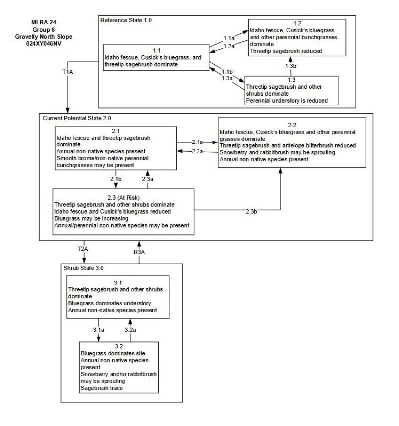
Figure 1. State and Transition Model 2021
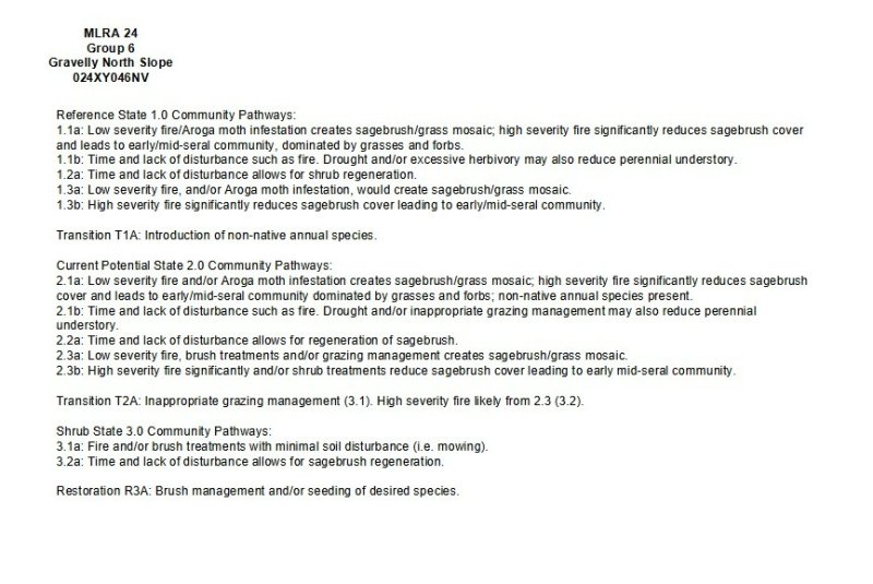
Figure 2. STM Narrative 2021
More interactive model formats are also available.
View Interactive Models
More interactive model formats are also available.
View Interactive Models
Click on state and transition labels to scroll to the respective text
Ecosystem states
State 1 submodel, plant communities
State 2 submodel, plant communities
State 3 submodel, plant communities
State 1
Reference State
The Reference State is a representative of the natural range of variability under pristine conditions. The reference state has three general community phases: a shrub-grass dominant phase, a perennial grass dominant phase and a shrub dominant phase. State dynamics are maintained by interactions between climatic patterns and disturbance regimes. Negative feedbacks enhance ecosystem resilience and contribute to the stability of the state. These include the presence of all structural and functional groups, low fine fuel loads, and retention of organic matter and nutrients. Plant community phase changes are primarily driven by fire, periodic drought and/or insect or disease attack.
Community 1.1
Reference Plant Community
The reference plant community is dominated by Idaho fescue, Cusick's bluegrass, bluebunch wheatgrass, and threetip sagebrush. Warmer exposures will normally express a higher percentage of bluebunch wheatgrass while cooler slopes support a high component of Idaho fescue. Potential vegetative composition is about 65% grasses, 10% forbs and 25% shrubs. Approximate ground cover (basal and crown) is 35 to 55 percent.
Figure 3. Annual production by plant type (representative values) or group (midpoint values)
Table 5. Annual production by plant type
| Plant type | Low (kg/hectare) |
Representative value (kg/hectare) |
High (kg/hectare) |
|---|---|---|---|
| Grass/Grasslike | 437 | 656 | 801 |
| Shrub/Vine | 168 | 252 | 308 |
| Forb | 67 | 101 | 123 |
| Total | 672 | 1009 | 1232 |
Community 1.2
Community Phase 1.2
This community phase is characteristic of a post-disturbance, early seral community phase. Idaho fescue, bluebunch wheatgrass and other perennial grasses dominate. Douglas rabbitbrush, mountain snowberry and Utah serviceberry may be sprouting. Big sagebrush is killed by fire, therefore decreasing within the burned community. Depending on fire severity or intensity of Aroga moth infestations, patches of intact sagebrush may remain. Perennial forbs may increase post-fire but will likely return to pre-burn levels within a few years.
Community 1.3
Community Phase 1.3
Mountain big sagebrush increases in the absence of disturbance. Decadent sagebrush dominates the overstory and the deep-rooted perennial bunchgrasses in the understory are reduced either from competition with shrubs and/or from herbivory. Sandberg bluegrass and/or squirreltail will likely increase in the understory and may be the dominant grass on the site.
Pathway 1.1a
Community 1.1 to 1.2
Fire will decrease or eliminate the overstory of sagebrush and allow for the perennial bunchgrasses to dominate the site. Fires will typically be low severity resulting in a mosaic pattern due to low fuel loads. A fire following an unusually wet spring or a change in management may be more severe and reduce sagebrush cover to trace amounts. A severe infestation of Aroga moth could also cause a large decrease in sagebrush within the community, giving a competitive advantage to the perennial grasses and forbs.
Pathway 1.1b
Community 1.1 to 1.3
Time and lack of disturbance such as fire allows for sagebrush to increase and become decadent. Long-term drought, herbivory, or combinations of these will cause a decline in perennial bunchgrasses and fine fuels leading to a reduced fire frequency allowing big sagebrush to dominate the site.
Pathway 1.2a
Community 1.2 to 1.1
Time and lack of disturbance will allow the mountain big sagebrush to recover/increase.
Pathway 1.3a
Community 1.3 to 1.1
A low severity fire, Aroga moth or combinations will reduce the sagebrush overstory and create a sagebrush/grass mosaic with sagebrush and perennial bunchgrasses codominant.
Pathway 1.3b
Community 1.3 to 1.2
Fire will decrease or eliminate the overstory of sagebrush and allow for the perennial bunchgrasses to dominate the site. Fires will typically be low severity due to low fine fuel loads. A fire following an unusually wet spring or a change in management may be more severe and reduce sagebrush cover to trace amounts. A severe infestation of Aroga moth could also cause a large decrease in sagebrush within the community, giving a competitive advantage to the perennial grasses and forbs.
State 2
Current Potential State
This state is similar to the Reference State 1.0 with three similar community phases and a forth community phase of increased annual non-native species. Ecological function has not changed, however the resiliency of the state has been reduced by the presence of invasive weeds. Non-natives may increase in abundance but will not become dominant within this State. These non-natives can be highly flammable, and can promote fire where historically fire had been infrequent. Negative feedbacks enhance ecosystem resilience and contribute to the stability of the state. These include the presence of all structural and functional groups, low fine fuel loads and retention of organic matter and nutrients. Positive feedbacks decrease ecosystem resilience and stability of the state. These include the non-natives’ high seed output, persistent seed bank, rapid growth rate, ability to cross pollinate and adaptations for seed dispersal.
Community 2.1
Community Phase 2.1
This community phase is similar to the Reference State Community Phase 1.1, with the presence of non-native species in trace amounts. The plant community is dominated by Idaho fescue, bluebunch wheatgrass and basin wildrye. Mountain big sagebrush is the dominant shrub. Smooth brome or other perennial non-native bunchgrasses may be present. Cheatgrass is the species most likely to invade.
Community 2.2
Community Phase 2.2
This community phase is characteristic of a post-disturbance, early seral community phase where non-native species are present. Idaho fescue, bluebunch wheatgrass and other perennial grasses dominate. Douglas rabbitbrush, mountain snowberry, desert peach and Utah serviceberry may be resprouting. Depending on fire severity or intensity of Aroga moth infestations, patches of intact sagebrush may remain. Perennial forbs may increase post-fire but will likely return to pre-burn levels within a few years. Annual non-native species are stable or increasing within the community.
Community 2.3
Community Phase 2.3 (At Risk)
Mountain big sagebrush, rabbitbrush and other shrubs increase, Idaho fescue and bluebunch wheatgrass decrease. Sandberg bluegrass may be increasing. Cheatgrass and other non-native species are stable to increasing. Juniper and pinyon may be present as a result of encroachment from neighboring sites, and lack of disturbance.
Pathway 2.1a
Community 2.1 to 2.2
Fire will decrease or eliminate the overstory of sagebrush and allow for the perennial bunchgrasses to dominate the site. Fires will typically be small and patchy due to low fuel loads. A fire following an unusually wet spring or a change in management may be more severe and reduce sagebrush cover to trace amounts. A severe infestation of Aroga moth could also cause a large decrease in sagebrush within the community, giving a competitive advantage to the perennial grasses and forbs.
Pathway 2.1b
Community 2.1 to 2.3
Time and lack of disturbance allows for sagebrush to increase and become decadent. Chronic drought will reduce fine fuels and lead to a reduced fire frequency allowing big sagebrush to dominate the site. Inappropriate grazing management will reduce the perennial bunchgrass understory; conversely Sandberg bluegrass may increase in the understory depending on grazing management. Excessive sheep grazing favors Sandberg bluegrass; however, where cattle are the dominant grazers, cheatgrass often increases.
Pathway 2.2a
Community 2.2 to 2.1
Time and lack of disturbance and/or grazing management that favors the establishment and growth of sagebrush allows the shrub component to recover. The establishment of big sagebrush may take many years.
Pathway 2.3a
Community 2.3 to 2.1
Grazing management that reduces shrubs will allow for the perennial bunchgrasses in the understory to increase. Heavy late-fall/winter grazing may cause mechanical damage to sagebrush thus promoting the perennial bunchgrass understory. Brush treatments with minimal soil disturbance will also decrease sagebrush and release the perennial understory. Annual non-native species are present and may increase in the community. A low severity fire would decrease the overstory of sagebrush and allow for the understory perennial grasses to increase. Due to low fuel loads in this State, fires will likely be small creating a mosaic pattern.
Pathway 2.3b
Community 2.3 to 2.2
Fire will decrease or eliminate the overstory of sagebrush and allow for the perennial bunchgrasses to dominate the site. Fires will typically be high intensity due to the dominance of sagebrush resulting in removal of the overstory shrub community. Annual non-native species respond well to fire and may increase post-burn. Brush treatment would reduce sagebrush overstory and allow for perennial bunchgrasses to increase.
State 3
Shrub State
This state has two community phases; a Wyoming big sagebrush dominated phase and a rabbitbrush dominated phase. This state is a product of many years of heavy grazing during time periods harmful to perennial bunchgrasses. Sandberg bluegrass will increase with a reduction in deep rooted perennial bunchgrass competition and become the dominant grass on this site. Sagebrush dominates the overstory and rabbitbrush may be a significant component. Sagebrush cover exceeds site concept and may be decadent, reflecting stand maturity and lack of seedling establishment due to competition with mature plants.
Community 3.1
Community Phase 3.1
This site has crossed a biotic threshold and site processes (soil hydrology, nutrient cycling, and energy capture) are being controlled by the shrub component of the plant community along with Sandberg bluegrass in the understory. Decadent big sagebrush and rabbitbrush dominate overstory. Deep-rooted perennial bunchgrasses may be present in trace amounts or absent from the community. Sandberg bluegrass and annual non-native species increase, and the amount of bare ground increases. Utah juniper and singleleaf pinyon may be present as a result of encroachment from neighboring sites and lack of natural fire.
Community 3.2
Community Phase 3.2
Bluegrass dominates the site; annual non-native species may be present but are not dominant. Trace amounts of sagebrush, snowberry and/or rabbitbrush may be present.
Pathway 3.1a
Community 3.1 to 3.2
Fire, heavy fall grazing causing mechanical damage to shrubs, and/or brush treatments with minimal soil disturbance, will greatly reduce the overstory shrubs to trace amounts and allow for Sandberg bluegrass to dominate the site.
Pathway 3.2a
Community 3.2 to 3.1
Absence of disturbance over time will allow for the sagebrush and other shrubs to recover. The regeneration of big sagebrush may take many years.
Transition T1A
State 1 to 2
Introduction of non-native annual species
Transition A
State 1 to 2
Introduction of non-native annual species
Transition T2A
State 2 to 3
Trigger: To Community Phase 3.1: Inappropriate grazing will decrease or eliminate deep rooted perennial bunchgrasses, increase Sandberg bluegrass and muttongrass and favor shrub growth and establishment. To Community Phase 3.2: Severe fire in community phase 2.3 will remove sagebrush overstory, decrease perennial bunchgrasses and enhance Sandberg bluegrass and muttongrass. Annual non-native species will increase. Slow variables: Long term decrease in deep-rooted perennial grass density resulting in decreased organic matter inputs and reduced soil water. Threshold: Loss of deep-rooted perennial bunchgrasses changes nutrient cycling, nutrient redistribution, and reduces soil organic matter.
Restoration pathway R3A
State 3 to 2
Brush management with minimal soil disturbance/seeding of desired species.
Additional community tables
Table 6. Community 1.1 plant community composition
| Group | Common name | Symbol | Scientific name | Annual production (kg/hectare) | Foliar cover (%) | |
|---|---|---|---|---|---|---|
|
Grass/Grasslike
|
||||||
| 1 | Primary Perennial Grasses | 424–888 | ||||
| Idaho fescue | FEID | Festuca idahoensis | 303–504 | – | ||
| Cusick's bluegrass | POCU3 | Poa cusickii | 101–303 | – | ||
| bluebunch wheatgrass | PSSPS | Pseudoroegneria spicata ssp. spicata | 20–81 | – | ||
| 2 | Primary Perennial Grasses | 50–151 | ||||
| Thurber's needlegrass | ACTH7 | Achnatherum thurberianum | 6–30 | – | ||
| squirreltail | ELEL5 | Elymus elymoides | 6–30 | – | ||
| basin wildrye | LECI4 | Leymus cinereus | 6–30 | – | ||
| Sandberg bluegrass | POSE | Poa secunda | 6–30 | – | ||
|
Forb
|
||||||
| 3 | Primary Perennial Forbs | 20–50 | ||||
| tapertip hawksbeard | CRAC2 | Crepis acuminata | 20–50 | – | ||
| 4 | Secondary Perennial Forbs | 50–101 | ||||
| aster | ASTER | Aster | 6–50 | – | ||
| milkvetch | ASTRA | Astragalus | 6–50 | – | ||
| arrowleaf balsamroot | BASA3 | Balsamorhiza sagittata | 6–50 | – | ||
| buckwheat | ERIOG | Eriogonum | 6–50 | – | ||
| lupine | LUPIN | Lupinus | 6–50 | – | ||
| phlox | PHLOX | Phlox | 6–50 | – | ||
|
Shrub/Vine
|
||||||
| 5 | Primary Shrubs | 151–252 | ||||
| threetip sagebrush | ARTR4 | Artemisia tripartita | 151–252 | – | ||
| 6 | Secondary Shrubs | 20–101 | ||||
| Utah serviceberry | AMUT | Amelanchier utahensis | 10–30 | – | ||
| mountain big sagebrush | ARTRV | Artemisia tridentata ssp. vaseyana | 10–30 | – | ||
| yellow rabbitbrush | CHVI8 | Chrysothamnus viscidiflorus | 10–30 | – | ||
| currant | RIBES | Ribes | 10–30 | – | ||
| snowberry | SYMPH | Symphoricarpos | 10–30 | – | ||
Interpretations
Animal community
Livestock Interpretations:
This site has limited value for livestock grazing, due to steep slopes. Grazing management should be keyed to dominant grasses and palatable shrubs production. Idaho fescue provides important forage for many types of domestic livestock. The foliage cures well and is preferred by livestock in late fall and winter. Cusick's bluegrass makes up only a small proportion of the biomass of the sagebrush communities in which it lives, but it is often taken preferentially by cattle, especially early in the season. Bluebunch wheatgrass is considered one of the most important forage grass species on western rangelands for livestock. Although bluebunch wheatgrass can be a crucial source of forage, it is not necessarily the most highly preferred species. Threetip sagebrush may provide some browse for domestic sheep but its value to cattle appears limited. It is not used by cattle in Nevada.
Stocking rates vary over time depending upon season of use, climate variations, site, and previous and current management goals. A safe starting stocking rate is an estimated stocking rate that is fine tuned by the client by adaptive management through the year and from year to year.
Wildlife Interpretations:
Idaho fescue provides important forage for several wildlife species. It is reported to be good forage for pronghorn, and deer in ranges of northern Nevada. Deer, elk, and mountain goat also use Cusick's bluegrass early in the season. The value of Cusick's bluegrass as cover for small animals has been rated as poor to fair. Bluebunch wheatgrass is considered one of the most important forage grass species on western rangelands for wildlife. Bluebunch wheatgrass does not generally provide sufficient cover for ungulates, however, mule deer are frequently found in bluebunch-dominated grasslands. Threetip sagebrush is not a preferred browse for most wild ungulates. Threetip sagebrush is used to some extent by mule deer in both summer and winter. Elk do not generally feed on threetip sagebrush. Sagebrush-grassland communities provide critical sage-grouse breeding and nesting habitats. Sagebrush is a crucial component of their diet year-round, and sage-grouse select sagebrush almost exclusively for cover.
Hydrological functions
Runoff is high. Permeability is moderate. Hydrologic soil group is B. Rills are none to rare. Rock fragments armor the soil surface. Water flow patterns are none to rare. Rock fragments armor the soil surface. Pedestals are none to rare. Occurrence is usually limited to areas of water flow patterns. Frost heaving of shallow rooted plants should not be considered a "normal" condition. Gullies are none. Perennial herbaceous plants (i.e., Idaho fescue) slow runoff and increase infiltration. Shrub canopy and associated litter break raindrop impact and provide opportunity for snow catch and accumulation on site.
Recreational uses
Aesthetic value is derived from the diverse floral and faunal composition and the colorful flowering of wild flowers and shrubs during the spring and early summer. This site offers rewarding opportunities to photographers and for nature study. This site is used for hiking and has potential for upland and big game hunting.
Supporting information
Inventory data references
NASIS soil component data.
Type locality
| Location 1: Humboldt County, NV | |
|---|---|
| Township/Range/Section | T36N R37E S11 |
| UTM zone | N |
| UTM northing | 4540194 |
| UTM easting | 434136 |
| Latitude | 41° 0′ 37″ |
| Longitude | 117° 45′ 59″ |
| General legal description | SE¼ North-facing sideslope, approximately ¼ mile below the top of Winnemucca Mountain, Humboldt County, Nevada. |
Other references
Fire Effects Information System (Online; http://www.fs.fed.us/database/feis/plants/).
USDA-NRCS Plants Database (Online; http://www.plants.usda.gov).
Akinsoji, A. 1988. Postfire vegetation dynamics in a sagebrush steppe in southeastern Idaho, USA. Vegetatio 78:151-155.
Anderson, E.W. and R.J. Scherzinger. 1975. Improving quality of winter forage for elk by cattle grazing. Journal of Range Management 28(2):120-125.
Barrington, M., S. Bunting, and G. Wright. 1988. A fire management plan for Craters of the Moon National Monument. Cooperative Agreement CA-9000-8-0005. Moscow, ID: University of Idaho, Range Resources Department. 52 p. Draft.
Bates, J. D., T. Svejcar, R. F. Miller, and R. A. Angell. 2006. The effects of precipitation timing on sagebrush steppe vegetation. Journal of Arid Environments 64:670-697.
Beetle, Alan A. 1962. Range survey in Teton County, Wyoming: Part 2. Utilization and condition classes. Bull. 400. Laramie, WY: University of Wyoming, Agricultural Experiment Station. 38 p.
Bentz, B., D. Alston, and T. Evans. 2008. Great Basin Insect Outbreaks. In: J. Chambers, N. Devoe, A. Evenden [eds]. Collaborative Management and Research in the Great Basin -- Examining the issues and developing a framework for action Gen. Tech. Rep. RMRS-GTR-204. U.S. Department of Agriculture, Forest Service, Rocky Mountain Research Station, Fort Collins, CO. p. 45-48
Blaisdell, J.P. 1953. Ecological effects of planned burning of sagebrush-grass range on the Upper Snake River Plains. Tech. Bull. 1975. Washington, DC: U.S. Department of Agriculture. 39 p.
Blaisdell, J.P. R.B. Murray, and E.D. McArthur. 1982. Managing Intermountain rangelands--sagebrush-grass ranges. Gen. Tech. Rep. INT-134. Ogden, UT: U.S. Department of Agriculture, Forest Service, Intermountain Forest and Range Experiment Station. 41 p.
Blaisdell, J.P. and J.F. Pechanec. 1949. Effects of herbage removal at various dates on vigor of bluebunch wheatgrass and arrowleaf balsamroot. Ecology 30(3):298-305.
Britton, C.M., G.R. McPherson and F.A. Sneva. 1990. Effects of burning and clipping on five bunchgrasses in eastern Oregon. The Great Basin Naturalist 50(2):115-120.
Brunner, James R. 1972. Observations on Artemisia in Nevada. Journal of Range Management. 25: 205-298.
Bunting, S.C., B.M. Kilgore, and C.L. Bushey. 1987. Guidelines for prescribed burning sagebrush-grass rangelands in the northern Great Basin. Gen. Tech. Rep. INT-231. Ogden, UT: U.S. Department of Agriculture, Forest Service, Intermountain Research Station. 33 p.
Burkhardt, J.W. and E.W. Tisdale. 1969. Nature and successional status of western juniper vegetation in Idaho. Journal of Range Management 22(4):264-270.
Busso, C. A. and J. H. Richards. 1995. Drought and clipping effects on tiller demography andgrowth of two tussock grasses in Utah. Journal of Arid Environments 29:239-251.
Caudle, D., J. DiBenedetto, M. Karl, H. Sanchez, and C. Talbot. 2013. Interagency ecological site handbook for rangelands. Available at: http://jornada.nmsu.edu/sites/jornada.nmsu.edu/files/InteragencyEcolSiteHandbook.pdf. Accessed 4 October 2013.
Chambers, J., B. Bradley, C. Brown, C. D’Antonio, M. Germino, J. Grace, S. Hardegree, R. Miller, and D. Pyke. 2013. Resilience to Stress and Disturbance, and Resistance to Bromus tectorum L. Invasion in Cold Desert Shrublands of Western North America. Ecosystems 17:1-16.
Chambers, J. C., B. A. Roundy, R. R. Blank, S. E. Meyer, and A. Whittaker. 2007. What makes great basin sagebrush ecosystems invasible by Bromus tectorum? Ecological Monographs 77:117-145.
Clark, D.L., T.W. Weaver, and D.G. Despain. 1994. Seedbanks under climax Rocky Mountain vegetation and the effects of fire on them. In: Despain, D.G. (ed.). Plants and their environments: proceedings of the 1st biennial scientific conference on the Greater Yellowstone Ecosystem; 1991 September 16-17; Yellowstone National Park. Tech. Rep. NPS/NRYELL/NRTR-93/XX.
212
Denver, CO: U.S. Department of the Interior, National Park Service, Rocky Mountain Region, Yellowstone National Park: Pgs 315-316.
Comstock, J. P. and J. R. Ehleringer. 1992. Plant adaptation in the Great Basin and Colorado plateau. Western North American Naturalist 52:195-215.
Conrad, C.E. and C.E. Poulton. 1966. Effect of a wildfire on Idaho fescue and bluebunch wheatgrass. Journal of Range Management 19(3):138-141.
Dobrowolski, J. P., M. M. Caldwell, and J. H. Richards. 1990. Basin hydrology and plant root systems. In: C. B. Osmand, L. F. Pitelka, G. M. Hildy [eds]. Plant biology of the Basin and range. Ecological Studies. 80: 243-292
Eckert, R.E., Jr., and J.S. Spencer. 1986. Vegetation response on allotments grazed under rest-rotation management. Journal of Range Management 39(2):166-174.
Eckert, R.E., Jr., and J.S. Spencer. 1987. Growth and reproduction of grasses heavily grazed under rest-rotation management. Journal of Range Management 40(2):156-159.
Furniss, M.M. and W.F. Barr. 1975. Insects affecting important native shrubs of the northwestern United States. US Intermountain Forest and Range Experiment Station. USDA Forest Service General Technical Report INT INT-19.
Gaffney, W.S. 1941. The effects of winter elk browsing, south fork of the Flathead River, Montana. Journal of Wildlife Management 5(4):427-453.
Ganskopp, D. 1988. Defoliation of Thurber needlegrass: herbage and root responses. Journal of Range Management 41(6):472-476.
Ganskopp, D., L. Aguilera, and M. Vavra. 2007. Livestock forage conditioning among six northern Great Basin grasses. Rangeland Ecology and Management 60:71-78.
Houston, D.B. 1973. Wildfires in northern Yellowstone National Park. Ecology 54(5):1111-1117.
Hurd, R.M. 1961. Grassland vegetation in the Big Horn Mountains, Wyoming. Ecology 42(3):459-467.
Johnson, C.G., Jr., R.R. Clausnitzer, P.J. Mehringer, and C.D. Oliver. 1994. Biotic and abiotic processes of Eastside ecosystems: the effects of management on plant and community ecology and on stand and landscape vegetation dynamics. Gen. Tech. Rep. PNW-GTR-322. Portland, OR: U.S. Department of Agriculture, Forest Service, Pacific Northwest Research Station. 66 p.
Koniak, S. 1985. Succession in pinyon-juniper woodlands following wildfire in the Great Basin. The Great Basin Naturalist 45(3):556-566.
Krall, J.L., J.R. Stroh, C.S. Cooper, and S.R. Chapman. 1971. Effect of time and extent of harvesting basin wildrye. Journal of Range Management 24(6):414-418.
Kuntz, D.E. 1982. Plant response following spring burning in an Artemisia tridentata subsp. vaseyana/Festuca idahoensis habitat type. Moscow, ID: University of Idaho. 73 p. Thesis.
Laycock, W.A. 1967. How heavy grazing and protection affect sagebrush-grass ranges. Journal of Range Management 20:206-213.
Leege, T. A. and W. O. Hickey. 1971. Sprouting of northern Idaho shrubs after prescribed burning. The Journal of Wildlife Management:508-515.
McArthur, E. Durant; Stevens, Richard 2004. Chapter 21. Composite shrubs. In: Monsen, Stephen B.; Stevens, Richard; Shaw, Nancy L., comps. Restoring western ranges and wildlands, vol. 2. Gen. Tech. Rep. RMRS-GTR-136-vol-2. Fort Collins, CO: U.S. Department of Agriculture, Forest Service, Rocky Mountain Research Station. p. 493-538
Miller, R.F., T.J. Svejcar, and J.A. Rose. 2000. Impacts of western juniper on plant community composition and structure. Journal of Range Management 53(6):574-585.
Merrill, E. H., H. Mayland, and J. Peek. 1982. Shrub responses after fire in an Idaho ponderosa pine community. The Journal of Wildlife Management 46:496-502.
Mueggler, W. F. 1975. Rate and Pattern of Vigor Recovery in Idaho Fescue and Bluebunch Wheatgrass. Journal of Range Management 28:198-204.
213
Neuenschwander, L.F. 1980. Broadcast burning of sagebrush in the winter. Journal of Range Management (33)3:233-236.
Noste, N.V. and C.L. Bushey. 1987. Fire response of shrubs of dry forest habitat types in Montana and Idaho. Gen. Tech. Rep. INT-239. Ogden, UT: U.S. Department of Agriculture, Forest Service, Intermountain Research Station. 22 p.
Noy-Meir, I. 1973. Desert ecosystems: environment and producers. Annual Review of Ecology and Systematics 4:25-51.
Richards, J. H. and M. M. Caldwell. 1987. Hydraulic lift: Substantial nocturnal water transport between soil layers by Artemisia tridentata roots. Oecologia 73:486-489.
Robberecht, R. and G.E. Defosse. 1995. The relative sensitivity of two bunchgrass species to fire. International Journal of Wildland Fire 5(3):127-134.
Smith, M.A. and F. Busby. 1981. Prescribed burning: effective control of sagebrush in Wyoming. RJ-165. Laramie, WY: University of Wyoming, Agricultural Experiment Station. 12 p.
Uresk, D. W., J. F. Cline, and W. H. Rickard. 1976. Impact of wildfire on three perennial grasses in south-central Washington. Journal of Range Management 29:309-310.
Whisenant, S. G. 1990. Changing fire frequencies on Idaho’s Snake River Plains: ecological and management implications. McArthur, E. Durant; Romney, Evan M.; Smith, Stanley D:5-7.
Wright, H. A. 1971. Why Squirreltail Is More Tolerant to Burning than Needle-and-Thread. Journal of Range Management 24:277-284.
Wright, H. A. 1985. Effects of fire on grasses and forbs in sagebrush-grass communities. In: K.E. Sanders [ed.] Rangeland Fire Effects; A Symposium: proceedings of a symposium sponsored by Bureau of Land Management and University of Idaho at Boise Idaho. Boise, ID, USDI-BLM. P. 12-21
Wright, H.A., L.F. Neuenschwander, and C.M. Britton. 1979. The role and use of fire in sagebrush-grass and pinyon-juniper plant communities: A state-of-the-art review. Gen. Tech. Rep. INT-58. Ogden, UT: U.S. Department of Agriculture, Forest Service, Intermountain Forest and Range Experiment Station. 48 p.
Young, R.P. 1983. Fire as a vegetation management tool in rangelands of the Intermountain Region. In: Monsen, S.B. and N. Shaw (compilers). Managing Intermountain rangelands--improvement of range and wildlife habitats: Proceedings; 1981 September 15-17; Twin Falls, ID; 1982 June 22-24; Elko, NV. Gen. Tech. Rep. INT-157. Ogden, UT: U.S. Department of Agriculture, Forest Service, Intermountain Forest and Range Experiment Station: Pgs 18-31.
Zschaechner, G.A. 1985. Studying rangeland fire effects: a case study in Nevada. In: Sanders, K. and J. Durham (eds). Rangeland fire effects. Proceedings of the symposium. 1984 November 27-29; Boise, ID. Boise, ID. U.S. Department of the Interior, Bureau of Land Management, Idaho State Office. Pgs 66-84.
Contributors
GKB
TK Stringham
Approval
Kendra Moseley, 3/06/2025
Rangeland health reference sheet
Interpreting Indicators of Rangeland Health is a qualitative assessment protocol used to determine ecosystem condition based on benchmark characteristics described in the Reference Sheet. A suite of 17 (or more) indicators are typically considered in an assessment. The ecological site(s) representative of an assessment location must be known prior to applying the protocol and must be verified based on soils and climate. Current plant community cannot be used to identify the ecological site.
| Author(s)/participant(s) | Patti Novak-Echenique |
|---|---|
| Contact for lead author | State Rangeland Management Specialist |
| Date | 03/19/2010 |
| Approved by | Kendra Moseley |
| Approval date | |
| Composition (Indicators 10 and 12) based on | Annual Production |
Indicators
-
Number and extent of rills:
Rills are none to rare. Rock fragments armor the soil surface. -
Presence of water flow patterns:
Water flow patterns are none to rare. Rock fragments armor the soil surface. -
Number and height of erosional pedestals or terracettes:
Pedestals are none to rare. Occurrence is usually limited to areas of water flow patterns. Frost heaving of shallow rooted plants should not be considered a "normal" condition. -
Bare ground from Ecological Site Description or other studies (rock, litter, lichen, moss, plant canopy are not bare ground):
Bare ground is 10-20%. -
Number of gullies and erosion associated with gullies:
Gullies are none. -
Extent of wind scoured, blowouts and/or depositional areas:
None -
Amount of litter movement (describe size and distance expected to travel):
Fine litter (foliage from grasses and annual & perennial forbs) expected to move distance of slope length during intense summer convection storms or rapid snowmelt events. Persistent litter (large woody material) will remain in place except during catastrophic events. -
Soil surface (top few mm) resistance to erosion (stability values are averages - most sites will show a range of values):
Soil stability values should be 3 to 6 on most soil textures found on this site. Areas of this site occurring on soils that have a physical crust will probably have stability values less than 3. (To be field tested.) -
Soil surface structure and SOM content (include type of structure and A-horizon color and thickness):
Surface structure is typically subangular blocky. Soil surface colors are dark and soils are typified by a mollic epipedon. Organic matter of the surface 2 to 3 inches is typically 1 to 3 percent dropping off quickly below. Organic matter content can be more or less depending on micro-topography. -
Effect of community phase composition (relative proportion of different functional groups) and spatial distribution on infiltration and runoff:
Perennial herbaceous plants (i.e., Idaho fescue) slow runoff and increase infiltration. Shrub canopy and associated litter break raindrop impact and provide opportunity for snow catch and accumulation on site. -
Presence and thickness of compaction layer (usually none; describe soil profile features which may be mistaken for compaction on this site):
Compacted layers are not typical. Subangular blocky or massive sub-surface horizons are not to be interpreted as compacted layers. -
Functional/Structural Groups (list in order of descending dominance by above-ground annual-production or live foliar cover using symbols: >>, >, = to indicate much greater than, greater than, and equal to):
Dominant:
Reference Plant Community: Deep-rooted, cool season, perennial bunchgrassesSub-dominant:
Tall shrubs (i.e., threetip sagebrush) > shallow-rooted, cool season, perennial bunchgrasses > associated shrubs > deep-rooted, cool season, perennial forbs > fibrous, shallow-rooted, cool season, perennial and annual forbsOther:
Additional:
-
Amount of plant mortality and decadence (include which functional groups are expected to show mortality or decadence):
Dead branches within individual shrubs common and standing dead shrub canopy material may be as much as 25% of total woody canopy; some of the mature bunchgrasses (<20%) have dead centers. -
Average percent litter cover (%) and depth ( in):
Within plant interspaces (± 20%) and depth of litter is <½ inch. -
Expected annual annual-production (this is TOTAL above-ground annual-production, not just forage annual-production):
For normal or average growing season (end of May) ± 900 lbs/ac; Spring moisture significantly affects total production. -
Potential invasive (including noxious) species (native and non-native). List species which BOTH characterize degraded states and have the potential to become a dominant or co-dominant species on the ecological site if their future establishment and growth is not actively controlled by management interventions. Species that become dominant for only one to several years (e.g., short-term response to drought or wildfire) are not invasive plants. Note that unlike other indicators, we are describing what is NOT expected in the reference state for the ecological site:
Increasers include Douglas rabbitbrush, singleleaf pinyon, and Utah juniper. Invaders include halogeton, Russian thistle, bassia, annual mustards, and cheatgrass. -
Perennial plant reproductive capability:
All functional groups should reproduce in average (or normal) and above average growing season years.
Print Options
Sections
Font
Other
The Ecosystem Dynamics Interpretive Tool is an information system framework developed by the USDA-ARS Jornada Experimental Range, USDA Natural Resources Conservation Service, and New Mexico State University.
Click on box and path labels to scroll to the respective text.