Provisional. A provisional ecological site description has undergone quality control and quality assurance review. It contains a working state and transition model and enough information to identify the ecological site.
MLRA notes
Major Land Resource Area (MLRA): 026X–Carson Basin and Mountains
The area lies within western Nevada and eastern California, with about 69 percent being within Nevada, and 31 percent being within California. Almost all this area is in the Great Basin Section of the Basin and Range Province of the Intermontane Plateaus. Isolated north-south trending mountain ranges are separated by aggraded desert plains. The mountains are uplifted fault blocks with steep side slopes. Most of the valleys are drained by three major rivers flowing east across this MLRA. A narrow strip along the western border of the area is in the Sierra Nevada Section of the Cascade-Sierra Mountains Province of the Pacific Mountain System. The Sierra Nevada Mountains are primarily a large fault block that has been uplifted with a dominant tilt to the west. This structure leaves an impressive wall of mountains directly west of this area. This helps create a rain shadow affect to MLRA 26. Parts of this eastern face, but mostly just the foothills, mark the western boundary of this area. Elevations range from about 3,806 feet (1,160 meters) on the west shore of Pyramid Lake to 11,653 feet (3,552 meters) on the summit of Mount Patterson in the Sweetwater Mountains.
Valley areas are dominantly composed of Quaternary alluvial deposits with Quaternary playa or alluvial flat deposits often occupying the lowest valley bottoms in the internally drained valleys, and river deposited alluvium being dominant in externally drained valleys. Hills and mountains are dominantly Tertiary andesitic flows, breccias, ash flow tuffs, rhyolite tuffs or granodioritic rocks. Quaternary basalt flows are present in lesser amounts, and Jurassic and Triassic limestone and shale, and Precambrian limestone and dolomite are also present in very limited amounts. Also of limited extent are glacial till deposits along the east flank of the Sierra Nevada Mountains, the result of alpine glaciation.
The average annual precipitation in this area is 5 to 36 inches (125 to 915 millimeters), increasing with elevation. Most of the rainfall occurs as high-intensity, convective storms in spring and autumn. Precipitation is mostly snow in winter. Summers are dry. The average annual temperature is 37 to 54 degrees F (3 to 12 degrees C). The freeze-free period averages 115 days and ranges from 40 to 195 days, decreasing in length with elevation.
The dominant soil orders in this MLRA are Aridisols and Mollisols. The soils in the area dominantly have a mesic soil temperature regime, an aridic or xeric soil moisture regime, and mixed or smectitic mineralogy. They generally are well drained, are clayey or loamy and commonly skeletal, and are very shallow to moderately deep.
This area supports shrub-grass vegetation characterized by big sagebrush. Low sagebrush and Lahontan sagebrush occur on some soils. Antelope bitterbrush, squirreltail, desert needlegrass, Thurber needlegrass, and Indian ricegrass are important associated plants. Green ephedra, Sandberg bluegrass, Anderson peachbrush, and several forb species also are common. Juniper-pinyon woodland is typical on mountain slopes. Jeffrey pine, lodgepole pine, white fir, and manzanita grow on the highest mountain slopes. Shadscale is the typical plant in the drier parts of the area. Sedges, rushes, and moisture-loving grasses grow on the wettest parts of the wet flood plains and terraces. Basin wildrye, alkali sacaton, saltgrass, buffaloberry, black greasewood, and rubber rabbitbrush grow on the drier sites that have a high concentration of salts.
Some of the major wildlife species in this area are mule deer, coyote, beaver, muskrat, jackrabbit, cottontail, raptors, pheasant, chukar, blue grouse, mountain quail, and mourning dove. The species of fish in the area include trout and catfish. The Lahontan cutthroat trout in the Truckee River is a threatened and endangered species.
LRU notes
The Semiarid Fans and Basins LRU includes basins, alluvial fans and adjacent hill slopes immediately east of the Sierra Nevada mountain range and are affected by its climate or have its granitic substrate. Elevations range from 1355 to 1920 meters and slopes range from 0 to 30 percent, with a median value of 6 percent. Frost free days range from 121 to 170.
Ecological site concept
The Dune 10-12 P.Z. site occurs on stabilized sand dunes formed on beach terraces and lower piedmont slopes at elevations of 4,500 to 5,600 feet and typical slopes of 4 to 30 percent. Soils are very deep, excessively drained, and coarse in texture. The dominant vegetation is bitterbrush (Purshia tridentata), big sagebrush (Artemisia tridentata), needle and thread grass (Hesperstipa comata), and Indian ricegrass (Achnatherum hymenoides).
The Dune 10-12 P.Z. site occurs on stabilized sand dunes formed on beach terraces and sand sheets on lower piedmont slopes. Slopes range from 4 to 30 percent. Elevations are 4500 to 5600 feet.
Table 2. Representative physiographic features
Landforms
(1) Dune
Elevation
4,500–5,600 ft
Slope
4–30%
Aspect
Aspect is not a significant factor
Climatic features
The climate associated with this site is arid, characterized by cool, moist winters and warm, dry summers. Average annual precipitation is 10 to 12 inches. Mean annual air temperature is 49 to 52 degrees F. The average growing season is about 100 to 120 days.
Nevada’s climate is predominantly arid, with large daily ranges of temperature, infrequent severe storms, heavy snowfall in the higher mountains, and great location variations with elevation. Three basic geographical factors largely influence Nevada’s climate: continentality, latitude, and elevation. Continentality is the most important factor. The strong continental effect is expressed in the form of both dryness and large temperature variations. Nevada lies on the eastern, lee side of the Sierra Nevada Range, a massive mountain barrier that markedly influences the climate of the State. The prevailing winds are from the west, and as the warm moist air from the Pacific Ocean ascend the western slopes of the Sierra Range, the air cools, condensation occurs and most of the moisture falls as precipitation. As the air descends the eastern slope, it is warmed by compression, and very little precipitation occurs. The effects of this mountain barrier are felt not only in the West but throughout the state, with the result that the lowlands of Nevada are largely desert or steppes. The temperature regime is also affected by the blocking of the inland-moving maritime air. Nevada sheltered from maritime winds, has a continental climate with well-developed seasons and the terrain responds quickly to changes in solar heating.
Nevada lies within the mid-latitude belt of prevailing westerly winds which occur most of the year. These winds bring frequent changes in weather during the late fall, winter and spring months, when most of the precipitation occurs. To the south of the mid-latitude westerlies, lies a zone of high pressure in subtropical latitudes, with a center over the Pacific Ocean. In the summer, this high-pressure belt shifts northward over the latitudes of Nevada, blocking storms from the ocean. The resulting weather is mostly clear and dry during the summer and early fall, with scattered thundershowers. The eastern portion of the state receives significant summer thunderstorms generated from monsoonal moisture pushed up from the Gulf of California, known as the North American monsoon. The monsoon system peaks in August and by October the monsoon high over the Western U.S. begins to weaken and the precipitation retreats southward towards the tropics (NOAA 2004).
Table 3. Representative climatic features
Frost-free period (characteristic range)
Freeze-free period (characteristic range)
Precipitation total (characteristic range)
10-12 in
Frost-free period (average)
110 days
Freeze-free period (average)
Precipitation total (average)
11 in
Bar
Line
Figure 1. Monthly average minimum and maximum temperature
Figure 2. Annual precipitation pattern
Figure 3. Annual average temperature pattern
Influencing water features
There are no influencing water features associated with this site.
Soil features
The soils are coarse textured, very deep, and excessively drained. The available water capacity is low and the surface layer is droughty. The high infiltration rate of the sand and the very deep profile are important factors in site development. Although the available water capacity for the 5 foot profile is low, the very deep soils retain most of the moisture received in a normal year allowing deep rooted plants to thrive. The soil warms in early spring causing an early on-set of plant growth resulting in a more efficient use of spring and early summer moisture. Soil series associated with this site include: Incy.
Table 4. Representative soil features
Parent material
(1) Eolian deposits
Surface texture
(1) Fine sand
Family particle size
(1) Sandy
Drainage class
Excessively drained
Permeability class
Very rapid
Soil depth
72–84 in
Surface fragment cover <=3"
6%
Surface fragment cover >3"
Not specified
Available water capacity (0-40in)
2–2.8 in
Calcium carbonate equivalent (0-40in)
Not specified
Electrical conductivity (0-40in)
Not specified
Sodium adsorption ratio (0-40in)
Not specified
Soil reaction (1:1 water) (0-40in)
6.6–7.3
Subsurface fragment volume <=3" (Depth not specified)
6%
Subsurface fragment volume >3" (Depth not specified)
Not specified
Ecological dynamics
As ecological condition declines, Anderson's peachbrush, basin big sagebrush, Wyoming big sagebrush, and rubber rabbitbrush become more dominant. Species most likely to invade this site are annuals.
Fire Ecology:
The mean fire return interval on a dune ecological site is variable and is similar to adjacent ecological sites. Season of burning and environmental conditions impact antelope bitterbrush ability to survive fire and sprout. Antelope bitterbrush is very susceptible to fire kill. It is considered a weak sprouter and is often killed by summer or fall fire. Antelope bitterbrush in some areas may sprout after light-severity spring fire. High fuel consumptions increase antelope bitterbrush mortality and therefore favors seedling establishment. Wyoming big sagebrush establishes after fire from a seedbank; from seed produced by remnant plants that escaped fire; and from plants adjacent to the burn that seed in. Big sagebrush is readily killed when aboveground plant parts are charred by fire. If sagebrush foliage is exposed to temperature above 195 degrees Fahrenheit for longer than 30 seconds, the plant dies. Prolific seed production from nearby unburned plants coupled with high germination rates enables seedlings to establish rapidly following fire. Desert peach sprouts from rhizomes and/or lignotubers following fire, and is said to "reach its greatest development" on burned sites. Postfire seedling establishment is rare. Desert peach is typically only top-killed by fire. Neither aboveground stem survival nor complete shrub kill is reported following fire. Green ephedra generally sprouts vigorously from the roots or woody root crown after fire and rapidly produces aboveground biomass from surviving meristematic tissue. Fires in spiny hopsage sites generally occur in late summer when plants are dormant, and sprouting generally does not occur until the following spring. Spiny hopsage is considered to be somewhat fire tolerant and often survives fires that kill sagebrush. Mature spiny hopsage generally sprout after being burned. Spiny hopsage is reported to be least susceptible to fire during summer dormancy. Needleandthread grass is top-killed by fire. It may be killed if the aboveground stems are completely consumed. Needleandthread grass sprouts from the caudex following fire, if heat has not been sufficient to kill underground parts. Recovery usually takes 2 to 10 years. Indian ricegrass can be killed by fire, depending on severity and season of burn. Indian ricegrass reestablishes on burned sites through seed dispersed from adjacent unburned areas. Desert needlegrass has persistent dead leaf bases, which make it susceptible to burning. Fire removes the accumulation; a rapid, cool fire will not burn deep into the root crown. Most perennial grasses have root crowns that can survive wildfire. Basin wildrye is top-killed by fire. Older basin wildrye plants with large proportions of dead material within the perennial crown can be expected to show higher mortality due to fire than younger plants having little debris. Basin wildrye is generally tolerant of fire but may be damaged by early season fire combined with dry soil conditions.
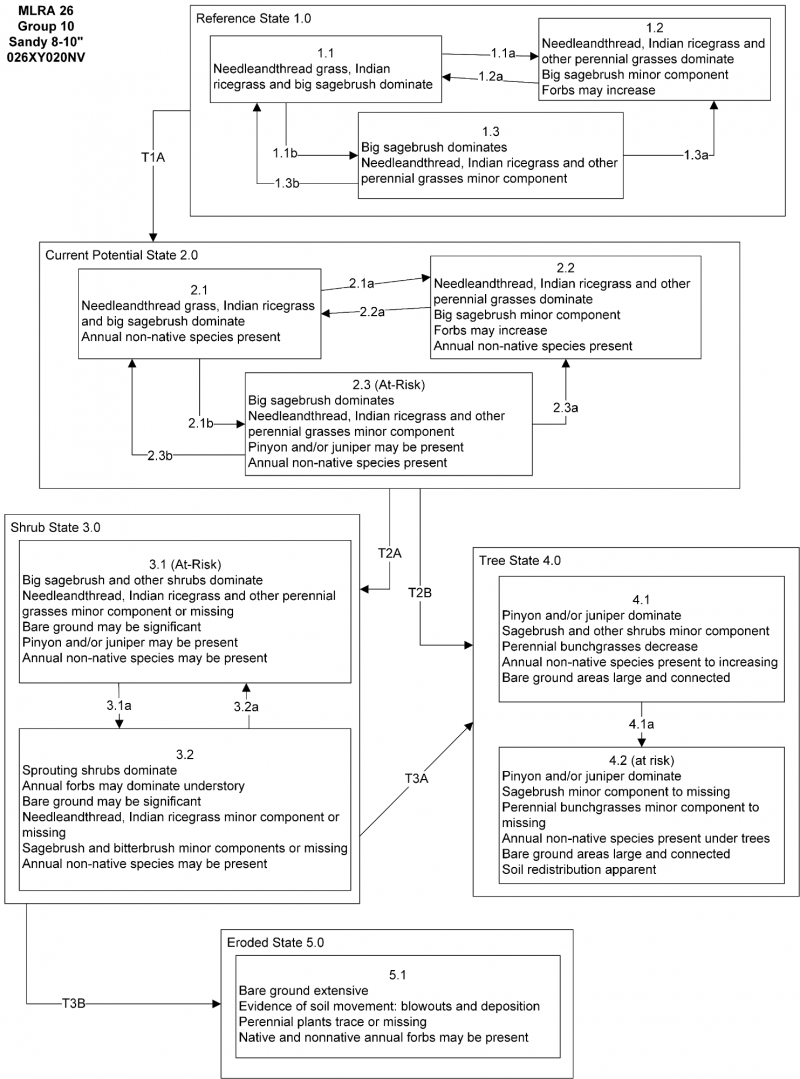
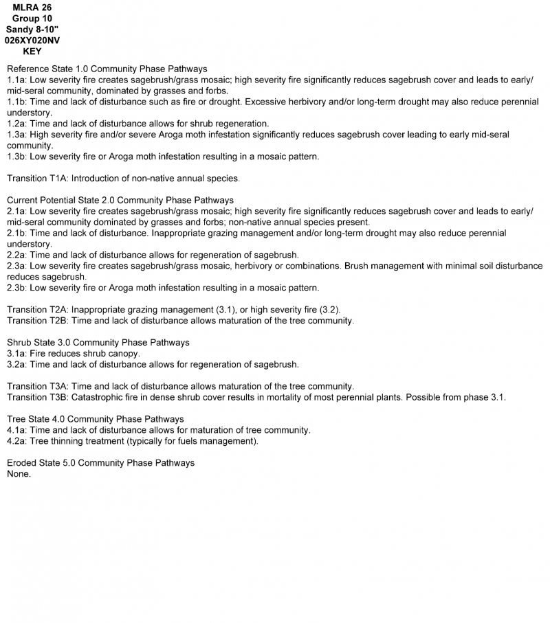
State and Transition Model Narrative Group 10
This is a text description of the states, phases, transitions, and community pathways possible in the State and Transition model for the MLRA 26 Disturbance Response Group 10. Other sites included in this group are: R026XY020NV, R026XY096NV, and R026XF005CA.
Reference State 1.0 Community Phase Pathways:
The Reference State 1.0 is a representation of the natural range of variability under pristine conditions. The reference state has three general community phases; a shrub-grass dominant phase, a perennial grass dominant phase and a shrub dominant phase. State dynamics are maintained by interactions between climatic patterns and disturbance regimes. Negative feedbacks enhance ecosystem resilience and contribute to the stability of the state. These include the presence of all structural and functional groups, low fine fuel loads, and retention of organic matter and nutrients. Plant community phase changes are primarily driven by fire, periodic drought, and/or insect or disease attack.
Community Phase 1.1:
This community is dominated by needle and thread grass, Indian ricegrass and big sagebrush. Fourwing saltbush, ephedra, and other shrubs are present. Desert needlegrass, basin wildrye, and a variety of perennial and annual forbs are also present in this phase.
Community Phase Pathway 1.1a, from phase 1.1 to 1.2:
Fire would decrease or eliminate the overstory of sagebrush and allow for the perennial bunchgrasses to dominate the site. Low severity fire creates sagebrush/grass mosaic. High severity fire significantly reduces sagebrush cover and leads to early/mid-seral community dominated by grasses and forbs. Release from drought may allow needle and thread and Indian ricegrass to increase in production.
Community Phase Pathway 1.1b, from phase 1.1 to 1.3:
Time and lack of disturbance such as fire or drought allows shrubs to become dominant. Excessive herbivory and/or long-term drought may also reduce perennial herbaceous understory.
Community Phase 1.2:
This community phase is characteristic of a post-disturbance, early seral community. Needle and thread, Indian ricegrass and other perennial grasses dominate. Big sagebrush is a minor component. Forbs and sprouting shrubs may increase.
Community Phase Pathway 1.2a, from phase 1.2 to 1.1:
Time and lack of disturbance allows sagebrush to reestablish.
Community Phase 1.3:
Big sagebrush increases in the absence of disturbance. Needle and thread, Indian ricegrass, and other perennial grasses may be a minor component.
Community Phase Pathway 1.3a, from phase 1.3 to 1.2:
Fire would decrease or eliminate the overstory of sagebrush and allow for the perennial bunchgrasses to dominate the site. Low severity fire creates sagebrush/grass mosaic. High severity fire significantly reduces sagebrush cover and leads to early/mid-seral community dominated by grasses and forbs. This pathway may also occur after a severe Aroga moth infestation that significantly reduces live sagebrush cover.
Community Phase Pathway 1.3b, from phase 1.3 to 1.1:
Aroga moth infestation reduces live sagebrush cover and allows grasses to increase in the understory. Release from drought may allow needle and thread and Indian ricegrass to increase in production.
T1A: Transition from Reference State 1.0 to Current Potential State 2.0:
Trigger: This transition is caused by the introduction of non-native annual weeds, such as cheatgrass, mustard (Descurainia or Sisymbrium spp.), and Russian thistle (Salsola tragus).
Slow variables: Over time the annual non-native plants will increase within the community, decreasing organic matter inputs from deep-rooted perennial bunchgrasses. This leads to reductions in soil water holding capacity.
Threshold: Any amount of introduced non-native species causes an immediate reduction in the resilience of the site. Annual non-native species cannot be easily removed from the system and have the potential to significantly alter disturbance regimes from their historic range of variation.
Current Potential State 2.0 Community Phase Pathways:
This state is similar to the Reference State 1.0. Ecological function has not changed, however the resiliency of the state has been reduced by the presence of invasive weeds. This state has the same three general community phases as the Reference State. Negative feedbacks enhance ecosystem resilience and contribute to the stability of the state. These include the presence of all structural and functional groups, low fine fuel loads and retention of organic matter and nutrients. Positive feedbacks reduce ecosystem resilience and stability of the state. These include the non-natives’ high seed output, persistent seed bank, rapid growth rate, ability to cross pollinate, and adaptations for seed dispersal. Additionally, the presence of highly flammable annual non-native species reduces State resilience because these species can promote fire where historically fire has been infrequent. This leads to positive feedbacks that further the degradation of the system.
Community Phase 2.1:
This community is dominated by needle and thread grass, Indian ricegrass and big sagebrush. Fourwing saltbush, ephedra, and other shrubs are present. Desert needlegrass, basin wildrye, and a variety of perennial and annual forbs are also present in this phase. Annual non-native species present.
Community Phase Pathway 2.1a, from phase 2.1 to 2.2:
Fire would decrease or eliminate the overstory of sagebrush and allow for the perennial bunchgrasses to dominate the site. Low severity fire creates sagebrush/grass mosaic. High severity fire significantly reduces sagebrush cover and leads to early/mid-seral community dominated by grasses and forbs; non-native annual species present.
Community Phase Pathway 2.1b, from phase 2.1 to 2.3:
Time, long-term drought, grazing management that favors shrubs or combinations of these would allow the sagebrush overstory to increase and dominate the site, causing a reduction in the perennial bunchgrasses.
Community Phase 2.2:
This community phase is characteristic of a post-disturbance, early seral community. Needle and thread, Indian ricegrass and other perennial grasses dominate. Big sagebrush is a minor component. Forbs and sprouting shrubs may increase. Annual non-native species present.
Community Phase Pathway 2.2a, from phase 2.2 to 2.1:
Absence of disturbance over time allows for the sagebrush to recover. This may be combined with grazing management that favors shrubs.
Community Phase 2.3 (At-Risk):
Big sagebrush dominates and the perennial grasses become a minor component. Pinyon and juniper may be present. Annual non-native species present.
Community Phase Pathway 2.3a, from phase 2.3 to 2.2:
Fire would decrease or eliminate the overstory of sagebrush and allow for the perennial bunchgrasses to dominate the site. Low severity fire creates sagebrush/grass mosaic. High severity fire significantly reduces sagebrush cover and leads to early/mid-seral community dominated by grasses and forbs. This pathway may also occur after a severe Aroga moth infestation that significantly reduces live sagebrush cover. Brush treatments with minimal soil disturbance will also decrease sagebrush and release the perennial understory. Annual non-native species are present and may increase in the community.
Community Phase Pathway 2.3b, from phase 2.3 to 2.1:
A change in grazing management that reduces shrubs will allow the perennial bunchgrasses in the understory to dominate. Heavy late-fall or winter grazing may cause mechanical damage and subsequent death to sagebrush, facilitating an increase in the herbaceous understory. Brush treatments with minimal soil disturbance will also decrease sagebrush and release the perennial understory. A low severity fire would decrease the overstory of sagebrush or leave patches of shrubs, and would allow the understory perennial grasses to dominate. This pathway may also occur after a severe Aroga moth infestation that significantly reduces live sagebrush cover. Annual non-native species are present and may increase in the community.
T2A: Transition from Current Potential State 2.0 to Shrub State 3.0:
Trigger: Inappropriate, long-term grazing of perennial bunchgrasses during the growing season would favor shrubs and initiate transition to Community Phase 3.1. Fire would cause a transition to Community Phase 3.2.
Slow variables: Long term decrease in deep-rooted perennial grass density resulting in a decrease in organic matter inputs and subsequent soil water decline.
Threshold: Loss of deep-rooted perennial bunchgrasses changes spatial and temporal nutrient cycling and nutrient redistribution, and reduces soil organic matter.
T2B: Transition from Current Potential State 2.0 to Tree State 4.0:
Trigger: Time and lack of disturbance or management action allows juniper and/or Pinion to dominate. This may be coupled with grazing management that favors tree establishment by reducing understory herbaceous competition for site resources Feedbacks and ecological processes: Trees increasingly dominate use of soil water, contributing to reductions in soil water availability to grasses and shrubs. Overtime, grasses and shrubs are outcompeted. Reduced herbaceous and shrub production slows soil organic matter inputs and increases soil erodibility through loss of cover and root structure.
Slow variables: Over time the abundance and size of trees will increase.
Threshold: Trees dominate ecological processes and number of shrub skeletons exceed number of live shrubs. Minimal recruitment of new shrub cohorts.
Shrub State 3.0 Community Phase Pathways:
This state has two community phases: a big sagebrush dominated phase and a sprouting shrub dominated phase. This state is a product of many years of heavy grazing during time periods harmful to perennial bunchgrasses. Shrubs dominate the plant community. If coming from phase 2.3, big sagebrush canopy cover is high and these plants may be decadent, reflecting stand maturity and lack of seedling establishment due to competition with mature plants. Typically, this state has little herbaceous understory and may be experiencing soil movement in the interspaces. The shrub overstory dominates site resources such that soil water, nutrient capture, nutrient cycling and soil organic matter are temporally and spatially redistributed.
Community Phase 3.1:
Big sagebrush and other shrubs dominate. Needle and thread, Indian ricegrass and other perennial grasses are only present in trace amounts, under shrubs, or may be missing entirely. Pinyon and/or juniper may be present. Annual non-native species may be present.
Community Phase Pathway 3.1a, from Phase 3.1 to 3.2:
Fire, heavy fall grazing that causes mechanical damage to shrubs, and/or brush treatments with minimal soil disturbance will greatly reduce the overstory shrubs to trace amounts and allow annual forbs and sprouting shrubs to dominate the site.
Community Phase 3.2:
Sprouting shrubs such as fourwing saltbush, spiny hopsage, ephedra, and desert peach dominate the site. Annual forbs may dominate the understory. Perennial grasses and sagebrush may be a minor component or missing entirely. Bitterbrush may be present. Bare ground may be significant. Annual non-native species may be present.
Community Phase Pathway 3.2a, from Phase 3.2 to 3.1:
Time and lack of disturbance allows the shrub component to recover. The establishment of sagebrush can take many years unless aided with restoration efforts.
T3A: Transition from Shrub State 3.0 to Tree State 4.0:
Trigger: Lack of fire allows trees to dominate site. This may be coupled with inappropriate grazing management that reduces fine fuels.
Slow variables: Increased establishment and cover of juniper trees, reduction in organic matter inputs.
Threshold: Trees overtop Wyoming big sagebrush and out-compete shrubs for water and sunlight. Shrub skeletons exceed live shrubs with minimal recruitment of new cohorts.
T3B: Transition from Shrub State 3.0 to Eroded State 5.0:
Trigger: High-intensity fire (from 3.1) kills all non-sprouting shrubs and many sprouting shrubs.
Slow variables: Increased dominance of sagebrush and/or bitterbrush creates extreme woody fuel conditions. Loss of the deep-rooted bunchgrass understory leaves few plants capable of regenerating post-fire, and eliminates the seed bank of these species.
Threshold: Changes in plant community composition and spatial variability of vegetation due to the loss of perennial bunchgrasses truncates energy capture and impacts nutrient cycling and distribution. Large, potentially decadent shrubs dominate the landscape with a closed canopy.
Tree State 4.0 Community Phase Pathway:
This state has two community phases that are characterized by the dominance of Utah juniper and/or singleleaf pinyon in the overstory. Wyoming big sagebrush and perennial bunchgrasses may still be present, but they are no longer controlling site resources. Soil moisture, soil nutrients, soil organic matter distribution and nutrient cycling have been spatially and temporally altered.
Community Phase 4.1:
Utah juniper and/or singleleaf pinyon dominate the overstory and site resources. Trees are actively growing with noticeable leader growth. Trace amounts of bunchgrasses may be found under tree canopies and in interspaces. Sagebrush is stressed and dying. Annual non-native species are present under tree canopies. Bare ground interspaces are large and connected.
Community Phase Pathway 4.1a, from phase 4.1 to 4.2:
Time and lack of disturbance or management action allows Utah juniper and/or singleleaf pinyon to mature further and dominate site resources.
Community Phase 4.2:
Utah juniper and/or singleleaf pinyon dominate the site and tree leader growth is minimal. Annual non-native species may be the dominant understory species and will typically be found under the tree canopies. Trace amounts of sagebrush may be present, however, dead shrub skeletons will be more numerous than live sagebrush. Bunchgrasses may or may not be present. Needle and thread or mat forming forbs may be present in trace amounts. Bare ground interspaces are large and connected. Soil redistribution is evident.
Eroded State 5.0:
This state has one community phase. Abiotic factors including soil redistribution, erosion, and soil temperature are primary drivers of ecological condition within this state. Soil moisture, soil nutrients, and soil organic matter distribution and cycling are severely altered due to degraded soil surface conditions. Soil movement inhibits the germination of new seedlings. Regeneration of shrubs is not evident.
Community Phase 5.1:
Vegetation is sparse and bare ground dominates the visual aspect. Plants that tolerate soil movement and may remain, including Indian ricegrass, needle and thread, desert peach, and annual forbs. Russian thistle may be present. Soil deposition is apparent at the bases of plants and may form small dunes. Skeletons of burned shrubs may be present.
The reference plant community is dominated by antelope bitterbrush, Anderson's peachbrush, needleandthread, and Indian ricegrass. Potential vegetative composition is about 45% grasses, 5% forbs and 50% shrubs. Approximate ground cover (basal and crown) is 20 to 30 percent.
Figure 6. Annual production by plant type (representative values) or group (midpoint values)
Table 5. Annual production by plant type
Plant type
Low (lb/acre)
Representative value (lb/acre)
High (lb/acre)
Shrub/Vine
250
350
400
Grass/Grasslike
225
320
365
Forb
25
30
35
Total
500
700
800
Additional community tables
Table 6. Community 1.1 plant community composition
Livestock Interpretations:
This site is suitable for grazing by livestock throughout the year under a planned grazing system. Grazing management should be keyed to needleandthread grass and Indian ricegrass. Needleandthread provides highly palatable forage, especially in the spring before fruits have developed. Needlegrasses are grazed in the fall only if the fruits are softened by rain. Indian ricegrass is highly palatable to all classes of livestock in both green and cured condition. It supplies a source of green feed before most other native grasses have produced much new growth. Young desert needlegrass is palatable to all classes of livestock. Mature herbage is moderately grazed by horses and cattle, but rarely grazed by sheep. The early growth and abundant production of basin wildrye make it a valuable source of forage for livestock. It is important forage for cattle and is readily grazed by cattle and horses in early spring and fall. Though coarse-textured during the winter, basin wildrye may be utilized more frequently by livestock and wildlife when snow has covered low shrubs and other grasses. Antelope bitterbrush is important browse for cattle. Cattle prefer antelope bitterbrush from mid-May through June and again in September and October. Domestic livestock and mule deer may compete for antelope bitterbrush in late summer, fall, and/or winter. Livestock browse Wyoming big sagebrush, but may use it only lightly when palatable herbaceous species are available. Big sagebrush is eaten by domestic sheep and cattle, but has long been considered to be of low palatability to domestic livestock, a competitor with more desirable species, and a physical impediment to grazing. Heavy grazing by livestock decreased the per/acre stem count of desert peach. Green ephedra is heavily browsed by livestock on winter range but only moderately or lightly browsed during other seasons. Spiny hopsage provides a palatable and nutritious food source for livestock, particularly during late winter through spring. Domestic sheep browse the succulent new growth of spiny hopsage in late winter and early spring.
Stocking rates vary over time depending upon season of use, climate variations, site, and previous and current management goals. A safe starting stocking rate is an estimated stocking rate that is fine tuned by the client by adaptive management through the year and from year to year.
Wildlife Interpretations:
This site is heavily used by deer during the winter months. Common songbirds and rodents inhabit this site year round and attract predator species such as hawks, eagles, coyotes and rattlesnakes. Antelope bitterbrush is extensively used by pronghorn antelope and mule deer. Mule deer use of antelope bitterbrush peaks in September, when antelope bitterbrush may compose 91 percent of the diet. Winter use is greatest during periods of deep snow. Antelope bitterbrush seed is a large part of the diets of rodents, especially deer mice and kangaroo rats. Wyoming big sagebrush is preferred browse for wild ungulates. Pronghorn usually browse Wyoming big sagebrush heavily. Big sagebrush is highly preferred and nutritious winter forage for mule deer. Use of desert peach by mule deer varies largely by location; as low as 1-5% of diet on some sites and up to 57% on other sites. However, Mule deer were said to "avidly" consume new desert peach growth in the early spring and frequent desert peach habitat. Numerous small mammals gather and consume desert peach fruits and seeds and/or browse desert peach stems. Great Basin pocket mice, deer mice, and Panamint kangaroo rats removed desert peach fruits and seeds primarily from the ground. Black-tailed jackrabbits seasonally utilize desert peach as forage. Green ephedra is an important browse species for big game animals. Green ephedra is heavily used by wildlife on winter ranges. Spiny hopsage provides a palatable and nutritious food source for big game animals. Spiny hopsage is used as forage to at least some extent by domestic goats, deer, pronghorn, and rabbits. Needle and thread is moderately important spring forage for mule deer, but use declines considerably as more preferred forages become available. Indian ricegrass is eaten by pronghorn in "moderate" amounts whenever available. In Nevada it is consumed by desert bighorns. A number of heteromyid rodents inhabiting desert rangelands show preference for seed of Indian ricegrass. Indian ricegrass is an important component of jackrabbit diets in spring and summer. In Nevada, Indian ricegrass may even dominate jackrabbit diets during the spring through early summer months. Indian ricegrass seed provides food for many species of birds. Doves, for example, eat large amounts of shattered Indian ricegrass seed lying on the ground. Young desert needlegrass is palatable to many species of wildlife. Desert needlegrass produces considerable basal foliage and is good forage while young. Desert bighorn sheep graze desert needlegrass. Basin wildrye provides winter forage for mule deer, though use is often low compared to other native grasses. Basin wildrye provides summer forage for black-tailed jackrabbits. Because basin wildrye remains green throughout early summer, it remains available for small mammal forage for longer time than other grasses.
Hydrological functions
Runoff is very low and permeability is very rapid.
Recreational uses
The colorful shrubs provide pleasant sights and smells in late spring and early summer. This site has potential for deer hunting.
Wood products
This site has no potential for woodland production.
Other products
Some Native Americans used the bark of big sagebrush to make rope and baskets.
Native Americans made tea from big sagebrush leaves. They used the tea as a tonic, an antiseptic, for treating colds, diarrhea, and sore eyes and as a rinse to ward off ticks. Big sagebrush seeds were eaten raw or made into meal. Native Americans near desert peach habitats utilized fruits, leaves, and twigs. The Paiute of the Great Basin boiled twigs and leaves into a tea to treat colds and rheumatism. The Lake Mono Paiute along with the Cahuilla gathered desert peach fruits. Desert peaches could be boiled, sweetened with sugar and preserved as jelly. Indian ricegrass was traditionally eaten by some Native American peoples. The Paiutes used seed as a reserve food source. Some Native American peoples traditionally ground parched seeds of spiny hopsage to make pinole flour.
Other information
Antelope bitterbrush has been used extensively in land reclamation. Antelope bitterbrush enhances succession by retaining soil and depositing organic material and in some habitats and with some ecotypes, by fixing nitrogen.
Wyoming big sagebrush is used for stabilizing slopes and gullies and for restoring degraded wildlife habitat, rangelands, mine spoils and other disturbed sites. It is particularly recommended on dry upland sites where other shrubs are difficult to establish.
Basin big sagebrush shows high potential for range restoration and soil stabilization. It grows rapidly and spreads readily from seed. Green ephedra is listed as a successful shrub for restoring western rangeland communities and can be used to rehabilitate disturbed lands. It also has value for reducing soil erosion on both clay and sandy soils. Desert peach is effective in revegetation or rehabilitation projects on disturbed sites within its range due to high survival rates of transplanted seedlings. Green ephedra establishes readily through direct seeding, transplants, and stem cuttings. Spiny hopsage has moderate potential for erosion control and low to high potential for long-term revegetation projects. It can improve forage, control wind erosion, and increase soil stability on gentle to moderate slopes. Spiny hopsage is suitable for highway plantings on dry sites in Nevada. Indian ricegrass is well-suited for surface erosion control and desert revegetation although it is not highly effective in controlling sand movement.
Needle and thread grass is useful for stabilizing eroded or degraded sites.
Supporting information
Type locality
Location 1: Carson City County, NV
General legal description
This site occurs in Carson City, Douglas, Lyon, Mineral, Storey and Washoe Counties, Nevada.
Interpreting Indicators of Rangeland Health is a qualitative assessment protocol used to
determine ecosystem condition based on benchmark characteristics described in the Reference Sheet. A suite of 17 (or
more) indicators are typically considered in an assessment. The ecological site(s) representative of an assessment
location must be known prior to applying the protocol and must be verified based on soils and climate. Current plant
community cannot be used to identify the ecological site.
Author(s)/participant(s)
State Rangeland Management Specialist
Contact for lead author
State Rangeland Management Specialist
Date
07/12/2012
Approved by
Kendra Moseley
Approval date
Composition (Indicators 10 and 12) based on
Annual Production
Indicators
Number and extent of rills:
None
Presence of water flow patterns:
None
Number and height of erosional pedestals or terracettes:
Pedestals are few to common with occurrence due to wind scouring.
Bare ground from Ecological Site Description or other studies (rock, litter, lichen, moss, plant canopy are
not bare ground):
Bare Ground ~40-50%.
Number of gullies and erosion associated with gullies:
None
Extent of wind scoured, blowouts and/or depositional areas:
Slight to moderate wind scouring
Amount of litter movement (describe size and distance expected to travel):
Fine litter (foliage from grasses and annual & perennial forbs) expected to move unsheltered distance during heavy wind. Persistent litter (large woody material) will remain in place except during intense summer convection storms.
Soil surface (top few mm) resistance to erosion (stability values are averages - most sites will show a range
of values):
Soil stability values should be 1 to 3 on the sandy soil textures found on this site. (To be field tested.)
Soil surface structure and SOM content (include type of structure and A-horizon color and thickness):
Surface structure is single grained. Soil surface colors are pale browns and soils are typified by an ochric epipedon. Organic matter of the surface 2 to 3 inches is typically 1 to 1.5 percent dropping off quickly below.
Effect of community phase composition (relative proportion of different functional groups) and spatial
distribution on infiltration and runoff:
Perennial herbaceous plants (especially deep-rooted bunchgrasses [i.e., needleand thread, Indian ricegrass]) slow runoff and increase infiltration. Shrub canopy and associated litter break raindrop impact and aid in snow catch.
Presence and thickness of compaction layer (usually none; describe soil profile features which may be
mistaken for compaction on this site):
Compacted layers are none.
Functional/Structural Groups (list in order of descending dominance by above-ground annual-production or live foliar
cover using symbols: >>, >, = to indicate much greater than, greater than, and equal to):
Amount of plant mortality and decadence (include which functional groups are expected to show mortality or
decadence):
Dead branches within individual shrubs common and standing dead shrub canopy material may be as much as 25% of total woody canopy; some of the mature bunchgrasses (<20%) have dead centers.
Average percent litter cover (%) and depth ( in):
Under canopy and between plant interspaces (20-30%) and depth (± ¼in.)
Expected annual annual-production (this is TOTAL above-ground annual-production, not just forage annual-production):
For normal or average growing season (February thru May) ± 700 lbs/ac. Favorable years 800 lbs/ac and unfavorable years 500 lbs/ac.
Potential invasive (including noxious) species (native and non-native). List species which BOTH characterize
degraded states and have the potential to become a dominant or co-dominant species on the ecological site if
their future establishment and growth is not actively controlled by management interventions. Species that become
dominant for only one to several years (e.g., short-term response to drought or wildfire) are not invasive
plants. Note that unlike other indicators, we are describing what is NOT expected in the reference state for the
ecological site:
Potential invaders include cheatgrass, halogeton, Russian thistle, and annual mustards.
Perennial plant reproductive capability:
All functional groups should reproduce in average (or normal) and above average growing season years.
The Ecosystem Dynamics Interpretive Tool is an information system framework developed by the USDA-ARS Jornada Experimental Range, USDA Natural Resources Conservation Service, and New Mexico State University.
Click on box and path labels to scroll to the respective text.