Ecological dynamics
Where management results in abusive livestock use, Wyoming big sagebrush, Douglas' rabbitbrush and Anderson's peachbrush increase. Filaree and cheatgrass are the species most likely to invade this site.
Fire Ecology:
Presettlement fire return intervals for antelope bitterbrush communities range from 15 to 25 years. Season of burning and environmental conditions impact antelope bitterbrush ability to survive fire and sprout. It is considered a weak sprouter and is often killed by summer or fall fire. Antelope bitterbrush in some areas may sprout after light-severity spring fire. High fuel consumptions increase antelope bitterbrush mortality and therefore favors seedling establishment. Wyoming big sagebrush establishes after fire from a seedbank; from seed produced by remnant plants that escaped fire; and from plants adjacent to the burn that seed in. Green ephedra generally sprouts vigorously from the roots or woody root crown after fire and rapidly produces aboveground biomass from surviving meristematic tissue. Perennial needlegrasses tend to be among the least fire resistant bunchgrass due to the densely tufted stems. Desert needlegrass has persistent dead leaf bases, which make it susceptible to burning. Fire removes the accumulation; a rapid, cool fire will not burn deep into the root crown. Thurber’s needlegrass is classified as moderately resistant, but depending on season of burn, phenology, and fire severity, this perennial bunchgrass is moderately to severely damaged by fire. Burning has been found to decrease the vegetation and reproductive vigor. Early season burning is more damaging to this needlegrass than late season burning.
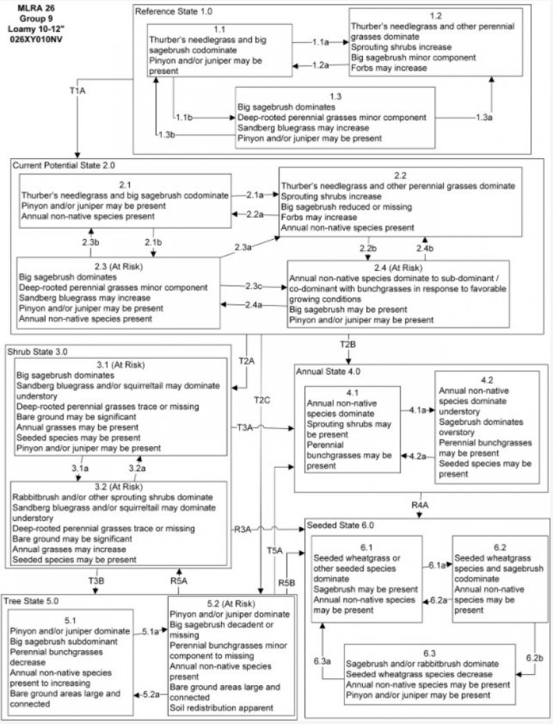
Reference State 1.0: The Reference State 1.0 is a representative of the natural range of variability under pristine conditions. The reference state has three general community phases; a shrub-grass dominant phase, a perennial grass dominant phase and a shrub dominant phase. State dynamics are maintained by interactions between climatic patterns and disturbance regimes. Negative feedbacks enhance ecosystem resilience and contribute to the stability of the state. These include the presence of all structural and functional groups, low fine fuel loads, and retention of organic matter and nutrients. Plant community phase changes are primarily driven by fire, periodic drought and/or insect or disease attack.
Community Phase1.1: Thurber’s needlegrass is codominant with big sagebrush. Sagebrush may be a mix of Wyoming big sagebrush, basin big sagebrush, and mountain big sagebrush. Pinyon and/or juniper may be present.
Community PhasePathway1.1a, from Phase 1.1 to 1.2: Low severity fire creates a sagebrush/grass mosaic. High severity fire significantly reduces sagebrush cover and leads to early/mid-seral community dominated by grasses and forbs. In reference condition, fires would typically be small and patchy due to low fuel loads. A severe infestation of Aroga moth could also cause a large decrease in sagebrush within the community, giving a competitive advantage to the perennial grasses and forbs.
Community Phase Pathway 1.1b, from Phase 1.1 to 1.3: Time and lack of disturbance such as fire or drought allows shrubs to become dominant and may reduce grass production. Excessive herbivory and/or long-term drought may also reduce the perennial understory.
Community Phase 1.2: This community phase is characteristic of a post-disturbance, early to mid-seral community. Bitterbrush, ephedra, and spiny hopsage may be sprouting and may become the dominant shrubs in this phase. Big sagebrush is killed by fire and is reduced within the burned community but may be present in unburned patches. Thurber’s needlegrass can experience high mortality from fire and may be reduced in the community for several years. With low fire severity, Thurber’s needlegrass may dominate the site post-fire.
Community Phase Pathway 1.2a, from Phase 1.2 to 1.1: Time and lack of disturbance allows for shrubs to reestablish.
Community Phase 1.3: Big sagebrush increases in the absence of disturbance. Thurber’s needlegrass and other perennial grasses reduced. Decadent sagebrush dominates the overstory and the deep-rooted perennial bunchgrasses in the understory are reduced either from competition with shrubs or from herbivory. Bluegrass (Poa) species will likely increase in the understory and may be the dominant grass on the site. Pinyon and/or juniper may be present but constitute less than 2% of production on the site.
Community Phase Pathway 1.3a, from Phase 1.3 to 1.2: Fire would decrease or eliminate the overstory of sagebrush and allow for the perennial bunchgrasses to dominate the site. Fires would typically be small and patchy due to low fuel loads. A fire following an unusually wet spring or a change in management may be more severe and reduce sagebrush cover to trace amounts. A severe infestation of Aroga moth could also cause a large decrease in sagebrush within the community, giving a competitive advantage to the perennial grasses and forbs.
Community Phase Pathway 1.3b, from Phase 1.3 to 1.1: Aroga moth infestation and/or release from growing season herbivory may reduce sagebrush dominance and allow recovery of the perennial bunchgrass understory.
T1A: Transition from Reference State 1.0 to Current Potential State 2.0: Trigger: This transition is caused by the introduction of non-native annual weeds, such as cheatgrass, mustards and Russian thistle (Salsola tragus). Slow variables: Over time the annual non-native plants will increase within the community decreasing organic matter inputs from deep-rooted perennial bunchgrasses resulting in reductions in soil water availability for perennial bunchgrasses. Threshold: Any amount of introduced non-native species causes an immediate decrease in the resilience of the site. Annual non-native species cannot be easily removed from the system and have the potential to significantly alter disturbance regimes from their historic range of variation.
Current Potential State 2.0: This state is similar to the Reference State 1.0. Ecological function has not changed; however the resiliency of the state has been reduced by the presence of invasive weeds. This state has the same three general community phases. Negative feedbacks enhance ecosystem resilience and contribute to the stability of the state. These include the presence of all structural and functional groups, low fine fuel loads and retention of organic matter and nutrients. Positive feedbacks decrease ecosystem resilience and stability of the state. These include the non-natives high seed output, persistent seed bank, rapid growth rate, ability to cross-pollinate and adaptations for seed dispersal. Additionally, the presence of highly flammable, non-native species reduces state resilience because these species can promote fire where historically fire has been infrequent leading to positive feedbacks that further the degradation of the system.
Community Phase 2.1: Thurber’s needlegrass is codominant with big sagebrush. Sagebrush may be a mix of Wyoming big sagebrush, basin big sagebrush, and mountain big sagebrush. Pinyon and/or juniper may be present. Non-native annual species are present in minor amounts.
Community Phase Pathway 2.1a, from Phase 2.1 to 2.2: Fire would decrease or eliminate the overstory of sagebrush and allow for the perennial bunchgrasses to dominate the site. Fires would typically be small and patchy due to low fuel loads. A fire following an unusually wet spring or a change in management may be more severe and reduce sagebrush cover to trace amounts. A severe infestation of Aroga moth could also cause a large decrease in sagebrush within the community, giving a competitive advantage to the perennial grasses and forbs. Annual non-native species generally respond well after fire and may be stable or increasing within the community.
Community Phase Pathway 2.1b, from Phase 2.1 to 2.3: Time, long-term drought, grazing management that favors shrubs or combinations of these would allow the sagebrush overstory to increase and dominate the site, causing a reduction in the perennial bunchgrasses. However, Sandberg bluegrass and/or squirreltail may increase in the understory depending on the grazing management. Heavy spring grazing will favor an increase in sagebrush. Annual non-native species may be stable or increasing within the understory.
Community Phase 2.2: This community phase is characteristic of a post-disturbance, early to mid-seral community. Bitterbrush, ephedra, and spiny hopsage may be sprouting and may become the dominant shrubs in this phase. Big sagebrush is killed by fire and is reduced within the burned community but may be present in unburned patches. Thurber’s needlegrass can experience high mortality from fire and may be reduced in the community for several years. With low fire severity, Thurber’s needlegrass may dominate the site post-fire. Annual non-native species generally respond well after fire and may be stable or increasing within the community.
Community Phase Pathway 2.2a, from Phase 2.2 to 2.1: Absence of disturbance over time allows for the sagebrush to recover may be combined with grazing management that favors shrubs.
Community Phase Pathway 2.2b, from Phase 2.2 to 2.4: Higher than normal spring precipitation favors annual non-native species such as cheatgrass. Non-native annual species will increase in production and density throughout the site. Perennial bunchgrasses may also increase in production.
Community Phase 2.3(At Risk): Big sagebrush increases in the absence of disturbance. Thurber’s needlegrass and other perennial grasses reduced. Decadent sagebrush dominates the overstory and the deep-rooted perennial bunchgrasses in the understory are reduced either from competition with shrubs or from herbivory. Bluegrass (Poa) species will likely increase in the understory and may be the dominant grass on the site. Pinyon and/or juniper may be increasing. Annual non-native species are present. This phase may be at risk of transitioning to the Shrub State 3.0 or the Tree State 5.0.
Community Phase Pathway 2.3a, from Phase 2.3 to 2.2: Fire would decrease or eliminate the overstory of sagebrush and allow for the perennial bunchgrasses to dominate the site. Fires would typically be small and patchy due to low fuel loads. A fire following an unusually wet spring or a change in management may be more severe and reduce sagebrush cover to trace amounts. A severe infestation of Aroga moth could also cause a large decrease in sagebrush within the community, giving a competitive advantage to the perennial grasses and forbs.
Community Phase Pathway 2.3b, from Phase 2.3 to 2.1: Low severity fire or Aroga moth infestation creates sagebrush/grass mosaic. Other disturbances/practices include brush management with minimal soil disturbance; late-fall/winter grazing causing mechanical damage to sagebrush.
Community Phase Pathway 2.3c, from Phase 2.3 to 2.4: Fall, winter, and spring precipitation and temperatures mediate the ability for annual grasses and perennial grasses to germinate and/or survive. Higher than normal spring precipitation creates high annual production of annual grasses (Bradley et al. 2016). Non-native annual species increase in production and density throughout the site. Perennial bunchgrasses may also increase in production.
Community Phase 2.4 (At Risk): This community is at risk of crossing into an annual state. Native bunchgrasses dominate; however, annual non-native species such as cheatgrass may be sub or co-dominant in the understory. Annual production and abundance of these annuals may increase drastically in years with heavy spring precipitation. Seeded species may be present. Sagebrush may be present if coming from phase 2.3. This site is susceptible to further degradation from grazing, drought, and fire. Pinyon and/or juniper may be present.
Community Phase Pathway 2.4a, from phase 2.4 to 2.3: Rainfall patterns favoring perennial bunchgrasses. Less than normal spring precipitation followed by higher than normal summer precipitation will increase perennial bunchgrass production.
Community Phase Pathway 2.4b, from phase 2.4 to 2.2: Fall, winter, and spring precipitation and temperatures mediate the ability for annual grasses and perennial grasses to germinate and/or survive. Depending on temperatures and precipitation in winter and spring, annual grass production may be reduced in favor of perennial bunchgrasses.
T2A: Transition from Current Potential State 2.0 to Shrub State 3.0: Trigger: Inappropriate, long-term grazing of perennial bunchgrasses during growing season would favor shrubs and initiate transition to Community Phase 3.1. Fire would cause a transition to Community Phase 3.2.Slow variables: Long term decrease in deep-rooted perennial grass density resulting in a decrease in organic matter inputs and subsequent soil water decline. Threshold: Loss of deep-rooted perennial bunchgrasses changes spatial and temporal nutrient cycling and redistribution and reduces soil organic matter.
T2B: Transition from Current Potential State 2.0 to Annual State 4.0: Trigger: Fire or a failed range seeding leads to plant community phase 4.1. Inappropriate grazing management that favors shrubs in the presence of non-native annual species leads to community phase 4.2. Slow variables: Increased production and cover of non-native annual species. Threshold: Cheatgrass or other non-native annuals dominate understory.
T2C: Transition from Current Potential State 2.0 to Tree State 5.0: Trigger: Lack of fire allows for trees to dominate site; may be coupled with inappropriate grazing management that reduces fine fuels. Slow variables: Increased establishment and cover of juniper/pinyon trees, reduction in organic matter inputs. Threshold: Trees overtop Wyoming big sagebrush and out-compete shrubs for water and sunlight. Shrub skeletons exceed live shrubs with minimal recruitment of new cohorts.
Shrub State 3.0: This state has two community phases; a big sagebrush dominated phase and a sprouting shrub dominated phase. This state is a product of many years of heavy grazing during time periods harmful to perennial bunchgrasses. Sandberg bluegrass will increase with a reduction in deep rooted perennial bunchgrass competition and become the dominant grass. Sagebrush dominates the overstory and sprouting shrubs may be a significant component. Sagebrush canopy cover is high and sagebrush may be decadent, reflecting stand maturity and lack of seedling establishment due to competition with mature plants. The shrub overstory and Sandberg bluegrass understory dominate site resources such that soil water, nutrient capture, nutrient cycling and soil organic matter are temporally and spatially redistributed.
Community Phase 3.1(At Risk): Big sagebrush dominates overstory. Thurber’s needlegrass and other perennial grasses are reduced, with bluegrass species dominant in the understory. Pinyon and juniper may be present. Annual non-native species may be present. Bare ground may be significant. Seeded species may be present. Pinyon and/or juniper may be present or increasing.
Community Phase Pathway 3.1a, from Phase 3.1 to 3.2: Fire would decrease or eliminate the overstory of sagebrush. A severe infestation of Aroga moth could also cause a large decrease in sagebrush within the community, giving a competitive advantage to bluegrasses, forbs and sprouting shrubs. Heavy fall grazing causing mechanical damage to shrubs, and/or brush treatments with minimal soil disturbance, would greatly reduce the overstory shrubs and allow for bluegrasses to dominate the site.
Community Phase 3.2(At Risk): Bluegrass species dominate the understory. Sprouting shrubs may be present. Perennial grasses trace or missing. Annual non-native species dominate understory. Bare ground may be significant. Seeded species may be present.
Community Phase Pathway 3.2a, from Phase 3.2 to 3.1: Absence of disturbance over time would allow for sagebrush and other shrubs to recover.
T3A: Transition from Shrub State 3.0 to Annual State 4.0: Trigger: Fire or inappropriate grazing management can eliminate the Sandberg bluegrass understory and transition to community phase 4.1 or 4.2. Slow variable: Increased seed production and cover of annual non-native species. Threshold: Increased, continuous fine fuels modify the fire regime by changing intensity, size and spatial variability of fires. Changes in plant community composition and spatial variability of vegetation due to the loss of perennial bunchgrasses and sagebrush truncate energy capture and impact the nutrient cycling and distribution.
T3B: Transition from Shrub State 3.0 to Tree State 5.0: Trigger: Lack of fire allows for trees to dominate site; may be coupled with inappropriate grazing management that reduces fine fuels. Slow variables: Increased establishment and cover of juniper/pinyon trees, reduction in organic matter inputs. Threshold: Trees overtop Wyoming big sagebrush and out-compete shrubs for water and sunlight. Shrub skeletons exceed live shrubs with minimal recruitment of new cohorts.
R3A: Restoration from Shrub State 3.0 to Seeded State 6.0: Brush management, herbicide, and seeding of crested wheatgrass (Agropyron cristatum) and/or other desired species.
Annual State 4.0: This state has two community phases; one dominated by annual non-native species and the other is a shrub dominated state. This state is characterized by the dominance of annual non-native species such as cheatgrass in the understory. Sagebrush and/or sprouting shrubs may dominate the overstory.
Community Phase 4.1: Annual non-native plants such as cheatgrass dominate the site. Perennial plants are a minor component or missing from the site. This phase may have seeded species present if resulting from a failed seeding attempt.
Community Phase Pathway 4.1a, from Phase 4.1 to 4.2: Time and lack of disturbance allows for shrubs to reestablish. Sprouting shrubs such as ephedra, desert peach and rabbitbrush will be the first to reappear after fire. Probability of sagebrush establishment is extremely low.
Community Phase 4.2: Annual non-native species dominate understory. Sagebrush or sprouting shrubs dominate the overstory. Perennial bunchgrasses are a minor component. This phase may have seeded species present if resulting from a failed seeding attempt.
Community Phase Pathway 4.2a, from Phase 4.2 to 4.1: Fire kills shrubs and allows for annual non-native species to dominate the site.
R4A: Restoration from Annual State 4.0 to Seeded State 6.0: Application of herbicide and seeding of desired species. Probability of success is best immediately following fire.
Tree State5.0: This state has two community phases that are characterized by the dominance of Utah juniper and/or singleleaf pinyon in the overstory. Wyoming big sagebrush and perennial bunchgrasses may still be present, but they are no longer controlling site resources. Soil moisture, soil nutrients, soil organic matter distribution and nutrient cycling have been spatially and temporally altered.
Community Phase 5.1: Utah juniper and/or singleleaf pinyon dominate overstory. Big sagebrush is subdominant and may be decadent. Thurber’s needlegrass and other perennial grasses are reduced. Annual non-native may be present. Bare ground areas are large and connected.
Community Phase Pathway 5.1a, from Phase 5.1 to 5.2: Absence of disturbance over time allows for tree cover and density to further increase and out-compete the herbaceous understory species.
Community Phase 5.2 (At Risk): Utah juniper and/or singleleaf pinyon dominates the site and tree leader growth is minimal; annual non-native species may be the dominant understory species and will typically be found under the tree canopies. Trace amounts of sagebrush may be present, however dead shrub skeletons will be more numerous than living sagebrush. Bunchgrasses may or may not be present. Bottlebrush squirreltail or mat forming forbs may be present in trace amounts. Bare ground interspaces are large and connected. Soil redistribution is evident.
Community Phase Pathway 5.2a, from phase 5.2 to 5.1: Manual or mechanical thinning of trees allows understory regrowth due to less competition for resources. This treatment is typically done for fuel management.
T5A: Transition from Tree State 5.0 to Annual State 4.0: Trigger: Catastrophic crown fire would reduce or eliminate trees to transition the site to 4.1. Tree removal when annual non-natives such as cheatgrass are present would also transition the site to state 4.0. Slow variable: Increased seed production and cover of annual non-native species. Threshold: Increased, continuous fine fuels modify the fire regime by changing intensity, size and spatial variability of fires. Changes in plant community composition and spatial variability of vegetation due to the loss of perennial bunchgrasses and sagebrush truncate energy capture and impact the nutrient cycling and distribution.
R5A: Restoration from Tree State 5.0 to Shrub State 3.0: Tree removal with no seeding. Treatments done in phase 5.1 will be more successful. Tree removal practices that minimize soil disturbance are recommended. Probability of success declines with increased presence of nonnative annual species.
R5B: Restoration from Tree State 5.0 to Seeded State 6.0: Tree removal and seeding of desired species. Tree removal practices that minimize soil disturbance are recommended. Probability of success declines with increased presence of nonnative annual species.
Seeded State 6.0: This state has three community phases; a grass-dominated phase, and grass-shrub dominated phase, and a shrub dominated phase. This state is characterized by the dominance of seeded introduced wheatgrass species in the understory. Forage kochia (Bassia prostrata) and other desired seeded species including Wyoming big sagebrush, native and non-native forbs may be present.
Community Phase 6.1: Seeded wheatgrass and/or other seeded species dominate the community. Non-native annual species are present. Trace amounts of big sagebrush may be present, especially if seeded.
Community Phase Pathway 6.1a, from Phase 6.1 to 6.2: Time and lack of disturbance allow shrubs to increase. Pathway may be coupled with inappropriate grazing management.
Community Phase 6.2: Big sagebrush increases and may be codominant with seeded wheatgrass species. Annual non-native species may be present in trace amounts.
Community Phase Pathway 6.2a, from Phase 6.2 to 6.1: Fire and/or brush management allows seeded grasses to return to dominance.
Community Phase Pathway 6.2b, from Phase 6.2 to 6.3: Inappropriate grazing reduces bunchgrasses and increases density of sagebrush. This is usually a slow transition.
Community Phase 6.3: Sagebrush and/or sprouting shrubs dominate. Seeded wheatgrass species decrease. Annual non-native species may be present. Pinyon and /or juniper may be present.
Community Phase Pathway 6.3a, from Phase 6.3to 6.1: Fire or brush management with minimal soil disturbance.
State 1
Reference Plant Community
Community 1.1
Reference Plant Community
The reference plant community is dominated by desert needlegrass, antelope bitterbrush, Wyoming big sagebrush, and green ephedra. Potential vegetative composition is about 50% grasses, 5% forbs and 45% shrubs. Approximate ground cover (basal and crown) is 20 to 25 percent.
Table 6. Annual production by plant type
| Plant type |
Low
(lb/acre) |
Representative value
(lb/acre) |
High
(lb/acre) |
| Grass/Grasslike |
200 |
300 |
400 |
| Shrub/Vine |
180 |
270 |
360 |
| Forb |
20 |
30 |
40 |
| Total |
400 |
600 |
800 |