Ecological dynamics
As ecological condition declines, mountain big sagebrush and Douglas' rabbitbrush become dominant. Species most likely to invade this site are annuals.
Fire Ecology:
Presettlement fire return intervals in mountain big sagebrush communities varied from 15 to 25 years. Mountain big sagebrush is highly susceptible to injury from fire. Plants are readily killed in all seasons, even light severity fires. Mountain big sagebrush plants top-killed by fire will not resprout. It is considered a weak sprouter and is often killed by summer or fall fire. Antelope bitterbrush in some areas may sprout after light-severity spring fire. Season of burning and environmental conditions impact antelope bitterbrush ability to survive fire and sprout. High fuel consumptions increase antelope bitterbrush mortality and therefore favors seedling establishment.
Thurber needlegrass is classified as moderately resistant, but depending on season of burn, phenology, and fire severity, this perennial bunchgrass is moderately to severely damaged by fire. Burning has been found to decrease the vegetation and reproductive vigor. Early season burning is more damaging to this needlegrass than late season burning.
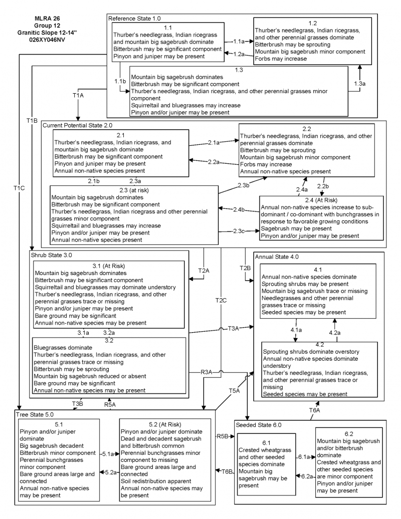
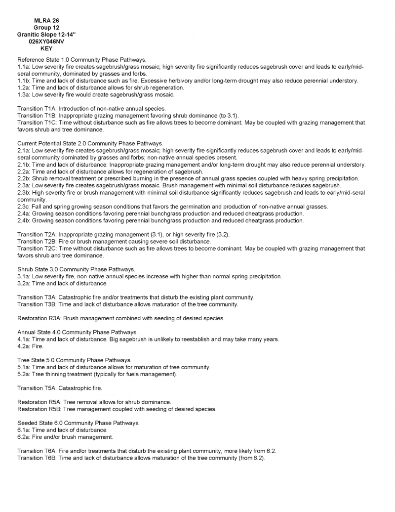
State and Transition Model Narrative Group 12:
This is a text description of the states, phases, transitions, and community pathways possible in the State and Transition model for the MLRA 26 Disturbance Response Group 12. Site included in this DRG are: R026XY005NV, R026XY105NV, R026XY046NV, R026XY006NV, R026XY048NV, R026XY111NV, R026XY040NV, R026XY106NV, R026XY089NV, R026XF057CA, R026XF063CA, and R026XF064CA.
The ecological sites in this DRG have low to moderate resilience to disturbance and resistance to invasion. Resilience increases with elevation, aspect, increased precipitation and increased nutrient availability. Long-term disturbance response may be influenced by small differences in landscape topography. North slopes are also more resilient than south slopes because lower soil surface temperatures operate to keep moisture content higher on northern exposures. Six possible alternative stable states have been identified for this DRG.
Reference State 1.0:
The Reference State 1.0 represents the natural range of variability of this site under pristine conditions. The reference state has three general community phases: a shrub-grass dominant phase, a perennial grass dominant phase and a shrub dominant phase. State dynamics are maintained by interactions between climatic patterns and disturbance regimes. Negative feedbacks enhance ecosystem resilience and contribute to the stability of the state. These include the presence of all structural and functional groups, low fine fuel loads, and retention of organic matter and nutrients. Plant community phase changes are primarily driven by fire, periodic drought, and/or insect or disease attack.
Community Phase 1.1:
Needlegrasses, basin wildrye, and mountain big sagebrush dominate the site. Bitterbrush may be a significant component. Pinyon and juniper may be present.
Community Phase Pathway 1.1a, from phase 1.1 to 1.2:
Fire would decrease or eliminate the overstory of sagebrush and allow for the perennial bunchgrasses and perennial forbs to dominate the site. Fires would typically be small and patchy due to low fuel loads. Low severity fire creates sagebrush/grass mosaic. High severity fire significantly reduces sagebrush cover and leads to early/mid-seral community, dominated by grasses and forbs.
Community Phase Pathway 1.1b, from phase 1.1 to 1.3:
Time and lack of disturbance such as fire or drought allow for an increase in mountain big sagebrush. Excessive herbivory and/or long-term drought may also reduce perennial understory.
Community Phase 1.2:
This community phase is characteristic of a post-disturbance, early- to mid-seral plant community. Needlegrasses, basin wildrye, and perennial grasses and forbs dominate. Mountain big sagebrush is a minor component. Bitterbrush may be sprouting. Forbs may increase.
Community Phase Pathway 1.2a, from phase 1.2 to 1.1:
Time and lack of disturbance allows for sagebrush to reestablish.
Community Phase 1.3:
Mountain big sagebrush increases in the absence of disturbance and becomes dominant. Bitterbrush may be a significant component. Needlegrasses and other perennial grasses are reduced. Squirreltail and/or bluegrasses may increase. Pinyon and juniper may be present.
Community Phase Pathway 1.3a, from phase 1.3 to 1.2:
Fire. A low severity fire creates a sagebrush/grass mosaic, while a high-severity fire reduces sagebrush to trace amounts.
T1A: Transition from Reference State 1.0 to Current Potential State 2.0
Trigger: This transition is caused by the introduction of non-native annual weeds, such as cheatgrass, mustard and Russian thistle (Salsola tragus).
Slow variables: Over time the annual non-native plants will increase within the community, decreasing organic matter inputs from deep-rooted perennial bunchgrasses. This results in reductions in soil water availability for perennial bunchgrasses.
Threshold: Any amount of introduced non-native species causes an immediate decrease in the resilience of the site. Annual non-native species cannot be easily removed from the system and have the potential to significantly alter disturbance regimes from their historic range of variation.
T1B: Transition from Reference State 1.0 to Shrub State 3.0
Trigger: Inappropriate, long-term grazing of perennial bunchgrasses during the growing season would favor shrubs and initiate transition to Community Phase 3.1.
Slow variables: Long term decrease in deep-rooted perennial grass density.
Threshold: Loss of deep-rooted perennial bunchgrasses changes spatial and temporal nutrient cycling and nutrient redistribution and reduces soil organic matter and soil moisture.
T1C: Transition from Reference State 1.0 to Tree State 5.0
Trigger: Time and lack of disturbance or management action allows pinyon or juniper to dominate. This may be coupled with grazing management that favors tree establishment by reducing understory herbaceous competition for site resources.
Feedbacks and ecological processes: Trees increasingly dominate use of soil water, contributing to reductions in soil water availability to grasses and shrubs. Overtime, grasses and shrubs are outcompeted. Reduced herbaceous and shrub production slows soil organic matter inputs and increases soil erodibility through loss of cover and root structure.
Slow variables: Over time the abundance and size of trees will increase.
Threshold: Trees dominate ecological processes and the number of shrub skeletons exceed number of live shrubs.
Current Potential State 2.0:
This state is similar to the Reference State 1.0. Ecological function has not changed, however, the resiliency of the state has been reduced by the presence of invasive weeds. This state has four general community phases. Negative feedbacks enhance ecosystem resilience and contribute to the stability of the state. These include the presence of all structural and functional groups, low fine fuel loads and retention of organic matter and nutrients. Positive feedbacks decrease ecosystem resilience and stability of the state. These include the non-natives high seed output, persistent seed bank, rapid growth rate, ability to cross pollinate and adaptations for seed dispersal. Additionally, the presence of highly flammable, non-native species reduces State resilience because these species can promote fire where historically fire has been infrequent leading to positive feedbacks that further the degradation of the system.
Community Phase 2.1:
Needlegrasses, basin wildrye and mountain big sagebrush dominate the site. Bitterbrush may be a significant component. Pinyon and juniper may be present. Annual non-native species present.
Community Phase Pathway 2.1a, from phase 2.1 to 2.2:
Fire. Low severity fire creates sagebrush/grass mosaic while a high severity fire significantly reduces sagebrush cover and leads to early/mid-seral community dominated by grasses and forbs. Non-native annual species present.
Community Phase Pathway 2.1b, from phase 2.1 to 2.3:
Time, lack of disturbance, long-term drought, grazing management that favors shrubs or combinations of these would allow the sagebrush overstory to increase and dominate the site, causing a reduction in the perennial bunchgrasses.
Community Phase 2.2:
This community phase is characteristic of a post-disturbance, early-seral plant community. Needlegrasses and other perennial grasses and perennial forbs dominate. Mountain big sagebrush is a minor component. Bitterbrush may be sprouting. Forbs may increase. Annual non-native species are present.
Community Phase Pathway 2.2a, from phase 2.2 to 2.1:
Absence of disturbance over time allows for the sagebrush to recover. This may be combined with grazing management that favors shrubs.
Community Phase Pathway 2.2b, from Phase 2.2 to 2.4:
Higher than normal spring precipitation favors annual non-native species such as cheatgrass. Non-native annual species will increase in production and density throughout the site. Shrub removal or prescribed burning may increase invasive annuals. Perennial bunchgrasses may also increase in production.
Community Phase 2.3:
Mountain big sagebrush is dominant and the perennial understory is reduced. Bitterbrush may be a significant component. Bluegrass may increase. Pinyon and juniper may be present. Annual non-native species are present.
Community Phase Pathway 2.3a, from phase 2.3 to 2.1:
Low severity fire creates sagebrush/grass mosaic. Other disturbances/practices include brush management with minimal soil disturbance leading to a reduction in sagebrush.
Community Phase Pathway 2.3b, from phase 2.3 to 2.2:
High severity fire or brush management with minimal soil disturbance significantly reduces sagebrush and leads to early/mid-seral community.
Community Phase Pathway 2.3c, from phase 2.3 to 2.4:
Fall and spring growing season conditions that favor the germination and production of non-native annual grasses.
Community Phase 2.4:
This community is at risk of crossing to an annual state. Native bunchgrasses and forbs still comprise 50% or more of the understory annual production, however non-native annual grasses are nearly codominant. If this site originated from phase 2.3 there may be significant shrub cover as well. Annual production and abundance of these annuals may increase drastically in years with heavy spring precipitation. This site is susceptible to further degradation from grazing, drought, and fire.
Community Phase Pathway 2.4a, from phase 2.4 to 2.2:
Growing season conditions favoring perennial bunchgrass production and reduced cheatgrass production.
Community Phase Pathway 2.4b, from phase 2.4 to 2.3:
Growing season conditions favoring perennial bunchgrass production and reduced cheatgrass production.
T2A: Transition from Current Potential State 2.0 to Shrub State 3.0:
Trigger: Inappropriate, long-term grazing of perennial bunchgrasses during growing season would favor shrubs and initiate transition to Community Phase 3.1.
Slow variables: Long term declines in deep-rooted perennial grass density.
Threshold: Loss of deep-rooted perennial bunchgrasses changes spatial and temporal nutrient cycling and nutrient redistribution and reduces soil organic matter.
T2B: Transition from Current Potential State 2.0 to Annual State 4.0:
Trigger: Fire and/or multiple fires lead to plant community phase 4.1, inappropriate grazing management that favors shrubs in the presence of non-native annual species leads to community phase 4.2.
Slow variables: Increased production and cover of non-native annual species.
Threshold: Loss of deep-rooted perennial bunchgrasses and shrubs truncates, spatially and temporally, nutrient capture and cycling within the community. Increased, continuous fine fuels from annual non-native plants modify the fire regime by changing intensity, size and spatial variability of fires.
T2C: Transition from Current Potential 2.0 to Tree State 5.0:
Trigger: Time and lack of disturbance or management action allows pinyon and juniper to dominate. This may be coupled with grazing management that favors tree establishment by reducing understory herbaceous competition for site resources.
Feedbacks and ecological processes: Trees increasingly dominate use of soil water, contributing to reductions in soil water availability to grasses and shrubs. Overtime, grasses and shrubs are outcompeted. Reduced herbaceous and shrub production slows soil organic matter inputs and increases soil erodibility through loss of cover and root structure.
Slow variables: Over time the abundance and size of trees will increase.
Threshold: Trees dominate ecological processes and number of shrub skeletons exceed the number of live shrubs.
Shrub State 3.0:
This state has two community phases: a mountain big sagebrush dominated phase and a squirreltail-dominated phase. This state is a product of many years of heavy grazing during time periods harmful to perennial bunchgrasses. Squirreltail will increase with a reduction in deep rooted perennial bunchgrass competition and become the dominant grass. Sagebrush and bitterbrush dominate the overstory. Sagebrush canopy cover is high and sagebrush may be decadent, reflecting stand maturity and lack of seedling establishment due to competition with mature plants. The shrub overstory and bluegrass understory dominate site resources such that soil water, nutrient capture, nutrient cycling and soil organic matter are temporally and spatially redistributed.
Community Phase 3.1:
This site is at risk of transitioning to another state. Mountain big sagebrush, possibly decadent, dominates the overstory. Antelope bitterbrush may be a significant component. Deep-rooted perennial bunchgrasses are present in only trace amounts and may be absent from the community. Squirreltail may be dominant in the understory. Understory may be sparse, with bare ground increasing. Pinyon and/or juniper may be present as a result of encroachment from neighboring sites and lack of disturbance. Annual non-native species are present to increasing.
Community Phase Pathway 3.1a, from phase 3.1 to 3.2:
Fire reduces or eliminates the overstory of sagebrush. Non-native annual species increase with higher-than-normal spring precipitation.
Community Phase 3.2:
Squirreltail dominates the site. Needlegrasses and other perennial grasses are reduced. Mountain big sagebrush is reduced or missing. Bitterbrush may be sprouting. Annual non-native species are increasing and may be co-dominant in the understory.
Community Phase Pathway 3.2a, from phase 3.2 to 3.1:
Absence of disturbance over time would allow for sagebrush and other shrubs to recover.
T3A: Transition from Shrub State 3.0 to Annual State 4.0:
Trigger: Fire or inappropriate grazing management can eliminate the squirreltail understory and transition to community phase 4.1 or 4.2.
Slow variable: Increased seed production and cover of annual non-native species.
Threshold: Increased, continuous fine fuels modify the fire regime by changing intensity, size and spatial variability of fires. Changes in plant community composition and spatial variability of vegetation due to the loss of perennial bunchgrasses and big sagebrush truncate energy capture and impact the nutrient cycling and distribution.
T3B: Transition from Shrub State 3.0 to Tree State 5.0:
Trigger: Time and lack of disturbance allows for maturation of the tree community. This may be coupled with grazing management that favors shrub and tree growth.
Slow variable: Over time, with lack of fire, the abundance and size of trees increase.
Threshold: Trees overtop mountain big sagebrush and out-compete shrubs for water and sunlight. Shrub skeletons exceed live shrubs with minimal recruitment of new cohorts. Bare ground areas are large and connected.
R3A: Restoration from Shrub State 3.0 to Seeded State 6.0:
Brush management and seeding of crested wheatgrass and/or other desired species. Presence of non-native annual species will make this restoration pathway difficult.
Annual State 4.0:
This state has two community phases, both characterized by a dominance of non-native annual grasses and forbs. Shrub cover is present in one phase, while the other is primarily annual grasses. Sagebrush and/or rabbitbrush may dominate the overstory. Annual non-native species dominate the understory. Ecological dynamics are significantly altered in this state. Annual non-native species create a highly combustible fuel bed that shortens the fire return interval. Nutrient cycling is spatially and temporally truncated as annual plants contribute significantly less to deep soil carbon. Because this is a productive site, some deep-rooted perennial grasses may remain, even in the annual state. Without management, it is unlikely these plants will be able to recruit in the presence of dominant annual grasses.
Community Phase 4.1:
Annual non-native plants such as cheatgrass dominate the site. This phase may have seeded species present if resulting from a failed seeding attempt. Needlegrasses, mountain big sagebrush, and other shrubs are only present in trace amounts and may be missing from the community.
Community Phase Pathway 4.1a, from phase 4.1 to phase 4.2:
Time and lack of disturbance allows for shrubs to reestablish. Probability of sagebrush reestablishment is extremely low.
Community Phase 4.2:
Annual non-native species, primarily cheatgrass, dominate the understory. Sprouting shrubs dominate the overstory. Perennial bunchgrasses are a minor component or missing. Seeded species may be present.
Community Phase Pathway 4.2a, from phase 4.2 to 4.1:
Fire kills non-sprouting shrubs and allows annual non-native species to dominate site.
Tree State 5.0:
This state is characterized by a dominance of pinyon and/or juniper in the overstory. It occurs where sagebrush sites exist adjacent to stands of trees. Big sagebrush and perennial bunchgrasses may still be present, but they are no longer controlling site resources. Skeletons of dead sagebrush plants are apparent. Soil moisture, soil nutrients, soil organic matter distribution and nutrient cycling have been spatially and temporally altered.
Community Phase 5.1:
Pinyon and juniper dominate. Trees are actively growing with noticeable leader growth. Mountain big sagebrush is stressed and dying. Needlegrass and other perennial grasses reduced. Annual non-native species are present under tree canopies. Bare ground interspaces are large and connected.
Community Phase Pathway 5.1a, from phase 5.1 to 5.2:
Absence of disturbance over time allows for tree cover and density to further increase and out-compete the herbaceous understory species for sunlight and water.
Community Phase 5.2:
Pinyon and/or juniper dominate the site and tree leader growth is minimal. Annual non-native species may be the dominant understory species and will typically be found under tree canopies. Trace amounts of sagebrush may be present, however dead skeletons will be more numerous than living sagebrush. Bunchgrass may or may not be present. Bare ground areas are large and connected, and soil redistribution is apparent.
Community Phase Pathway 5.2a, from phase 5.2 to 5.1:
Tree thinning treatment (typically for fuels management) removes some tree cover and may allow sagebrush to survive. Without further management this pathway is temporary.
T5A: Transition from Tree State 5.0 to Annual State 4.0:
Trigger: Catastrophic crown fire would reduce or eliminate trees to transition the site to 4.1. Tree removal when annual non-natives such as cheatgrass are present would also transition the site to state 4.0.
Slow variable: Increased seed production and cover of annual non-native species.
Threshold: Increased, continuous fine fuels modify the fire regime by changing intensity, size and spatial variability of fires. Changes in plant community composition and spatial variability of vegetation due to the loss of perennial bunchgrasses and sagebrush truncate energy capture and impact the nutrient cycling and distribution.
R5A: Restoration from Tree State 5.0 to Shrub State 6.0:
Tree removal with minimum soil disturbance such as hand felling or mastication within community phase 5.1 when native grasses are still present.
R5B: Restoration from Tree State 5.0 to Seeded State 6.0:
Tree removal and seeding of desired species. Tree removal practices that minimize soil disturbance are recommended. Probability of success declines with increased presence of non-native annual species.
Seeded State 6.0:
This state has two community phases: a grass-dominated phase and a shrub dominated phase. This state is characterized by the dominance of seeded introduced wheatgrass species in the understory. Crested wheatgrass is a dominant plant in this phase. Conservation practices such as brush management and prescribed grazing should be used to maintain the perennial bunchgrasses and other desirable species.
Community Phase 6.1:
Seeded wheatgrasses and/or other seeded species dominate the community. Non-native annual species are present. Trace amounts of mountain big sagebrush may be present, especially if seeded.
Community Phase Pathway 6.1a, from phase 6.1 to 6.2:
Time and lack of disturbance allows shrubs to dominate. This process may be accelerated through inappropriate grazing management.
Community Phase 6.2:
Mountain big sagebrush and/or bitterbrush increases and dominates the overstory. Seeded wheatgrass species are a minor component. Annual non-native species may be present in trace amounts. Pinyon and/or juniper may be present.
Community Phase Pathway 6.2a, from phase 6.2 to 6.1:
Fire, brush management and/or Aroga moth infestation reduces sagebrush overstory and allows for seeded wheatgrasses or other seeded grasses to increase.
T6A: Transition from Seeded State 6.0 to Annual State 4.0:
Trigger: Catastrophic fire.
Slow variables: Increased production and cover of non-native annual species.
Threshold: Increased continuous fine fuels modify the fire regime by changing intensity, size, and spatial variability of fires. Changes in plant community composition and spatial variability of vegetation due to the loss of perennial bunchgrasses and sagebrush truncate energy capture spatially and temporally, thus impacting nutrient cycling and distribution.
T6B: Transition from Seeded State 6.0 to Tree State 5.0:
Trigger: Time and lack of disturbance or management action allows for pinyon and/or juniper to dominate. This may be coupled with grazing management that favors tree establishment by reducing understory herbaceous competition for site resources.
Slow variables: Over time, the abundance and size of trees will increase.
Threshold: Trees dominate ecological processes and number of shrub skeletons exceed number of live shrubs.
State 1
Reference Plant Community
Community 1.1
Reference Plant Community
The reference plant community is dominated by Thurber's needlegrass and/or western needlegrass, mountain big sagebrush and antelope bitterbrush. Potential vegetative composition is about 50% grasses, 5% forbs and 45% shrubs. Approximate ground cover (basal and crown) is 25 to 35 percent.
Table 5. Annual production by plant type
| Plant type |
Low
(lb/acre) |
Representative value
(lb/acre) |
High
(lb/acre) |
| Grass/Grasslike |
250 |
350 |
450 |
| Shrub/Vine |
225 |
315 |
405 |
| Forb |
25 |
35 |
45 |
| Total |
500 |
700 |
900 |