Provisional. A provisional ecological site description has undergone quality control and quality assurance review. It contains a working state and transition model and enough information to identify the ecological site.
MLRA notes
Major Land Resource Area (MLRA): 026X–Carson Basin and Mountains
The area lies within western Nevada and eastern California, with about 69 percent being within Nevada, and 31 percent being within California. Almost all this area is in the Great Basin Section of the Basin and Range Province of the Intermontane Plateaus. Isolated north-south trending mountain ranges are separated by aggraded desert plains. The mountains are uplifted fault blocks with steep side slopes. Most of the valleys are drained by three major rivers flowing east across this MLRA. A narrow strip along the western border of the area is in the Sierra Nevada Section of the Cascade-Sierra Mountains Province of the Pacific Mountain System. The Sierra Nevada Mountains are primarily a large fault block that has been uplifted with a dominant tilt to the west. This structure leaves an impressive wall of mountains directly west of this area. This helps create a rain shadow affect to MLRA 26. Parts of this eastern face, but mostly just the foothills, mark the western boundary of this area. Elevations range from about 3,806 feet (1,160 meters) on the west shore of Pyramid Lake to 11,653 feet (3,552 meters) on the summit of Mount Patterson in the Sweetwater Mountains.
Valley areas are dominantly composed of Quaternary alluvial deposits with Quaternary playa or alluvial flat deposits often occupying the lowest valley bottoms in the internally drained valleys, and river deposited alluvium being dominant in externally drained valleys. Hills and mountains are dominantly Tertiary andesitic flows, breccias, ash flow tuffs, rhyolite tuffs or granodioritic rocks. Quaternary basalt flows are present in lesser amounts, and Jurassic and Triassic limestone and shale, and Precambrian limestone and dolomite are also present in very limited amounts. Also of limited extent are glacial till deposits along the east flank of the Sierra Nevada Mountains, the result of alpine glaciation.
The average annual precipitation in this area is 5 to 36 inches (125 to 915 millimeters), increasing with elevation. Most of the rainfall occurs as high-intensity, convective storms in spring and autumn. Precipitation is mostly snow in winter. Summers are dry. The average annual temperature is 37 to 54 degrees F (3 to 12 degrees C). The freeze-free period averages 115 days and ranges from 40 to 195 days, decreasing in length with elevation.
The dominant soil orders in this MLRA are Aridisols and Mollisols. The soils in the area dominantly have a mesic soil temperature regime, an aridic or xeric soil moisture regime, and mixed or smectitic mineralogy. They generally are well drained, are clayey or loamy and commonly skeletal, and are very shallow to moderately deep.
This area supports shrub-grass vegetation characterized by big sagebrush. Low sagebrush and Lahontan sagebrush occur on some soils. Antelope bitterbrush, squirreltail, desert needlegrass, Thurber needlegrass, and Indian ricegrass are important associated plants. Green ephedra, Sandberg bluegrass, Anderson peachbrush, and several forb species also are common. Juniper-pinyon woodland is typical on mountain slopes. Jeffrey pine, lodgepole pine, white fir, and manzanita grow on the highest mountain slopes. Shadscale is the typical plant in the drier parts of the area. Sedges, rushes, and moisture-loving grasses grow on the wettest parts of the wet flood plains and terraces. Basin wildrye, alkali sacaton, saltgrass, buffaloberry, black greasewood, and rubber rabbitbrush grow on the drier sites that have a high concentration of salts.
Some of the major wildlife species in this area are mule deer, coyote, beaver, muskrat, jackrabbit, cottontail, raptors, pheasant, chukar, blue grouse, mountain quail, and mourning dove. The species of fish in the area include trout and catfish. The Lahontan cutthroat trout in the Truckee River is a threatened and endangered species.
LRU notes
The Semiarid Fans and Basins LRU includes basins, alluvial fans and adjacent hill slopes immediately east of the Sierra Nevada mountain range and are affected by its climate or have its granitic substrate. Elevations range from 1355 to 1920 meters and slopes range from 0 to 30 percent, with a median value of 6 percent. Frost free days range from 121 to 170.
Ecological site concept
The Claypan 8-10 P.Z. is found on fan remnants, hills, and pediments at elevations between 4400 and 6600 feet. Slopes on the Claypan 8-10 P.Z. site are low to steep (2 to 50 percent). The soil is shallow to moderately deep to a duripan or lithic bedrock. The surface soil texture varies from very stony or very gravelly loam to extremely cobbly sandy loam. The dominant plant species are little sagebrush, Thurber's needlegrass, and Sandberg bluegrass.
This site occurs on fan remnants, hills, and pediments. Slopes generally range from 2 to 50 percent. Elevations are 4400 to 6600 feet.
Table 2. Representative physiographic features
Landforms
(1) Fan remnant (2) Hill (3) Pediment
Elevation
1,341–2,012 m
Slope
2–50%
Aspect
Aspect is not a significant factor
Climatic features
The climate associated with this site is arid, characterized by cool, moist winters and warm, dry summers. Average annual precipitation is 8 to 10 inches. Mean annual air temperature air is 45 to 53 degrees F. The average growing season is about 60 to 130 days.
Nevada’s climate is predominantly arid, with large daily ranges of temperature, infrequent severe storms, heavy snowfall in the higher mountains, and great location variations with elevation. Three basic geographical factors largely influence Nevada’s climate: continentality, latitude, and elevation. Continentality is the most important factor. The strong continental effect is expressed in the form of both dryness and large temperature variations. Nevada lies on the eastern, lee side of the Sierra Nevada Range, a massive mountain barrier that markedly influences the climate of the State. The prevailing winds are from the west, and as the warm moist air from the Pacific Ocean ascend the western slopes of the Sierra Range, the air cools, condensation occurs and most of the moisture falls as precipitation. As the air descends the eastern slope, it is warmed by compression, and very little precipitation occurs. The effects of this mountain barrier are felt not only in the West but throughout the state, with the result that the lowlands of Nevada are largely desert or steppes. The temperature regime is also affected by the blocking of the inland-moving maritime air. Nevada sheltered from maritime winds, has a continental climate with well-developed seasons and the terrain responds quickly to changes in solar heating.
Nevada lies within the mid-latitude belt of prevailing westerly winds which occur most of the year. These winds bring frequent changes in weather during the late fall, winter and spring months, when most of the precipitation occurs. To the south of the mid-latitude westerlies, lies a zone of high pressure in subtropical latitudes, with a center over the Pacific Ocean. In the summer, this high-pressure belt shifts northward over the latitudes of Nevada, blocking storms from the ocean. The resulting weather is mostly clear and dry during the summer and early fall, with scattered thundershowers. The eastern portion of the state receives significant summer thunderstorms generated from monsoonal moisture pushed up from the Gulf of California, known as the North American monsoon. The monsoon system peaks in August and by October the monsoon high over the Western U.S. begins to weaken and the precipitation retreats southward towards the tropics (NOAA 2004).
Table 3. Representative climatic features
Frost-free period (characteristic range)
Freeze-free period (characteristic range)
Precipitation total (characteristic range)
203-254 mm
Frost-free period (average)
95 days
Freeze-free period (average)
Precipitation total (average)
229 mm
Bar
Line
Figure 1. Monthly precipitation range
Bar
Line
Figure 2. Monthly average minimum and maximum temperature
Figure 3. Annual precipitation pattern
Figure 4. Annual average temperature pattern
Influencing water features
There are no influencing water features associated with this site.
Soil features
The soils of this site are shallow to moderately deep to bedrock or a duripan and are well drained. They are formed in alluvium, residuum, or colluvium from mixed igneous rocks. The available water capacity is very low to low. The dense clay subsoil (argillic horizon) is the most limiting factor in the development of this plant community. The presence of the clay restricts deep rooting by most plants. Very fine and fine roots penetrate the clay subsoil along ped faces while medium and coarse roots are confined in the surface layer above the clay. The thickness of the soil surface layer ranges from 2 to 9 inches. Soils having surface layers of 5 to 9 inches exhibit an increased productivity and plant density because of the greater soil volume. Although the soils have a medium to high runoff, plants are only able to use the moisture in the surface layer and to a limited extent, the moisture in the clay subsoil. Shrink-swell and frost action in the clay subsoil brings stones to the surface as they increase, space and plant density are reduced. The soil moisture regime is aridic bordering on xeric and the soil temperature regime is mesic.
The soil series associated with this site include: Indian Creek, Reno, Xman, Olac, Chalco, Oppio, Pahrange, Loomer, Tenpin, Stodick, Pulcan, Phing, Fleischmann, Zephan, Verdico, and Pung.
A representative soil series is Indian Creek, a clayey, smectitic, mesic, shallow Xeric Argidurids. An ochric epipedon occurs from the soil surface to 8 cm. An argillic horizon occurs from 8 to 50 cm and a duripan occurs from 50 to 64 cm.
Table 4. Representative soil features
Parent material
(1) Residuum–volcanic rock (2) Alluvium (3) Colluvium–volcanic rock
Surface texture
(1) Very stony loam
(2) Very cobbly sandy loam
(3) Very gravelly loam
Family particle size
(1) Clayey
Drainage class
Well drained
Permeability class
Very slow to moderate
Soil depth
20–99 cm
Surface fragment cover <=3"
9–40%
Surface fragment cover >3"
2–30%
Available water capacity (0-101.6cm)
1.52–11.94 cm
Calcium carbonate equivalent (0-101.6cm)
0%
Electrical conductivity (0-101.6cm)
0–2 mmhos/cm
Sodium adsorption ratio (0-101.6cm)
0–1
Soil reaction (1:1 water) (0-101.6cm)
5.6–7.8
Subsurface fragment volume <=3" (Depth not specified)
7–60%
Subsurface fragment volume >3" (Depth not specified)
0–9%
Ecological dynamics
As ecological condition declines, low sagebrush, rabbitbrush, and littleleaf horsebrush become more dominant. Species most likely to invade this site are cheatgrass, rabbitbrush, horsebrush, snakeweed, Russian thistle, annual mustards, and annuals.
Fire Ecology:
Prior to 1897, mean fire return intervals for low sagebrush communities have been estimated to be from 35 to over 100 years. Fire most often occurs during wet years with high forage production. Low sagebrush is very susceptible to fire damage. Low sagebrush is usually killed by fire and does not re-sprout. The recovery in burned areas is usually via small, light, wind-dispersed seed for all low sagebrush subspecies. Partially injured low sagebrush may re-grow from living branches, but sprouting does not occur. Thurber’s needlegrass is classified as moderately resistant, but depending on season of burn, phenology, and fire severity, this perennial bunchgrass is moderately to severely damaged by fire. Burning has been found to decrease the vegetation and reproductive vigor. Early season burning is more damaging to this needlegrass than late season burning. Sandberg bluegrass is generally unharmed by fire. It produces little litter, and its small bunch size and sparse litter reduces the amount of heat transferred to perennating buds in the soil. Its rapid maturation in the spring also reduces fire damage, since it is dormant when most fires occur. Webber's needlegrass is damaged by burning due to the dense plant material that can burn slowly and long, charring to the growing points. Late summer and early fall fires are least harmful.
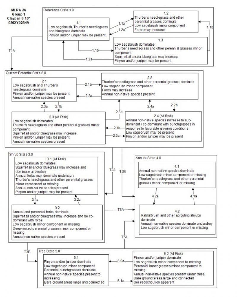
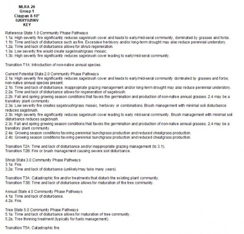
The Reference State 1.0 is a representative of the natural range of variability under pristine conditions. The reference state has three general community phases: a shrub-grass dominant phase, a perennial grass dominant phase and a shrub dominant phase. State dynamics are maintained by interactions between climatic patterns and disturbance regimes. Negative feedbacks enhance ecosystem resilience and contribute to the stability of the state. These include the presence of all structural and functional groups, low fine fuel loads, and retention of organic matter and nutrients. Plant community phase changes are primarily driven by fire, periodic drought and/or insect or disease attack.
Community 1.1 Community Phase 1.1
The reference plant community is dominated by low sagebrush, Thurber's needlegrass, and Sandberg's bluegrass. Potential vegetative composition is about 50% grasses, 10% forbs and 40% shrubs. Approximate ground cover (basal and crown) is about 20 to 30 percent.
Figure 5. Annual production by plant type (representative values) or group (midpoint values)
Table 5. Annual production by plant type
Plant type
Low (kg/hectare)
Representative value (kg/hectare)
High (kg/hectare)
Grass/Grasslike
112
168
224
Shrub/Vine
85
128
170
Forb
22
34
45
Tree
4
7
9
Total
223
337
448
Community 1.2 Community Phase 1.2
This community phase is characteristic of a post-disturbance, early/mid-seral community. Thurber’s needlegrass, squirreltail, and other perennial bunchgrasses dominate. Depending on fire severity patches of intact sagebrush may remain. Rabbitbrush and other sprouting shrubs may be sprouting. Perennial forbs may be a significant component for a number of years following fire.
Community 1.3 Community Phase 1.3
Sagebrush increases in the absence of disturbance. Decadent sagebrush dominates the overstory and the deep-rooted perennial bunchgrasses in the understory are reduced either from competition with shrubs and/or from herbivory.
Pathway 1.1a Community 1.1 to 1.2
Fire will decrease or eliminate the overstory of sagebrush and allow for the perennial bunchgrasses to dominate the site. Fires will typically be low severity resulting in a mosaic pattern due to low fuel loads. A fire following an unusually wet spring may be more severe and reduce sagebrush cover to trace amounts.
Pathway 1.1b Community 1.1 to 1.3
Time and lack of disturbance such as fire allows for sagebrush to increase and become decadent. Long-term drought, herbivory, or combinations of these will cause a decline in perennial bunchgrasses and fine fuels leading to a reduced fire frequency and allowing sagebrush to dominate the site.
Pathway 1.2a Community 1.2 to 1.1
Time and lack of disturbance will allow sagebrush to increase.
Pathway 1.3a Community 1.3 to 1.1
A low severity fire, herbivory or combinations will reduce the sagebrush overstory and create a sagebrush/grass mosaic.
Pathway 1.3b Community 1.3 to 1.2
Fire will decrease or eliminate the overstory of sagebrush and allow for the perennial bunchgrasses to dominate the site. Fires may be high severity in this community phase due to the dominance of sagebrush resulting in removal of overstory shrub community.
State 2 Current Potential State
The Current Potential State is similar to the Reference State 1.0. Ecological function has not changed, however the resiliency of the state has been reduced by the presence of invasive weeds. This state has four general community phases. These non-native species can be highly flammable, and promote fire where historically fire had been infrequent. Negative feedbacks enhance ecosystem resilience and contribute to the stability of the state. These feedbacks include the presence of all structural and functional groups, low fine fuel loads, and retention of organic matter and nutrients. Positive feedbacks decrease ecosystem resilience and stability of the state. These include the non-natives’ high seed output, persistent seed bank, rapid growth rate, ability to cross pollinate, and adaptations for seed dispersal.
Community 2.1 Community Phase 2.1
This community phase is similar to the Reference State Community Phase 1.1, with the presence of non-native species in trace amounts. Sagebrush, Thurber’s needlegrass and Sandberg bluegrass dominate the site. Forbs and other shrubs and grasses make up smaller components of this site.
Community 2.2 Community Phase 2.2
This community phase is characteristic of a post-disturbance, early to mid-seral community where annual non-native species are present. Sagebrush is present in trace amounts; perennial bunchgrasses dominate the site. Depending on fire severity patches of intact sagebrush may remain. Rabbitbrush maybe sprouting or dominant in the community. Perennial forbs may be a significant component for a number of years following fire. Annual non-native species are stable or increasing within the community.
Community 2.3 Community Phase 2.3 (at risk)
This community is at risk of crossing a threshold to another state. Sagebrush dominates the overstory and perennial bunchgrasses in the understory are reduced, either from competition with shrubs or from inappropriate grazing, or from both. Rabbitbrush may be a significant component. Squirreltail or Sandberg bluegrass may increase and become dominant. Annual non-native species may be stable or increasing due to lack of competition with perennial bunchgrasses. This site is susceptible to further degradation from grazing, drought, and fire.
Community 2.4 Community Phase 2.4 (At Risk)
This community is at risk of crossing into an annual state. Native bunchgrasses dominate; however, annual non-native species such as cheatgrass may be sub or co-dominant in the understory. Annual production and abundance of these annuals may increase drastically in years with heavy spring precipitation. Seeded species may be present. Sagebrush is a minor component. This site is susceptible to further degradation from grazing, drought, and fire.
Pathway 2.1a Community 2.1 to 2.2
Fire reduces the shrub overstory and allows for perennial bunchgrasses to dominate the site. Fires are typically low severity resulting in a mosaic pattern due to low fuel loads. A fire following an unusually wet spring or a change in management favoring an increase in fine fuels may be more severe and reduce sagebrush cover to trace amounts. Annual non-native species are likely to increase after fire.
Pathway 2.1b Community 2.1 to 2.3
Time and lack of disturbance allows for sagebrush to increase and become decadent. Long-term drought reduces fine fuels and leads to a reduced fire frequency, allowing sagebrush to dominate the site. Inappropriate grazing management reduces the perennial bunchgrass understory; conversely Sandberg bluegrass may increase in the understory depending on grazing management.
Pathway 2.2a Community 2.2 to 2.1
Time and lack of disturbance and/or grazing management that favors the establishment and growth of sagebrush allows the shrub component to recover. The establishment of low sagebrush can take many years.
Pathway 2.2b Community 2.2 to 2.4
Higher than normal spring precipitation favors annual non-native species such as cheatgrass. Non-native annual species will increase in production and density throughout the site. Perennial bunchgrasses may also increase in production.
Pathway 2.3b Community 2.3 to 2.2
Fire eliminates/reduces the overstory of sagebrush and allows for the understory perennial grasses to increase. Fires may be high severity in this community phase due to the dominance of sagebrush resulting in removal of overstory shrub community. Annual non-native species respond well to fire and may increase post burn.
Pathway 2.3c Community 2.3 to 2.4
Fall, winter, and spring precipitation and temperatures mediate the ability for annual grasses and perennial grasses to germinate and/or survive. Higher than normal spring precipitation creates high annual production of annual grasses (Bradley et al. 2016). Higher than normal spring precipitation favors annual non-native species such as cheatgrass. Non-native annual species increase in production and density throughout the site. Perennial bunchgrasses may also increase in production.
Pathway 2.4a Community 2.4 to 2.2
Fall, winter, and spring precipitation and temperatures mediate the ability for annual grasses and perennial grasses to germinate and/or survive. Depending on temperatures and precipitation in winter and spring, annual grass production may be reduced in favor of perennial bunchgrasses.
Pathway 2.4b Community 2.4 to 2.3
Rainfall patterns favoring perennial bunchgrasses. Less than normal spring precipitation followed by higher than normal summer precipitation will increase perennial bunchgrass production.
State 3 Shrub State
This state is a product of many years of heavy grazing during time periods harmful to perennial bunchgrasses. Squirreltail and/or Sandberg bluegrass increase with a reduction in deep rooted perennial bunchgrass competition and become the dominant grasses. Bare ground increases significantly. Annual forbs may be a significant or dominant component of the understory, resulting in bare ground after they senesce in the summer. Sagebrush dominates the overstory and rabbitbrush may be a significant component. Sagebrush cover exceeds site concept and may be decadent, reflecting stand maturity and lack of seedling establishment due to competition with mature plants. The shrub overstory and bluegrass understory dominate site resources such that soil water, nutrient capture, nutrient cycling and soil organic matter are temporally and spatially redistributed.
Community 3.1 Community Phase 3.1 (at risk)
Decadent sagebrush dominates the overstory. Rabbitbrush may be a significant component. Deep-rooted perennial bunchgrasses are present in trace amounts and may be absent from the community. Squirreltail, bluegrass species, and/or annual forbs dominate the understory. Bare ground may be significant. Pinyon and/or juniper may be encroaching but are not yet affecting understory vegetation.
Community 3.2 Community Phase 3.2
Annual and perennial forbs dominate the site (i.e. redstem stork’s bill (Erodium cicutarium), Hooker’s balsamroot (Balsamorhiza hookeri) and tapertip hawksbeard (Crepis acuminata)). Squirreltail and/or Sandberg bluegrass may increase and be co-dominant with forbs. Deep-rooted perennial bunchgrasses are a minor component or missing. Annual non-native species may be present but are not dominant. Trace amounts of sagebrush or rabbitbrush may be present.
Pathway 3.1a Community 3.1 to 3.2
Fire, heavy fall grazing causing mechanical damage to shrubs, and/or brush treatments with minimal soil disturbance, will greatly reduce the overstory shrubs to trace amounts and allow for Sandberg bluegrass to dominate the site.
Pathway 3.2a Community 3.2 to 3.1
Time and lack of disturbance and/or grazing management that favors the establishment and growth of sagebrush allows the shrub component to recover. The establishment of low and/or Lahontan sagebrush can take many years.
State 4 Annual State
An abiotic threshold has been crossed and state dynamics are driven by fire and time. The herbaceous understory is dominated by annual non-native species such as cheatgrass and mustards. Resiliency has declined and further degradation from fire facilitates a cheatgrass and sprouting shrub plant community. Fire return interval has shortened due to the dominance of cheatgrass in the understory and is a driver in site dynamics.
Community 4.1 Community Phase 4.1
Annuals nonnative species dominate. Sagebrush and perennial bunchgrasses may still be present in trace amounts. Surface erosion may increase with summer convection storms and would be verified through increased pedestalling of plants, rill formation or extensive water flow paths.
Community 4.2 Community Phase 4.2
Rabbitbrush is typically the dominant overstory shrub. Sagebrush is a minor component or missing. Annual non-native species dominate the understory.
Pathway 4.1a Community 4.1 to 4.2
Time and lack of disturbance allows rabbitbrush and/or other sprouting shrubs to recover after fire. Probability of sagebrush establishment is extremely low.
Pathway 4.2a Community 4.2 to 4.1
Fire reduces/eliminates overstory brush component and allows for annual non-native species to dominate the site.
State 5 Tree State
This state is characterized by a dominance of Utah juniper and/or singleleaf pinyon in the overstory. Big sagebrush and perennial bunchgrasses may still be present, but they are no longer controlling site resources. Soil moisture, soil nutrients and soil organic matter distribution and cycling have been spatially and temporally altered.
Community 5.1 Community Phase 5.1
Utah juniper and/or singleleaf pinyon dominates the overstory and site resources. Trees are actively growing with noticeable leader growth. Trace amounts of bunchgrasses may be found under tree canopies with trace amounts of Sandberg bluegrass and forbs in the interspaces. Sagebrush is stressed and dying. Annual non-native species are present under tree canopies. Bare ground interspaces are large and connected.
Community 5.2 Community Phase 5.2
Utah juniper and/or singleleaf pinyon dominates the site and tree leader growth is minimal; annual non-native species may be the dominant understory species and will typically be found under the tree canopies. Trace amounts of sagebrush may be present, however, dead skeletons will be more numerous than living sagebrush. Bunchgrass may or may not be present. Sandberg bluegrass or mat forming forbs may be present in trace amounts. Bare ground interspaces are large and connected. Soil redistribution is evident.
Pathway 5.1a Community 5.1 to 5.2
Time and lack of disturbance or management action allows Utah juniper and/or singleleaf pinyon to further mature and dominate site resources.
Pathway 5.2a Community 5.2 to 5.1
Tree thinning treatment, typically done for fuels management.
Transition T1A State 1 to 2
Trigger: This transition is caused by the introduction of non-native annual plants, such as cheatgrass, mustards, redstem stork’s bill (Erodium cicutarium), or bur buttercup (Ceratocephala testiculata).
Slow variables: Over time the annual non-native species will increase within the community.
Threshold: Any amount of introduced non-native species causes an immediate decrease in the resilience of the site. Annual non-native species cannot be easily removed from the system and have the potential to significantly alter disturbance regimes from their historic range of variation.
Transition T2A State 2 to 3
Trigger: To Community Phase 3.1: Inappropriate grazing will decrease or eliminate deep rooted perennial bunchgrasses and increase bare ground and shallow-rooted grazing-tolerant grasses. Shrub growth and establishment is favored under these conditions. To Community Phase 3.2: Severe fire in Community Phase 2.3 will remove sagebrush overstory, decrease perennial
bunchgrasses and enhance annual and perennial forb growth. Squirreltail and/or Sandberg bluegrass may increase. Annual non-native species are present.
Slow variables: Long term decrease in deep-rooted perennial grass density.
Threshold: Loss of deep-rooted perennial bunchgrasses changes nutrient cycling, nutrient redistribution, and reduces soil organic matter.
Transition T2B State 2 to 4
Trigger: Fire or soil disturbing treatment would transition to Community Phase 4.1.
Slow variables: Increased production and cover of non-native annual species.
Threshold: Loss of deep-rooted perennial bunchgrasses and shrubs changes temporal and spatial nutrient capture and cycling within the community.
Increased, continuous fine fuels modify the fire regime by increasing frequency, size and spatial variability of fires.
Transition T3A State 3 to 4
Trigger: Fire and/or treatments that disturb the soil and existing plant community.
Slow variables: Increased seed production (following a wet spring) and cover of annual non-native species.
Threshold: Increased, continuous fine fuels modify the fire regime by changing frequency, intensity, size and spatial variability of fires. Changes in plant community composition and spatial variability of vegetation due to the loss of perennial bunchgrasses and sagebrush truncate energy capture and impact the temporal and spatial aspects of nutrient cycling and distribution.
Transition T3B State 3 to 5
Trigger: Absence of disturbance over time allows Utah juniper and/or singleleaf pinyon dominance. Feedbacks and ecological processes: Trees increasingly dominate use of soil water, contributing to reductions in soil water availability to grasses and shrubs. Overtime, grasses and shrubs are outcompeted. Reduced herbaceous and shrub production slows soil organic matter inputs and increases soil erodibility through loss of cover and root structure.
Slow variables: Long-term increase in pinyon pine and/or Utah juniper density.
Threshold: Trees overtop sagebrush and out-compete shrubs for water and sunlight. Shrub skeletons exceed live shrubs in number. There is minimal recruitment of new shrub cohorts.
Transition T5A State 5 to 4
Trigger: Catastrophic fire causing a stand replacement event will transition Annual State 4.0. Inappropriate tree removal practices with soil disturbance will cause a transition to the Annual State 4.
Slow variables: Increased production and cover of non-native annual species under tree canopies.
Threshold: Closed tree canopy with non-native annual species dominant in the understory changes the intensity, size and spatial variability of fires. Changes in plant community composition and spatial variability of vegetation due to the loss of perennial bunchgrasses and sagebrush truncate energy capture and impact nutrient cycling and distribution.
Additional community tables
Table 6. Community 1.1 plant community composition
Livestock Interpretations:
This site is suited for livestock grazing during the spring, summer and fall. Grazing management should be keyed to Thurber's needlegrass, Sandberg's bluegrass, and Webber's needlegrass production. Thurber's needlegrass provides valuable forage for domestic livestock. Bluegrass is a widespread and drought resistant forage grass. It is one of the earliest grasses in the spring and is sought by domestic livestock. Weber's needlegrass is palatable to livestock and is grazed during the spring. Low sagebrush is considered a valuable browse plant for livestock during the spring, fall, and winter months.
Stocking rates vary over time depending upon season of use, climate variations, site, and previous and current management goals. A safe starting stocking rate is an estimated stocking rate that is fine tuned by the client by adaptive management through the year and from year to year.
Wildlife Interpretations:
Low sagebrush is considered a valuable browse plant during the spring, fall and winter months. In some areas it is of little value in winter due to heavy snow. Low sagebrush is an important food source for sage grouse throughout the year, especially between October and April. Mule deer utilize and sometimes prefer low sagebrush, particularly in winter and early spring. Sagebrush-grassland communities provide critical sage-grouse breeding and nesting habitats. Open Wyoming sagebrush communities are preferred nesting habitat. Meadows surrounded by sagebrush may be used as feeding and strutting grounds. Sagebrush is a crucial component of their diet year-round, and sage-grouse select sagebrush almost exclusively for cover. Leks are often located on low sagebrush sites, grassy openings, dry meadows, ridgetops, and disturbed sites. Sage-grouse prefer mountain big sagebrush and Wyoming big sagebrush communities to basin big sagebrush communities. Sandberg bluegrass is desirable for pronghorn antelope and mule deer in the spring and preferable in the spring, summer, and fall for elk and desirable as part of their winter range. Thuber's needlegrass and Webber's needlegrass are important forage species for several wildlife species.
Hydrological functions
Runoff is medium to very high. Rills and water flow patterns are rare, but a few can be expected on steeper slopes in areas subjected to summer convection storms or rapid spring snowmelt. Pedestals are rare with occurrence typically limited to area within water flow patterns. Frost heaving of shallow rooted plants should not be considered as normal condition. Gullies are rare in areas of this site that occur on stable landforms. Fine litter (foliage from grasses and annual & perennial forbs) is expected to move the distance of slope length during intense summer convection storms or rapid snowmelt events. Persistent litter (large woody material) will remain in place except during catastrophic events. Perennial herbaceous plants (especially deep-rooted bunchgrasses such as Thurber's needlegrass) slow runoff and increase infiltration. Shrub canopy and associated litter break raindrop impact and provide opportunity for snow catch and accumulation on site. Coarse textured surface soils allow medium to rapid infiltration.
Recreational uses
This site often occurs over broad expanses of the landscape. Its low stature and gray-green color creates a neutral surrounding which compliments anomalies in either the landscape or vegetation.
Wood products
Pinyon and juniper occur on this site as scattered individuals or in open stands under moist conditions, especially in and around drainages.
Other information
Low sagebrush can be successfully transplanted or seeded in restoration.
Interpreting Indicators of Rangeland Health is a qualitative assessment protocol used to
determine ecosystem condition based on benchmark characteristics described in the Reference Sheet. A suite of 17 (or
more) indicators are typically considered in an assessment. The ecological site(s) representative of an assessment
location must be known prior to applying the protocol and must be verified based on soils and climate. Current plant
community cannot be used to identify the ecological site.
Author(s)/participant(s)
GK Brackley
Contact for lead author
State Rangeland Management Specialist
Date
09/01/1992
Approved by
Kendra Moseley
Approval date
Composition (Indicators 10 and 12) based on
Annual Production
Indicators
Number and extent of rills:
Rills are rare. A few can be expected on steeper slopes in areas subjected to summer convection storms or rapid spring snowmelt.
Presence of water flow patterns:
Water flow patterns are rare but can be expected in areas subjected to summer convection storms or rapid snowmelt.
Number and height of erosional pedestals or terracettes:
Pedestals are rare with occurrence typically limited to area within water flow patterns. Frost heaving of shallow rooted plants should not be considered as normal condition.
Bare ground from Ecological Site Description or other studies (rock, litter, lichen, moss, plant canopy are
not bare ground):
Bare Ground 35-50% depending on amount of surface rock fragments.
Number of gullies and erosion associated with gullies:
None
Extent of wind scoured, blowouts and/or depositional areas:
None
Amount of litter movement (describe size and distance expected to travel):
Fine litter (foliage from grasses and annual & perennial forbs) is expected to move the distance of slope length during intense summer convection storms or rapid snowmelt events. Persistent litter (large woody material) will remain in place except during large rainfall events.
Soil surface (top few mm) resistance to erosion (stability values are averages - most sites will show a range
of values):
Soil stability values should be 3 to 6 on most soil textures found on this site. (To be field tested.)
Soil surface structure and SOM content (include type of structure and A-horizon color and thickness):
Surface structure is typically thin to thick platy or fine granualr. Soil surface colors are grays and the soils are typified by an ochric epipedon. Organic carbon of the surface 2 to 3 inches is typically 1 to 1.5 percent dropping off quickly below. Organic matter content can be more or less depending on micro-topography.
Effect of community phase composition (relative proportion of different functional groups) and spatial
distribution on infiltration and runoff:
Perennial herbaceous plants (especially deep-rooted bunchgrasses such as Thurber needlegrass) slow runoff and increase infiltration. Shrub canopy and associated litter break raindrop impact and provide opportunity for snow catch and accumulation on site. Coarse textured surface soils allow medium to rapid infiltration.
Presence and thickness of compaction layer (usually none; describe soil profile features which may be
mistaken for compaction on this site):
Compacted layers are none. Platy or massive sub-surface horizons, subsoil argillic horizons or duripans are not to be interpreted as compacted.
Functional/Structural Groups (list in order of descending dominance by above-ground annual-production or live foliar
cover using symbols: >>, >, = to indicate much greater than, greater than, and equal to):
Amount of plant mortality and decadence (include which functional groups are expected to show mortality or
decadence):
Dead branches within individual shrubs are common and standing dead shrub canopy material may be as much as 35% of total woody canopy; some of the mature bunchgrasses (<30%) have dead centers.
Average percent litter cover (%) and depth ( in):
Under shrubs and between plant interspaces 20-30% and depth (± ¼ in.)
Expected annual annual-production (this is TOTAL above-ground annual-production, not just forage annual-production):
For normal or average growing season, ± 300 lbs/ac; Spring moisture significantly affects total production. Favorable production ± 400 lbs/ac; unfavorable years ± 200 lbs/ac.
Potential invasive (including noxious) species (native and non-native). List species which BOTH characterize
degraded states and have the potential to become a dominant or co-dominant species on the ecological site if
their future establishment and growth is not actively controlled by management interventions. Species that become
dominant for only one to several years (e.g., short-term response to drought or wildfire) are not invasive
plants. Note that unlike other indicators, we are describing what is NOT expected in the reference state for the
ecological site:
Potential invaders on this site include cheatgrass, medusahead, Russian thistle and annual mustards.
Perennial plant reproductive capability:
All functional groups should reproduce in average (or normal) and above average growing season years. Little growth or reproduction occurs in drought years.
The Ecosystem Dynamics Interpretive Tool is an information system framework developed by the USDA-ARS Jornada Experimental Range, USDA Natural Resources Conservation Service, and New Mexico State University.
Click on box and path labels to scroll to the respective text.