Ecological dynamics
As ecological condition declines, Lahonton sagebrush, shadscale, rabbitbrush, and bottlebrush squirreltail, increase as desert needlegrass and Indian ricegrass decrease. Cheatgrass is most likely to invade this site.
Fire Ecology:
The mean fire return intervals for Lahontan sagebrush communities have been estimated to be from 35 to over 100 years. Fire most often occurs during wet years with high forage production. Lahontan sagebrush is very susceptible to fire damage. Lahontan sagebrush is usually killed by fire and does not re-sprout. The recovery in burned areas is usually via small, light, wind-dispersed seed for all low sagebrush subspecies. Partially injured Lahontan sagebrush may re-grow from living branches, but sprouting does not occur.
Indian ricegrass can be killed by fire, depending on severity and season of burn. Indian ricegrass reestablishes on burned sites through seed dispersed from adjacent unburned areas. Desert needlegrass has persistent dead leaf bases, which make it susceptible to burning. Fire removes the accumulation; a rapid, cool fire will not burn deep into the root crown.
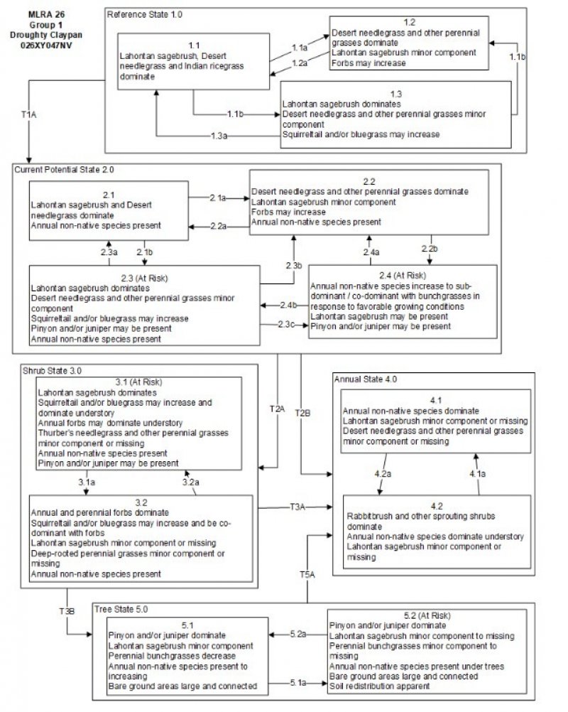
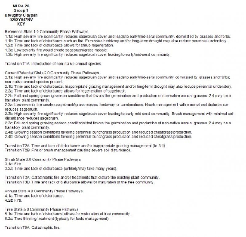
Reference State 1.0: The Reference State 1.0 is a representative of the natural range of variability under pristine conditions. The reference state has three general community phases: a shrub-grass dominant phase, a perennial grass dominant phase and a shrub dominant phase. State dynamics are maintained by interactions between climatic patterns and disturbance regimes. Negative feedbacks enhance ecosystem resilience and contribute to the stability of the state. These include the presence of all structural and functional groups, low fine fuel loads, and retention of organic matter and nutrients. Plant community phase changes are primarily driven by fire, periodic drought and/or insect or disease attack.
Community Phase 1.1: This community is dominated by Lahontan sagebrush, Thurber’s needlegrass and Sandberg bluegrass. Forbs and other grasses make up smaller components. Pinyon and/or juniper may be present.
Community Phase Pathway 1.1a, from Phase 1.1 to 1.2: Fire will decrease or eliminate the overstory of sagebrush and allow for the perennial bunchgrasses to dominate the site. Fires will typically be low severity resulting in a mosaic pattern due to low fuel loads. A fire following an unusually wet spring may be more severe and reduce sagebrush cover to trace amounts.
Community Phase Pathway 1.1b, from Phase 1.1 to 1.3: Time and lack of disturbance such as fire allows for sagebrush to increase and become decadent. Long-term drought, herbivory, or combinations of these will cause a decline in perennial bunchgrasses and fine fuels leading to a reduced fire frequency and allowing sagebrush to dominate the site.
Community Phase 1.2: This community phase is characteristic of a post-disturbance, early/mid-seral community. Thurber’s needlegrass, squirreltail, and other perennial bunchgrasses dominate. Depending on fire severity patches of intact sagebrush may remain. Rabbitbrush and other sprouting shrubs may be sprouting. Perennial forbs may be a significant component for a number of years following fire.
Community Phase Pathway 1.2a, from Phase 1.2 to 1.1: Time and lack of disturbance will allow sagebrush to increase.
Community Phase 1.3: Sagebrush increases in the absence of disturbance. Decadent sagebrush dominates the overstory and the deep-rooted perennial bunchgrasses in the understory are reduced either from competition with shrubs and/or from herbivory.
Community Phase Pathway 1.3a, from Phase 1.3 to 1.1: A low severity fire, herbivory or combinations will reduce the sagebrush overstory and create a sagebrush/grass mosaic.
Community Phase Pathway 1.3b, from Phase 1.3 to 1.2: Fire will decrease or eliminate the overstory of sagebrush and allow for the perennial bunchgrasses to dominate the site. Fires may be high severity in this community phase due to the dominance of sagebrush resulting in removal of overstory shrub community.
T1A: Transition from the Reference State 1.0 to Current Potential State 2.0
Trigger: This transition is caused by the introduction of non-native annual plants, such as cheatgrass, mustards, redstem stork’s bill (Erodium cicutarium), or bur buttercup (Ceratocephala testiculata).
Slow variables: Over time the annual non-native species will increase within the community.
Threshold: Any amount of introduced non-native species causes an immediate decrease in the resilience of the site. Annual non-native species cannot be easily removed from the system and have the potential to significantly alter disturbance regimes from their historic range of variation.
Current Potential State 2.0: This state is similar to the Reference State 1.0. Ecological function has not changed, however the resiliency of the state has been reduced by the presence of invasive weeds. This state has four general community phases. These non-native species can be highly flammable, and promote fire where historically fire had been infrequent. Negative feedbacks enhance ecosystem resilience and contribute to the stability of the state. These feedbacks include the presence of all structural and functional groups, low fine fuel loads, and retention of organic matter and nutrients. Positive feedbacks decrease ecosystem resilience and stability of the state. These include the non-natives’ high seed output, persistent seed bank, rapid growth rate, ability to cross pollinate, and adaptations for seed dispersal.
Community Phase 2.1:This community phase is similar to the Reference State Community Phase 1.1, with the presence of non-native species in trace amounts. Sagebrush, Thurber’s needlegrass and Sandberg bluegrass dominate the site. Forbs and other shrubs and grasses make up smaller components of this site.
Community Phase Pathway 2.1a, from Phase 2.1 to 2.2: Fire reduces the shrub overstory and allows for perennial bunchgrasses to dominate the site. Fires are typically low severity resulting in a mosaic pattern due to low fuel loads. A fire following an unusually wet spring or a change in management favoring an increase in fine fuels may be more severe and reduce sagebrush cover to trace amounts. Annual non-native species are likely to increase after fire.
Community Phase Pathway 2.1b, from Phase 2.1 to 2.3: Time and lack of disturbance allows for sagebrush to increase and become decadent. Long-term drought reduces fine fuels and leads to a reduced fire frequency, allowing sagebrush to dominate the site. Inappropriate grazing management reduces the perennial bunchgrass understory; conversely Sandberg bluegrass may increase in the understory depending on grazing management.
Community Phase 2.2:This community phase is characteristic of a post-disturbance, early to mid-seral community where annual non-native species are present. Sagebrush is present in trace amounts; perennial bunchgrasses dominate the site. Depending on fire severity patches of intact sagebrush may remain. Rabbitbrush maybe sprouting or dominant in the community. Perennial forbs may be a significant component for a number of years following fire. Annual non-native species are stable or increasing within the community.
Community Phase Pathway 2.2a, from Phase 2.2 to 2.1: Time and lack of disturbance and/or grazing management that favors the establishment and growth of sagebrush allows the shrub component to recover. The establishment of low sagebrush can take many years.
Community Phase Pathway 2.2b, from Phase 2.2 to 2.4: Higher than normal spring precipitation favors annual non-native species such as cheatgrass. Non-native annual species will increase in production and density throughout the site. Perennial bunchgrasses may also increase in production.
Community Phase 2.3 (At Risk):This community is at risk of crossing a threshold to another state. Sagebrush dominates the overstory and perennial bunchgrasses in the understory are reduced, either from competition with shrubs or from inappropriate grazing, or from both. Rabbitbrush may be a significant component. Squirreltail or Sandberg bluegrass may increase and become dominant. Annual non-native species may be stable or increasing due to lack of competition with perennial bunchgrasses. This site is susceptible to further degradation from grazing, drought, and fire.
Community Phase Pathway 2.3a, from Phase 2.3 to 2.1: A change in grazing management that reduces shrubs will allow for the perennial bunchgrasses in the understory to increase. Heavy late-fall or winter grazing may cause mechanical damage and subsequent death to sagebrush, facilitating an increase in the herbaceous understory. Low and Lahontan sagebrush are palatable shrub species and can decrease with increased grazing pressure. Brush treatments with minimal soil disturbance will also decrease sagebrush and release the perennial understory. A low severity fire would decrease the overstory of sagebrush and allow for the understory perennial grasses to increase. Due to low fuel loads in this state, fires will likely be small creating a mosaic pattern. Annual non-native species are present and may increase in the community.
Community Phase Pathway 2.3b, from Phase 2.3 to 2.2:Fire eliminates/reduces the overstory of sagebrush and allows for the understory perennial grasses to increase. Fires may be high severity in this community phase due to the dominance of sagebrush resulting in removal of overstory shrub community. Annual non-native species respond well to fire and may increase post burn.
Community Phase Pathway 2.3c, from Phase 2.3 to 2.4:Fall, winter, and spring precipitation and temperatures mediate the ability for annual grasses and perennial grasses to germinate and/or survive. Higher than normal spring precipitation creates high annual production of annual grasses (Bradley et al. 2016). Higher than normal spring precipitation favors annual non-native species such as cheatgrass. Non-native annual species increase in production and density throughout the site. Perennial bunchgrasses may also increase in production.
Community Phase 2.4 (At Risk): This community is at risk of crossing into an annual state. Native bunchgrasses dominate; however, annual non-native species such as cheatgrass may be sub or co-dominant in the understory. Annual production and abundance of these annuals may increase drastically in years with heavy spring precipitation. Seeded species may be present. Sagebrush is a minor component. This site is susceptible to further degradation from grazing, drought, and fire.
Community Phase Pathway 2.4a, from Phase 2.4 to 2.2: Fall, winter, and spring precipitation and temperatures mediate the ability for annual grasses and perennial grasses to germinate and/or survive. Depending on temperatures and precipitation in winter and spring, annual grass production may be reduced in favor of perennial bunchgrasses.
Community Phase Pathway 2.4b, from Phase 2.4 to 2.3: Rainfall patterns favoring perennial bunchgrasses. Less than normal spring precipitation followed by higher than normal summer precipitation will increase perennial bunchgrass production.
T2A: Transition from Current Potential State 2.0 to Shrub State 3.0:
Trigger: To Community Phase 3.1: Inappropriate grazing will decrease or eliminate deep rooted perennial bunchgrasses and increase bare ground and shallow-rooted grazing-tolerant grasses. Shrub growth and establishment is favored under these conditions. To Community Phase 3.2: Severe fire in Community Phase 2.3 will remove sagebrush overstory, decrease perennial bunchgrasses and enhance annual and perennial forb growth. Squirreltail and/or Sandberg bluegrass may increase. Annual non-native species are present.
Slow variables: Long term decrease in deep-rooted perennial grass density.
Threshold: Loss of deep-rooted perennial bunchgrasses changes nutrient cycling, nutrient redistribution, and reduces soil organic matter.
T2B: Transition from Current Potential State 2.0 to Annual State 4.0:
Trigger: Fire or soil disturbing treatment would transition to Community Phase 4.1.
Slow variables: Increased production and cover of non-native annual species.
Threshold: Loss of deep-rooted perennial bunchgrasses and shrubs changes temporal and spatial nutrient capture and cycling within the community. Increased, continuous fine fuels modify the fire regime by increasing frequency, size and spatial variability of fires.
Shrub State 3.0: This state is a product of many years of heavy grazing during time periods harmful to perennial bunchgrasses. Squirreltail and/or Sandberg bluegrass increase with a reduction in deep rooted perennial bunchgrass competition and become the dominant grasses. Bare ground increases significantly. Annual forbs may be a significant or dominant component of the understory, resulting in bare ground after they senesce in the summer. Sagebrush dominates the overstory and rabbitbrush may be a significant component. Sagebrush cover exceeds site concept and may be decadent, reflecting stand maturity and lack of seedling establishment due to competition with mature plants. The shrub overstory and bluegrass understory dominate site resources such that soil water, nutrient capture, nutrient cycling and soil organic matter are temporally and spatially redistributed.
Community Phase 3.1 (At Risk): Decadent sagebrush dominates the overstory. Rabbitbrush may be a significant component. Deep-rooted perennial bunchgrasses are present in trace amounts and may be absent from the community. Squirreltail, bluegrass species, and/or annual forbs dominate the understory. Bare ground may be significant. Pinyon and/or juniper may be encroaching but are not yet affecting understory vegetation.
Community Phase Pathway 3.1a, from Phase 3.1 to 3.2: Fire, heavy fall grazing causing mechanical damage to shrubs, and/or brush treatments with minimal soil disturbance, will greatly reduce the overstory shrubs to trace amounts and allow for Sandberg bluegrass to dominate the site.
Community Phase 3.2: Annual and perennial forbs dominate the site (i.e. redstem stork’s bill (Erodium cicutarium), Hooker’s balsamroot (Balsamorhiza hookeri) and tapertip hawksbeard (Crepis acuminata)). Squirreltail and/or Sandberg bluegrass may increase and be co-dominant with forbs. Deep-rooted perennial bunchgrasses are a minor component or missing. Annual non-native species may be present but are not dominant. Trace amounts of sagebrush or rabbitbrush may be present.
Community Phase Pathway 3.2a, from Phase 3.2 to 3.1: Time and lack of disturbance and/or grazing management that favors the establishment and growth of sagebrush allows the shrub component to recover. The establishment of low and/or Lahontan sagebrush can take many years.
T3A: Transition from Shrub State 3.0 to Annual State 4.0:Trigger: Fire and/or treatments that disturb the soil and existing plant community.
Slow variables: Increased seed production (following a wet spring) and cover of annual non-native species.
Threshold: Increased, continuous fine fuels modify the fire regime by changing frequency, intensity, size and spatial variability of fires. Changes in plant community composition and spatial variability of vegetation due to the loss of perennial bunchgrasses and sagebrush truncate energy capture and impact the temporal and spatial aspects of nutrient cycling and distribution.
T3B: Transition from Shrub State 3.0 to Tree State 5.0:Trigger: Absence of disturbance over time allows Utah juniper and/or singleleaf pinyon dominance. Feedbacks and ecological processes: Trees increasingly dominate use of soil water, contributing to reductions in soil water availability to grasses and shrubs. Overtime, grasses and shrubs are outcompeted. Reduced herbaceous and shrub production slows soil organic matter inputs and increases soil erodibility through loss of cover and root structure.
Slow variables: Long-term increase in pinyon pine and/or Utah juniper density.
Threshold: Trees overtop sagebrush and out-compete shrubs for water and sunlight. Shrub skeletons exceed live shrubs in number. There is minimal recruitment of new shrub cohorts.
Annual State 4.0: An abiotic threshold has been crossed and state dynamics are driven by fire and time. The herbaceous understory is dominated by annual non-native species such as cheatgrass and mustards. Resiliency has declined and further degradation from fire facilitates a cheatgrass and sprouting shrub plant community. Fire return interval has shortened due to the dominance of cheatgrass in the understory and is a driver in site dynamics.
Community Phase 4.1: Annuals nonnative species dominate. Sagebrush and perennial bunchgrasses may still be present in trace amounts. Surface erosion may increase with summer convection storms and would be verified through increased pedestalling of plants, rill formation or extensive water flow paths.
Community Phase Pathway 4.1a, from Phase 4.1 to 4.2: Time and lack of disturbance allows rabbitbrush and/or other sprouting shrubs to recover after fire. Probability of sagebrush establishment is extremely low.
Community Phase 4.2: Rabbitbrush is typically the dominant overstory shrub. Sagebrush is a minor component or missing. Annual non-native species dominate the understory.
Community Phase Pathway 4.2a, from Phase 4.2 to 4.1: Fire reduces/eliminates overstory brush component and allows for annual non-native species to dominate the site.
Tree State 5.0: This state is characterized by a dominance of Utah juniper and/or singleleaf pinyon in the overstory. Big sagebrush and perennial bunchgrasses may still be present, but they are no longer controlling site resources. Soil moisture, soil nutrients and soil organic matter distribution and cycling have been spatially and temporally altered.
Community Phase 5.1: Utah juniper and/or singleleaf pinyon dominates the overstory and site resources. Trees are actively growing with noticeable leader growth. Trace amounts of bunchgrasses may be found under tree canopies with trace amounts of Sandberg bluegrass and forbs in the interspaces. Sagebrush is stressed and dying. Annual non-native species are present under tree canopies. Bare ground interspaces are large and connected.
Community Phase Pathway 5.1a, from Phase 5.1 to 5.2: Time and lack of disturbance or management action allows Utah juniper and/or singleleaf pinyon to further mature and dominate site resources.
Community Phase 5.2: Utah juniper and/or singleleaf pinyon dominates the site and tree leader growth is minimal; annual non-native species may be the dominant understory species and will typically be found under the tree canopies. Trace amounts of sagebrush may be present, however, dead skeletons will be more numerous than living sagebrush. Bunchgrass may or may not be present. Sandberg bluegrass or mat forming forbs may be present in trace amounts. Bare ground interspaces are large and connected. Soil redistribution is evident.
T5A: Transition from Tree State 5.0 to Annual State 4.0:Trigger: Catastrophic fire causing a stand replacement event will transition Annual State 4.0. Inappropriate tree removal practices with soil disturbance will cause a transition to the Annual State 4.
Slow variables: Increased production and cover of non-native annual species under tree canopies.
Threshold: Closed tree canopy with non-native annual species dominant in the understory changes the intensity, size and spatial variability of fires. Changes in plant community composition and spatial variability of vegetation due to the loss of perennial bunchgrasses and sagebrush truncate energy capture and impact nutrient cycling and distribution.
State 1
Reference Plant Community
Community 1.1
Reference Plant Community
The reference plant community is dominated by Lahontan sagebrush and desert needlegrass. Potential vegetative composition is about 40% grasses, 5% forbs and 55% shrubs.
Table 5. Annual production by plant type
| Plant type |
Low
(lb/acre) |
Representative value
(lb/acre) |
High
(lb/acre) |
| Shrub/Vine |
82 |
110 |
165 |
| Grass/Grasslike |
60 |
80 |
120 |
| Forb |
8 |
10 |
15 |
| Total |
150 |
200 |
300 |