Natural Resources
Conservation Service
Ecological site R029XY160NV
LIMESTONE SLOPE 8-10 P.Z.
Accessed: 12/21/2025
General information
Provisional. A provisional ecological site description has undergone quality control and quality assurance review. It contains a working state and transition model and enough information to identify the ecological site.

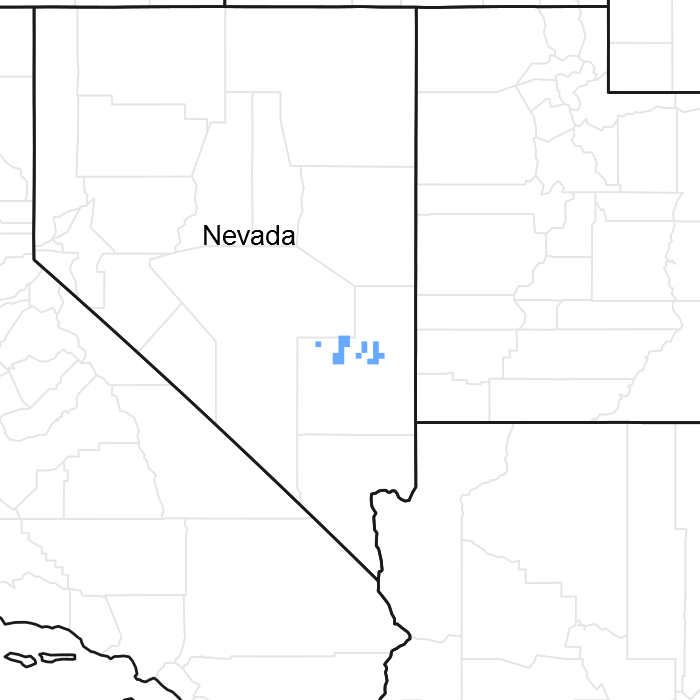
Figure 1. Mapped extent
Areas shown in blue indicate the maximum mapped extent of this ecological site. Other ecological sites likely occur within the highlighted areas. It is also possible for this ecological site to occur outside of highlighted areas if detailed soil survey has not been completed or recently updated.
Associated sites
| R029XY014NV |
SHALLOW CALCAREOUS SLOPE 8-12 P.Z. |
|---|---|
| R029XY040NV |
LIMESTONE HILL |
Similar sites
| R029XY045NV |
STONY CALCAREOUS SLOPE 8-12 P.Z. ARNO4 dominant shrub; more productive site |
|---|---|
| R029XY073NV |
BOULDERY SLOPE 8-12 P.Z. ARTR2 dominant shrub. |
| R029XY040NV |
LIMESTONE HILL CEIN7 dominant shrub. |
Table 1. Dominant plant species
| Tree |
Not specified |
|---|---|
| Shrub |
(1) Purshia stansburiana |
| Herbaceous |
(1) Achnatherum speciosum |
Physiographic features
This site occurs on summits and sideslopes of hills and lower mountains on all aspects. Slopes range from 15 to 75 percent, but slope gradients of 30 to 50 percent are typical. Elevations are 4900 to 6200 feet.
Table 2. Representative physiographic features
| Landforms |
(1)
Mountain slope
(2) Hill |
|---|---|
| Elevation | 4,900 – 6,200 ft |
| Slope | 15 – 75% |
| Aspect | N, S, W |
Climatic features
The climate is semi-arid charecterized by cold, moist winters and warm, moist summers. Precipitation is distributed evenly through out the year with June being the driest month. Average annual precipitation is 8 to 10 inches. Mean annual air temperature is 50 to 54 degrees F. The average growing season is 100 to 130 days.
Table 3. Representative climatic features
| Frost-free period (average) | 130 days |
|---|---|
| Freeze-free period (average) | 0 days |
| Precipitation total (average) | 10 in |
Figure 2. Monthly average minimum and maximum temperature
Influencing water features
There are no influencing water features associated with this site.
Soil features
The soils in this site are very shallow to shallow and well drained. These soils formed in residuum and colluvium form limestone and dolomite. The profile usually contains 35 to 50 percent rock fragments. High amounts of rock fragments occur on the soil surface. Rock fragments on the soil surface provide a stabilizing effect on surface erosion potential. Surface runoff is high to very high, available water holding capacity is very low to low and water intake rates are moderate.
Table 4. Representative soil features
| Surface texture |
(1) Extremely cobbly loam |
|---|---|
| Family particle size |
(1) Loamy |
| Drainage class | Well drained |
| Permeability class | Moderate |
| Soil depth | 6 – 14 in |
| Surface fragment cover <=3" | 35 – 50% |
| Surface fragment cover >3" | 10 – 25% |
| Available water capacity (0-40in) |
1 – 3 in |
| Calcium carbonate equivalent (0-40in) |
Not specified |
| Electrical conductivity (0-40in) |
Not specified |
| Sodium adsorption ratio (0-40in) |
Not specified |
| Soil reaction (1:1 water) (0-40in) |
8.3 – 8.5 |
| Subsurface fragment volume <=3" (Depth not specified) |
10 – 25% |
| Subsurface fragment volume >3" (Depth not specified) |
5 – 15% |
Ecological dynamics
Where management results in abusive livestock and/or feral horse use; Douglas’ rabbitbrush, horsebrush, snakeweed and galleta will increase, while desert needlegrass and cliffrose will decrease. Cheatgrass is a species likely to invade this site.
Fire Ecology:
Historic fire return intervals for sagebrush communities in which Stansbury Cliffrose occurs range from 30 to 70 years. Fire can have a variable effect on Stansbury cliffrose. Resprouting of Stansbury cliffrose varies depending on severity of fire. Black sagebrush is readily killed by all fire intensities. Desert needlegrass survival after fire is also dependent on severity and season of fire, but desert needlegrass will usually survive.
State and transition model

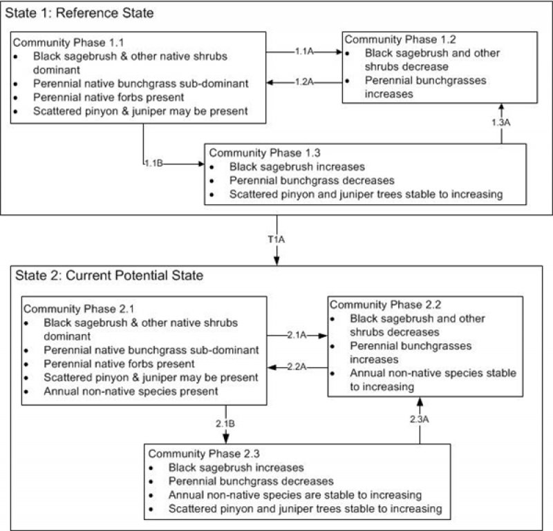
Figure 3. DRAFT STM

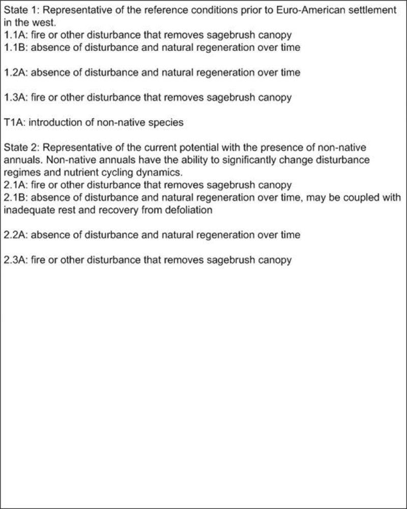
Figure 4. DRAFT STM LEGEND
More interactive model formats are also available.
View Interactive Models
More interactive model formats are also available.
View Interactive Models
Click on state and transition labels to scroll to the respective text
Ecosystem states
State 1 submodel, plant communities
State 1
Reference State
Community 1.1
Reference Plant Community
The reference plant community is dominated by Stansbury’s cliffrose, desert needlegrass and galleta. Other important species are threeawn, bluegrass, and Nevada ephedra. Potential vegetative composition is about 20% grasses, 5% forbs and 75% shrubs. Approximate ground cover (basal and crown) is 10 to 20 percent.
Figure 5. Annual production by plant type (representative values) or group (midpoint values)
Table 5. Annual production by plant type
| Plant type | Low (lb/acre) |
Representative value (lb/acre) |
High (lb/acre) |
|---|---|---|---|
| Shrub/Vine | 140 | 245 | 350 |
| Grass/Grasslike | 40 | 70 | 100 |
| Forb | 20 | 35 | 50 |
| Total | 200 | 350 | 500 |
State 2
Current Potential State
Additional community tables
Table 6. Community 1.1 plant community composition
| Group | Common name | Symbol | Scientific name | Annual production (lb/acre) | Foliar cover (%) | |
|---|---|---|---|---|---|---|
|
Grass/Grasslike
|
||||||
| 1 | Primary Perennial Grasses | 25–71 | ||||
| desert needlegrass | ACSP12 | Achnatherum speciosum | 18–53 | – | ||
| James' galleta | PLJA | Pleuraphis jamesii | 7–18 | – | ||
| 2 | Secondary Perennial Grasses | 12–42 | ||||
| King's eyelashgrass | BLKI | Blepharidachne kingii | 2–7 | – | ||
|
Forb
|
||||||
| 3 | Perennial | 7–28 | ||||
| globemallow | SPHAE | Sphaeralcea | 2–7 | – | ||
| 4 | Annual | 1–11 | ||||
| Indian ricegrass | ACHY | Achnatherum hymenoides | 2–7 | – | ||
| threeawn | ARIST | Aristida | 2–7 | – | ||
| King's eyelashgrass | BLKI | Blepharidachne kingii | 2–7 | – | ||
| blue grama | BOGR2 | Bouteloua gracilis | 2–7 | – | ||
| squirreltail | ELEL5 | Elymus elymoides | 2–7 | – | ||
| Sandberg bluegrass | POSE | Poa secunda | 2–7 | – | ||
| desert globemallow | SPAM2 | Sphaeralcea ambigua | 1–5 | – | ||
|
Shrub/Vine
|
||||||
| 5 | Primary Shrubs | 189–291 | ||||
| Stansbury cliffrose | PUST | Purshia stansburiana | 158–210 | – | ||
| black sagebrush | ARNO4 | Artemisia nova | 18–53 | – | ||
| mormon tea | EPVI | Ephedra viridis | 7–28 | – | ||
| spiny greasebush | GLSP | Glossopetalon spinescens | 4–18 | – | ||
| 6 | Secondary Shrubs | 28–77 | ||||
| yellow rabbitbrush | CHVI8 | Chrysothamnus viscidiflorus | 4–11 | – | ||
| cottontop cactus | ECPO2 | Echinocactus polycephalus | 4–11 | – | ||
| Heermann's buckwheat | ERHE | Eriogonum heermannii | 4–11 | – | ||
| pricklypear | OPUNT | Opuntia | 4–11 | – | ||
| desert almond | PRFA | Prunus fasciculata | 4–11 | – | ||
| horsebrush | TETRA3 | Tetradymia | 4–11 | – | ||
| banana yucca | YUBA | Yucca baccata | 4–11 | – | ||
Interpretations
Animal community
Livestock Interpretations:
This site has limited value for livestock grazing, due to the steep slopes and stony surface. Grazing management should be keyed to Desert needlegrass and Stansburry cliffrose Production. Desert needlegrass produces considerable basal foliage and is good forage while young. Young desert needlegrass is palatable to all classes of livestock. Mature herbage is moderately grazed by horses and cattle but rarely grazed by sheep. Stansbury cliffrose is an important browse species for livestock, especially in the winter.
Stocking rates vary over time depending upon season of use, climate variations, site, and previous and current management goals. A safe starting stocking rate is an estimated stocking rate that is fine tuned by the client by adaptive management through the year and from year to year.
Wildlife Interpretations:
Stansbury cliffrose is an important browse species for mule deer, pronghorn, game birds, and songbirds. Wild ungulates use it heavily in winter. Desert needlegrass is an important forage species for several wildlife species.
Hydrological functions
Runoff is high to very high. Permeability is moderate.
Recreational uses
Aesthetic value is derived from the diverse floral and faunal composition and the colorful flowering of wild flowers and shrubs during the spring and early summer. This site offers rewarding opportunities to photographers and for nature study. This site is used for hiking and has potential for upland and big game hunting.
Other products
Triterpenoids extracted from Stansbury cliffrose have been shown to have inhibitory effects on HIV and Epstein-Barr virus. Native Americans used the inner bark for making clothing and ropes, and the branches for making arrows.
Other information
Stansbury cliffrose is recommended for wildlife, roadside, construction, and mine spoils plantings; and for restoring pinyon-juniper woodland, mountain brushland, basin big sagebrush grassland, black sagebrush, and black greasewood communities. It can be established on disturbed seedbeds by broadcast seeding, drill seeding, or transplanting. Fall or winter seeding is recommended. Desert needlegrass seeds are easily germinated and have potential for commercial use. Desert needlegrass may be used for groundcover in areas of light disturbance, but it is susceptible to excessive trampling.
Supporting information
Type locality
| Location 1: Lincoln County, NV | |
|---|---|
| Township/Range/Section | T1N R65E S33 |
| UTM zone | N |
| UTM northing | 4197219 |
| UTM easting | 703122 |
| General legal description | Approximately 2 to 3 miles east of Ely Springs Ranch, Ely Springs Ranch, Lincoln County, Nevada. |
Other references
Fire Effects Information System (Online; http://www.fs.fed.us/database/feis/plants/)
Hood, Sharon M.; Miller, Melanie, editors. 2007. Fire Ecology and Management of the Major Ecosystems of Southern Utah. Gen. Tech. Rep. RMRS-GTR-202. Fort Collins, CO: U.S. Department of agriculture, Forest Service, Rocky Mountain Research Station. 110p.
USDA-NRCS Plants Database (Online; http://www.plants.usda.gov)
Contributors
C. Jasmine / J.Mosely
CMJ
Rangeland health reference sheet
Interpreting Indicators of Rangeland Health is a qualitative assessment protocol used to determine ecosystem condition based on benchmark characteristics described in the Reference Sheet. A suite of 17 (or more) indicators are typically considered in an assessment. The ecological site(s) representative of an assessment location must be known prior to applying the protocol and must be verified based on soils and climate. Current plant community cannot be used to identify the ecological site.
| Author(s)/participant(s) | |
|---|---|
| Contact for lead author | |
| Date | |
| Approved by | |
| Approval date | |
| Composition (Indicators 10 and 12) based on | Annual Production |
Indicators
-
Number and extent of rills:
-
Presence of water flow patterns:
-
Number and height of erosional pedestals or terracettes:
-
Bare ground from Ecological Site Description or other studies (rock, litter, lichen, moss, plant canopy are not bare ground):
-
Number of gullies and erosion associated with gullies:
-
Extent of wind scoured, blowouts and/or depositional areas:
-
Amount of litter movement (describe size and distance expected to travel):
-
Soil surface (top few mm) resistance to erosion (stability values are averages - most sites will show a range of values):
-
Soil surface structure and SOM content (include type of structure and A-horizon color and thickness):
-
Effect of community phase composition (relative proportion of different functional groups) and spatial distribution on infiltration and runoff:
-
Presence and thickness of compaction layer (usually none; describe soil profile features which may be mistaken for compaction on this site):
-
Functional/Structural Groups (list in order of descending dominance by above-ground annual-production or live foliar cover using symbols: >>, >, = to indicate much greater than, greater than, and equal to):
Dominant:
Sub-dominant:
Other:
Additional:
-
Amount of plant mortality and decadence (include which functional groups are expected to show mortality or decadence):
-
Average percent litter cover (%) and depth ( in):
-
Expected annual annual-production (this is TOTAL above-ground annual-production, not just forage annual-production):
-
Potential invasive (including noxious) species (native and non-native). List species which BOTH characterize degraded states and have the potential to become a dominant or co-dominant species on the ecological site if their future establishment and growth is not actively controlled by management interventions. Species that become dominant for only one to several years (e.g., short-term response to drought or wildfire) are not invasive plants. Note that unlike other indicators, we are describing what is NOT expected in the reference state for the ecological site:
-
Perennial plant reproductive capability:
Print Options
Sections
Font
Other
The Ecosystem Dynamics Interpretive Tool is an information system framework developed by the USDA-ARS Jornada Experimental Range, USDA Natural Resources Conservation Service, and New Mexico State University.
Click on box and path labels to scroll to the respective text.