Natural Resources
Conservation Service
Ecological site R030XB065NV
SODIC SAND
Last updated: 3/11/2025
Accessed: 04/02/2026
General information
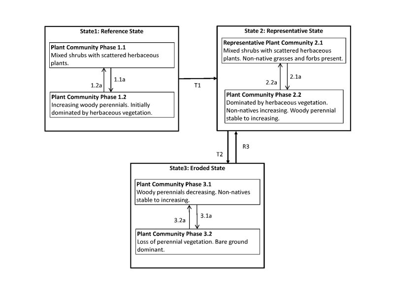
Provisional. A provisional ecological site description has undergone quality control and quality assurance review. It contains a working state and transition model and enough information to identify the ecological site.
MLRA notes
Major Land Resource Area (MLRA): 030X–Mojave Basin and Range
The Mojave Desert Major Land Resource Area (MLRA 30) is found in southern California, southern Nevada, the extreme southwest corner of Utah and northwestern Arizona within the Basin and Range Province of the Intermontane Plateaus. The Mojave Desert is a transitional area between hot deserts and cold deserts where close proximity of these desert types exert enough influence on each other to distinguish these desert types from the hot and cold deserts beyond the Mojave. Kottek et. al 2006 defines hot deserts as areas where mean annual air temperatures are above 64 F (18 C) and cold deserts as areas where mean annual air temperatures are below 64 F (18 C). Steep elevation gradients within the Mojave create islands of low elevation hot desert areas surrounded by islands of high elevation cold desert areas.
The Mojave Desert receives less than 10 inches of mean annual precipitation. Mojave Desert low elevation areas are often hyper-arid while high elevation cold deserts are often semi-arid with the majority of the Mojave being an arid climate. Hyper-arid areas receive less than 4 inches of mean annual precipitation and semi-arid areas receive more than 8 inches of precipitation (Salem 1989). The western Mojave receives very little precipitation during the summer months while the eastern Mojave experiences some summer monsoonal activity.
In summary, the Mojave is a land of extremes. Elevation gradients contribute to extremely hot and dry summers and cold moist winters where temperature highs and lows can fluctuate greatly between day and night, from day to day and from winter to summer. Precipitation falls more consistently at higher elevations while lower elevations can experience long intervals without any precipitation. Lower elevations also experience a low frequency of precipitation events so that the majority of annual precipitation may come in only a couple precipitation events during the whole year. Hot desert areas influence cold desert areas by increasing the extreme highs and shortening the length of below freezing events. Cold desert areas influence hot desert areas by increasing the extreme lows and increasing the length of below freezing events. Average precipitation and temperature values contribute little understanding to the extremes which govern wildland plant communities across the Mojave.
LRU notes
The Mojave Desert is currently divided into 4 Land Resource Units (LRUs). This ecological site is within the Arid Eastern Mojave LRU where precipitation is bi-modal, occurring during the winter months and summer months. The Arid Eastern Mojave LRU is designated by the 'XB' symbol within the ecological site ID. This LRU is found across the eastern half of California, much of the mid-elevations of Nevada, the southernmost portions of western Utah, and the mid-elevations of northwestern Arizona. This LRU is essentially equivalent to the Eastern Mojave Basins and Eastern Mojave Low Ranges and Arid Footslopes of EPA Level IV Ecoregions
Elevations range from 1650 to 4000 feet and precipitation is between 4 to 8 inches per year. This LRU is distinguished from the Arid Western Mojave (XA) by the summer precipitation, falling between July and September, which tends to support more warm season plant species. The 'XB' LRU is generally east of the Mojave River and the 117 W meridian (Hereford et. al 2004). Vegetation includes creosote bush, burrobush, Nevada jointfir, ratany, Mojave yucca, Joshua tree, cacti, big galleta grass and several other warm season grasses. At the upper portions of the LRU, plant production and diversity are greater and blackbrush is a common dominant shrub.
Ecological site concept
This site occurs on sand sheets and dunes within the basin floor landscape below 3600 feet (1100 m) but where headwaters predominantly originate above 3600 feet (1100 m). There is no water table within 30 feet (9 m) of the soil surface, indicated by the lack of western honey mesquite (Laity 2003).
Associated sites
| R030XB005NV |
Arid Active Alluvial Fans |
|---|---|
| R030XB028NV |
VALLEY WASH |
| R030XB063NV |
SANDHILL 5-7 P.Z. |
Similar sites
| R030XY046NV |
OUTWASH PLAIN Less productive site |
|---|---|
| R030XY047NV |
ALLUVIAL PLAIN Less productive site |
| R030XB121NV |
SANDY PLAIN 3-5 P.Z. ATCA2 minor species |
| R030XB004NV |
SANDY 5-7 P.Z. Less productive site; AMDU2 dominant shrub |
| R030XB032NV |
DRY FLOODPLAIN ATCA2 dominant shrub |
| R030XB037NV |
LIMY SAND 5-7 P.Z. PLRI3-ACHY codominant grasses; less productive site |
| R030XB034NV |
SANDY PLAIN 5-7 P.Z. ATPO does not occur |
| R030XB063NV |
SANDHILL 5-7 P.Z. PLRI3-ACHY codominant grasses; dune land form |
| R030XB039NV |
LIMY FAN 5-7 P.Z. Less productive site |
Table 1. Dominant plant species
| Tree |
Not specified |
|---|---|
| Shrub |
(1) Atriplex polycarpa |
| Herbaceous |
(1) Pleuraphis rigida |
Click on box and path labels to scroll to the respective text.