
Natural Resources
Conservation Service
Ecological site DX034A01X130
Overflow Green River Basin (Ov GRB)
Last updated: 5/07/2025
Accessed: 02/16/2026
General information
Provisional. A provisional ecological site description has undergone quality control and quality assurance review. It contains a working state and transition model and enough information to identify the ecological site.
MLRA notes
Major Land Resource Area (MLRA): 034A–Cool Central Desertic Basins and Plateaus
Major Land Resource Area (MLRA): 034A–Cool Central Desertic Basins and Plateaus
Major Land Resource Area (MLRA) 34A, Cool Central Desertic Basins and Plateaus, consists of approximately 21 million acres in Wyoming, Colorado and Utah, it consists of 10 Land Resource Units (LRU). These units are divisions of the MLRA based on geology, landscape, common soils, water resources and plant community potentials. The elevation ranges from approximately 5600 feet (1700 m) along the Green River in UT and CO to approximately 9500 feet (2900m) near Jeffrey City, WY. Annual precipitation ranges from 7 to 16 inches (177 to 406 mm), with the driest areas in the Green River and Great Divide Basins and the wettest areas in northern Carbon County, Southeast Fremont County and Albany County. There is a seasonal weather pattern that trends west to east, with more winter precipitation in the west and more spring/summer in the east, illustrated by diminishing amounts of Big Sagebrush in the eastern part of the MLRA.
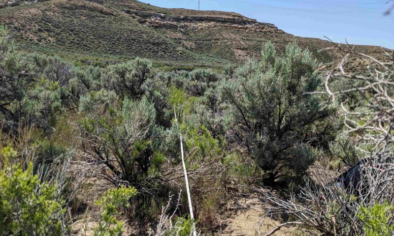
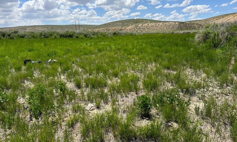
Ecological site concept
This site receives additional water from overland flow and is located in drainageways. Slopes are usually five percent or less. Soils are ustic aridic with a frigid temperature regime. Additionally, soils are typically deep to very deep (40-60 inches; 100-150 cm), are not skeletal within 20 inches (50 cm) of the soil surface, have surface textures ranging from sandy loam to clay loam (top 4 inches; 10 cm), and have less than 35% rock fragments in the upper 20 inches (50 cm). Soil chemistry does not play a significant role on this site; these soils are not saline or saline-sodic and are not violently effervescent in the surface mineral layer (within top 10 inches; 25cm). Vegetation on this site is indicative of additional moisture. Basin big sagebrush and basin wildrye are the dominant plants on this site.
Associated sites
| R034AY144WY |
Saline Upland Green River and Great Divide Basins (SU) Saline Upland Green River and Great Divide Basins - Site commonly occurs on uplands surrounding drainageways, fans, and depressional areas in which overflow sites occur. Saline Upland sites are similar to loamy sites but contain saline, sodic, or saline-sodic soils which cause salt-loving plants to dominate the site. |
|---|---|
| DX034A01X122 |
Loamy Green River Basin (Ly GRB) Loamy Green River Basin - Site commonly occurs on uplands surrounding drainageways, fans, and depressional areas in which overflow sites occur. |
Similar sites
| R034AY206WY |
Clayey Overflow Foothills and Basins West (CyO) Clayey Overflow Foothills and Basins West - Additional moisture site that occurs in drainageways, fans, and depressional areas. Clayey overflow sites are similar to overflow sites but contain greater than 32% clay in the surface texture. |
|---|---|
| DX034A01X138 |
Saline Lowland Green River Basin (SL GRB) Saline Lowland, Drained Green River Basin - Additional moisture site that occurs in drainageways, fans, and depressional areas. Saline lowland, drained sites are similar to overflow sites but contain saline, sodic, or saline sodic soils which cause salt-loving plants to dominate the site. |
Table 1. Dominant plant species
| Tree |
Not specified |
|---|---|
| Shrub |
(1) Artemisia tridentata ssp. tridentata |
| Herbaceous |
(1) Leymus cinereus |
Legacy ID
R034AB130WY
Physiographic features
This site occurs on gently sloping to moderately sloping flood plains, canyons, and small valley bottoms along intermittent streams. This site is found on all exposures and at elevations from 5800 to 6500 feet.
Table 2. Representative physiographic features
| Landforms |
(1)
Intermontane basin
> Alluvial fan
(2) Drainageway (3) Alluvial flat (4) Flood plain |
|---|---|
| Flooding frequency | Very rare to rare |
| Ponding frequency | None |
| Elevation | 5,800 – 6,500 ft |
| Slope | 1 – 5% |
| Aspect | Aspect is not a significant factor |
Table 3. Representative physiographic features (actual ranges)
| Flooding frequency | Very rare to rare |
|---|---|
| Ponding frequency | None to occasional |
| Elevation | 5,800 – 6,900 ft |
| Slope | 15% |
Climatic features
Annual precipitation ranges from 7 to 9 inches per year. Wide fluctuations may occur in yearly precipitation and result in more dry years than those with more than normal precipitation. Temperatures show a wide range between summer and winter and between daily maximums and minimums. This is predominantly due to the high elevation and dry air, which permits rapid incoming and outgoing radiation. Cold air outbreaks in winter move rapidly from northwest to southeast and account for extreme minimum temperatures. Extreme storms may occur during the winter, but most severely affect ranch operations during late winter and spring.
Daytime winds are generally stronger than nighttime and occasional strong storms may bring brief periods of high winds with gusts to more than 50 mph.
Growth of native cool season plants begins about April 15 and continues to about August 15. Some green up of cool season plants usually occurs in September depending upon fall moisture occurrences.
For detailed information visit the Natural Resources Conservation Service National Water and Climate Center at http://www.wcc.nrcs.usda.gov/cgibin/state.pl?state=wy website.
Table 4. Representative climatic features
| Frost-free period (characteristic range) | 70-87 days |
|---|---|
| Freeze-free period (characteristic range) | 107-121 days |
| Precipitation total (characteristic range) | 7-9 in |
| Frost-free period (actual range) | 66-91 days |
| Freeze-free period (actual range) | 103-125 days |
| Precipitation total (actual range) | |
| Frost-free period (average) | 79 days |
| Freeze-free period (average) | 114 days |
| Precipitation total (average) | 9 in |
Figure 1. Monthly precipitation range
Figure 2. Monthly minimum temperature range
Figure 3. Monthly maximum temperature range
Figure 4. Monthly average minimum and maximum temperature
Figure 5. Annual precipitation pattern
Figure 6. Annual average temperature pattern
Climate stations used
-
(1) ROCK SPRINGS AP [USW00024027], Rock Springs, WY
-
(2) ROCK SPRINGS FIRE DEPARTMENT [USC00487847], Rock Springs, WY
-
(3) GREEN RIVER [USC00484065], Green River, WY
Influencing water features
Surrounding uplands provide this site with additional moisture from snow melt and runoff. Because this site occurs in drainageways, depressions, and other concave forms, additional moisture accumulation influences plant communities more than other abiotic factors. This site gives dominance to plants that usually require additional moisture to establish and become abundant (ARTRT, LECI4).
While additional moisture accumulation heavily influences vegetation, this site does not receive enough additional moisture to develop shallow water tables or many redoximorphic features. Such features, if present, usually occur at 100 cm or deeper in the soil profile. However, these features may occur at shallower depths (~30 cm or deeper) if time of year, precipitation timing, and precipitation amount provide the right conditions.
Wetland description
This ecological site does not contain wetlands but may occur adjacent to wetlands.
Soil features
The soils of this site are deep to very deep (100 to 200 cm) and formed in alluvium derived from inter-bedded sedimentary rock. Surface and subsurface textures are sandy loam to clay loam. Rock fragments may be found on the soil surface or in the profile, but make up less than 15 percent of the soil volume. These soils are well-drained and have slow to moderately rapid permeability.
Landscape position is very important to this site, and it occurs in and adjacent to drainageways that receive periodic overland flow from adjacent uplands.
The soil moisture regime is ustic aridic (aridic bordering on ustic) and the soil temperature regime is frigid.
Major Soil Series correlated to this site include: Rivra, Cowestglen, Foreright, and Frandsen.
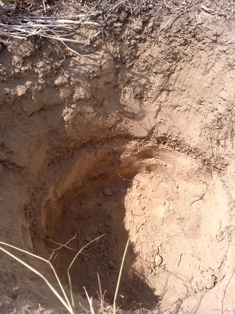
Figure 7.
Table 5. Representative soil features
| Parent material |
(1)
Alluvium
–
interbedded sedimentary rock
(2) Alluvium – metamorphic and sedimentary rock |
|---|---|
| Surface texture |
(1) Sandy clay loam (2) Sandy loam (3) Fine sandy loam |
| Family particle size |
(1) Sandy (2) Fine-loamy |
| Drainage class | Moderately well drained to well drained |
| Permeability class | Slow to moderately rapid |
| Soil depth | 40 – 80 in |
| Available water capacity (0-80in) |
0.5 – 2 in |
| Clay content (0-50in) |
11 – 30% |
Table 6. Representative soil features (actual values)
| Drainage class | Moderately well drained to well drained |
|---|---|
| Permeability class | Not specified |
| Soil depth | Not specified |
| Available water capacity (0-80in) |
0.3 – 2 in |
| Clay content (0-50in) |
5 – 30% |
Ecological dynamics
As this site deteriorates from improper grazing management, species such as rabbitbrush (Chrysothamnus) and basin big sagebrush will increase. Cool-season bunchgrasses such as basin wildrye (Leymus cinereus) and bottlebrush squirreltail (Elymus elymoides) will decrease in frequency and production.
These plant community narratives may not represent every possibility, but they are the most prevalent and repeatable plant communities. The plant composition tables shown above have been developed from the best available knowledge at the time of this revision. As more data is collected, some of these plant communities may be revised or removed, and new ones may be added. None of these plant communities should necessarily be thought of as “Desired Plant Communities”. According to the USDA NRCS National Range and Pasture Handbook, Desired Plant Communities (DPCs) will be determined by the decision-makers and will meet minimum quality criteria established by the NRCS. The main purpose for including any description of a plant community here is to capture the current knowledge and experience at the time of this revision.
The Reference state and corresponding plant communities have been determined by study of rangeland relic areas, or areas protected from excessive disturbance. Trends in plant communities going from heavily grazed areas to lightly grazed areas, seasonal use pastures, and historical accounts have also been used.
The following is a state-and-transition model diagram that illustrates the ecological dynamics of the site, including process-based states and composition-based plant community phases within each state. The diagram also contains pathways between states and plant communities that can occur on this ecological site. The ecological processes will be discussed in more detail in the plant community narratives following the diagram.
State and transition model
More interactive model formats are also available.
View Interactive Models
Click on state and transition labels to scroll to the respective text
Ecosystem states
State 1 submodel, plant communities
| 1.1A | - | Legend Continuous grazing without rest |
|---|
State 2 submodel, plant communities
State 3 submodel, plant communities
State 1
Reference

The Reference state consists of three plant communities: the Basin Big Sagebrush and Basin Wildrye community (1.1), the Basin Wildrye and Basin Big Sagebrush community (1.2), and the Basin Wildrye plant community (1.3). Each plant community differs in percent composition and foliar cover of grasses and shrubs. Forbs are a minor component. The basin wildrye plant community (1.3) is the early seral stage of this state. Basin big sagebrush later establishes leading to the mid seral stage (1.2) where basin wildrye is still dominant, but basin big sagebrush may become codominant with basin wildrye in terms of production. In the late seral stage of this state, basin big sagebrush becomes the dominant plant species (1.1). Drivers of these plant communities include: drought, fire, herbivory, and flood. To reach reference plant community (1.1), this ecological site must endure sufficient time without sagebrush killing events such as fire and flood.
Dominant plant species
-
basin big sagebrush (Artemisia tridentata ssp. tridentata), shrub
-
basin wildrye (Leymus cinereus), grass
-
milkvetch (Astragalus), other herbaceous
Community 1.1
Basin Big Sagebrush and Basin Wildrye
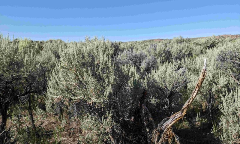
This plant community is the reference plant community. This community usually consists of basin wildrye 30 to 60 percent, rhizomatous wheatgrass 5 to 10 percent, Sandberg bluegrass 10 to 20 percent, other perennial grasses 5 to 20 percent, perennial forbs 5 to 10 percent, basin big sagebrush 10-20 percent, and 5-10 percent other woody plants. Ground cover, by ocular estimate, varies from 60 to 75 percent. The total annual production (air-dry weight) of this state is about 1200 pounds per acre, but it can range from about 800 pounds per acre in unfavorable years to about 1800 pounds per acre in above average years. This plant community is extremely stable and well adapted to the Cool Central Desertic Basins and Plateaus climatic conditions. The diversity in plant species and additional moisture allows for high drought tolerance. This is a sustainable plant community (site/soil stability, watershed function, and biologic integrity). Events such as fire, flood, or continuous season long grazing will cause transitions to different plant communities and states. Sagebrush removal or sagebrush killing events such as flood will allow basin wildrye to become the dominant species and convert this plant community to the Basin Wildrye/Basin Big Sagebrush community (1.2) or the basin wildrye community (1.3). Continuous season-long grazing will convert this plant community to the grazing resistant state in which basin big sagebrush and thickspike wheatgrass are the dominant plant species. Prolonged grazing reduces perennial bunchgrasses such as basin wildrye and increases rhizomatous grasses such as thickspike wheatgrass and Sandberg bluegrass. Basin big sagebrush remains the dominant shrub in the grazing resistant state.
Dominant plant species
-
basin big sagebrush (Artemisia tridentata ssp. tridentata), shrub
-
basin wildrye (Leymus cinereus), grass
-
milkvetch (Astragalus), other herbaceous
Figure 8. Annual production by plant type (representative values) or group (midpoint values)
Table 7. Annual production by plant type
| Plant type | Low (lb/acre) |
Representative value (lb/acre) |
High (lb/acre) |
|---|---|---|---|
| Shrub/Vine | 400 | 600 | 900 |
| Grass/Grasslike | 360 | 540 | 810 |
| Forb | 40 | 60 | 90 |
| Total | 800 | 1200 | 1800 |
Table 8. Ground cover
| Tree foliar cover | 0% |
|---|---|
| Shrub/vine/liana foliar cover | 50-75% |
| Grass/grasslike foliar cover | 15-50% |
| Forb foliar cover | 1-5% |
| Non-vascular plants | 0-1% |
| Biological crusts | 0-1% |
| Litter | 80-95% |
| Surface fragments >0.25" and <=3" | 0-1% |
| Surface fragments >3" | 0-1% |
| Bedrock | 0% |
| Water | 0% |
| Bare ground | 0-5% |
Table 9. Soil surface cover
| Tree basal cover | 0% |
|---|---|
| Shrub/vine/liana basal cover | 2-5% |
| Grass/grasslike basal cover | 5-10% |
| Forb basal cover | 1-3% |
| Non-vascular plants | 0-1% |
| Biological crusts | 0-5% |
| Litter | 0% |
| Surface fragments >0.25" and <=3" | 0-5% |
| Surface fragments >3" | 0-1% |
| Bedrock | 0% |
| Water | 0% |
| Bare ground | 70-85% |
Table 10. Canopy structure (% cover)
| Height Above Ground (ft) | Tree | Shrub/Vine | Grass/ Grasslike |
Forb |
|---|---|---|---|---|
| <0.5 | – | 2-5% | 2-20% | 0-5% |
| >0.5 <= 1 | – | 5-15% | 20-40% | – |
| >1 <= 2 | – | 10-40% | 40-60% | – |
| >2 <= 4.5 | – | 30-50% | – | – |
| >4.5 <= 13 | – | – | – | – |
| >13 <= 40 | – | – | – | – |
| >40 <= 80 | – | – | – | – |
| >80 <= 120 | – | – | – | – |
| >120 | – | – | – | – |
Figure 9. Plant community growth curve (percent production by month). WY0302, 10-14W, Extra Water Sites - LL, Ov, CyO, SL. LL. OV, CYO, SL Extra Water Sites.
| Jan | Feb | Mar | Apr | May | Jun | Jul | Aug | Sep | Oct | Nov | Dec |
|---|---|---|---|---|---|---|---|---|---|---|---|
| J | F | M | A | M | J | J | A | S | O | N | D |
| 5 | 15 | 35 | 35 | 10 |
Community 1.2
Basin Wildrye and Basin Big Sagebrush
This plant community is similar to the basin big sagebrush and basin wildrye plant community (1.1), but perennial grasses are more dominant than woody species. This plant community usually consists of basin wildrye 20 to 40 percent, rhizomatous wheatgrass 10 to 20 percent, Sandberg bluegrass 10 to 20 percent, bottlebrush squirrletail 5 to 15 percent, other perennial grasses 5 to 0 percent, perennial forbs 5 to 10 percent, basin big sagebrush 10 to 20 percent, and 5 to 10 percent other woody plants. Ground cover, by ocular estimate, varies from 60 to 75 percent. The total annual production (air-dry weight) of this state is about 1200 pounds per acre, but it can range from about 800 pounds per acre in unfavorable years to about 1800 pounds per acre in above average years. This plant community is extremely stable and well adapted to the Cool Central Desertic Basins and Plateaus climatic conditions. The diversity in plant species and additional moisture allows for high drought tolerance. This is a sustainable plant community (site/soil stability, watershed function, and biologic integrity). Further sagebrush removal or sagebrush killing events such as fire will convert this plant community to the basin wildrye community (1.3). Continuous season long grazing will convert this plant community to the grazing resistant state in which basin big sagebrush and thickspike wheatgrass are the dominant plant species. Prolonged grazing reduces perennial bunchgrasses such as basin wildrye and increases rhizomatous grasses such as thickspike wheatgrass and sandberg bluegrass. Basin big sagebrush, if present, remains the dominant shrub in the grazing resistant state.
Dominant plant species
-
basin big sagebrush (Artemisia tridentata ssp. tridentata), shrub
-
basin wildrye (Leymus cinereus), grass
-
milkvetch (Astragalus), other herbaceous
Figure 10. Annual production by plant type (representative values) or group (midpoint values)
Table 11. Annual production by plant type
| Plant type | Low (lb/acre) |
Representative value (lb/acre) |
High (lb/acre) |
|---|---|---|---|
| Grass/Grasslike | 400 | 600 | 900 |
| Shrub/Vine | 360 | 540 | 810 |
| Forb | 40 | 60 | 90 |
| Total | 800 | 1200 | 1800 |
Table 12. Ground cover
| Tree foliar cover | 0% |
|---|---|
| Shrub/vine/liana foliar cover | 0-5% |
| Grass/grasslike foliar cover | 0-5% |
| Forb foliar cover | 0-1% |
| Non-vascular plants | 0% |
| Biological crusts | 0% |
| Litter | 0% |
| Surface fragments >0.25" and <=3" | 0% |
| Surface fragments >3" | 0% |
| Bedrock | 0% |
| Water | 0% |
| Bare ground | 90-100% |
Table 13. Soil surface cover
| Tree basal cover | 0% |
|---|---|
| Shrub/vine/liana basal cover | 50-75% |
| Grass/grasslike basal cover | 15-40% |
| Forb basal cover | 0-5% |
| Non-vascular plants | 0% |
| Biological crusts | 0% |
| Litter | 80-95% |
| Surface fragments >0.25" and <=3" | 0% |
| Surface fragments >3" | 0% |
| Bedrock | 0% |
| Water | 0% |
| Bare ground | 0-5% |
Table 14. Canopy structure (% cover)
| Height Above Ground (ft) | Tree | Shrub/Vine | Grass/ Grasslike |
Forb |
|---|---|---|---|---|
| <0.5 | – | 5-10% | 2-20% | 0-5% |
| >0.5 <= 1 | – | 15-30% | 20-60% | – |
| >1 <= 2 | – | 15-40% | 20-60% | – |
| >2 <= 4.5 | – | 30-55% | – | – |
| >4.5 <= 13 | – | – | – | – |
| >13 <= 40 | – | – | – | – |
| >40 <= 80 | – | – | – | – |
| >80 <= 120 | – | – | – | – |
| >120 | – | – | – | – |
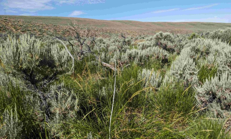
Community 1.3
Basin Wildrye
This plant community typically occurs at beginning seral stages in which basin big sagebrush has not yet established or when basin big sagebrush may be reestablishing from fire, flood, or other sagebrush killing events. This plant community may also occur in drainages where excess moisture prevents establishment of basin big sagebrush, leading to a dominance of basin wildrye and other perennial grasses. This plant community usually consists of basin wildrye 30 to 60 percent, rhizomatous wheatgrass 5 to 10 percent, Sandberg bluegrass 10 to 20 percent, other perennial grasses 5 to 20 percent, perennial forbs 5 to 10 percent, basin big sagebrush 10-20 percent, and 5 to 10 percent other woody plants. Ground cover, by ocular estimate, varies from 60 to 90 percent. The total annual production (air-dry weight) of this state is about 1200 pounds per acre, but it can range from about 800 pounds per acre in unfavorable years to about 1800 pounds per acre in above average years. This plant community is extremely stable and well adapted to the Cool Central Desertic Basins and Plateaus climatic conditions. The diversity in plant species and additional moisture allows for high drought tolerance. This is a sustainable plant community (site/soil stability, watershed function, and biologic integrity). Prolonged rest may allow basin big sagebrush to establish, leading to the Basin Wildrye/Basin Big Sagebrush community (1.2). Continuous Season-Long Grazing will convert this plant community to the grazing resistant state. Because of a lack of sagebrush in the basin wildrye phase (1.3), thickspike wheatgrass will become the dominant plant in the grazing resistant state until big sagebrush becomes dominant.
Dominant plant species
-
basin big sagebrush (Artemisia tridentata ssp. tridentata), shrub
-
basin wildrye (Leymus cinereus), grass
-
milkvetch (Astragalus), other herbaceous
Figure 11. Annual production by plant type (representative values) or group (midpoint values)
Table 15. Annual production by plant type
| Plant type | Low (lb/acre) |
Representative value (lb/acre) |
High (lb/acre) |
|---|---|---|---|
| Grass/Grasslike | 520 | 780 | 1170 |
| Shrub/Vine | 240 | 360 | 540 |
| Forb | 40 | 60 | 90 |
| Total | 800 | 1200 | 1800 |
Table 16. Ground cover
| Tree foliar cover | 0% |
|---|---|
| Shrub/vine/liana foliar cover | 5-20% |
| Grass/grasslike foliar cover | 60-80% |
| Forb foliar cover | 0-5% |
| Non-vascular plants | 0-5% |
| Biological crusts | 0% |
| Litter | 90-95% |
| Surface fragments >0.25" and <=3" | 1-5% |
| Surface fragments >3" | 1-5% |
| Bedrock | 0% |
| Water | 0% |
| Bare ground | 1-5% |
Table 17. Soil surface cover
| Tree basal cover | 0% |
|---|---|
| Shrub/vine/liana basal cover | 1-5% |
| Grass/grasslike basal cover | 1-10% |
| Forb basal cover | 1-5% |
| Non-vascular plants | 0% |
| Biological crusts | 0% |
| Litter | 0% |
| Surface fragments >0.25" and <=3" | 1-5% |
| Surface fragments >3" | 1-5% |
| Bedrock | 0% |
| Water | 0% |
| Bare ground | 90-95% |
Table 18. Canopy structure (% cover)
| Height Above Ground (ft) | Tree | Shrub/Vine | Grass/ Grasslike |
Forb |
|---|---|---|---|---|
| <0.5 | – | 2-5% | 2-20% | 0-5% |
| >0.5 <= 1 | – | 5-10% | 30-90% | – |
| >1 <= 2 | – | – | 30-90% | – |
| >2 <= 4.5 | – | – | 30-90% | – |
| >4.5 <= 13 | – | – | – | – |
| >13 <= 40 | – | – | – | – |
| >40 <= 80 | – | – | – | – |
| >80 <= 120 | – | – | – | – |
| >120 | – | – | – | – |
Pathway 1.1A
Community 1.1 to 1.2
Shrub killing event such as fire or flood
Context dependence. A transition from the basin big sage and basin wildrye community to the basin wildrye and basin big sagebrush community occurs through shrub thinning events such as fire, flood, or browsing of basin big sagebrush.
Pathway 1.1B
Community 1.1 to 1.3
Shrub thinning events such as fire or flood
Context dependence. A transition from the basin big sagebrush and basin wildrye community to the basin wildrye community occurs most commonly through flooding events, but may also occur through fire. Severe flooding events kill basin big sagebrush and allow basin wildrye to become dominant on the site. If fire occurs, the site must have an adequate seed bank of basin wildrye and must be given sufficient time without grazing to avoid invasive plants establishing on the site.
Pathway 1.2A
Community 1.2 to 1.1
Natural succession
Context dependence. A transition from the basin wildrye and basin big sagebrush community to the basin big sagebrush and basin wildrye community occurs through natural succession over time. Rest from grazing and other disturbance events allows this community to become shrub dominant.
Pathway 1.3A
Community 1.3 to 1.2
Natural succession over time
Context dependence. A transition from the basin wildrye community to the basin wildrye and basin big sagebrush community occurs through natural succession over time. Rest from grazing and other disturbance events allows this community to become shrub dominant.
State 2
Grazing Resistant

This state develops as a result of continuous grazing by wildlife and domestic livestock. Dominant grasses include thickspike wheatgrass and Sandberg bluegrass. Basin big sagebrush has increased, with annual production often exceeding 40 percent. Rubber and yellow rabbitbrush may occur but typically do not exceed 20 percent combined. The total annual production (air-dry weight) of this state is about 600 pounds per acre, but it can range from about 400 pounds per acre in unfavorable years to about 1400 pounds per acre in above average years. The state is moderately stable and somewhat vulnerable to excessive erosion. The biotic integrity of this plant community is usually intact. However, this state can be at risk depending on how far a shift has occurred in plant composition toward basin big sagebrush. The watershed is usually functioning. However, it can become at risk when canopy cover of big sagebrush and/or bare ground increases. Brush Management followed by deferment for 1 to 2 years as part of a Prescribed Grazing plan will eventually result in a plant community very similar to the reference plant community (Basin Big Sagebrush and Basin Wildrye State). Care should be taken when planning brush management to consider wildlife habitat and critical winter ranges. Wildfire followed by heavy continuous season-long grazing will result in the invaded state.
Dominant plant species
-
basin big sagebrush (Artemisia tridentata ssp. tridentata), shrub
-
yellow rabbitbrush (Chrysothamnus viscidiflorus), shrub
-
rubber rabbitbrush (Ericameria nauseosa), shrub
-
thickspike wheatgrass (Elymus lanceolatus), grass
-
Sandberg bluegrass (Poa secunda), grass
Community 2.1
Basin Big Sagebrush and Thickspike Wheatgrass
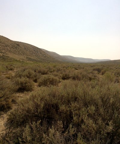
This plant community is a result of continuous grazing. Basin wildrye and other perennial bunchgrasses have decreased, and rhizomatous grasses such as thickspike wheatgrass and Sandberg bluegrass have increased. Basin big sagebrush is the dominant shrub, sometimes reaching up to 40 percent canopy cover. Yellow rabbitbrush and rubber rabbitbrush may be present, but typically never exceed 20 percent. Production is normally around 900 pounds per acre but ranges from 600 pounds per acre on below average years to 1400 pounds per acre on above average years. This plant community can return to the reference state or transition to the invaded state. To return to the reference state, brush management followed by deferment for 1 to 2 years as part of a Prescribed Grazing plan will eventually result in a plant community very similar to the basin big sagebrush and basin wildrye plant community (1.1). Care should be taken when planning brush management to consider wildlife habitat and critical winter ranges. A transition to the invaded state would be triggered by continuous heavy grazing and/or continuous heavy grazing after fire. Annuals such as cheatgrass and mustard may establish on the site, and the site may become more susceptible to erosion.
Dominant plant species
-
basin big sagebrush (Artemisia tridentata ssp. tridentata), shrub
-
rubber rabbitbrush (Ericameria nauseosa), shrub
-
yellow rabbitbrush (Chrysothamnus viscidiflorus), shrub
-
thickspike wheatgrass (Elymus lanceolatus), grass
-
Sandberg bluegrass (Poa secunda), grass
-
milkvetch (Astragalus), other herbaceous
-
fleabane (Erigeron), other herbaceous
Figure 12. Annual production by plant type (representative values) or group (midpoint values)
Table 19. Annual production by plant type
| Plant type | Low (lb/acre) |
Representative value (lb/acre) |
High (lb/acre) |
|---|---|---|---|
| Shrub/Vine | 390 | 585 | 910 |
| Grass/Grasslike | 180 | 270 | 420 |
| Forb | 30 | 45 | 70 |
| Total | 600 | 900 | 1400 |
Table 20. Ground cover
| Tree foliar cover | 0% |
|---|---|
| Shrub/vine/liana foliar cover | 10-45% |
| Grass/grasslike foliar cover | 40-45% |
| Forb foliar cover | 1-5% |
| Non-vascular plants | 1-2% |
| Biological crusts | 0% |
| Litter | 90-95% |
| Surface fragments >0.25" and <=3" | 1-5% |
| Surface fragments >3" | 0% |
| Bedrock | 0% |
| Water | 0% |
| Bare ground | 1-5% |
Table 21. Soil surface cover
| Tree basal cover | 0% |
|---|---|
| Shrub/vine/liana basal cover | 1-5% |
| Grass/grasslike basal cover | 1-5% |
| Forb basal cover | 1-2% |
| Non-vascular plants | 1-2% |
| Biological crusts | 0% |
| Litter | 0% |
| Surface fragments >0.25" and <=3" | 0% |
| Surface fragments >3" | 0% |
| Bedrock | 0% |
| Water | 0% |
| Bare ground | 90-95% |
Table 22. Canopy structure (% cover)
| Height Above Ground (ft) | Tree | Shrub/Vine | Grass/ Grasslike |
Forb |
|---|---|---|---|---|
| <0.5 | – | 1-5% | 1-5% | 1-5% |
| >0.5 <= 1 | – | 10-20% | 5-20% | – |
| >1 <= 2 | – | 20-30% | 10-20% | – |
| >2 <= 4.5 | – | 20-35% | – | – |
| >4.5 <= 13 | – | – | – | – |
| >13 <= 40 | – | – | – | – |
| >40 <= 80 | – | – | – | – |
| >80 <= 120 | – | – | – | – |
| >120 | – | – | – | – |
State 3
Invaded

This state results from excessive grazing, fire, flooding, or a combination of these events. Such events lead to erosion and soil disturbance which causes invasive plants such as cheatgrass and annual mustard to establish on the site. Basin wildrye may occur on this site, but thickspike wheatgrass and/or cheatgrass are usually dominant.
Dominant plant species
-
basin big sagebrush (Artemisia tridentata ssp. tridentata), shrub
-
yellow rabbitbrush (Chrysothamnus viscidiflorus), shrub
-
rubber rabbitbrush (Ericameria nauseosa), shrub
-
cheatgrass (Bromus tectorum), grass
-
thickspike wheatgrass (Elymus lanceolatus), grass
-
Sandberg bluegrass (Poa secunda), grass
-
basin wildrye (Leymus cinereus), grass
-
mustard (Brassica), other herbaceous
-
hairy whitetop (Cardaria pubescens), other herbaceous
-
field pennycress (Thlaspi arvense), other herbaceous
-
milkvetch (Astragalus), other herbaceous
-
desert madwort (Alyssum desertorum), other herbaceous
Community 3.1
Basin Big Sagebrush and Invasive Annuals
This plant community is a result of continuous grazing with little to no rest. This community can also result from continuous, intense grazing after a disturbance event such as fire or flood. Basin wildrye and other perennial bunchgrasses have decreased, and rhizomatous grasses such as thickspike wheatgrass have increased. Invasive annual grasses, such as cheatgrass, are common in this community and may contribute up to 50 percent of herbaceous understory production. Annual forbs such as mustard have increased and may contribute up to 30% of herbaceous understory production. If shrubs are present, basin big sagebrush is the dominant shrub. Yellow rabbitbrush and rubber rabbitbrush are also common in this community but typically do not exceed 20 percent. Production is normally around 700 pounds per acre but can range from 400 pounds per acre on below average years to 1400 pounds per acre on above average years. Bare ground may exceed 20% if the site is eroded. To return to the reference state, brush management followed by deferment for 1 to 2 years as part of a Prescribed Grazing plan will eventually result in a plant community very similar to the Basin Big Sagebrush/Basin Wildrye plant community (1.1). Prescribed fire or herbicide treatment may be necessary to remove undesirable grasses and forbs. Care should be taken when planning brush management to consider wildlife habitat and critical winter ranges.
Dominant plant species
-
basin big sagebrush (Artemisia tridentata ssp. tridentata), shrub
-
cheatgrass (Bromus tectorum), grass
-
mustard (Brassica), other herbaceous
Figure 13. Annual production by plant type (representative values) or group (midpoint values)
Table 23. Annual production by plant type
| Plant type | Low (lb/acre) |
Representative value (lb/acre) |
High (lb/acre) |
|---|---|---|---|
| Shrub/Vine | 420 | 560 | 840 |
| Grass/Grasslike | 150 | 200 | 300 |
| Forb | 30 | 40 | 60 |
| Total | 600 | 800 | 1200 |
Table 24. Ground cover
| Tree foliar cover | 0% |
|---|---|
| Shrub/vine/liana foliar cover | 0-5% |
| Grass/grasslike foliar cover | 30-60% |
| Forb foliar cover | 10-15% |
| Non-vascular plants | 0% |
| Biological crusts | 0% |
| Litter | 90-95% |
| Surface fragments >0.25" and <=3" | 0% |
| Surface fragments >3" | 0% |
| Bedrock | 0% |
| Water | 0% |
| Bare ground | 0-4% |
Table 25. Soil surface cover
| Tree basal cover | 0% |
|---|---|
| Shrub/vine/liana basal cover | 0-1% |
| Grass/grasslike basal cover | 0-5% |
| Forb basal cover | 0-2% |
| Non-vascular plants | 0% |
| Biological crusts | 0% |
| Litter | 0% |
| Surface fragments >0.25" and <=3" | 0% |
| Surface fragments >3" | 0% |
| Bedrock | 0% |
| Water | 0% |
| Bare ground | 90-95% |
Table 26. Canopy structure (% cover)
| Height Above Ground (ft) | Tree | Shrub/Vine | Grass/ Grasslike |
Forb |
|---|---|---|---|---|
| <0.5 | – | 0-5% | 0-5% | 0-5% |
| >0.5 <= 1 | – | 5-10% | 5-20% | 0-5% |
| >1 <= 2 | – | 5-15% | 10-30% | – |
| >2 <= 4.5 | – | 10-20% | – | – |
| >4.5 <= 13 | – | – | – | – |
| >13 <= 40 | – | – | – | – |
| >40 <= 80 | – | – | – | – |
| >80 <= 120 | – | – | – | – |
| >120 | – | – | – | – |
Community 3.2
Basin Wildrye and Invasive Forbs
This community is a result of sagebrush killing disturbances such as fire or flood. Basin wildrye and other perennial bunchgrasses may still dominate these sites if flooding is the only disturbance event that removes sagebrush. If continuous heavy grazing precedes or follows such disturbances, invasive annuals such as cheatgrass may establish. In either scenario, undesirable forbs such as mustard, field pennycress, and whitetop may be common and can contribute up to 35 percent of total annual production. Yellow rabbitbrush and rubber rabbitbrush are also common in this community but typically do not exceed 20 percent. Production is normally around 1200 pounds per acre but can range from 800 pounds per acre on below average years to 1400 pounds per acre on above average years. Bare ground may exceed 20 percent if the site is eroded. To return to the reference state, brush management followed by deferment for 1 to 2 years as part of a Prescribed Grazing plan will eventually result in a plant community very similar to the Basin Big Sagebrush/Basin Wildrye plant community (1.1). Prescribed fire or herbicide treatment may be necessary to remove undesirable grasses and forbs. Care should be taken when planning brush management to consider wildlife habitat and critical winter ranges.
Dominant plant species
-
basin wildrye (Leymus cinereus), grass
-
hairy whitetop (Cardaria pubescens), other herbaceous
Figure 14. Annual production by plant type (representative values) or group (midpoint values)
Table 27. Annual production by plant type
| Plant type | Low (lb/acre) |
Representative value (lb/acre) |
High (lb/acre) |
|---|---|---|---|
| Grass/Grasslike | 420 | 720 | 840 |
| Forb | 245 | 420 | 490 |
| Shrub/Vine | 35 | 60 | 70 |
| Total | 700 | 1200 | 1400 |
Transition T1A
State 1 to 2
Continuous grazing
Context dependence. A transition to the grazing resistant state depends on severity of grazing, land form, flooding, and fire. Narrow channels are usually more desirable to wildlife and livestock than surrounding upland areas, so these areas are grazed more intensely. Native bunchgrasses will be utilized quickly. Continuous grazing without rest will allow thickspike wheatgrass to increase. Additionally, basin big sagebrush in narrow channels is more susceptible to die off from flooding. Larger areas such as floodplains are still desirable to livestock and wildlife, but shrubs are less susceptible to die off from flood.
Transition T1B
State 1 to 3
Restoration pathway R1A
State 2 to 1
Resting from grazing will allow perennial bunchgrasses to reestablish on this site. If the site is to be grazed while in the grazing resistant state, a rotational grazing plan that allows for long periods of rest is recommended.
Context dependence. Restoration to reference state depends on severity of grazing, land form, flooding, and fire. In narrow channels, native shrubs and bunchgrasses may be harder to restore because these areas are grazed more intensely than nearby upland areas. Restoration of shrubs after fire and flooding events is less likely in narrow channels if these areas are continuously grazed by livestock and wildlife. In larger areas such as floodplains, restoration is more likely to succeed as long as the area is rested from grazing.
Transition T2A
State 2 to 3
Continuous grazing or continuous grazing following a fire or flood event
Context dependence. Continuous grazing without rest will cause this site to transition from the grazing resistant state to the invaded state. Severity of grazing and compaction will determine how quickly invasive annuals such as cheatgrass establish on this site. Grazing without rest after fire or flood events may cause invasive annuals to establish rapidly.
Restoration pathway R2B
State 3 to 1
Rest from grazing, herbicide treatment, prescribed fire, reseeding
Context dependence. Severity of grazing and compaction will determine how quickly shrubs and perennial bunchgrasses can reestablish. In some cases, annual grasses and undesirable forbs may completely dominate the site. Inputs such as herbicide treatment, prescribed fire, and reseeding may be necessary to return this site to the reference state. Reseeding after fire or herbicide treatment will increase the likelihood of returning to the reference state.
Restoration pathway R2A
State 3 to 2
Rest from grazing, herbicide treatment, reseeding
Context dependence. Severity of grazing and compaction will determine how quickly shrubs and perennial bunchgrasses can reestablish. In some cases, annual grasses and undesirable forbs may completely dominate the site. Inputs such as herbicide treatment or prescribed fire may be necessary to return the state to the grazing resistant state, which will eventually return to the reference state.
Additional community tables
Table 28. Community 1.1 plant community composition
| Group | Common name | Symbol | Scientific name | Annual production (lb/acre) | Foliar cover (%) | |
|---|---|---|---|---|---|---|
|
Grass/Grasslike
|
||||||
| 1 | Perennial Mi-Size Cool Season Bunchgrasses | 84–360 | ||||
| basin wildrye | LECI4 | Leymus cinereus | 60–360 | 5–30 | ||
| Indian ricegrass | ACHY | Achnatherum hymenoides | 12–120 | 1–10 | ||
| squirreltail | ELEL5 | Elymus elymoides | 0–120 | 0–10 | ||
| needle and thread | HECO26 | Hesperostipa comata | 0–120 | 0–10 | ||
| bluebunch wheatgrass | PSSP6 | Pseudoroegneria spicata | 12–120 | 1–10 | ||
| slender wheatgrass | ELTR7 | Elymus trachycaulus | 0–60 | 0–5 | ||
| Sandberg bluegrass | POSE | Poa secunda | 0–60 | 0–5 | ||
| 2 | Rhizomatous Grasses | 24–120 | ||||
| thickspike wheatgrass | ELLAL | Elymus lanceolatus ssp. lanceolatus | 12–120 | 1–10 | ||
| western wheatgrass | PASM | Pascopyrum smithii | 0–120 | 0–10 | ||
| 3 | Miscellaneous Grasses | 12–60 | ||||
| needleleaf sedge | CADU6 | Carex duriuscula | 0–60 | 0–5 | ||
| Sandberg bluegrass | POSE | Poa secunda | 12–60 | 1–5 | ||
| Grass, perennial | 2GP | Grass, perennial | 0–60 | 0–5 | ||
|
Forb
|
||||||
| 4 | Perennial Forbs | 12–48 | ||||
| aster | SYMPH4 | Symphyotrichum | 0–60 | 0–4 | ||
| lupine | LUPIN | Lupinus | 12–60 | 1–4 | ||
| hoary tansyaster | MACA2 | Machaeranthera canescens | 0–36 | 0–3 | ||
| flaxleaf plainsmustard | SCLI | Schoenocrambe linifolia | 0–36 | 0–3 | ||
| ragwort | SENEC | Senecio | 0–36 | 0–3 | ||
| scarlet globemallow | SPCO | Sphaeralcea coccinea | 0–36 | 0–3 | ||
| western yarrow | ACMIO | Achillea millefolium var. occidentalis | 12–36 | 1–3 | ||
| agoseris | AGOSE | Agoseris | 0–36 | 0–3 | ||
| milkvetch | ASTRA | Astragalus | 12–36 | 1–3 | ||
| tapertip hawksbeard | CRAC2 | Crepis acuminata | 0–36 | 0–3 | ||
| fleabane | ERIGE2 | Erigeron | 0–36 | 0–3 | ||
| buckwheat | ERIOG | Eriogonum | 0–36 | 0–3 | ||
| bluebells | MERTE | Mertensia | 0–36 | 0–3 | ||
| locoweed | OXYTR | Oxytropis | 0–36 | 0–3 | ||
| beardtongue | PENST | Penstemon | 0–36 | 0–3 | ||
| spiny phlox | PHHO | Phlox hoodii | 0–36 | 0–3 | ||
| longleaf phlox | PHLO2 | Phlox longifolia | 0–36 | 0–3 | ||
| cinquefoil | POTEN | Potentilla | 0–36 | 0–3 | ||
| sagebrush buttercup | RAGL | Ranunculus glaberrimus | 0–12 | 0–1 | ||
| ipomopsis | IPOMO2 | Ipomopsis | 0–12 | 0–1 | ||
| Rocky Mountain iris | IRMI | Iris missouriensis | 0–12 | 0–1 | ||
| povertyweed | IVAX | Iva axillaris | 0–12 | 0–1 | ||
| Lewis flax | LILE3 | Linum lewisii | 0–12 | 0–1 | ||
| cryptantha | CRYPT | Cryptantha | 0–12 | 0–1 | ||
| larkspur | DELPH | Delphinium | 0–12 | 0–1 | ||
| Indian paintbrush | CASTI2 | Castilleja | 0–12 | 0–1 | ||
| pale bastard toadflax | COUMP | Comandra umbellata ssp. pallida | 0–12 | 0–1 | ||
| onion | ALLIU | Allium | 0–12 | 0–1 | ||
| pussytoes | ANTEN | Antennaria | 0–12 | 0–1 | ||
| rockcress | ARABI2 | Arabis | 0–12 | 0–1 | ||
| hollyleaf clover | TRGY | Trifolium gymnocarpon | 0–12 | 0–1 | ||
| clover | TRIFO | Trifolium | 0–12 | 0–1 | ||
| violet | VIOLA | Viola | 0–12 | 0–1 | ||
| Forb, perennial | 2FP | Forb, perennial | 0–12 | 0–1 | ||
| desertparsley | LOMAT | Lomatium | 0–12 | 0–1 | ||
| 5 | Annual Forbs | 0–12 | ||||
| rockjasmine | ANDRO3 | Androsace | 0–12 | 0–1 | ||
| goosefoot | CHENO | Chenopodium | 0–12 | 0–1 | ||
| bushy bird's beak | CORA5 | Cordylanthus ramosus | 0–12 | 0–1 | ||
| yellow owl's-clover | ORLU2 | Orthocarpus luteus | 0–12 | 0–1 | ||
| Forb, annual | 2FA | Forb, annual | 0–12 | 0–1 | ||
|
Shrub/Vine
|
||||||
| 6 | Sagebrush | 108–480 | ||||
| basin big sagebrush | ARTRT | Artemisia tridentata ssp. tridentata | 108–480 | 9–40 | ||
| Wyoming big sagebrush | ARTRW8 | Artemisia tridentata ssp. wyomingensis | 0–240 | 0–20 | ||
| 7 | Miscellaneous Shrubs | 24–120 | ||||
| yellow rabbitbrush | CHVI8 | Chrysothamnus viscidiflorus | 24–120 | 2–10 | ||
| rubber rabbitbrush | ERNA10 | Ericameria nauseosa | 24–120 | 2–10 | ||
| currant | RIBES | Ribes | 0–60 | 0–5 | ||
| Woods' rose | ROWOW | Rosa woodsii var. woodsii | 0–60 | 0–5 | ||
| granite prickly phlox | LIPU11 | Linanthus pungens | 0–36 | 0–3 | ||
| Shrub (>.5m) | 2SHRUB | Shrub (>.5m) | 0–12 | 0–1 | ||
Table 29. Community 1.2 plant community composition
| Group | Common name | Symbol | Scientific name | Annual production (lb/acre) | Foliar cover (%) | |
|---|---|---|---|---|---|---|
|
Grass/Grasslike
|
||||||
| 1 | Perennial Mid-Size Cool season Bunchgrasses | 96–420 | ||||
| basin wildrye | LECI4 | Leymus cinereus | 120–360 | 8–35 | ||
| slender wheatgrass | ELTR7 | Elymus trachycaulus | 60–240 | 5–20 | ||
| needle and thread | HECO26 | Hesperostipa comata | 0–120 | 0–10 | ||
| Indian ricegrass | ACHY | Achnatherum hymenoides | 12–120 | 1–10 | ||
| squirreltail | ELEL5 | Elymus elymoides | 0–120 | 0–10 | ||
| Sandberg bluegrass | POSE | Poa secunda | 60–120 | 5–10 | ||
| bluebunch wheatgrass | PSSP6 | Pseudoroegneria spicata | 0–120 | 0–10 | ||
| 2 | Rhizomatous Grasses | 24–120 | ||||
| thickspike wheatgrass | ELLAL | Elymus lanceolatus ssp. lanceolatus | 0–180 | 0–15 | ||
| western wheatgrass | PASM | Pascopyrum smithii | 96–180 | 8–15 | ||
| 3 | Miscellaneous Grasses | 12–60 | ||||
| needleleaf sedge | CADU6 | Carex duriuscula | 0–60 | 0–5 | ||
| Sandberg bluegrass | POSE | Poa secunda | 12–60 | 1–5 | ||
| Grass, perennial | 2GP | Grass, perennial | 0–60 | 0–5 | ||
|
Forb
|
||||||
| 4 | Perennial Forbs | 12–48 | ||||
| lupine | LUPIN | Lupinus | 12–48 | 1–4 | ||
| aster | SYMPH4 | Symphyotrichum | 0–48 | 0–4 | ||
| hoary tansyaster | MACA2 | Machaeranthera canescens | 0–36 | 0–3 | ||
| bluebells | MERTE | Mertensia | 0–36 | 0–3 | ||
| locoweed | OXYTR | Oxytropis | 0–36 | 0–3 | ||
| beardtongue | PENST | Penstemon | 0–36 | 0–3 | ||
| spiny phlox | PHHO | Phlox hoodii | 0–36 | 0–3 | ||
| longleaf phlox | PHLO2 | Phlox longifolia | 0–36 | 0–3 | ||
| cinquefoil | POTEN | Potentilla | 0–36 | 0–3 | ||
| western yarrow | ACMIO | Achillea millefolium var. occidentalis | 12–36 | 1–3 | ||
| agoseris | AGOSE | Agoseris | 0–36 | 0–3 | ||
| milkvetch | ASTRA | Astragalus | 12–36 | 1–3 | ||
| tapertip hawksbeard | CRAC2 | Crepis acuminata | 0–36 | 0–3 | ||
| fleabane | ERIGE2 | Erigeron | 0–36 | 0–3 | ||
| buckwheat | ERIOG | Eriogonum | 0–36 | 0–3 | ||
| flaxleaf plainsmustard | SCLI | Schoenocrambe linifolia | 0–36 | 0–3 | ||
| ragwort | SENEC | Senecio | 0–36 | 0–3 | ||
| scarlet globemallow | SPCO | Sphaeralcea coccinea | 0–36 | 0–3 | ||
| ipomopsis | IPOMO2 | Ipomopsis | 0–12 | 0–1 | ||
| Rocky Mountain iris | IRMI | Iris missouriensis | 0–12 | 0–1 | ||
| povertyweed | IVAX | Iva axillaris | 0–12 | 0–1 | ||
| Lewis flax | LILE3 | Linum lewisii | 0–12 | 0–1 | ||
| desertparsley | LOMAT | Lomatium | 0–12 | 0–1 | ||
| cryptantha | CRYPT | Cryptantha | 0–12 | 0–1 | ||
| larkspur | DELPH | Delphinium | 0–12 | 0–1 | ||
| Indian paintbrush | CASTI2 | Castilleja | 0–12 | 0–1 | ||
| pale bastard toadflax | COUMP | Comandra umbellata ssp. pallida | 0–12 | 0–1 | ||
| onion | ALLIU | Allium | 0–12 | 0–1 | ||
| pussytoes | ANTEN | Antennaria | 0–12 | 0–1 | ||
| rockcress | ARABI2 | Arabis | 0–12 | 0–1 | ||
| sagebrush buttercup | RAGL | Ranunculus glaberrimus | 0–12 | 0–1 | ||
| hollyleaf clover | TRGY | Trifolium gymnocarpon | 0–12 | 0–1 | ||
| clover | TRIFO | Trifolium | 0–12 | 0–1 | ||
| violet | VIOLA | Viola | 0–12 | 0–1 | ||
| Forb, perennial | 2FP | Forb, perennial | 0–12 | 0–1 | ||
| 5 | Annual Forbs | 0–12 | ||||
| rockjasmine | ANDRO3 | Androsace | 0–12 | 0–1 | ||
| goosefoot | CHENO | Chenopodium | 0–12 | 0–1 | ||
| bushy bird's beak | CORA5 | Cordylanthus ramosus | 0–12 | 0–1 | ||
| yellow owl's-clover | ORLU2 | Orthocarpus luteus | 0–12 | 0–1 | ||
| Forb, annual | 2FA | Forb, annual | 0–12 | 0–1 | ||
|
Shrub/Vine
|
||||||
| 6 | Sagebrush | 96–420 | ||||
| basin big sagebrush | ARTRT | Artemisia tridentata ssp. tridentata | 96–420 | 8–35 | ||
| Wyoming big sagebrush | ARTRW8 | Artemisia tridentata ssp. wyomingensis | 0–120 | 0–10 | ||
| 7 | Miscellaneous Shrubs | 24–120 | ||||
| yellow rabbitbrush | CHVI8 | Chrysothamnus viscidiflorus | 12–60 | 1–5 | ||
| rubber rabbitbrush | ERNA10 | Ericameria nauseosa | 12–60 | 1–5 | ||
| currant | RIBES | Ribes | 0–60 | 0–5 | ||
| Woods' rose | ROWOW | Rosa woodsii var. woodsii | 0–60 | 0–5 | ||
| granite prickly phlox | LIPU11 | Linanthus pungens | 0–36 | 0–3 | ||
| Shrub (>.5m) | 2SHRUB | Shrub (>.5m) | 0–12 | 0–1 | ||
Table 30. Community 1.3 plant community composition
| Group | Common name | Symbol | Scientific name | Annual production (lb/acre) | Foliar cover (%) | |
|---|---|---|---|---|---|---|
|
Grass/Grasslike
|
||||||
| 1 | Perennial Mid-Size Cool Season Bunchgrasses | 108–480 | ||||
| basin wildrye | LECI4 | Leymus cinereus | 108–480 | 9–40 | ||
| slender wheatgrass | ELTR7 | Elymus trachycaulus | 60–240 | 5–20 | ||
| needle and thread | HECO26 | Hesperostipa comata | 0–120 | 0–10 | ||
| Indian ricegrass | ACHY | Achnatherum hymenoides | 12–120 | 1–10 | ||
| squirreltail | ELEL5 | Elymus elymoides | 0–120 | 0–10 | ||
| Sandberg bluegrass | POSE | Poa secunda | 60–120 | 5–10 | ||
| bluebunch wheatgrass | PSSP6 | Pseudoroegneria spicata | 0–120 | 0–10 | ||
| 2 | Rhizomatous Grasses | 36–180 | ||||
| thickspike wheatgrass | ELLAL | Elymus lanceolatus ssp. lanceolatus | 0–180 | 0–15 | ||
| western wheatgrass | PASM | Pascopyrum smithii | 96–180 | 8–15 | ||
| 3 | Miscellaneous Grasses | 24–120 | ||||
| needleleaf sedge | CADU6 | Carex duriuscula | 0–60 | 0–5 | ||
| Sandberg bluegrass | POSE | Poa secunda | 12–60 | 1–5 | ||
| Grass, perennial | 2GP | Grass, perennial | 0–60 | 0–5 | ||
|
Forb
|
||||||
| 4 | Perennial Forbs | 12–48 | ||||
| lupine | LUPIN | Lupinus | 12–60 | 1–5 | ||
| aster | SYMPH4 | Symphyotrichum | 0–60 | 0–5 | ||
| hoary tansyaster | MACA2 | Machaeranthera canescens | 0–36 | 0–3 | ||
| bluebells | MERTE | Mertensia | 0–36 | 0–3 | ||
| locoweed | OXYTR | Oxytropis | 0–36 | 0–3 | ||
| beardtongue | PENST | Penstemon | 0–36 | 0–3 | ||
| spiny phlox | PHHO | Phlox hoodii | 0–36 | 0–3 | ||
| longleaf phlox | PHLO2 | Phlox longifolia | 0–36 | 0–3 | ||
| cinquefoil | POTEN | Potentilla | 0–36 | 0–3 | ||
| western yarrow | ACMIO | Achillea millefolium var. occidentalis | 12–36 | 1–3 | ||
| agoseris | AGOSE | Agoseris | 0–36 | 0–3 | ||
| milkvetch | ASTRA | Astragalus | 12–36 | 1–3 | ||
| tapertip hawksbeard | CRAC2 | Crepis acuminata | 0–36 | 0–3 | ||
| fleabane | ERIGE2 | Erigeron | 0–36 | 0–3 | ||
| buckwheat | ERIOG | Eriogonum | 0–36 | 0–3 | ||
| flaxleaf plainsmustard | SCLI | Schoenocrambe linifolia | 0–36 | 0–3 | ||
| ragwort | SENEC | Senecio | 0–36 | 0–3 | ||
| scarlet globemallow | SPCO | Sphaeralcea coccinea | 0–36 | 0–3 | ||
| ipomopsis | IPOMO2 | Ipomopsis | 0–12 | 0–1 | ||
| Rocky Mountain iris | IRMI | Iris missouriensis | 0–12 | 0–1 | ||
| povertyweed | IVAX | Iva axillaris | 0–12 | 0–1 | ||
| Lewis flax | LILE3 | Linum lewisii | 0–12 | 0–1 | ||
| desertparsley | LOMAT | Lomatium | 0–12 | 0–1 | ||
| cryptantha | CRYPT | Cryptantha | 0–12 | 0–1 | ||
| larkspur | DELPH | Delphinium | 0–12 | 0–1 | ||
| Indian paintbrush | CASTI2 | Castilleja | 0–12 | 0–1 | ||
| pale bastard toadflax | COUMP | Comandra umbellata ssp. pallida | 0–12 | 0–1 | ||
| onion | ALLIU | Allium | 0–12 | 0–1 | ||
| pussytoes | ANTEN | Antennaria | 0–12 | 0–1 | ||
| rockcress | ARABI2 | Arabis | 0–12 | 0–1 | ||
| sagebrush buttercup | RAGL | Ranunculus glaberrimus | 0–12 | 0–1 | ||
| hollyleaf clover | TRGY | Trifolium gymnocarpon | 0–12 | 0–1 | ||
| clover | TRIFO | Trifolium | 0–12 | 0–1 | ||
| violet | VIOLA | Viola | 0–12 | 0–1 | ||
| Forb, perennial | 2FP | Forb, perennial | 0–12 | 0–1 | ||
| 5 | Annual Forbs | 0–12 | ||||
| rockjasmine | ANDRO3 | Androsace | 0–12 | 0–1 | ||
| goosefoot | CHENO | Chenopodium | 0–12 | 0–1 | ||
| bushy bird's beak | CORA5 | Cordylanthus ramosus | 0–12 | 0–1 | ||
| yellow owl's-clover | ORLU2 | Orthocarpus luteus | 0–12 | 0–1 | ||
| Forb, annual | 2FA | Forb, annual | 0–12 | 0–1 | ||
|
Shrub/Vine
|
||||||
| 6 | Sagebrush | 72–300 | ||||
| basin big sagebrush | ARTRT | Artemisia tridentata ssp. tridentata | 120–300 | 10–25 | ||
| Wyoming big sagebrush | ARTRW8 | Artemisia tridentata ssp. wyomingensis | 0–120 | 0–10 | ||
| 7 | Miscellaneous Shrubs | 12–60 | ||||
| yellow rabbitbrush | CHVI8 | Chrysothamnus viscidiflorus | 12–60 | 1–5 | ||
| rubber rabbitbrush | ERNA10 | Ericameria nauseosa | 12–60 | 1–5 | ||
| currant | RIBES | Ribes | 0–60 | 0–5 | ||
| Woods' rose | ROWOW | Rosa woodsii var. woodsii | 0–60 | 0–5 | ||
| granite prickly phlox | LIPU11 | Linanthus pungens | 0–36 | 0–3 | ||
| Shrub (>.5m) | 2SHRUB | Shrub (>.5m) | 0–12 | 0–1 | ||
Table 31. Community 2.1 plant community composition
| Group | Common name | Symbol | Scientific name | Annual production (lb/acre) | Foliar cover (%) | |
|---|---|---|---|---|---|---|
|
Grass/Grasslike
|
||||||
| 1 | Perennial Mid-Size Cool Season Bunchgrasses | 54–90 | ||||
| basin wildrye | LECI4 | Leymus cinereus | 90–270 | 10–30 | ||
| slender wheatgrass | ELTR7 | Elymus trachycaulus | 45–180 | 5–20 | ||
| needle and thread | HECO26 | Hesperostipa comata | 0–90 | 0–10 | ||
| Indian ricegrass | ACHY | Achnatherum hymenoides | 9–90 | 1–10 | ||
| squirreltail | ELEL5 | Elymus elymoides | 0–90 | 0–10 | ||
| Sandberg bluegrass | POSE | Poa secunda | 45–90 | 5–10 | ||
| bluebunch wheatgrass | PSSP6 | Pseudoroegneria spicata | 0–90 | 0–10 | ||
| 2 | Rhizomatous Grasses | 81–135 | ||||
| thickspike wheatgrass | ELLAL | Elymus lanceolatus ssp. lanceolatus | 0–135 | 0–15 | ||
| western wheatgrass | PASM | Pascopyrum smithii | 72–135 | 8–15 | ||
| 3 | Miscellaneous Grasses/Grasslikes | 21–45 | ||||
| needleleaf sedge | CADU6 | Carex duriuscula | 0–45 | 0–5 | ||
| Sandberg bluegrass | POSE | Poa secunda | 9–45 | 1–5 | ||
| Grass, perennial | 2GP | Grass, perennial | 0–45 | 0–5 | ||
|
Forb
|
||||||
| 4 | Perennial Forbs | 27–36 | ||||
| lupine | LUPIN | Lupinus | 9–45 | 1–5 | ||
| aster | SYMPH4 | Symphyotrichum | 0–45 | 0–5 | ||
| hoary tansyaster | MACA2 | Machaeranthera canescens | 0–27 | 0–3 | ||
| bluebells | MERTE | Mertensia | 0–27 | 0–3 | ||
| locoweed | OXYTR | Oxytropis | 0–27 | 0–3 | ||
| beardtongue | PENST | Penstemon | 0–27 | 0–3 | ||
| spiny phlox | PHHO | Phlox hoodii | 0–27 | 0–3 | ||
| longleaf phlox | PHLO2 | Phlox longifolia | 0–27 | 0–3 | ||
| cinquefoil | POTEN | Potentilla | 0–27 | 0–3 | ||
| western yarrow | ACMIO | Achillea millefolium var. occidentalis | 9–27 | 1–3 | ||
| agoseris | AGOSE | Agoseris | 0–27 | 0–3 | ||
| milkvetch | ASTRA | Astragalus | 9–27 | 1–3 | ||
| tapertip hawksbeard | CRAC2 | Crepis acuminata | 0–27 | 0–3 | ||
| fleabane | ERIGE2 | Erigeron | 0–27 | 0–3 | ||
| buckwheat | ERIOG | Eriogonum | 0–27 | 0–3 | ||
| flaxleaf plainsmustard | SCLI | Schoenocrambe linifolia | 0–27 | 0–3 | ||
| ragwort | SENEC | Senecio | 0–27 | 0–3 | ||
| scarlet globemallow | SPCO | Sphaeralcea coccinea | 0–27 | 0–3 | ||
| ipomopsis | IPOMO2 | Ipomopsis | 0–9 | 0–1 | ||
| Rocky Mountain iris | IRMI | Iris missouriensis | 0–9 | 0–1 | ||
| povertyweed | IVAX | Iva axillaris | 0–9 | 0–1 | ||
| Lewis flax | LILE3 | Linum lewisii | 0–9 | 0–1 | ||
| desertparsley | LOMAT | Lomatium | 0–9 | 0–1 | ||
| cryptantha | CRYPT | Cryptantha | 0–9 | 0–1 | ||
| larkspur | DELPH | Delphinium | 0–9 | 0–1 | ||
| Indian paintbrush | CASTI2 | Castilleja | 0–9 | 0–1 | ||
| pale bastard toadflax | COUMP | Comandra umbellata ssp. pallida | 0–9 | 0–1 | ||
| onion | ALLIU | Allium | 0–9 | 0–1 | ||
| pussytoes | ANTEN | Antennaria | 0–9 | 0–1 | ||
| rockcress | ARABI2 | Arabis | 0–9 | 0–1 | ||
| sagebrush buttercup | RAGL | Ranunculus glaberrimus | 0–9 | 0–1 | ||
| hollyleaf clover | TRGY | Trifolium gymnocarpon | 0–9 | 0–1 | ||
| clover | TRIFO | Trifolium | 0–9 | 0–1 | ||
| violet | VIOLA | Viola | 0–9 | 0–1 | ||
| Forb, perennial | 2FP | Forb, perennial | 0–9 | 0–1 | ||
| 5 | Annual Forbs | 0–9 | ||||
| rockjasmine | ANDRO3 | Androsace | 0–9 | 0–1 | ||
| goosefoot | CHENO | Chenopodium | 0–9 | 0–1 | ||
| bushy bird's beak | CORA5 | Cordylanthus ramosus | 0–9 | 0–1 | ||
| yellow owl's-clover | ORLU2 | Orthocarpus luteus | 0–9 | 0–1 | ||
| Forb, annual | 2FA | Forb, annual | 0–9 | 0–1 | ||
|
Shrub/Vine
|
||||||
| 6 | Sagebrush | 342–540 | ||||
| basin big sagebrush | ARTRT | Artemisia tridentata ssp. tridentata | 90–180 | 10–20 | ||
| Wyoming big sagebrush | ARTRW8 | Artemisia tridentata ssp. wyomingensis | 0–90 | 0–10 | ||
| 7 | Miscellaneous Shrubs | 27–45 | ||||
| yellow rabbitbrush | CHVI8 | Chrysothamnus viscidiflorus | 9–45 | 1–5 | ||
| rubber rabbitbrush | ERNA10 | Ericameria nauseosa | 9–45 | 1–5 | ||
| currant | RIBES | Ribes | 0–45 | 0–5 | ||
| Woods' rose | ROWOW | Rosa woodsii var. woodsii | 0–45 | 0–5 | ||
| granite prickly phlox | LIPU11 | Linanthus pungens | 0–27 | 0–3 | ||
| Shrub (>.5m) | 2SHRUB | Shrub (>.5m) | 0–9 | 0–1 | ||
Table 32. Community 3.1 plant community composition
| Group | Common name | Symbol | Scientific name | Annual production (lb/acre) | Foliar cover (%) | |
|---|---|---|---|---|---|---|
|
Grass/Grasslike
|
||||||
| 1 | Perennial Mid-Size Cool Season Bunchgrasses | 32–40 | ||||
| basin wildrye | LECI4 | Leymus cinereus | 80–240 | 10–30 | ||
| slender wheatgrass | ELTR7 | Elymus trachycaulus | 40–160 | 5–20 | ||
| needle and thread | HECO26 | Hesperostipa comata | 0–80 | 0–10 | ||
| Indian ricegrass | ACHY | Achnatherum hymenoides | 8–80 | 1–10 | ||
| squirreltail | ELEL5 | Elymus elymoides | 0–80 | 0–10 | ||
| Sandberg bluegrass | POSE | Poa secunda | 40–80 | 5–10 | ||
| bluebunch wheatgrass | PSSP6 | Pseudoroegneria spicata | 0–80 | 0–10 | ||
| 2 | Rhizomatous Grasses | 32–40 | ||||
| thickspike wheatgrass | ELLAL | Elymus lanceolatus ssp. lanceolatus | 0–120 | 0–15 | ||
| western wheatgrass | PASM | Pascopyrum smithii | 64–120 | 8–15 | ||
| 3 | Miscellaneous Grasses | 36–40 | ||||
| needleleaf sedge | CADU6 | Carex duriuscula | 0–40 | 0–5 | ||
| Sandberg bluegrass | POSE | Poa secunda | 8–40 | 1–5 | ||
| Grass, perennial | 2GP | Grass, perennial | 0–40 | 0–5 | ||
| 4 | Annual Grasses | 72–80 | ||||
| cheatgrass | BRTE | Bromus tectorum | 8–80 | 1–10 | ||
|
Forb
|
||||||
| 5 | Perennial Forbs | 24–32 | ||||
| aster | SYMPH4 | Symphyotrichum | 0–40 | 0–5 | ||
| western yarrow | ACMIO | Achillea millefolium var. occidentalis | 8–24 | 1–3 | ||
| agoseris | AGOSE | Agoseris | 0–24 | 0–3 | ||
| milkvetch | ASTRA | Astragalus | 8–24 | 1–3 | ||
| fleabane | ERIGE2 | Erigeron | 0–24 | 0–3 | ||
| hoary tansyaster | MACA2 | Machaeranthera canescens | 0–24 | 0–3 | ||
| ragwort | SENEC | Senecio | 0–24 | 0–3 | ||
| povertyweed | IVAX | Iva axillaris | 0–8 | 0–1 | ||
| pale bastard toadflax | COUMP | Comandra umbellata ssp. pallida | 0–8 | 0–1 | ||
| cryptantha | CRYPT | Cryptantha | 0–8 | 0–1 | ||
| onion | ALLIU | Allium | 0–8 | 0–1 | ||
| rockcress | ARABI2 | Arabis | 0–8 | 0–1 | ||
| Forb, perennial | 2FP | Forb, perennial | 0–8 | 0–1 | ||
| 6 | Annual Forbs | 0–8 | ||||
| rockjasmine | ANDRO3 | Androsace | 0–8 | 0–1 | ||
| goosefoot | CHENO | Chenopodium | 0–8 | 0–1 | ||
| bushy bird's beak | CORA5 | Cordylanthus ramosus | 0–8 | 0–1 | ||
| yellow owl's-clover | ORLU2 | Orthocarpus luteus | 0–8 | 0–1 | ||
| Forb, annual | 2FA | Forb, annual | 0–8 | 0–1 | ||
| Forb, annual | 2FA | Forb, annual | 0–8 | 0–1 | ||
|
Shrub/Vine
|
||||||
| 7 | Sagebrush | 432–520 | ||||
| basin big sagebrush | ARTRT | Artemisia tridentata ssp. tridentata | 80–520 | 10–65 | ||
| Wyoming big sagebrush | ARTRW8 | Artemisia tridentata ssp. wyomingensis | 0–80 | 0–10 | ||
| 8 | Miscellaneous Shrubs | 32–40 | ||||
| yellow rabbitbrush | CHVI8 | Chrysothamnus viscidiflorus | 8–40 | 1–5 | ||
| rubber rabbitbrush | ERNA10 | Ericameria nauseosa | 8–40 | 1–5 | ||
| currant | RIBES | Ribes | 0–40 | 0–5 | ||
| Woods' rose | ROWOW | Rosa woodsii var. woodsii | 0–40 | 0–5 | ||
| granite prickly phlox | LIPU11 | Linanthus pungens | 0–24 | 0–3 | ||
| Shrub (>.5m) | 2SHRUB | Shrub (>.5m) | 0–8 | 0–1 | ||
Table 33. Community 3.2 plant community composition
| Group | Common name | Symbol | Scientific name | Annual production (lb/acre) | Foliar cover (%) | |
|---|---|---|---|---|---|---|
|
Grass/Grasslike
|
||||||
| 1 | Perennial Mid-Size Cool Season Bunchgrasses | 96–540 | ||||
| basin wildrye | LECI4 | Leymus cinereus | 120–360 | 10–30 | ||
| slender wheatgrass | ELTR7 | Elymus trachycaulus | 60–240 | 5–20 | ||
| needle and thread | HECO26 | Hesperostipa comata | 0–120 | 0–10 | ||
| Indian ricegrass | ACHY | Achnatherum hymenoides | 12–120 | 1–10 | ||
| squirreltail | ELEL5 | Elymus elymoides | 0–120 | 0–10 | ||
| Sandberg bluegrass | POSE | Poa secunda | 60–120 | 5–10 | ||
| bluebunch wheatgrass | PSSP6 | Pseudoroegneria spicata | 0–120 | 0–10 | ||
| 2 | Rhizomatous Grasses | 32–40 | ||||
| thickspike wheatgrass | ELLAL | Elymus lanceolatus ssp. lanceolatus | 0–180 | 0–15 | ||
| western wheatgrass | PASM | Pascopyrum smithii | 96–180 | 8–15 | ||
| 3 | Miscellaneous Grasses | 32–40 | ||||
| needleleaf sedge | CADU6 | Carex duriuscula | 0–60 | 0–5 | ||
| Sandberg bluegrass | POSE | Poa secunda | 12–60 | 1–5 | ||
| Grass, perennial | 2GP | Grass, perennial | 0–60 | 0–5 | ||
| 4 | Annual Grasses | 72–80 | ||||
| cheatgrass | BRTE | Bromus tectorum | 12–120 | 1–10 | ||
|
Forb
|
||||||
| 5 | Perennial Forbs | 60–360 | ||||
| whitetop | CARDA2 | Cardaria | 60–360 | 5–30 | ||
| aster | SYMPH4 | Symphyotrichum | 0–60 | 0–5 | ||
| hoary tansyaster | MACA2 | Machaeranthera canescens | 0–36 | 0–3 | ||
| ragwort | SENEC | Senecio | 0–36 | 0–3 | ||
| fleabane | ERIGE2 | Erigeron | 0–36 | 0–3 | ||
| western yarrow | ACMIO | Achillea millefolium var. occidentalis | 12–36 | 1–3 | ||
| agoseris | AGOSE | Agoseris | 0–36 | 0–3 | ||
| milkvetch | ASTRA | Astragalus | 12–36 | 1–3 | ||
| onion | ALLIU | Allium | 0–12 | 0–1 | ||
| rockcress | ARABI2 | Arabis | 0–12 | 0–1 | ||
| povertyweed | IVAX | Iva axillaris | 0–12 | 0–1 | ||
| pale bastard toadflax | COUMP | Comandra umbellata ssp. pallida | 0–12 | 0–1 | ||
| cryptantha | CRYPT | Cryptantha | 0–12 | 0–1 | ||
| Forb, perennial | 2FP | Forb, perennial | 0–12 | 0–1 | ||
| 6 | Annual Forbs | 12–60 | ||||
| field pennycress | THAR5 | Thlaspi arvense | 12–60 | 1–5 | ||
| herb sophia | DESO2 | Descurainia sophia | 0–24 | 0–2 | ||
| yellow owl's-clover | ORLU2 | Orthocarpus luteus | 0–12 | 0–1 | ||
| rockjasmine | ANDRO3 | Androsace | 0–12 | 0–1 | ||
| goosefoot | CHENO | Chenopodium | 0–12 | 0–1 | ||
| bushy bird's beak | CORA5 | Cordylanthus ramosus | 0–12 | 0–1 | ||
| Forb, annual | 2FA | Forb, annual | 0–12 | 0–1 | ||
| Forb, annual | 2FA | Forb, annual | 0–8 | 0–1 | ||
|
Shrub/Vine
|
||||||
| 7 | Sagebrush | 12–48 | ||||
| basin big sagebrush | ARTRT | Artemisia tridentata ssp. tridentata | 120–240 | 10–20 | ||
| Wyoming big sagebrush | ARTRW8 | Artemisia tridentata ssp. wyomingensis | 0–120 | 0–10 | ||
| 8 | Miscellaneous Shrubs | 0–12 | ||||
| yellow rabbitbrush | CHVI8 | Chrysothamnus viscidiflorus | 12–60 | 1–5 | ||
| rubber rabbitbrush | ERNA10 | Ericameria nauseosa | 12–60 | 1–5 | ||
| currant | RIBES | Ribes | 0–60 | 0–5 | ||
| Woods' rose | ROWOW | Rosa woodsii var. woodsii | 0–60 | 0–5 | ||
| granite prickly phlox | LIPU11 | Linanthus pungens | 0–36 | 0–3 | ||
| Shrub (>.5m) | 2SHRUB | Shrub (>.5m) | 0–12 | 0–1 | ||
Interpretations
Animal community
Animal Community – Wildlife Interpretations
Basin big sagebrush and basin wildrye plant communities contain a high degree of plant species and structural diversity, additional moisture, and woody plants in this community which favor a large variety of wildlife. Basin big sage provides suitable thermal and escape cover for mule deer, elk, and antelope. This plant community provides brood rearing/foraging areas as well as important wintering habitat for sage grouse. This community provides habitat for a wide array of small mammals such as jackrabbits, cottontail rabbits, mice, and voles so diverse prey populations are available for badgers, fox, coyotes, and raptors such as red-tail and Swainson’s hawks. Birds such as sage sparrow, Brewer’s sparrow, and the sage thrasher will utilize this community for nesting and foraging.
Basin Big Sagebrush and Basin Wildrye plant community: This plant community may be useful for the same wildlife that would use the reference state. However, the plant community composition is less diverse, and thus, less apt to meet the seasonal needs of these animals.
Silver Sagebrush/Rabbitbrush Plant Community: The plant community composition is much less diverse, and thus, less apt to meet the seasonal needs of many wildlife dependent on big sagebrush.
Animal Community – Grazing Interpretations
The following table lists suggested stocking rates for cattle under continuous season-long grazing under normal growing conditions. These are conservative estimates that should be used only as guidelines in the initial stages of the conservation planning process. Often, the current plant composition does not entirely match any particular plant community (as described in this ecological site description). Because of this, a field visit is recommended, in all cases, to document plant composition and production. More precise carrying capacity estimates should eventually be calculated using this information along with animal preference data, particularly when grazers other than cattle are involved. Under more intensive grazing management, improved harvest efficiencies can result in an increased carrying capacity.
Plant Community Production (lb./ac) and Carrying Capacity* (AUM/ac)
Basin Big Sagebrush/Basin Wildrye: 1200-2200 lb./ac and .6 AUM/ac
Basin Big Sagebrush/Wheatgrass: 400-1400 lb./ac and .3 AUM/ac
Basin Wildrye/Annual Forb: 200-1000 lb./ac and .15 AUM/ac
* - Continuous, season-long grazing by cattle under average growing conditions.
Grazing by domestic livestock is one of the major income-producing industries in the area. Rangeland in this area may provide yearlong forage for cattle, sheep, or horses. During the dormant period, the forage for livestock use needs to be supplemented with protein because the quality does not meet minimum livestock requirements.
Hydrological functions
Water is the principal factor limiting forage production on this site. This site is dominated by soils in hydrologic group B and C. Infiltration ranges from moderate to rapid. Runoff potential for this site varies from moderate to high depending on soil hydrologic group and ground cover. In many cases, areas with greater than 75% ground cover have the greatest potential for high infiltration and lower runoff. Areas where ground cover is less than 50% have the greatest potential to have reduced infiltration and higher runoff (refer to Part 630, NRCS National Engineering Handbook for detailed hydrology information).
Rills and gullies should not typically be present. Water flow patterns should be barely distinguishable if at all present. Pedestals are only slightly present in association with bunchgrasses. Litter typically falls in place, and signs of movement are not common. Chemical and physical crusts are rare to non-existent. Cryptogrammic crusts are present, but only cover 1-2% of the soil surface.
Recreational uses
This site provides hunting opportunities for upland game species. The wide variety of plants which bloom from spring until fall have esthetic values that appeal to visitors.
Wood products
No appreciable wood products are present on the site.
Other products
None noted.
Supporting information
Inventory data references
Ten low intensity plots collected by soil scientists in from 2012 to 2022 entered into NASIS.
Individual observations are listed in EDIT and are viewable behind login.
Type locality
| Location 1: Sweetwater County, WY | |
|---|---|
| General legal description | Site located on federal land managed by Bureau of Land Management |
References
-
Bestelmeyer, B., J.R. Brown, K.M. Havstad, B. Alexander, G. Chavez, and J.E. Herrick. 2003. Development and Use of State and Transition Models for Rangelands. Jornal of Range Management 56:114–126.
-
Bestelmeyer, B., J.R. Brown, J.E. Herrick, D.A. Trujillo, and K.M. Havstad. 2004. Land Management in the American Southwest: a state-and-transition approach to ecosystem complexity. Environmental Management 34:38–51.
-
Bestelmeyer, B.T., K. Moseley, P.L. Shaver, H. Sanchez, D.D. Briske, and M.E. Fernandez-Gimenez. 2010. Practical guidance for developing state-and-transition models. Rangelands 32:23–30.
-
Bowker, K.A. 2000. Jonah Field: A Shallow Sweetspot in the Basin-Centered Gas Accumulation of the Northern Green River Basin, Wyoming..
-
Chambers, J.C., J.L. Beck, T.J. Christiansen, K.J. Clause, J.B. Dinkins, K.E. Doherty, K.A. Griffin, D.W. Havlina, K.F. Henke, L.L. Kurth, J.D. Maestas, M. Manning, K.E. Mayer, B.A. Mealor, C. McCarthy, M.A. Perea, and D.A. Pyke. 2016. Using resilience and resistance concepts to manage threats to sagebrush ecosystems, Gunnison sage-grouse, and Greater sage-grouse in their eastern range: A strategic multi-scale approach.. Gen. Tech. Rep. RMRS-GTR-356.. U.S. Department of Agriculture, Forest Service, Rocky Mountain Research Station, Fort Collins, CO. 1–143.
-
Innes, R.J. 2019. Fire regimes of Wyoming big sagebrush and basin big sagebrush communities.. Fire Effects Information System. U.S. Department of Agriculture, Forest Service, Rocky Mountain Research Station, Missoula Fire Sciences Laboratory.
-
USDA, N. 2018 (Date accessed). The PLANTS Database. http://plants.usda.gov.
Other references
Ecological Site-Scale Hydrologic Response in a Semiarid Rangeland Watershed. Austin M. Carey, Ginger B. Paige. Rangeland Ecology & Management 69:481-490, 2016
Contributors
Joseph Galanti
Approval
Kirt Walstad, 5/07/2025
Rangeland health reference sheet
Interpreting Indicators of Rangeland Health is a qualitative assessment protocol used to determine ecosystem condition based on benchmark characteristics described in the Reference Sheet. A suite of 17 (or more) indicators are typically considered in an assessment. The ecological site(s) representative of an assessment location must be known prior to applying the protocol and must be verified based on soils and climate. Current plant community cannot be used to identify the ecological site.
| Author(s)/participant(s) | Joseph Galanti |
|---|---|
| Contact for lead author | joseph.galanti@usda.gov |
| Date | 01/08/2025 |
| Approved by | Kirt Walstad |
| Approval date | |
| Composition (Indicators 10 and 12) based on | Annual Production |
Indicators
-
Number and extent of rills:
-
Presence of water flow patterns:
-
Number and height of erosional pedestals or terracettes:
-
Bare ground from Ecological Site Description or other studies (rock, litter, lichen, moss, plant canopy are not bare ground):
-
Number of gullies and erosion associated with gullies:
-
Extent of wind scoured, blowouts and/or depositional areas:
-
Amount of litter movement (describe size and distance expected to travel):
-
Soil surface (top few mm) resistance to erosion (stability values are averages - most sites will show a range of values):
-
Soil surface structure and SOM content (include type of structure and A-horizon color and thickness):
-
Effect of community phase composition (relative proportion of different functional groups) and spatial distribution on infiltration and runoff:
-
Presence and thickness of compaction layer (usually none; describe soil profile features which may be mistaken for compaction on this site):
-
Functional/Structural Groups (list in order of descending dominance by above-ground annual-production or live foliar cover using symbols: >>, >, = to indicate much greater than, greater than, and equal to):
Dominant:
Sub-dominant:
Other:
Additional:
-
Amount of plant mortality and decadence (include which functional groups are expected to show mortality or decadence):
-
Average percent litter cover (%) and depth ( in):
-
Expected annual annual-production (this is TOTAL above-ground annual-production, not just forage annual-production):
-
Potential invasive (including noxious) species (native and non-native). List species which BOTH characterize degraded states and have the potential to become a dominant or co-dominant species on the ecological site if their future establishment and growth is not actively controlled by management interventions. Species that become dominant for only one to several years (e.g., short-term response to drought or wildfire) are not invasive plants. Note that unlike other indicators, we are describing what is NOT expected in the reference state for the ecological site:
-
Perennial plant reproductive capability:
Print Options
Sections
Font
Other
The Ecosystem Dynamics Interpretive Tool is an information system framework developed by the USDA-ARS Jornada Experimental Range, USDA Natural Resources Conservation Service, and New Mexico State University.
Click on box and path labels to scroll to the respective text.
Ecosystem states
State 1 submodel, plant communities
| 1.1A | - | Legend Continuous grazing without rest |
|---|