Natural Resources
Conservation Service
Ecological site R043AX963MT
Alpine Shallow Meadow yellow avalanche-lily-Scouler’s St. Johnswort-alpine leafybract aster-Sitka valerian- heartleaf arnica/Hitchcock’s smooth woodrush
Last updated: 4/10/2025
Accessed: 04/14/2025
General information
Provisional. A provisional ecological site description has undergone quality control and quality assurance review. It contains a working state and transition model and enough information to identify the ecological site.
MLRA notes
Major Land Resource Area (MLRA): 043A–Northern Rocky Mountains
This MLRA is located in Montana (43 percent), Idaho (34 percent), and Washington (23 percent). It makes up about 31,435 square miles (81,460 square kilometers). It has no large cities or towns. It has many national forests, including the Okanogan, Colville, Kootenai, Lolo, Flathead, Coeur d’Alene, St. Joe, Clearwater, and Kaniksu National Forests.
This MLRA is in the Northern Rocky Mountains Province of the Rocky Mountain System. It is characterized by rugged, glaciated mountains; thrust- and block-faulted mountains; and hills and valleys. Steep-gradient rivers have cut deep canyons. Natural and manmade lakes are common.
The major Hydrologic Unit Areas (identified by four-digit numbers) that make up this MLRA are: Kootenai-Pend Oreille-Spokane (1701), 67 percent; Upper Columbia (1702), 18 percent; and Lower Snake (1706), 15 percent. Numerous rivers originate in or flow through this area, including, the Sanpoil, Columbia, Pend Oreille, Kootenai, St. Joe, Thompson, and Flathead Rivers.
This area is underlain primarily by stacked slabs of layered sedimentary or metasedimentary bedrock. The bedrock formations range from Precambrian to Cretaceous in age. The rocks consist of shale, sandstone, siltstone, limestone, argillite, quartzite, gneiss, schist, dolomite, basalt, and granite. The formations have been faulted and stacked into a series of imbricate slabs by regional tectonic activity. Pleistocene glaciers carved a rugged landscape that includes sculpted hills and narrow valleys filled with till and outwash. Continental glaciation over road the landscape in the northern half of the MLRA while glaciation in the southern half was confined to montane settings.
The average annual precipitation is 25 to 60 inches (635 to 1,525 millimeters) in most of this area, but it is as much as 113 inches (2,870 millimeters) in the mountains and is 10 to 15 inches (255 to 380 millimeters) in the western part of the area. Summers are dry. Most of the precipitation during fall, winter, and spring is snow. The average annual temperature is 32 to 51 degrees F (0 to 11 degrees C) in most of the area, decreasing with elevation. In most of the area, the freeze-free period averages 140 days and ranges from 65 to 215 days. It is longest in the low valleys of Washington, and it decreases in length with elevation. Freezing temperatures occur every month of the year on high mountains, and some peaks have a continuous cover of snow and ice.
The dominant soil orders in this MLRA are Andisols, Inceptisols, and Alfisols. Many of the soils are influenced by Mount Mazama ash deposits. The soils in the area have a frigid or cryic soil temperature regime; have an ustic, xeric, or udic soil moisture regime; and dominantly have mixed mineralogy. They are shallow to very deep, are very poorly drained to well drained, and have most of the soil texture classes. The soils at the lower elevations include Udivitrands, Vitrixerands and Haplustalfs. The soils at the higher elevations include Dystrocryepts, Eutrocryepts, Vitricryands , and Haplocryalfs. Cryorthents, Cryepts, and areas of rock outcrop are on ridges and peaks above timberline
This area is in the northern part of the Northern Rocky Mountains. Grand fir, Douglas-fir, western red cedar, western hemlock, western larch, lodgepole pine, subalpine fir, ponderosa pine, whitebark pine, and western white pine are the dominant overstory species, depending on precipitation, temperature, elevation, and landform aspect. The understory vegetation varies, also depending on climatic and landform factors. Some of the major wildlife species in this area are whitetailed deer, mule deer, elk, moose, black bear, grizzly bear, coyote, fox, and grouse. Fish, mostly in the trout and salmon families, are abundant in streams, rivers, and lakes.
More than one-half of this area is federally owned and administered by the U.S. Department of Agriculture, Forest Service. Much of the privately-owned land is controlled by large commercial timber companies. The forested areas are used for wildlife habitat, recreation, watershed, livestock grazing, and timber production. Meadows provide summer grazing for livestock and big game animals. Less than 3 percent of the area is cropland.
LRU notes
This ecological site resides in MLRA 43A in the Livingston-Lewis-Apgar Mountains which includes the bulk of Glacier National Park (GNP) and the lower western valley portions along the Flathead River. The landscape is mountains and landforms include glaciated mountains with associated features such as U-shaped valleys, mountain slopes, alpine ridges, cirques, valley floors and moraines. Glaciation of this area was in the form of alpine, icecaps and valley outlet glaciers. It also includes associated alluvium and outwash features. This area includes low valleys to tall mountains with elevation ranging 989-2,762 m (3,250-9,050 ft.). The climate is cold and wet with mean annual air temperature of 3 degrees Celsius (37 degrees F)., mean frost free days of 65 days and mean annual precipitation of 1,295 mm (51 in.) and relative effective annual precipitation is 169 cm (66 in.). The soil temperature regime is cryic and the soil moisture regime is udic. The geology of this area is dominated by metasedimentary rocks of the Belt Supergroup (Grinnell argillite and Siyeh limestone) with minor Tertiary sediments. Soils are generally weakly developed on mountain slopes within U-shaped valleys. Parent materials are commonly of colluvium, till, and residuum from metasedimentary rocks. Limestone bedrock within this part of the Belt Supergroup is not highly calcareous and due to high precipitation received in this area most carbonates at mid and upper elevations have been leached from the soil profiles. Bedrock depth varies greatly with location, landform and slope position. Volcanic ash is often found in the soil surface with various degrees of mixing. Thicker volcanic ash can be found on more stable positions on mid and upper elevation slopes that are protected from wind erosion. Volcanic ash is not typically found in low elevation areas on stream and outwash terraces associated with streams and rivers. There are numerous large lakes including St. Mary, Bowman, Kintla, Lake Sherburne, Logging, Upper Waterton and numerous creeks (
Classification relationships
NPS Plant Community Name:
This ecological site relates to the NatureServe classification Luzula glabrata var. hitchcockii-erythronium grandiflorum Herbaceous Vegetation (CEGL005873).
Ecological site concept
Ecological Site Concept
The 43A Alpine Shallow Meadow ecological site is found on a wide range of high elevation sites that share in common cold winter temperatures, heavy snow loading, and a short growing season. These are large patch size meadows. These sites are on backslopes, with generally slopes below 35 percent, but can be found on steep backslope positions, and on all aspects. It is typically found at the base of talus slopes and on large, broad areas on colluvial aprons. The vegetation community that defines this ecological site includes perennial snow-loving forbs and grasses, sedges, and rushes. This site is very diverse with early, mid, and late season blooming forbs. The defining species include yellow avalanche lily (Erythronium grandiflorum), Scoulers St. Johnswort (Hypericum scouleri), alpine leafybract aster (Symphyotrichum foliaceum), Hitchcocks smooth woodrush (Luzula glabrata var. hitchcockii), shortstalk sedge (Carex podocarpa). There is a constant presence of subalpine fir (Abies lasciocarpa), but it provides very low cover. Species at this site are not wetland obligates, rather some may have moderate affinity to wetlands while others to uplands. The 43A Alpine Shallow Meadow ecological site is found on soils that are shallow to moderately deep, well drained, have a high amount of rock fragments, and form from till or colluvium over residuum soil parent materials. These soils very rarely have a surface organic layer, and it is typically less than 5 cm deep if it occurs. Half of the soils are loamy-skeletal, but there is a significant occurrence of ash. Taxonomically these soils are classified as either dark, humus-rich Mollisols, Inceptisols with lesser soil development or Andisols with the presence of volcanic ash, dependent upon how protected the sites are to disturbance and erosional factors. Soils in more protected sites tend to be Haplocryolls or Haplocryands, while more exposed areas may have less soil development and will be Haplocryepts. There are two minor inclusions that are included within the larger context of this ecological site. These are convex knobs that are dominated by yellow mountain heath and shallow ledges or bedrock outcrops that are dominated by shortstalk sedge.
Associated sites
| F043AX954MT |
Upper Subalpine Cold Coniferous subalpine fir (Engelmann spruce) /thinleaf huckleberry-rusty menziesia/ Hitchcock’s smooth woodrush-beargrass/yellow avalanche lily. The 43A Upper Subalpine Cold Coniferous (ABLA/LUGLH) ecological site is found along the continental divide in cold, and moist to moderately dry, high elevations in the upper subalpine. It is primarily on cirque platform and headwall landforms, on backslope and shoulder positions at elevations ranging 1,700 to 2,600 meters (5,575-8,530 feet) with moderate to steep slopes ranging 10% to 80%.The 43A Upper Subalpine Cold Coniferous (ABLA/LUGLH) has soils associated with this ecological site that are moderately deep, well drained and derived from glacial till or colluvium over residuum weathered from metasedimentary rock. Moderately deep depth class indicates that these soils are greater than 50 cm (20 inches) deep, but less than 100 cm (40 inches). These soils classify in the Inceptisols soil order and in the Typic Haplocryepts taxonomic subgroup. The 43A Upper Subalpine Cold Coniferous (ABLA/LUGLH) ecological site has a reference vegetation community of subalpine fir (and minor Engelmann spruce) with an understory of thinleaf huckleberry, rusty menziesia, Hitchcock’s smooth woodrush-beargrass and yellow avalanche lily. |
|---|---|
| R043AX972MT |
Alpine Shallow Cirque Floors Arctic willow – pink mountainheath-alpine laurel /smallwing sedge -shortstalk sedge (Salix arctica-Phyllodoce empetriformis/Kalmia polifolia/Carex microptera-Carex podocarpa) The 43A Alpine Shallow Cirque Floors is found on very low to moderate slopes on cirque floors or platforms on northern and eastern aspects at high elevations ranging from 1,800-2,400 m. (5,900-7,875 feet). These sites are low sloping and are generally associated with a small drainageway that allows for occasional flooding of brief duration of the months April through June, and overland flow of water and very brief seasonal ponding.The 43A Alpine Shallow Cirque Floors has soils are very poorly drained and are shallow in depth. They occur on cirque floors and cirque platforms and are generally formed in colluvial parent material. The 43A Alpine Shallow Cirque Floors ecological site has a reference vegetation community of Arctic willow (Salix arctica) with minor amounts of pink mountainheath (Phyllodoce empetriformis), alpine laurel (Kalmia polifolia)) with an understory of smallwing sedge (Carex microptera), shortstalk sedge (Carex podocarpa), Drummond’s rush (Juncus drummondii), fringed grass of Parnassus (Parnassia fimbriata) and elephanthead lousewort (Pedicularis groenlandica). |
| R043AX962MT |
Alpine Unstable Talus rocky ledge penstemon (Penstemon ellipticus) The 43A Alpine Unstable Talus ecological site resides on extensive talus slopes on very steep to steep slopes with a surface dominated by large rock fragments or talus. The landforms are cirque headwalls, colluvial aprons and glacial valley walls. The 43A alpine unstable talus ecological site has soils that are deep, well to somewhat excessively drained and have abundant rock fragments throughout. These soils are generally classified in the Entisols or Inceptisols soil orders, indicating that they have virtually no soil development because they are on active positions of the landscape or have only weakly developed soil diagnostic characteristics. The 43A alpine unstable talus ecological site has a reference vegetation community of Rocky ledge penstemon (Penstemon ellipticus), buttecandle (Cryptantha celosioides), silverleaf phacelia (Phacelia hastata) and alpine leafybract aster (Symphyotrichum foliaceum). |
Table 1. Dominant plant species
| Tree |
Not specified |
|---|---|
| Shrub |
Not specified |
| Herbaceous |
(1) Erythronium grandiflorum |
Physiographic features
The 43A Alpine Shallow Meadow ecological site is found on a wide range of high elevation sites that share in common cold winter temperatures, heavy snow loading, and a short growing season. These are large patch size meadows. These sites are on backslopes, with generally slopes below 35 percent, but can be found on steep backslope positions, and on all aspects. It is found at the base of talus slopes and on large, broad areas on colluvial aprons. It also is found in linear areas between ribbons of high elevation forests (whitebark pine-subalpine fir) found on cirque platforms and headwalls, roche moutonées, or scoured bedrock knobs and hills, and saddles.
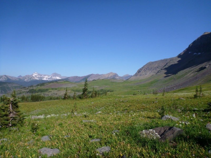
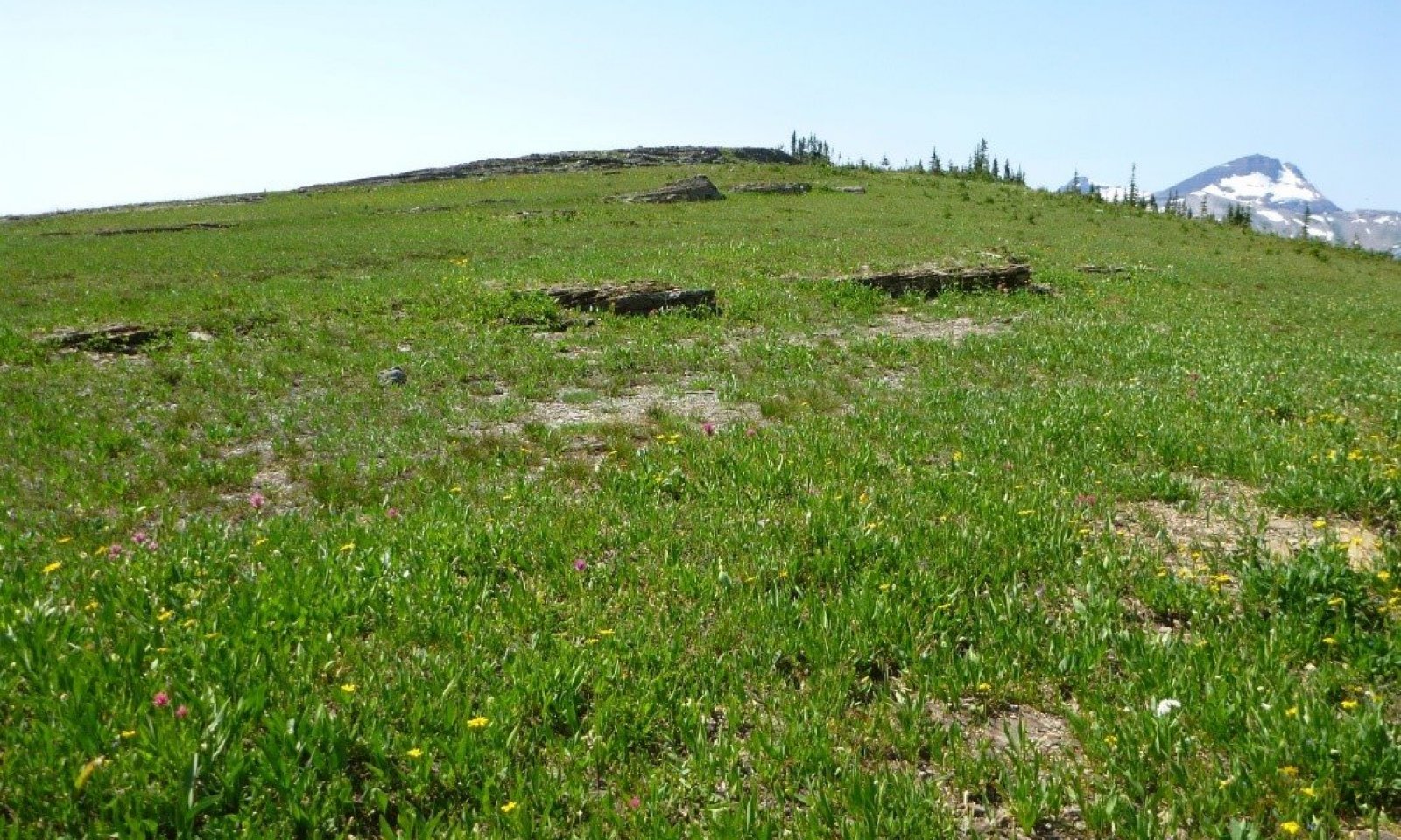
Figure 1. Landscape view of the 43A Alpine Shallow Meadow interfacing with the 43A Alpine Unstable Talus ecological site.
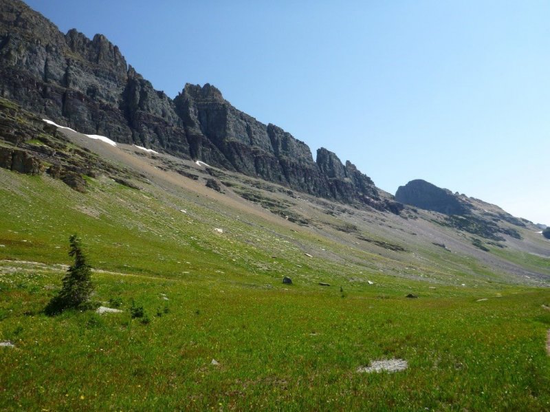
Figure 2. Landscape view of this ecological site on the broad colluvial apron with its associated ecological site 43A Alpine Unstable Talus on steep slopes.
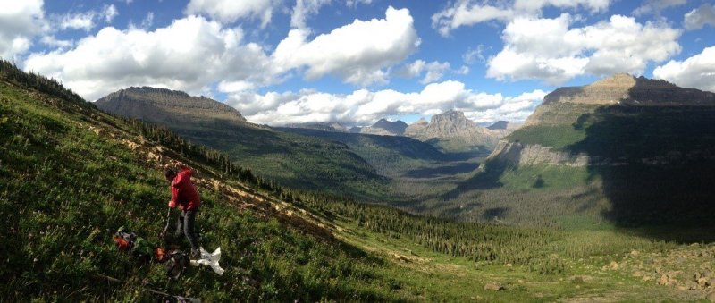
Figure 3. Landscape view of the ecological site.
Table 2. Representative physiographic features
| Landforms |
(1)
Mountains
> Roche moutonnee
(2) Mountains > Cirque headwall (3) Mountains > Colluvial apron |
|---|---|
| Elevation | 610 – 792 m |
| Slope | 10 – 40% |
| Aspect | W, NW, N, NE, E, SE, S, SW |
Table 3. Representative physiographic features (actual ranges)
| Elevation | 610 – 792 m |
|---|---|
| Slope | 10 – 60% |
Climatic features
The 43A Alpine Shallow Meadow ecological site is found in the cryic soil temperature regime and the udic soil moisture regime. Cryic soils have average annual temperature less than 8 degrees C, with less than 5 degrees C difference from winter to summer. Udic soil moisture regime denotes that the rooting zone is usually moist throughout the winter and the majority of summer.
INFORMATION REPRESENTATIVE OF THIS SITE:
Mean Average Precipitation: 97-249 cm 38-98 inches
Mean Average Annual Temperature: -2 to 4 Celsius 28-39 degrees F.
Frost free days: 30-50
INFORMATION IN TABLES BELOW ARE FROM CLIMATE STATIONS LOCATED IN VALLEYS AND MAY NOT BE REPRESENTATIVE OF THIS SITE.
Table 4. Representative climatic features
| Frost-free period (characteristic range) | 57-86 days |
|---|---|
| Freeze-free period (characteristic range) | 111-131 days |
| Precipitation total (characteristic range) | 533-737 mm |
| Frost-free period (actual range) | 17-87 days |
| Freeze-free period (actual range) | 75-132 days |
| Precipitation total (actual range) | 508-813 mm |
| Frost-free period (average) | 66 days |
| Freeze-free period (average) | 116 days |
| Precipitation total (average) | 635 mm |
Figure 4. Monthly precipitation range
Figure 5. Monthly minimum temperature range
Figure 6. Monthly maximum temperature range
Figure 7. Monthly average minimum and maximum temperature
Figure 8. Annual precipitation pattern
Figure 9. Annual average temperature pattern
Climate stations used
-
(1) POLEBRIDGE [USC00246615], Essex, MT
-
(2) WEST GLACIER [USC00248809], Kalispell, MT
-
(3) HUNGRY HORSE DAM [USC00244328], Kalispell, MT
-
(4) WHITEFISH [USC00248902], Whitefish, MT
-
(5) LINDBERGH LAKE [USC00245043], Seeley Lake, MT
-
(6) POLEBRIDGE 1 N [USC00246618], Essex, MT
Influencing water features
Soil features
The 43A Alpine Shallow Meadow ecological site is found on soils that are shallow to moderately deep, well drained, have a high amount of rock fragments, and form from till or colluvium over residuum soil parent materials. These soils very rarely have a surface organic layer, and it is typically less than 5 cm deep if it occurs. Half of the soils are loamy-skeletal, but there is a significant occurrence of ash. Taxonomically these soils are classified as either dark, humus-rich Mollisols, Inceptisols with lesser soil development or Andisols with the presence of volcanic ash, dependent upon how protected the sites are to disturbance and erosional factors. Soils in more protected sites tend to be Haplocryolls or Haplocryands, while more exposed areas may have less soil development and will be Haplocryepts. Diagnostic features include a mollic or ochric epipedon, cambic horizon, and andic soil properties (Soil Survey Staff, 2015). For more information on soil taxonomy, please follow this link:
http://http://www.nrcs.usda.gov/wps/portal/nrcs/detail/soils/survey/class/?cid=nrcs142p2_053580
SOIL SERIES: COEROCK, CUBERANT, KATKITOS, SCALPLOCK
SOIL TAXONOMY:
Coerock= Medial-skeletal, amorphic Lithic Vitricryands
Cuberant= Loamy-skeletal, mixed, superactive Typic Haplocryepts
Katikitos= Medial, amorphic Lithic Haplocryands
Scalplock= Loamy-skeletal, mixed, superactive Lithic Haplocryolls
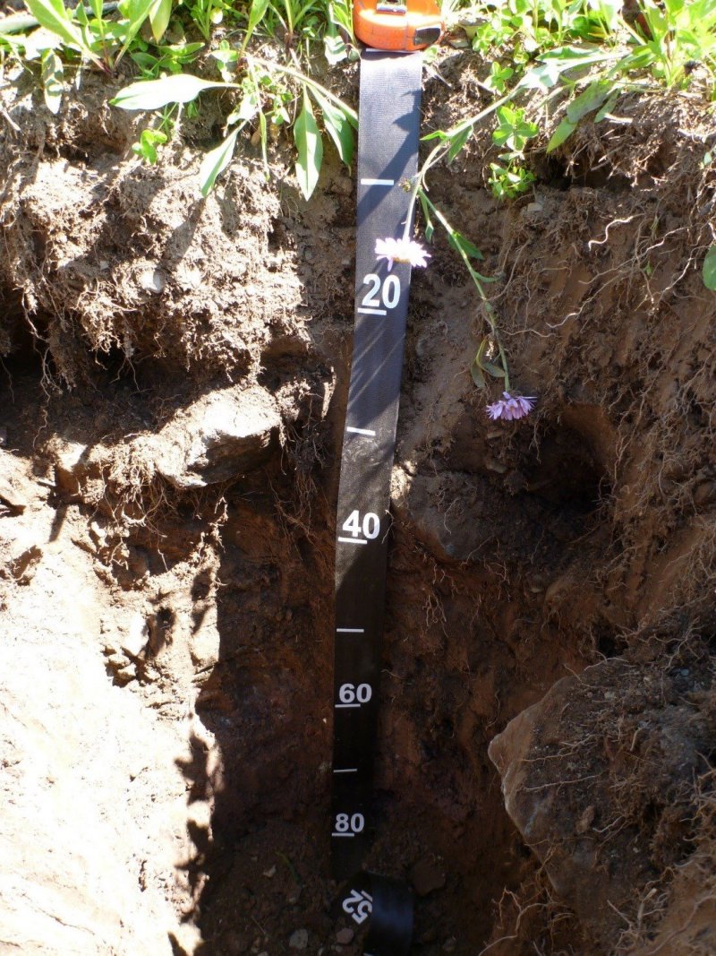
Figure 10. Close up view of a soil pit showing the high volume of fragments and skeletal nature of the soil.
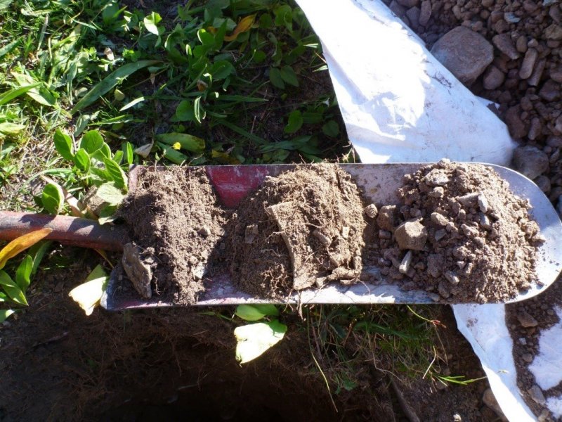
Figure 11. Soil horizons from pit at this ecological site, note the number of fine roots.
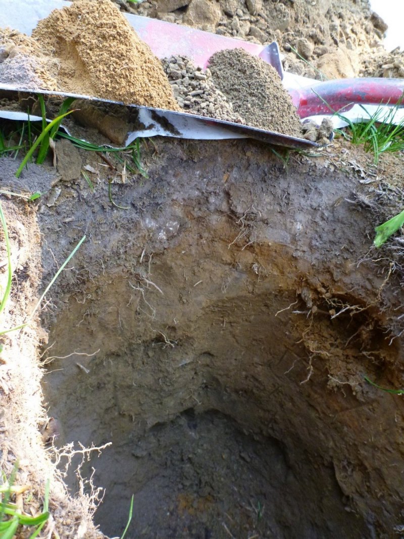
Figure 12. Close up view of various soil colors within the profile found at this ecological site.
Table 5. Representative soil features
| Parent material |
(1)
Colluvium
–
metasedimentary rock
(2) Residuum – metasedimentary rock (3) Volcanic ash – metasedimentary rock |
|---|---|
| Surface texture |
(1) Very gravelly loam (2) Very channery loam (3) Ashy loam |
| Family particle size |
(1) Loamy-skeletal |
| Drainage class | Well drained |
| Permeability class | Moderate |
| Soil depth | 25 – 102 cm |
| Surface fragment cover <=3" | 5 – 30% |
| Surface fragment cover >3" | 5 – 20% |
| Available water capacity (2.5-8.1cm) |
Not specified |
| Soil reaction (1:1 water) (11.4-18.3cm) |
Not specified |
Table 6. Representative soil features (actual values)
| Drainage class | Not specified |
|---|---|
| Permeability class | Not specified |
| Soil depth | 25 – 102 cm |
| Surface fragment cover <=3" | Not specified |
| Surface fragment cover >3" | Not specified |
| Available water capacity (2.5-8.1cm) |
Not specified |
| Soil reaction (1:1 water) (11.4-18.3cm) |
Not specified |
Ecological dynamics
Plant Community Dynamics
The vegetation community that defines the 43A Alpine Shallow Meadow ecological site includes perennial snow-loving forbs and grasses, sedges, and rushes. This site is very diverse with early, mid, and late season blooming forbs. The defining species include yellow avalanche lily (Erythronium grandiflorum), Scouler’s St. Johnswort (Hypericum scouleri), alpine leafybract aster (Symphyotrichum foliaceum), Hitchcock’s smooth woodrush (Luzula glabrata var. hitchcockii), shortstalk sedge (Carex podocarpa). There is a constant presence of subalpine fir (Abies lasciocarpa), but it provides very low cover. Species at this site are not wetland obligates, rather some may have moderate affinity to wetlands while others to uplands.
This community goes through a phenological sequence of blooming. The earliest species to bloom, directly after snowmelt, is lanceleaf springbeauty (Claytonia lanceolata). This is followed by yellow avalanche-lily and then Hitchcock’s smooth woodrush. Shortstalk and smallwing sedges bloom in May through August. Next to bloom in June and July are pacific anemone (Anemone multifida), broadleaf arnica (Arnica latifolia), and nineleaf biscuitroot. Flowering from June through August are other Arnica species, autumn dwarf gentian (Gentianella amarella), Hitchcock’s smooth woodrush, and western meadow-rue (Thalictrum occidentale). In July and August, numerous species bloom including Aster species, splitleaf Indian paintbrush (Castelleja rhexifolia), western showy aster (Eurybia conspicua), Scouler’s St. Johnswort (Hypericum scouleri subsp. scouleri), arrowleaf ragwort (Senecio triangularis), Sitka valerian (Valeriana sitchensis), American alpine speedwell (Veronica wormskjoldii), and mountain deathcamas (Zigadenus elegans). Near summer’s end, the rushes bloom in July through September, including Drummond’s rush (Juncus drummondii) and Mertens’ rush (Juncus mertensianus). By mid-August, the subalpine fleabane blooms. Lastly, alpine leafybract aster (Symphyotrichum foliaceum) and sticky purple geranium (Geranium viscosissimum) bloom in August through September.
The 43A Alpine Shallow Meadow ecological site is found primarily on toeslope and backslope positions of cirque walls, colluvial aprons or saddles with smooth or linear slope shapes. It also is found in linear areas between ribbons of high elevation forests (whitebark pine-subalpine fir) found on cirque floors and walls, roche moutonées, and saddles. These landforms have the typical vegetation community of this ecological site. It can also be found on bedrock controlled areas which are gently rolling, undulating landforms with variable depths to bedrock resulting in more varied overall vegetation community with minor vegetation inclusions. On convex knobs within this undulating landform, there is a distinct increase in the presence of yellow mountainheath. These are interspersed between linear to concave positions with the vegetation community typical of this ecological site. There are only two instances in which obligate wetland species occur at this site, and these are patches of the dwarf shrub alpine laurel (Kalmia microphylla) and undergreen willow (Salix commutata) within concave positions that are often ponded, of this ecological site. On areas close to bedrock outcrops or ledges, with very shallow to shallow soils, there is predominance of shortstalk sedge (Carex podocarpa).
This community is considered intermediate in its snow-holding capacity: it holds less snow than the ecological site 43A Nivation Hollow (dominated by turf forming sedges), which can sit directly next to glaciers and perennial snowfields at the highest elevations, and has a concave position that holds snow longer than surrounding areas. The alpine shallow meadow ecological site, in contrast, is found primarily on toeslope positions of colluvial slopes or in gently rolling, slightly wind-protected positions on undulating landforms. Snow accumulates on these landforms and the growing season is only 3.5 to 4 months long. There are few species that tolerate these site conditions. Thus, there is an affinity of species between the Nivation Hollows and the Alpine Shallow Meadow vegetation communities, in that similar sedge species occur in both ecological sites, though in far different proportions. The Nivation Hollow community is dominated by sedges.
The 43A Alpine Shallow Meadow ecological site is generally moist and, for the most part, does not burn frequently. The closest fire regime to this ecological site is that of the Northern Rocky Mountain Alpine and Subalpine Meadows and Grasslands community (Landfire, 2005), which has a fire interval of 350 years for replacement fire interval and 750 years for mixed fire interval, the average for all fires is 239 years (Agee, 1993). The National Park Service (NPS) regards the fire return interval for the Logan Pass area (this area is dominated by the alpine shallow meadow ecological site) to be approximately 200 years, maybe up to 300 or more (personal communication, McClellan, NPS Fire Effects, 2016). Hitchcock’s smooth woodrush is a co-dominant at this ecological site. It is a short, rhizomatous perennial rush specie that regenerates into extensive colonies. It also reproduces via seed, which is dispersed by the splash cup method using raindrops, wind, or the vibrations of passing animals. It is considered an indicator of cold environments, found mainly where deep snow lies late at high elevations. Following fire, it resprouts from surviving rhizomes after the fire consumes all aboveground parts. Hitchcock’s smooth woodrush has been shown to increase in biomass following fire. Another of the main species found on this site is yellow avalanche-lily, a perennial forb with a deep corm. After fire, it can resprout from the corm. Yellow avalanche-lily is pollinated by bumblebees and other species of bees, and needs 100 days of cold stratification before germination. A fire would destroy that year’s seeds, preventing new plant establishment during the first post-fire year.
The 43A Alpine Shallow Meadow ecological site sustains disturbance from wildlife, particularly grizzly bears digging for the yellow avalanche-lily corms. Following digging disturbance, the seral progression proceeds from mineral soil colonized by moss species, then Hitchcock’s smooth woodrush, which forms a dense stand. Eventually, this is invaded by other forb species. Other animals that disturb this ecological site by digging for food or burrowing include gophers, marmots, voles, and other rodents. Yellow avalanche lily also is important forage for ground squirrels, sheep, cattle, horses, elk, and mule deer (Ellison, 1954).
Hansen et al. in 1995 found that certain species included in this site were generally good or fair forage for sheep, cattle, and horses including alpine leafybract aster, heartleaf arnica, fireweed, sticky geranium, and arrowleaf ragwort. These species were generally low in energy and protein value in the fall and winter. These species were general good to fair food value for elk, mule and whitetail deer, and antelope. Alpine leafybract aster and arrowleaf ragwort were deemed good to fair food value for upland, waterfowl, small mammals, and small non-game birds, while fireweed and sticky geranium were fair to poor in those categories.
The 43A Alpine Shallow Meadow ecological site is impacted by human trampling from visitors. In a long-term study monitoring visitor impact on Logan Pass in Glacier National Park, Hartley (2000) found that it took up to 30 years to recover after trampling treatments to pre-treatment ratios of vegetation, litter, and bare ground. Vegetation took 19-25 years to recover after trampling 15 times per week, and 25-30 years when trampled 50 times per week. In studies on trampling by Landals and Scotter (1973, 1974), it was found that the community type Sitka valerian subalpine forb meadow responded to repetitive trampling by a dramatic drop in canopy cover of 75 percent within 100 passes. It was categorized as being somewhat susceptible to both light and heavy trampling. This meant that it took 26-100 passes to reduce cover to 50 percent of the original condition. The relative cover after 800 passes was 8-15 percent, which was categorized as neither susceptible nor resistant. Alpine leafybract aster (Symphyotrichum foliaceum) was considered neither resistant nor sensitive to trampling, whereas heartleaf arnica and showy aster were considered sensitive species.
A yellow mountainheath subalpine meadow also was found to respond dramatically to trampling with a similar decrease in canopy cover. It was categorized as being somewhat susceptible to light trampling. This meant that it took 26-100 passes to reduce cover to 50 percent of the original condition. It was categorized as very susceptible to heavy trampling, meaning that relative vegetation cover after 800 passes was 0-3 percent.
Climate change may have an effect on this community. Altered temperature and precipitation regimes as well as changes in the extent of glaciers and snowpack will have a more pronounced effect on plants in the alpine. Plants in this ecological site are adapted to living in the harsh alpine environment with a short growing season. Changes to snowpack will particularly effect plants that are the earliest flowering species. Erythronium grandiflorum is one the earliest flowering species and was shown to flower earlier by 4.14 days per decade over a 30 year period (Lambert, 2010). Snowmelt was shown to be arriving earlier, which caused earlier flowering. Numerous animals rely on Erythronium grandiflorum and the shift in earlier flowering may have cascading effects. Queen bumblebees, broad tailed hummingbirds, elk, deer and grizzly beer rely on it for green vegetation food directly after snowmelt in early spring.
STATE 1.0:
Community Phase 1.1:
Yellow avalanche-lily (Erythronium grandiflorum)-Scouler’s St. Johnswort (Hypericum scouleri)-alpine leafybract aster (Symphyotrichum foliaceum)-Sitka valerian (Valeriana sitchensis)-heartleaf arnica (Arnica cordifolia)/Hitchcock’s smooth woodrush (Luzula glabrata var. hitchcockii)-shortstalk sedge (Carex podocarpa).
This community phase has high foliar cover and the ground cover is predominantly litter and duff, though can have moderate cover of soil and trace amounts of bedrock, stones, cobbles, gravel and moss. The vegetation structure is a fairly uniform two layers, one 10-20 inches tall and another layer below 10 inches tall of diverse forb and grass species. The tallest common specie, Alpine timothy (Phleum alpinum) can be 40 inches tall. Only thinleaf huckleberry which occurs sporadically and green false hellebore (Veratrum viride) can reach heights of 30 inches tall. The 10-20 inches tall layer can include sticky purple geranium (Geranium viscosissimum), yellow avalanche lily (Erythronium grandiflorum), broadleaf arnica (Arnica latifolia), aster, bromus and senecio species. The lower layer below 10 inches can include Payson’s sedge (Carex paysonis), Drummond’s rush (Juncus drummondii), shortstalk sedge (Carex podocarpa), Hitchcock’s smooth woodrush (Luzula glabrata var. hitchcockii), Scouler’s St. Johnswort (Hypericum scouleri), creeping sibbaldia (Sibbaldia procumbens) and other forbs and grasses.
Community Phase 1.2: This community has reduced foliar cover than community phase 1.1 due to grazing or trampling. There is an increase in bare ground cover and compaction of the soil. This community is at additional risk to crossing a threshold to State 2.0.
Community Phase 1.3: This community has sustained bear digging in which the soil has been churned over, aerating the soil and exposing buried plant propagules. The recovery time from this small scale disturbance is short. The seral progression is colonizing moss species, then Hitchcock’s smooth woodrush and perennial forb species re-establish on the site.
Community Phase Pathway 1.1a
This represents extensive animal trails or trampling by humans which lead to an increase in bare ground, compaction of soil, lowering of total foliar cover, change in species composition, and/or a lowering of total productivity of the site. Drought conditions would exacerbate the disturbance and lengthen recovery time. The disturbance may be extensive.
Community Phase Pathway 1.1.b.
This represents disturbance by bear digging and rodent burrowing, which lead to a churning of soil, aeration and exposure of buried plant propagules. This disturbance is small in area generally and the vegetation recovers quickly.
Community Phase Pathway 1.2.A.
This represents a resumption of production and composition by species to the reference state by a decrease in grazing or trampling by humans.
Community Phase Pathway 1.3A
This represents time without extensive bear digging in which the seral progression of colonizing moss species, Hitchcock’s smooth woodrush and perennial forb species re-establish on the site.
STATE 2.0:
Community Phase 2.1: This community has sustained a dramatic reduction in foliar cover, species production or even a change in species composition from the Reference Community (1.1) due to intense grazing or trampling.
Table 1. Canopy cover data for species present in community phase 1.1 for this ecological site including count of frequency and canopy cover values (average, minimum and maximum).
Minor vegetation community within this ecological site, found on convex positions:
Pink mountainheath (Phyllodoce empetriformis)-yellow mountainheath (Phyllodoce glanduliflora)/creeping sibbaldia (Sibbaldia procumbens)-subalpine fleabane (Erigeron peregrinus)/Payson’s sedge (Carex paysonis)-Hitchcock’s smooth woodrush (Luzula glabrata var. hitchcockii)-Mertens’ rush (Juncus mertensianus)-Parry’s rush (Juncus parryi). Foliar cover at this community phase is high and the ground cover is predominantly litter and duff with fairly high moss cover and trace cover of cobbles, gravel, lichen and soil. The vegetation structure is of one layer that is short, less than 10 inches tall and can include pink mountainheath (Phyllodoce empetriformis)-yellow mountainheath (Phyllodoce glanduliflora)/creeping sibbaldia (Sibbaldia procumbens)-subalpine fleabane (Erigeron peregrinus)/Payson’s sedge (Carex paysonis)-hitchcock’s smooth woodrush(Luzula glabrata var. hitchcockii)-Mertens’ rush (Juncus mertensianus)-Parry’s rush (Juncus parryi).
State and transition model
More interactive model formats are also available.
View Interactive Models
Click on state and transition labels to scroll to the respective text
Ecosystem states
State 1 submodel, plant communities
State 2 submodel, plant communities
State 1
Reference
The vegetation community that defines the reference phase of43A Alpine Shallow Meadow ecological site includes perennial snow-loving forbs and grasses, sedges, and rushes. This site is very diverse with early, mid, and late season blooming forbs. The defining species include yellow avalanche lily (Erythronium grandiflorum), Scouler’s St. Johnswort (Hypericum scouleri), alpine leafybract aster (Symphyotrichum foliaceum), Hitchcock’s smooth woodrush (Luzula glabrata var. hitchcockii), shortstalk sedge (Carex podocarpa). There is a constant presence of subalpine fir (Abies lasciocarpa), but it provides very low cover. Species at this site are not wetland obligates, rather some may have moderate affinity to wetlands while others to uplands. Bear and rodent digging will churn up the soil and have an increase in bare ground which will lead to phase 1.3. In the event of sustained human trampling, the reference phase vegetation community will have an increase in bare ground, some soil compaction and trace to low cover of weedy species, which indicate phase 1.2. This community goes through a phenological sequence of blooming. The earliest species to bloom, directly after snowmelt, is lanceleaf springbeauty (Claytonia lanceolata). This is followed by yellow avalanche-lily and then Hitchcock’s smooth woodrush. Shortstalk and smallwing sedges bloom in May through August. Next to bloom in June and July are pacific anemone (Anemone multifida), broadleaf arnica (Arnica latifolia), and nineleaf biscuitroot. Flowering from June through August are other Arnica species, autumn dwarf gentian (Gentianella amarella), Hitchcock’s smooth woodrush, and western meadow-rue (Thalictrum occidentale). In July and August, numerous species bloom including Aster species, splitleaf Indian paintbrush (Castelleja rhexifolia), western showy aster (Eurybia conspicua), Scouler’s St. Johnswort (Hypericum scouleri subsp. scouleri), arrowleaf ragwort (Senecio triangularis), Sitka valerian (Valeriana sitchensis), American alpine speedwell (Veronica wormskjoldii), and mountain deathcamas (Zigadenus elegans). Near summer’s end, the rushes bloom in July through September, including Drummond’s rush (Juncus drummondii) and Mertens’ rush (Juncus mertensianus). By mid-August, the subalpine fleabane blooms. Lastly, alpine leafybract aster (Symphyotrichum foliaceum) and sticky purple geranium (Geranium viscosissimum) bloom in August through September. This community is considered intermediate in its snow-holding capacity: it holds less snow than the ecological site 43A Nivation Hollow (dominated by turf forming sedges), which can sit directly next to glaciers and perennial snowfields at the highest elevations, and has a concave position that holds snow longer than surrounding areas. The alpine shallow meadow ecological site, in contrast, is found primarily on toeslope positions of colluvial slopes or in gently rolling, slightly wind-protected positions on undulating landforms. Snow accumulates on these landforms and the growing season is only 3.5 to 4 months long. There are few species that tolerate these site conditions. Thus, there is an affinity of species between the Nivation Hollows and the Alpine Shallow Meadow vegetation communities, in that similar sedge species occur in both ecological sites, though in far different proportions. The Nivation Hollow community is dominated by sedges. The 43A Alpine Shallow Meadow ecological site is generally moist and, for the most part, does not burn frequently. The closest fire regime to this ecological site is that of the Northern Rocky Mountain Alpine and Subalpine Meadows and Grasslands community (Landfire, 2005), which has a fire interval of 350 years for replacement fire interval and 750 years for mixed fire interval, the average for all fires is 239 years (Agee, 1993). The National Park Service (NPS) regards the fire return interval for the Logan Pass area (this area is dominated by the alpine shallow meadow ecological site) to be approximately 200 years, maybe up to 300 or more (personal communication, McClellan, NPS Fire Effects, 2016). Hitchcock’s smooth woodrush is a co-dominant at this ecological site. It is a short, rhizomatous perennial rush specie that regenerates into extensive colonies. It also reproduces via seed, which is dispersed by the splash cup method using raindrops, wind, or the vibrations of passing animals. It is considered an indicator of cold environments, found mainly where deep snow lies late at high elevations. Following fire, it resprouts from surviving rhizomes after the fire consumes all aboveground parts. Hitchcock’s smooth woodrush has been shown to increase in biomass following fire. Another of the main species found on this site is yellow avalanche-lily, a perennial forb with a deep corm. After fire, it can resprout from the corm. Yellow avalanche-lily is pollinated by bumblebees and other species of bees, and needs 100 days of cold stratification before germination. A fire would destroy that year’s seeds, preventing new plant establishment during the first post-fire year. The 43A Alpine Shallow Meadow ecological site sustains disturbance from wildlife, particularly grizzly bears digging for the yellow avalanche-lily corms. Following digging disturbance, the seral progression proceeds from mineral soil colonized by moss species, then Hitchcock’s smooth woodrush, which forms a dense stand. Eventually, this is invaded by other forb species. Other animals that disturb this ecological site by digging for food or burrowing include gophers, marmots, voles, and other rodents. Yellow avalanche lily also is important forage for ground squirrels, sheep, cattle, horses, elk, and mule deer (Ellison, 1954). Hansen et al. in 1995 found that certain species included in this site were generally good or fair forage for sheep, cattle, and horses including alpine leafybract aster, heartleaf arnica, fireweed, sticky geranium, and arrowleaf ragwort. These species were generally low in energy and protein value in the fall and winter. These species were general good to fair food value for elk, mule and whitetail deer, and antelope. Alpine leafybract aster and arrowleaf ragwort were deemed good to fair food value for upland, waterfowl, small mammals, and small non-game birds, while fireweed and sticky geranium were fair to poor in those categories. The 43A Alpine Shallow Meadow ecological site is impacted by human trampling from visitors. In a long-term study monitoring visitor impact on Logan Pass in Glacier National Park, Hartley (2000) found that it took up to 30 years to recover after trampling treatments to pre-treatment ratios of vegetation, litter, and bare ground. Vegetation took 19-25 years to recover after trampling 15 times per week, and 25-30 years when trampled 50 times per week. In studies on trampling by Landals and Scotter (1973, 1974), it was found that the community type Sitka valerian subalpine forb meadow responded to repetitive trampling by a dramatic drop in canopy cover of 75 percent within 100 passes. It was categorized as being somewhat susceptible to both light and heavy trampling. This meant that it took 26-100 passes to reduce cover to 50 percent of the original condition. The relative cover after 800 passes was 8-15 percent, which was categorized as neither susceptible nor resistant. Alpine leafybract aster (Symphyotrichum foliaceum) was considered neither resistant nor sensitive to trampling, whereas heartleaf arnica and showy aster were considered sensitive species. A yellow mountainheath subalpine meadow also was found to respond dramatically to trampling with a similar decrease in canopy cover. It was categorized as being somewhat susceptible to light trampling. This meant that it took 26-100 passes to reduce cover to 50 percent of the original condition. It was categorized as very susceptible to heavy trampling, meaning that relative vegetation cover after 800 passes was 0-3 percent. Climate change may have an effect on this community. Altered temperature and precipitation regimes as well as changes in the extent of glaciers and snowpack will have a more pronounced effect on plants in the alpine. Plants in this ecological site are adapted to living in the harsh alpine environment with a short growing season. Changes to snowpack will particularly effect plants that are the earliest flowering species. Erythronium grandiflorum is one the earliest flowering species and was shown to flower earlier by 4.14 days per decade over a 30 year period (Lambert, 2010). Snowmelt was shown to be arriving earlier, which caused earlier flowering. Numerous animals rely on Erythronium grandiflorum and the shift in earlier flowering may have cascading effects. Queen bumblebees, broad tailed hummingbirds, elk, deer and grizzly beer rely on it for green vegetation food directly after snowmelt in early spring.
Community 1.1
Reference Community
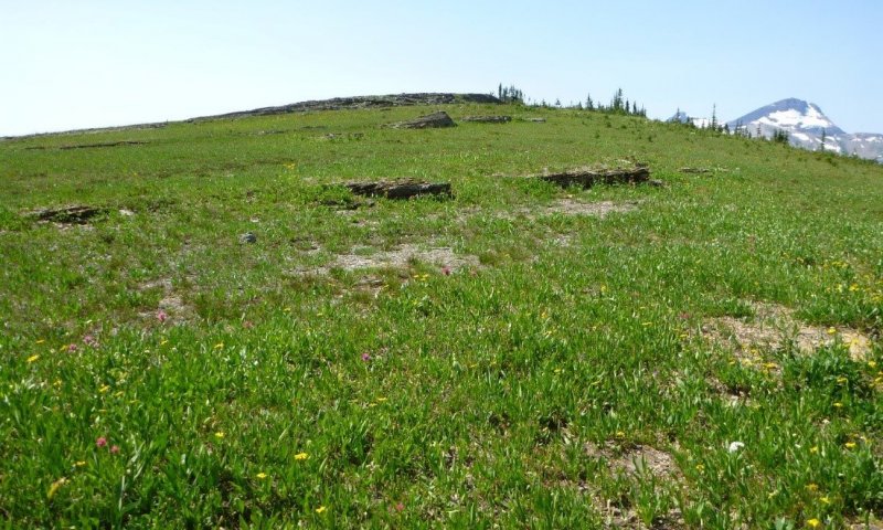
Figure 13. Close up of vegetation at this ecological site
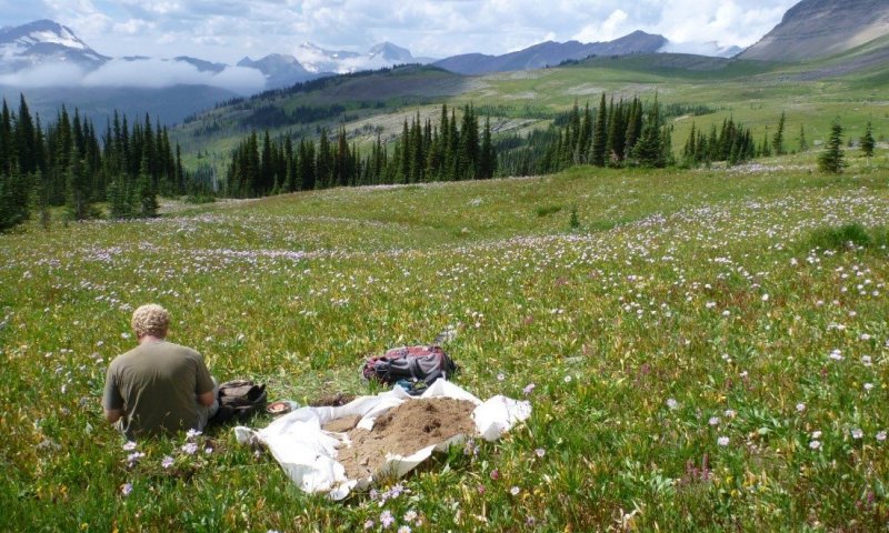
Figure 14. Community phase 1.1.
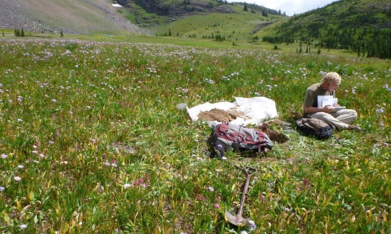
Figure 15. Close up view of plant species found at this ecological site at vegetative climax.
Yellow avalanche-lily (Erythronium grandiflorum)-Scouler’s St. Johnswort (Hypericum scouleri)-alpine leafybract aster (Symphyotrichum foliaceum)-Sitka valerian (Valeriana sitchensis)-heartleaf arnica (Arnica cordifolia)/Hitchcock’s smooth woodrush (Luzula glabrata var. hitchcockii)-shortstalk sedge (Carex podocarpa). This community phase has high foliar cover (76%) with low to moderate basal cover (5-15%). The lower basal area may be due to the numerous bloom and senesce rotations in this vegetation community and the fact that forb litter decomposes quickly compared to graminoid litter (Damm, 2001). For instance, lanceleaf springbeauty is a very early blooming species, completing the bloom and senesce cycle, with a very tiny basal area and may not be evident later in the season. The ground cover is predominantly litter (66%) though can have moderate cover of bare soil (6%) and trace amounts of bedrock, stones, cobbles, gravel and moss. The vegetation structure is a fairly uniform two layers, one 10-20 inches tall and another layer below 10 inches tall of diverse forb and grass species. The tallest common species, Alpine timothy (Phleum alpinum) can be 40 inches tall. Only thinleaf huckleberry which occurs sporadically and green false hellebore (Veratrum viride) can reach heights of 30 inches tall. The 10-20 inches tall layer can include sticky purple geranium (Geranium viscosissimum), yellow avalanche lily (Erythronium grandiflorum), broadleaf arnica (Arnica latifolia), aster, bromus and senecio species. The lower layer below 10 inches can include Payson’s sedge (Carex paysonis), Drummond’s rush (Juncus drummondii), shortstalk sedge (Carex podocarpa), Hitchcock’s smooth woodrush (Luzula glabrata var. hitchcockii), Scouler’s St. Johnswort (Hypericum scouleri), creeping sibbaldia (Sibbaldia procumbens) and other forbs and grasses. The species composition for production in pounds per acre averages to be: Payson's sedge is 19 percent, alpine leafybract aster is 14 percent, Scouler's St. Johnswort is 11 percent, Sitka valerian is 10 percent, Hitchcock's smooth woodrush is 9 percent, arnica species is 7 percent, geranium species is 7 percent, Drummond's rush is 5 percent, and broadleaf arnica is 4 percent.
Dominant plant species
-
Hitchcock's smooth woodrush (Luzula glabrata var. hitchcockii), grass
-
shortstalk sedge (Carex podocarpa), grass
-
yellow avalanche-lily (Erythronium grandiflorum), other herbaceous
-
Scouler's St. Johnswort (Hypericum scouleri ssp. scouleri), other herbaceous
-
alpine leafybract aster (Symphyotrichum foliaceum), other herbaceous
-
Sitka valerian (Valeriana sitchensis), other herbaceous
-
broadleaf arnica (Arnica latifolia), other herbaceous
Figure 16. Annual production by plant type (representative values) or group (midpoint values)
Table 7. Soil surface cover
| Tree basal cover | 0% |
|---|---|
| Shrub/vine/liana basal cover | 0-5% |
| Grass/grasslike basal cover | 0-10% |
| Forb basal cover | 0-20% |
| Non-vascular plants | 0-10% |
| Biological crusts | 0-5% |
| Litter | 30-60% |
| Surface fragments >0.25" and <=3" | 0-5% |
| Surface fragments >3" | 0-5% |
| Bedrock | 0% |
| Water | 0% |
| Bare ground | 20-50% |
Table 8. Canopy structure (% cover)
| Height Above Ground (m) | Tree | Shrub/Vine | Grass/ Grasslike |
Forb |
|---|---|---|---|---|
| <0.15 | – | 0-5% | 0-20% | 0-20% |
| >0.15 <= 0.3 | – | 0-5% | 0-20% | 0-20% |
| >0.3 <= 0.6 | – | – | 0-5% | 0-20% |
| >0.6 <= 1.4 | – | – | – | – |
| >1.4 <= 4 | – | – | – | – |
| >4 <= 12 | – | – | – | – |
| >12 <= 24 | – | – | – | – |
| >24 <= 37 | – | – | – | – |
| >37 | – | – | – | – |
Community 1.2
At-risk, human-impacted, lower biodiversity, higher erosion phase
This community has less foliar cover than community phase 1.1 due to grazing or trampling. There is an increase in bare ground cover and compaction of the soil. This community is at additional risk to crossing a threshold to State 2.0.
Community 1.3
Bear or rodent digging phase
This community has sustained bear digging in which the soil has been churned over, aerating the soil and exposing buried plant propagules. The recovery time from this small-scale disturbance is short. The seral progression is colonizing moss species, then Hitchcock’s smooth woodrush and perennial forb species re-establish on the site.
Pathway 1.1A
Community 1.1 to 1.2
This represents extensive animal trails or trampling by humans which lead to an increase in bare ground, compaction of soil, lowering of total foliar cover, change in species composition, and/or a lowering of total productivity of the site. Drought conditions would exacerbate the disturbance and lengthen recovery time. The disturbance may be extensive.
Pathway 1.1B
Community 1.1 to 1.3
This represents disturbance by bear digging and rodent burrowing, which lead to a churning of soil, aeration and exposure of buried plant propagules. This disturbance is small in area generally and the vegetation recovers quickly.
Pathway 1.2A
Community 1.2 to 1.1
This represents a resumption of production and composition by species to the reference state by a decrease in grazing or trampling by humans.
Pathway 1.3A
Community 1.3 to 1.1
This represents time without extensive bear digging in which the seral progression of colonizing moss species, Hitchcock’s smooth woodrush and perennial forb species re-establish on the site.
State 2
Altered
Intense grazing and/or human trampling with weedy species dominance. This community has sustained a dramatic reduction in foliar cover, species production or even a change in species composition from the Reference Community (1.1) due to intense grazing or trampling and an introduction, establishment and dominance of weedy species.
Community 2.1
Weedy Phase
This community has sustained a dramatic reduction in foliar cover, species production or even a change in species composition from the Reference Community (1.1) due to intense grazing or trampling and an introduction, establishment and dominance of weedy species. Structure: Low productivity, low foliar cover, species-poor, high cover of weedy species community with high cover of bare ground and soil compaction
Transition T1A
State 1 to 2
Extensive human trampling; Dramatic reduction in total foliar cover due to human trampling; increase in weedy species.
Restoration pathway R1A
State 2 to 1
Extensive time without disturbance; planting of native species; soil aeration, churning, amendments to decrease compaction and increase soil fertility.
Additional community tables
Table 9. Community 1.1 plant community composition
| Group | Common name | Symbol | Scientific name | Annual production (kg/hectare) | Foliar cover (%) | |
|---|---|---|---|---|---|---|
|
Forb
|
||||||
| 1 | Perennial and annual forbs | – | ||||
| alpine leafybract aster | SYFO2 | Symphyotrichum foliaceum | 0–1905 | 0–50 | ||
| Sitka valerian | VASI | Valeriana sitchensis | 0–1121 | 0–50 | ||
| sticky purple geranium | GEVI2 | Geranium viscosissimum | 0–1121 | 0–50 | ||
| Scouler's St. Johnswort | HYSCS2 | Hypericum scouleri ssp. scouleri | 0–1121 | 0–50 | ||
| arnica | ARNIC | Arnica | 0–673 | 0–10 | ||
| broadleaf arnica | ARLA8 | Arnica latifolia | 0–560 | 0–40 | ||
| aster | ASTER | Aster | 0–280 | 0–10 | ||
| creeping sibbaldia | SIPR | Sibbaldia procumbens | 0–112 | 0–10 | ||
| arrowleaf ragwort | SETR | Senecio triangularis | 0–112 | – | ||
| yellow avalanche-lily | ERGR9 | Erythronium grandiflorum | 0–67 | 0–5 | ||
| autumn dwarf gentian | GEAM3 | Gentianella amarella | 0–67 | 0–3 | ||
| castilla | CASTI | Castilla | 0–67 | 0–3 | ||
| beardtongue | PENST | Penstemon | 0–56 | 0–5 | ||
| Virginia strawberry | FRVI | Fragaria virginiana | 0–56 | 0–3 | ||
| goldenrod | SOLID | Solidago | 0–56 | – | ||
| lousewort | PEDIC | Pedicularis | 0–56 | – | ||
| subalpine fleabane | ERPE3 | Erigeron peregrinus | 0–22 | 0–20 | ||
| darkwoods violet | VIOR | Viola orbiculata | 0–22 | – | ||
| Rydberg's arnica | ARRY | Arnica rydbergii | – | 0–20 | ||
| Rocky Mountain groundsel | PAST10 | Packera streptanthifolia | – | 0–20 | ||
| arrowleaf ragwort | SETR | Senecio triangularis | – | 0–15 | ||
| Pacific anemone | ANMU | Anemone multifida | – | 0–10 | ||
| common yarrow | ACMI2 | Achillea millefolium | – | 0–10 | ||
| phacelia | PHACE | Phacelia | – | 0–5 | ||
| varileaf cinquefoil | PODI2 | Potentilla diversifolia | – | 0–5 | ||
| ragwort | SENEC | Senecio | – | 0–5 | ||
| valerian | VALER | Valeriana | – | 0–3 | ||
| lanceleaf springbeauty | CLLA2 | Claytonia lanceolata | – | 0–3 | ||
| pimpernel willowherb | EPAN4 | Epilobium anagallidifolium | – | 0–3 | ||
| Lyall's angelica | ANAR3 | Angelica arguta | – | 0–2 | ||
|
Grass/Grasslike
|
||||||
| 2 | Grasses, sedges, rushes | – | ||||
| Payson's sedge | CAPA31 | Carex paysonis | 0–1121 | 0–50 | ||
| Drummond's rush | JUDR | Juncus drummondii | 0–785 | 0–50 | ||
| Hitchcock's smooth woodrush | LUGLH | Luzula glabrata var. hitchcockii | 0–673 | 0–50 | ||
| alpine bluegrass | POAL2 | Poa alpina | 0–224 | 0–20 | ||
| shortstalk sedge | CAPO | Carex podocarpa | 0–224 | 0–10 | ||
| smallwing sedge | CAMI7 | Carex microptera | 0–168 | 0–25 | ||
| alpine timothy | PHAL2 | Phleum alpinum | 0–56 | 0–20 | ||
| Mertens' rush | JUME3 | Juncus mertensianus | 0–56 | 0–10 | ||
| wheatgrass | AGROP2 | Agropyron | 0–22 | – | ||
| alpine bentgrass | AGHU | Agrostis humilis | – | 0–5 | ||
| brome | BROMU | Bromus | – | 0–3 | ||
| Parry's rush | JUPA | Juncus parryi | – | 0–3 | ||
| curly sedge | CARU3 | Carex rupestris | – | 0–3 | ||
| Kentucky bluegrass | POPR | Poa pratensis | – | 0–2 | ||
|
Shrub/Vine
|
||||||
| 3 | Shrubs and subshrubs | – | ||||
| pink mountainheath | PHEM | Phyllodoce empetriformis | – | 0–2 | ||
Table 10. Community 1.1 forest understory composition
| Common name | Symbol | Scientific name | Nativity | Height (m) | Canopy cover (%) | |
|---|---|---|---|---|---|---|
|
Grass/grass-like (Graminoids)
|
||||||
| shortstalk sedge | CAPO | Carex podocarpa | – | – | 0.5–62.5 | |
| Hitchcock's smooth woodrush | LUGLH | Luzula glabrata var. hitchcockii | – | – | 1–40 | |
| sedge | CAREX | Carex | – | – | 0.5–37.5 | |
| curly sedge | CARU3 | Carex rupestris | – | – | 37.5 | |
| Payson's sedge | CAPA31 | Carex paysonis | – | – | 5–20 | |
| Geyer's sedge | CAGE2 | Carex geyeri | – | – | 1–15 | |
| smallwing sedge | CAMI7 | Carex microptera | – | – | 1–15 | |
| mountain brome | BRMA4 | Bromus marginatus | – | – | 3–15 | |
| fescue | FESTU | Festuca | – | – | 15 | |
| rush | JUNCU | Juncus | – | – | 0.5–15 | |
| bluegrass | POA | Poa | – | – | 0.5–10 | |
| alpine timothy | PHAL2 | Phleum alpinum | – | – | 0.5–5 | |
| Parry's rush | JUPA | Juncus parryi | – | – | 5 | |
| northern singlespike sedge | CASC10 | Carex scirpoidea | – | – | 1–5 | |
| black alpine sedge | CANI2 | Carex nigricans | – | – | 5 | |
| threadleaf sedge | CAFI | Carex filifolia | – | – | 3 | |
| blue wildrye | ELGL | Elymus glaucus | – | – | 0.5–3 | |
| Drummond's rush | JUDR | Juncus drummondii | – | – | 1–3 | |
| Mertens' rush | JUME3 | Juncus mertensianus | – | – | 1–3 | |
| timber oatgrass | DAIN | Danthonia intermedia | – | – | 2 | |
| low northern sedge | CACO10 | Carex concinna | – | – | 2 | |
| brome | BROMU | Bromus | – | – | 0.5 | |
| Idaho fescue | FEID | Festuca idahoensis | – | – | 0.5 | |
| timothy | PHPR3 | Phleum pratense | – | – | 0.5 | |
|
Forb/Herb
|
||||||
| nineleaf biscuitroot | LOTR2 | Lomatium triternatum | – | – | 62.5 | |
| yellow avalanche-lily | ERGR9 | Erythronium grandiflorum | – | – | 0.5–62.5 | |
| Indian paintbrush | CASTI2 | Castilleja | – | – | 0.5–62.5 | |
| common yarrow | ACMI2 | Achillea millefolium | – | – | 0.5–37.5 | |
| heartleaf arnica | ARCO9 | Arnica cordifolia | – | – | 0.5–37.5 | |
| arnica | ARNIC | Arnica | – | – | 0.5–37.5 | |
| Scouler's St. Johnswort | HYSCS2 | Hypericum scouleri ssp. scouleri | – | – | 0.5–37.5 | |
| bog laurel | KAPO | Kalmia polifolia | – | – | 0.5–37.5 | |
| desertparsley | LOMAT | Lomatium | – | – | 3–37.5 | |
| sticky purple geranium | GEVI2 | Geranium viscosissimum | – | – | 3–30 | |
| subalpine fleabane | ERPE3 | Erigeron peregrinus | – | – | 3–25 | |
| eightpetal mountain-avens | DROC | Dryas octopetala | – | – | 15 | |
| western showy aster | EUCO36 | Eurybia conspicua | – | – | 3–15 | |
| strawberry | FRAGA | Fragaria | – | – | 15 | |
| northern bedstraw | GABO2 | Galium boreale | – | – | 15 | |
| broadleaf arnica | ARLA8 | Arnica latifolia | – | – | 1–15 | |
| pussytoes | ANTEN | Antennaria | – | – | 0.5–15 | |
| Dawson's angelica | ANDA | Angelica dawsonii | – | – | 15 | |
| Pacific anemone | ANMU | Anemone multifida | – | – | 3–15 | |
| aster | ASTER | Aster | – | – | 3–15 | |
| bluebell bellflower | CARO2 | Campanula rotundifolia | – | – | 15 | |
| Asian forget-me-not | MYAS2 | Myosotis asiatica | – | – | 15 | |
| fringed grass of Parnassus | PAFI3 | Parnassia fimbriata | – | – | 0.5–15 | |
| twin arnica | ARSO2 | Arnica sororia | – | – | 7 | |
| splitleaf Indian paintbrush | CARH4 | Castilleja rhexiifolia | – | – | 0.5–5 | |
| rockcress | ARABI2 | Arabis | – | – | 0.5–5 | |
| Rocky Mountain groundsel | PAST10 | Packera streptanthifolia | – | – | 0.5–5 | |
| bracted lousewort | PEBR | Pedicularis bracteosa | – | – | 0.5–3 | |
| purple monkeyflower | MILE2 | Mimulus lewisii | – | – | 3 | |
| miterwort | MITEL | Mitella | – | – | 0.5–3 | |
| lupine | LUPIN | Lupinus | – | – | 3 | |
| slender mountain sandwort | ARCA7 | Arenaria capillaris | – | – | 1–3 | |
| sandwort | ARENA | Arenaria | – | – | 3 | |
| Lyall's rockcress | ARLY | Arabis lyallii | – | – | 3 | |
| rosy pussytoes | ANRO2 | Antennaria rosea | – | – | 0.5–3 | |
| onion | ALLIU | Allium | – | – | 3 | |
| wild chives | ALSC | Allium schoenoprasum | – | – | 0.5–3 | |
| arrowleaf balsamroot | BASA3 | Balsamorhiza sagittata | Native | – | 3 | |
| pimpernel willowherb | EPAN4 | Epilobium anagallidifolium | – | – | 3 | |
| narrowleaf hawkweed | HIUM | Hieracium umbellatum | – | – | 0.5–3 | |
| Richardson's geranium | GERI | Geranium richardsonii | – | – | 3 | |
| common cowparsnip | HEMA80 | Heracleum maximum | – | – | 0.5–3 | |
| onestem fleabane | ERSI3 | Erigeron simplex | – | – | 3 | |
| sulphur-flower buckwheat | ERUM | Eriogonum umbellatum | – | – | 3 | |
| brittle bladderfern | CYFR2 | Cystopteris fragilis | – | – | 3 | |
| fireweed | CHAN9 | Chamerion angustifolium | – | – | 0.5–3 | |
| white thistle | CIHO | Cirsium hookerianum | – | – | 3 | |
| maiden blue eyed Mary | COPA3 | Collinsia parviflora | – | – | 0.5–3 | |
| autumn dwarf gentian | GEAM3 | Gentianella amarella | – | – | 0.5–2 | |
| western Indian paintbrush | CAOC4 | Castilleja occidentalis | – | – | 0.5–2 | |
| gentian | GENTI | Gentiana | – | – | 1 | |
| cryptantha | CRYPT | Cryptantha | – | – | 1 | |
| coiled lousewort | PECO | Pedicularis contorta | – | – | 1 | |
| lousewort | PEDIC | Pedicularis | – | – | 0.5–1 | |
| western sweetroot | OSOC | Osmorhiza occidentalis | – | – | 0.5 | |
| locoweed | OXYTR | Oxytropis | – | – | 0.5 | |
| seep monkeyflower | MIGU | Mimulus guttatus | – | – | 0.5 | |
| phlox | PHLOX | Phlox | – | – | 0.5 | |
| field chickweed | CEAR4 | Cerastium arvense | – | – | 0.5 | |
| draba | DRABA | Draba | – | – | 0.5 | |
| Virginia strawberry | FRVI | Fragaria virginiana | – | – | 0.5 | |
| woolly hawkweed | HITR2 | Hieracium triste | – | – | 0.5 | |
| angelica | ANGEL | Angelica | – | – | 0.5 | |
| Rydberg's arnica | ARRY | Arnica rydbergii | – | – | 0.5 | |
|
Shrub/Subshrub
|
||||||
| shrubby cinquefoil | DAFR6 | Dasiphora fruticosa | – | – | 15 | |
| pink mountainheath | PHEM | Phyllodoce empetriformis | – | – | 0.5–15 | |
| alpine bluegrass | POAL2 | Poa alpina | – | – | 1–15 | |
| rusty menziesia | MEFE | Menziesia ferruginea | – | – | 3 | |
| varileaf cinquefoil | PODI2 | Potentilla diversifolia | – | – | 0.5 | |
| Saskatoon serviceberry | AMAL2 | Amelanchier alnifolia | – | – | 0.5 | |
|
Tree
|
||||||
| subalpine fir | ABLA | Abies lasiocarpa | – | 0–11.9 | 0.5–15 | |
| whitebark pine | PIAL | Pinus albicaulis | – | 0–11.9 | 0.5 | |
| Engelmann spruce | PIEN | Picea engelmannii | – | 0–11.9 | 0.5 | |
Table 11. Community 1.2 forest understory composition
| Common name | Symbol | Scientific name | Nativity | Height (m) | Canopy cover (%) | |
|---|---|---|---|---|---|---|
|
Grass/grass-like (Graminoids)
|
||||||
| shortstalk sedge | CAPO | Carex podocarpa | – | – | 3–37.5 | |
| sedge | CAREX | Carex | – | – | 15 | |
| threadleaf sedge | CAFI | Carex filifolia | – | – | 15 | |
| Drummond's rush | JUDR | Juncus drummondii | – | – | 3–15 | |
| rush | JUNCU | Juncus | – | – | 3–15 | |
| Hitchcock's smooth woodrush | LUGLH | Luzula glabrata var. hitchcockii | – | – | 3–15 | |
| northwestern sedge | CACO11 | Carex concinnoides | – | – | 15 | |
| spike trisetum | TRSP2 | Trisetum spicatum | – | – | 3 | |
| bluegrass | POA | Poa | – | – | 3 | |
| alpine bluegrass | POAL2 | Poa alpina | – | – | 3 | |
| alpine timothy | PHAL2 | Phleum alpinum | – | – | 3 | |
| blue wildrye | ELGL | Elymus glaucus | – | – | 3 | |
| Geyer's sedge | CAGE2 | Carex geyeri | – | – | 3 | |
| smallwing sedge | CAMI7 | Carex microptera | – | – | 3 | |
|
Forb/Herb
|
||||||
| arnica | ARNIC | Arnica | – | – | 3–37.5 | |
| alpine leafybract aster | SYFO2 | Symphyotrichum foliaceum | – | – | 15–37.5 | |
| slender cinquefoil | POGR9 | Potentilla gracilis | – | – | 15 | |
| sibbaldia | SIBBA | Sibbaldia | – | – | 15 | |
| Sitka valerian | VASI | Valeriana sitchensis | – | – | 15 | |
| aster | ASTER | Aster | – | – | 3–15 | |
| rosy pussytoes | ANRO2 | Antennaria rosea | – | – | 3–15 | |
| Rainier pleated gentian | GECA | Gentiana calycosa | – | – | 15 | |
| Scouler's St. Johnswort | HYSCS2 | Hypericum scouleri ssp. scouleri | – | – | 0.5–15 | |
| stitchwort | MINUA | Minuartia | – | – | 3 | |
| narrowleaf hawkweed | HIUM | Hieracium umbellatum | – | – | 3 | |
| yellow avalanche-lily | ERGR9 | Erythronium grandiflorum | – | – | 3 | |
| western showy aster | EUCO36 | Eurybia conspicua | – | – | 3 | |
| pussytoes | ANTEN | Antennaria | – | – | 3 | |
| heartleaf arnica | ARCO9 | Arnica cordifolia | – | – | 0.5–3 | |
| common yarrow | ACMI2 | Achillea millefolium | – | – | 3 | |
| wild chives | ALSC | Allium schoenoprasum | – | – | 3 | |
| bellflower | CAMPA | Campanula | – | – | 3 | |
| splitleaf Indian paintbrush | CARH4 | Castilleja rhexiifolia | – | – | 3 | |
| green false hellebore | VEVI | Veratrum viride | – | – | 3 | |
| common beargrass | XETE | Xerophyllum tenax | – | – | 3 | |
| creeping sibbaldia | SIPR | Sibbaldia procumbens | – | – | 3 | |
| cinquefoil | POTEN | Potentilla | – | – | 0.5–3 | |
| phlox | PHLOX | Phlox | – | – | 0.5–3 | |
| arrowleaf ragwort | SETR | Senecio triangularis | – | – | 3 | |
| American bistort | POBI6 | Polygonum bistortoides | – | – | 3 | |
| Rocky Mountain groundsel | PAST10 | Packera streptanthifolia | – | – | 0.5 | |
| Indian paintbrush | CASTI2 | Castilleja | – | – | 0.5 | |
| anemone | ANEMO | Anemone | – | – | 0.5 | |
| sandwort | ARENA | Arenaria | – | – | 0.5 | |
| strawberry | FRAGA | Fragaria | – | – | 0.5 | |
| gentian | GENTI | Gentiana | – | – | 0.5 | |
| nineleaf biscuitroot | LOTR2 | Lomatium triternatum | – | – | 0.5 | |
|
Shrub/Subshrub
|
||||||
| pink mountainheath | PHEM | Phyllodoce empetriformis | – | – | 3 | |
| thinleaf huckleberry | VAME | Vaccinium membranaceum | – | – | 3 | |
| yellow mountainheath | PHGL6 | Phyllodoce glanduliflora | – | – | 3 | |
| grouse whortleberry | VASC | Vaccinium scoparium | – | – | 0.5 | |
| arctic willow | SAAR27 | Salix arctica | – | – | 0.5 | |
|
Tree
|
||||||
| subalpine fir | ABLA | Abies lasiocarpa | – | – | 3 | |
| whitebark pine | PIAL | Pinus albicaulis | – | – | 0.5 | |
|
Nonvascular
|
||||||
| Moss | 2MOSS | Moss | – | – | 0.5–15 | |
Interpretations
Supporting information
Other references
References
Agee, James K. 1993. Fire ecology of Pacific Northwest forests. Washington, DC: Island Press. 493 p.
Arno, Stephen F. Forest regions of Montana. Intermountain Forest and Range Experiment Station, 1979.
Asebrook, J. 2010. Glacier National Park: Eastside Grasslands Ecology Project
Cole, D. 1985. Recreational trampling effects on six habitat types in western Montana. Research paper INT-350.
Damm, Christian. 2001. A phytosociological study of Glacier National Park, Montana, USA, with notes on the syntaxonomy of alpine vegetation in western North America.
Ellison, Lincoln. 1954. Subalpine vegetation of the Wasatch Plateau, Utah. Ecological Monographs. 24: 89-184.
Hansen, Paul L.; Pfister, Robert D.; Boggs, Keith; [and others]. 1995. Classification and management of Montana's riparian and wetland sites. Miscellaneous Publication No. 54. Missoula, MT: The University of Montana, School of Forestry, Montana Forest and Conservation Experiment Station. 646 p.
Hartley, Ernest. Thirty-year monitoring of Subalpine Meadow vegetation following a 1967 trampling experiment at Logan Pass, Glacier National Park, Montana.
In: Cole, David N.; McCool, Stephen F.; Borrie, William T.; O’Loughlin,Jennifer, comps. 2000. Wilderness science in a time of change conference—Volume 5: Wilderness ecosystems, threats, and management; 1999 May 23–27; Missoula, MT. Proceedings RMRS-P-15-VOL-5. Ogden, UT: U.S. Department of Agriculture, Forest Service, Rocky Mountain Research Station.
Lambert, A., Abraham Miller-Rushing, David Inouye. Changes in snowmelt date and summer precipitation affect the flowering phenology of Erythronium grandiflorum. American Journal of Botany 97(9): 1431-1437.2010.
Landals, M. and Scotter, G. An ecological assessment of the Summit Area, Mount Revelstoke National Park. Edmonton, AB: Canadian Wildlife Service; 1974. 197 p.
Lesica, Peter. Flora of Glacier National Park, Montana. Oregon State University Press, 2002.
NatureServe, 2007. U.S. National Vegetation Classification Standard: Terrestrial Ecological Classifications. Waterton-Glacier International Peace Park, Local and Global Association Descriptions.
U.S. Department of Agriculture, Forest Service, Missoula Fire Sciences Laboratory. 2012. Information from LANDFIRE on fire regimes of northwestern high-elevation grassland communities. In: Fire Effects Information System, [Online]. U.S.
Department of Agriculture, Forest Service, Rocky Mountain Research Station, Missoula Fire Sciences Laboratory (Producer). Available: http://www.fs.fed.us/database/feis/fire_regimes/NW_high_elevation_grass/all.html [ 2016, September 8].
Soil Survey Staff. 2015. Illustrated guide to soil taxonomy. U.S. Department of Agriculture, Natural Resources Conservation Service, National Soil Survey Center, Lincoln, Nebraska.
Tardiff, S. and J. Standford. 1998. Grizzly bear digging: effects on subalpine meadow plants in relation to mineral nitrogen availability. Ecology. 79 (7). pp. 2219-2228.
Tyser, Robin W. (1989) "Ecology of Fescue Grasslands in Glacier National Park," University of Wyoming National Park Service Research Center Annual Report: Vol. 13, Article 12.
Available at: http://repository.uwyo.edu/uwnpsrc_reports/vol13/iss1/12
Approval
Kirt Walstad, 4/10/2025
Rangeland health reference sheet
Interpreting Indicators of Rangeland Health is a qualitative assessment protocol used to determine ecosystem condition based on benchmark characteristics described in the Reference Sheet. A suite of 17 (or more) indicators are typically considered in an assessment. The ecological site(s) representative of an assessment location must be known prior to applying the protocol and must be verified based on soils and climate. Current plant community cannot be used to identify the ecological site.
| Author(s)/participant(s) | |
|---|---|
| Contact for lead author | |
| Date | 12/18/2020 |
| Approved by | Kirt Walstad |
| Approval date | |
| Composition (Indicators 10 and 12) based on | Annual Production |
Indicators
-
Number and extent of rills:
-
Presence of water flow patterns:
-
Number and height of erosional pedestals or terracettes:
-
Bare ground from Ecological Site Description or other studies (rock, litter, lichen, moss, plant canopy are not bare ground):
-
Number of gullies and erosion associated with gullies:
-
Extent of wind scoured, blowouts and/or depositional areas:
-
Amount of litter movement (describe size and distance expected to travel):
-
Soil surface (top few mm) resistance to erosion (stability values are averages - most sites will show a range of values):
-
Soil surface structure and SOM content (include type of structure and A-horizon color and thickness):
-
Effect of community phase composition (relative proportion of different functional groups) and spatial distribution on infiltration and runoff:
-
Presence and thickness of compaction layer (usually none; describe soil profile features which may be mistaken for compaction on this site):
-
Functional/Structural Groups (list in order of descending dominance by above-ground annual-production or live foliar cover using symbols: >>, >, = to indicate much greater than, greater than, and equal to):
Dominant:
Sub-dominant:
Other:
Additional:
-
Amount of plant mortality and decadence (include which functional groups are expected to show mortality or decadence):
-
Average percent litter cover (%) and depth ( in):
-
Expected annual annual-production (this is TOTAL above-ground annual-production, not just forage annual-production):
-
Potential invasive (including noxious) species (native and non-native). List species which BOTH characterize degraded states and have the potential to become a dominant or co-dominant species on the ecological site if their future establishment and growth is not actively controlled by management interventions. Species that become dominant for only one to several years (e.g., short-term response to drought or wildfire) are not invasive plants. Note that unlike other indicators, we are describing what is NOT expected in the reference state for the ecological site:
-
Perennial plant reproductive capability:
Print Options
Sections
Font
Other
The Ecosystem Dynamics Interpretive Tool is an information system framework developed by the USDA-ARS Jornada Experimental Range, USDA Natural Resources Conservation Service, and New Mexico State University.
Click on box and path labels to scroll to the respective text.