Ecological dynamics
It is impossible to determine in any quantitative detail the historic climax plant community (HCPC) for this ecological site because of the lack of direct historical documentation preceding all human influence. In some areas, the earliest reports of dominant plants include the cadastral survey conducted by the General Land Office, which began in the late 19th century for this area (Galatowitsch 1990). However, up to the 1870s the Shoshone Indians, prevalent in northern Utah and neighboring states, grazed horses and set fires to alter the vegetation for their needs (Parson 1996). In the 1860s, Europeans brought cattle and horses to the area, grazing large numbers of them on unfenced parcels year-long (Parson 1996). Itinerant and local sheep flocks followed, largely replacing cattle as the browse component increased.
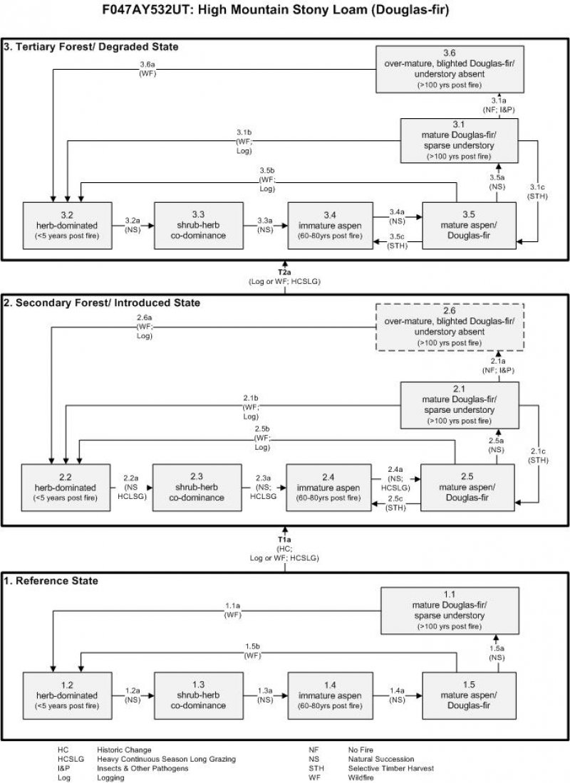
Below is a State and Transition Model diagram to illustrate the “phases” (common plant communities), and “states” (aggregations of those plant communities) that can occur on the site. Differences between phases and states depend primarily upon observations of a range of disturbance histories in areas where this ESD is represented. These situations include grazing gradients to water sources, fence-line contrasts, patches with differing dates of fire, herbicide treatment, tillage, and kinds and times of timber harvest, etc. Reference State 1 illustrates the common plant communities that probably existed just prior to European settlement.
The major successional pathways within states, (“community pathways”) are indicated by arrows between phases. “Transitions” are indicated by arrows between states. The drivers of these changes are indicated in codes decipherable by referring to the legend at the bottom of the page and by reading the detailed narratives that follow the diagram. The transition between Reference State 1 and State 2 is considered irreversible because of the naturalization of exotic species of both flora and fauna, possible extinction of native species, and climate change. There may have also been accelerated soil erosion.
When available, monitoring data (of various types) were employed to validate more subjective inferences made in this diagram. See the complete files in the office of the State Range Conservationist for more details.
State 1
Reference State
The Reference State is a description of this ecological site just prior to Euro-American settlement but long after the arrival of Native Americans. The description of the Reference State was determined by NRCS Soil Survey Type Site Location information and familiarity with relict areas where they exist. At the time of European colonization, what would have been observed on these sites would have primarily depended on the time since the last wildfire occurred. If fire had not occurred for about 100 years, Douglas-fir (Pseudotsuga menziesii) would have been the dominant species occupying the site, with a sparse shade-tolerant understory (1.1) due to tree competition, overstory shading, and duff accumulation. Douglas-fir replaces itself without wildfire and was the climatic climax. Wildfire (1.1a) would have temporarily replaced these stands with a rich diversity of herb-dominated vegetation. (1.2). In the absence of any major disturbance (1.2a, 1.3a, 1.4a, 1.5a), the vegetation would have progressed first into more of a shrub-herb co-dominance (1.3), followed by the increasing presence of aspen (Populus tremuloides) first as seedlings and saplings (1.4), and later as mature aspen with Douglas-fir seedlings (1.5). Ultimately Douglas-fir would have outcompeted aspen, returning to the climax vegetation (1.1). Wildfire (1.1a, 1.5b) would have been the primary disturbance factor prior to colonization. Early successional stages were shorter in duration. A more complete list of species by lifeform for the Reference State is available in the accompanying tables in the “Plant Community Composition by Weight and Percentage” section of this document.
Community 1.1
Reference State
Community Phase 1.1: mature Douglas-fir/ diminished understory
This plant community (1.1) would have been characterized by a stand of mature Douglas-fir with a sparse understory of Geyer’s sedge (Carex geyeri), bluegrass (Poa spp.), and shade tolerant herbs.
Community Pathway 1.1a:
Wildfire would have removed the trees, allowing shade-intolerant herbs to flourish briefly.
Community Phase 1.2: herb-dominated
This plant community would have developed within the first 5 years following fire.
Geyer’s sedge, bluegrass, slender wheatgrass (Elymus trachycaulus), would have been the dominant species, along with shade intolerant herbs.
Community Pathway 1.2a:
After about 5 years, shrubs would begin to establish in the site.
Community Phase 1.3: shrub-herb co-dominance
Between 5 and 60 years after fire, shrubs and herbs would co-dominate the site. The increasing shrub component would have included mountain snowberry (Symphoricarpos oreophilus), chokecherry (Prunus virginiana), Saskatoon serviceberry (Amelanchier alnifolia), and Oregon boxleaf (Paxistima myrsinites), among others.
Community Pathway 1.3a:
About 60 years after fire, aspen would become established in the site.
Community Phase 1.4: immature aspen
This plant community would have been dominated by a stand of immature aspen, a seral species, while Douglas-fir begun to establish itself under other nurse species. A stand of immature aspen would have existed approximately 60 to 80 years following the last fire.
Community Pathway 1.4a:
Aspen would have continued to mature while Douglas-fir would have become well established in the understory.
Community Phase 1.5: mature aspen/ Douglas-fir
A stand of mature aspen intermixed with Douglas-fir saplings would have been encountered approximately 80 to 100 years post fire.
Community Pathway 1.5a:
After about 100 years following the last fire, Douglas-fir would become mature, shading out aspen and the shade-intolerant shrub and herb species in the understory.
Community Pathway 1.5b:
Wildfire would have removed the trees, allowing shade-intolerant herbs to flourish briefly.
Transition T1a: from State 1 to State 2 (Reference State to Secondary Forest/ Introduced State)
The simultaneous introduction of exotic species, both plants and animals, and possible extinctions of native flora and fauna, along with climate change, has caused State 1 to transition to State 2. Europeans further altered this vegetation largely through logging, fuel wood harvest, livestock grazing, trapping of beaver, and changing the fire regime. Continued impacts could prevent the recovery toward potential conifer dominance (State 2, various phases). The reversal of these changes (i.e. a return pathway) back to State 1 is not practical.
a. Nature of Forest Community
The overstory tree canopy cover is 30 to 40 percent. Common understory plants are Geyer sedge, wheeler bluegrass, heartleaf arnica, chokecherry, canyon maple and creeping Oregon grape. Understory composition by air-dry weight is about 25 percent perennial grasses and grasslike plants, 10 percent forbs, and 65 percent shrubs. Understory production ranges from 500 pounds per acre in favorable years to about 100 pounds per acre in unfavorable years. Understory production includes the total annual production of all species within 4 ½ feet of the ground surface.
b. Productivity Rating of Major Understory Species:
Productivity Rating Index: This rating provides an index to the relative importance of species in the understory community as affected by overstory canopy cover.
Table 5. Annual production by plant type
| Plant type |
Low
(lb/acre) |
Representative value
(lb/acre) |
High
(lb/acre) |
| Shrub/Vine |
65 |
195 |
325 |
| Grass/Grasslike |
25 |
75 |
125 |
| Forb |
10 |
30 |
50 |
| Total |
100 |
300 |
500 |
State 2
Secondary Forest/ Introduced State
Community 2.1
Secondary Forest/ Introduced State
State 2 is similar to State 1 in form and function, with the exception of the presence of non-native plants and animals, possible extinctions of native species, a different climate, and a secondary stand of trees. State 2 is a description of the ecological site shortly following Euro-American settlement. This state can be regarded as the current potential. With the least amount of disturbance or manipulation of the fire regime, a mature stand of Douglas-fir with a sparse understory component is expected at this site (2.1) (Alexander 1985, 1988). As with the Reference State, time since last wildfire remains the key factor in determining what vegetation will be encountered on these sites. Wildfire, particularly crown fires, or complete harvesting of the forest (2.1b, 2.5b, 2.6a) will replace these stands with a rich diversity of herb-dominated vegetation. (2.2). In the absence of any major disturbance (2.2a, 2.3a, 2.4a, 2.5a), the vegetation will develop further into more of a shrub-herb co-dominance (2.3), followed by the increasing presence of aspen, first as seedlings and saplings (2.4), and later as mature aspen with immature Douglas-fir (2.5). Ultimately Douglas-fir will out-compete aspen, returning the site to the climax vegetation (2.1). In some areas where wildfire has been prevented, Douglas-fir trees may become over-mature (2.6) and consequently are more susceptible to infestation by insects and other pathogens (2.1a). The resiliency of this State can be maintained by moderating human uses of the forest for timber and/or grazing.
Community Phase 2.1: mature Douglas-fir/ sparse understory
This plant community (2.1) is characterized by a stand of mature Douglas-fir with a sparse understory of Geyer’s sedge and bluegrass. Shade-tolerant forbs may also be present.
Community Pathway 2.1a:
With fire exclusion, or well over 100 years since last fire, a Douglas-fir stand will ultimately deteriorate (become over-mature) and become increasingly susceptible to infestation by insects or other pathogens.
Community Pathway 2.1b:
A stand-replacing wildfire or intensive logging will set the vegetation back to an early seral herb-dominated phase. Logging opens up the forest canopy, allowing shade-intolerant herbs and shrubs to flourish for 20 to 30 years.
Community Pathway 2.1c:
The removal of only the mature Douglas-fir will allow some aspen to return and the immature Douglas-fir to continue growing.
Community Phase 2.2: herb-dominated
This plant community will develop within the first 5 years following the last fire or complete tree removal. Dominant grasses are Geyer’s sedge, bluegrass, slender wheatgrass; shade-intolerant forbs are also present. A small component of introduced species, and many annuals, may be present.
Community Pathway 2.2a:
The combination of heavy season long livestock grazing and fire exclusion will accelerate woody plant (shrub) establishment and diminish the herbaceous understory.
Community Phase 2.3: shrub-herb co-dominance
A plant community co-dominated by shrubs and herbs will develop approximately 5 to 60 years following fire or complete tree removal. A small component of introduced species may be present.
Community Pathway 2.3a:
The combination of heavy season long livestock grazing and fire exclusion will accelerate woody plant establishment and diminish the herbaceous understory.
Community Phase 2.4: immature aspen
Aspen will establish in the site 60 to 80 years after the last fire or complete tree removal.
Community Pathway 2.4a:
The combination of heavy season long livestock grazing and fire exclusion will accelerate woody plant establishment and diminish the understory.
Community Phase 2.5: mature aspen/ Douglas-fir
A stand of mature aspen intermixed with Douglas-fir will develop approximately 80 to 100 years following fire or complete tree removal.
Community Pathway 2.5a:
The combination of heavy season long livestock grazing and fire exclusion will accelerate woody plant establishment and diminish the understory.
Community Pathway 2.5b:
A stand-replacing wildfire or intensive logging will set the vegetation back to an early seral herb-dominated phase. Logging opens up the forest canopy allowing grasses, herbs, and shrubs to flourish for 20 to 30 years.
Community Pathway 2.5c:
The removal of mature aspen will leave a stand of immature aspen, possibly with a few Douglas-fir in the understory.
Community Phase 2.6: over-mature, blighted Douglas-fir/ understory absent
This plant community is the result of fire exclusion for well over 100 years. The Douglas-fir is over-mature and weakened, making it susceptible to infestation by insects or other pathogens.
Community Pathway 2.6a:
A stand-replacing wildfire will set the vegetation back to an early seral herb-dominated phase.
Transition T2a: from State 2 to State 3 (from Secondary Forest/ Introduced State to Tertiary Forest/ Degraded State)
The Secondary Forest/ Introduced State will transition to the Tertiary Forest/ Degraded State following a second cycle of timber harvest or a stand replacing wildfire and further impacts from heavy continuous season-long grazing. Logging opens up the forest canopy, allowing shade-intolerant species to flourish for 20 to 30 years. Secondary and tertiary disturbances can produce an array of vegetation from degraded temporary meadows to further simplified forests. The approach to this transition is indicated by a loss of species diversity, discontinuous litter and duff coverage, and evidence of accelerated soil erosion. This transition is triggered by excessive human utilization of the most economically desirable parts of the vegetation.
State 3
Tertiary Forest/ Degraded State
Community 3.1
Tertiary Forest/ Degraded State
State 3 is characterized by tertiary forests in which both the understory vegetation and tree condition have been degraded. Fire suppression accelerates the development of woody plant dominance.
Community Phase 3.1: mature Douglas-fir/ sparse understory
This plant community (3.1) is characterized by a stand of mature Douglas-fir. A sparse understory of Geyer’s sedge, bluegrass, and shade-tolerant forbs may be present.
Community Pathway 3.1a:
With fire exclusion, or well over 100 years since last fire, a Douglas-fir stand will ultimately deteriorate and become increasingly susceptible to infestation by insects or other pathogens.
Community Pathway 3.1b:
A stand-replacing wildfire or intensive logging will set the vegetation back to an early seral herb-dominated phase. Logging opens up the forest canopy, allowing shade-intolerant grasses, forbs, and shrubs to flourish for 20 to 30 years.
Community Pathway 3.1c:
The removal of only the mature Douglas-fir will allow aspen to return and the immature Douglas-fir to continue growing.
Community Phase 3.2: herb-dominated
This plant community will develop within the first 5 years following the last fire or complete tree removal. Dominant grasses are Geyer’s sedge, bluegrass, and slender wheatgrass. Shade intolerant forbs will also be present. A small component of introduced species may be present.
Community Pathway 3.2a:
After about 5 years, shrubs will begin to establish in the site.
Community Phase 3.3: shrub-herb co-dominance
A plant community co-dominated by shrubs and herbs will develop approximately 5 to 60 years after fire or complete tree removal. A small component of introduced species may be present.
Community Pathway 3.3a:
Aspen will become established at the site after 60-80 years following the last wildfire or complete tree removal.
Community Phase 3.4: immature aspen
Immature aspen dominate the stand 60 to 80 years following the last fire or complete tree removal.
Community Pathway 3.4a:
Aspen matures and immature Douglas-fir become well established in the understory 80 years after the last fire or complete tree removal.
Community Phase 3.5: mature aspen/ Douglas-fir
A stand of mature aspen intermixed with Douglas-fir will develop approximately 80 to 100 years following fire.
Community Pathway 3.5a:
After about 100 years following the last fire, Douglas-fir will become mature, shading out aspen and the shade-intolerant shrub and herb species in the understory.
Community Pathway 3.5b:
A stand-replacing wildfire or intensive logging will set the vegetation back to an early seral herb-dominated phase. Logging opens up the forest canopy, allowing grasses, herbs, and shrubs to dominate for 20 -30 years.
Community Pathway 3.5c:
The removal of mature aspen will leave a stand of immature aspen, possibly with a few Douglas-fir in the understory.
Community Phase 3.6: over-mature, blighted Douglas-fir/ understory absent
This plant community is the result of fire exclusion for well over 100 years. The Douglas-fir is over-mature and weakened, making it more susceptible to infestation by insects or other pathogens.
Community Pathway 3.6a:
A stand-replacing wildfire will set the vegetation back to an early seral herb-dominated phase.