Natural Resources
Conservation Service
Ecological site R047XA432UT
Mountain Loam (oak)
Last updated: 2/05/2025
Accessed: 04/01/2026
General information
Provisional. A provisional ecological site description has undergone quality control and quality assurance review. It contains a working state and transition model and enough information to identify the ecological site.
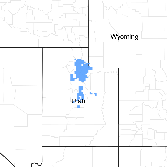
Figure 1. Mapped extent
Areas shown in blue indicate the maximum mapped extent of this ecological site. Other ecological sites likely occur within the highlighted areas. It is also possible for this ecological site to occur outside of highlighted areas if detailed soil survey has not been completed or recently updated.
MLRA notes
Major Land Resource Area (MLRA): 047X–Wasatch and Uinta Mountains
MLRA 47 occurs in Utah (86 percent), Wyoming (8 percent), Colorado (4 percent), and Idaho (2 percent). It encompasses approximately 23,825 square miles (61,740 square kilometers). The northern half of this area is in the Middle Rocky Mountains Province of the Rocky Mountain System. The southern half is in the High Plateaus of the Utah Section of the Colorado Plateaus Province of the Intermontane Plateaus. Parts of the western edge of this MLRA are in the Great Basin Section of the Basin and Range Province of the Intermontane Plateaus. The MLRA includes the Wasatch Mountains, which trend north and south, and the Uinta Mountains, which trend east and west. The steeply sloping, precipitous Wasatch Mountains have narrow crests and deep valleys. Active faulting and erosion are a dominant force in controlling the geomorphology of the area. The Uinta Mountains have a broad, gently arching, elongated shape. Structurally, they consist of a broadly folded anticline that has an erosion-resistant quartzite core. The Wasatch and Uinta Mountains have an elevation of 4,900 to about 13,500 feet (1,495 to 4,115 meters).
The mountains in this area are primarily fault blocks that have been tilted up. Alluvial fans at the base of the mountains are recharge zones for the basin fill aquifers. An ancient shoreline of historic Bonneville Lake is evident on the footslopes along the western edge of the area. Rocks exposed in the mountains are mostly Mesozoic and Paleozoic sediments, but Precambrian rocks are exposed in the Uinta Mountains. The Uinta Mountains are one of the few ranges in the United States that are oriented west to east. The southern Wasatch Mountains consist of Tertiary volcanic rocks occurring as extrusive lava and intrusive crystalline rocks.
The average precipitation is from 8 to 16 inches (203 to 406 mm) in the valleys and can range up to 73 inches (1854 mm) in the mountains. In the northern and western portions of the MLRA, peak precipitation occurs in the winter months. The southern and eastern portions have a greater incidence of high-intensity summer thunderstorms; hence, a significant amount of precipitation occurs during the summer months. The average annual temperature is 30 to 50 degrees Fahrenheit (-1 to 15 C). The freeze-free period averages 140 days and ranges from 60 to 220 days, generally decreasing in length with elevation.
The dominant soil orders in this MLRA are Aridisols, Entisols, Inceptisols, and Mollisols. The lower elevations are dominated by a frigid temperature regime, while the higher elevations experience cryic temperature regimes. Mesic temperature regimes come in on the lower elevations and south facing slopes in the southern portion of this MLRA. The soil moisture regime is typically xeric in the northern part of the MLRA, but grades to ustic in the extreme eastern and southern parts. The minerology is generally mixed and the soils are very shallow to very deep, generally well drained, and loamy or loamy –skeletal.
LRU notes
Major Land Resource Unit 47A is located in the northern half of the Middle Rocky Mountains Province of the Rocky Mountain System. This MLRA includes the Wasatch Mountains which tend to run north and south. These steeply sloping, precipitous mountains have narrow crests and deep valleys. They are primarily fault blocks that have been tilted up. The alluvial fans located at the base of these mountains are important recharge zones for valley aquifers.
Ecological site concept
The soils in this site are moderately deep and deep, well-drained, and have dark colored surface layers. They are underlain by medium to fine textured layers that may contain gravel and cobble. Some soils may have lime layers below about 36 inches, but the overlying soil is usually non-calcareous. They formed on gently sloping to very steep mountain slopes and hilly plateaus in materials weathered from sandstone, shale, limestone, quartzite, and igneous rocks. Intake rate is moderate and water movement through the soil is moderate to slow. Roots penetrate the soil readily. These soils have a high water-holding capacity that ranges from about 5 to 7 inches in a 40 inch profile. Rock fragments are variable throughout the profile, but average less than 30 percent by volume. Stone or cobble may occur as a surface mantle. Under proper management, these soils have little surface runoff and light or no erosion.
Associated sites
| R047XA406UT |
Mountain Gravelly Loam (mountain big sagebrush) |
|---|---|
| R047XA448UT |
Mountain Shallow Loam (oak) |
| R047XA471UT |
Mountain Very Steep Stony Loam (oak) |
| R047XA430UT |
Mountain Loam (mountain big sagebrush) R047XA430UT is the Mountain loam (Mountain big sagebrush) site. It is often found in a mosaic with this site. Gambel oak rarely propagates from seed in its northern ranges, and mountain big sagebrush cannot invade an oak stand. The result is a sharp mosaic of oak and sagebrush sites that changes very slowly if at all. |
Similar sites
| R047XA410UT |
Mountain Gravelly Loam (oak) R047XA410UT is the Mountain gravelly loam (Gambel oak) site. It produces smaller trees and more grass, and typically has a greater amount of annual production than this site. |
|---|---|
| R047XA418UT |
Mountain Loam (bigtooth maple) |
| R047XA448UT |
Mountain Shallow Loam (oak) |
| R047XA463UT |
Mountain Stony Loam (Gambel oak) |
| R047XA471UT |
Mountain Very Steep Stony Loam (oak) |
| R047XA473UT |
Mountain Very Steep Stony Loam (browse) |
Table 1. Dominant plant species
| Tree |
Not specified |
|---|---|
| Shrub |
(1) Quercus gambelii |
| Herbaceous |
Not specified |
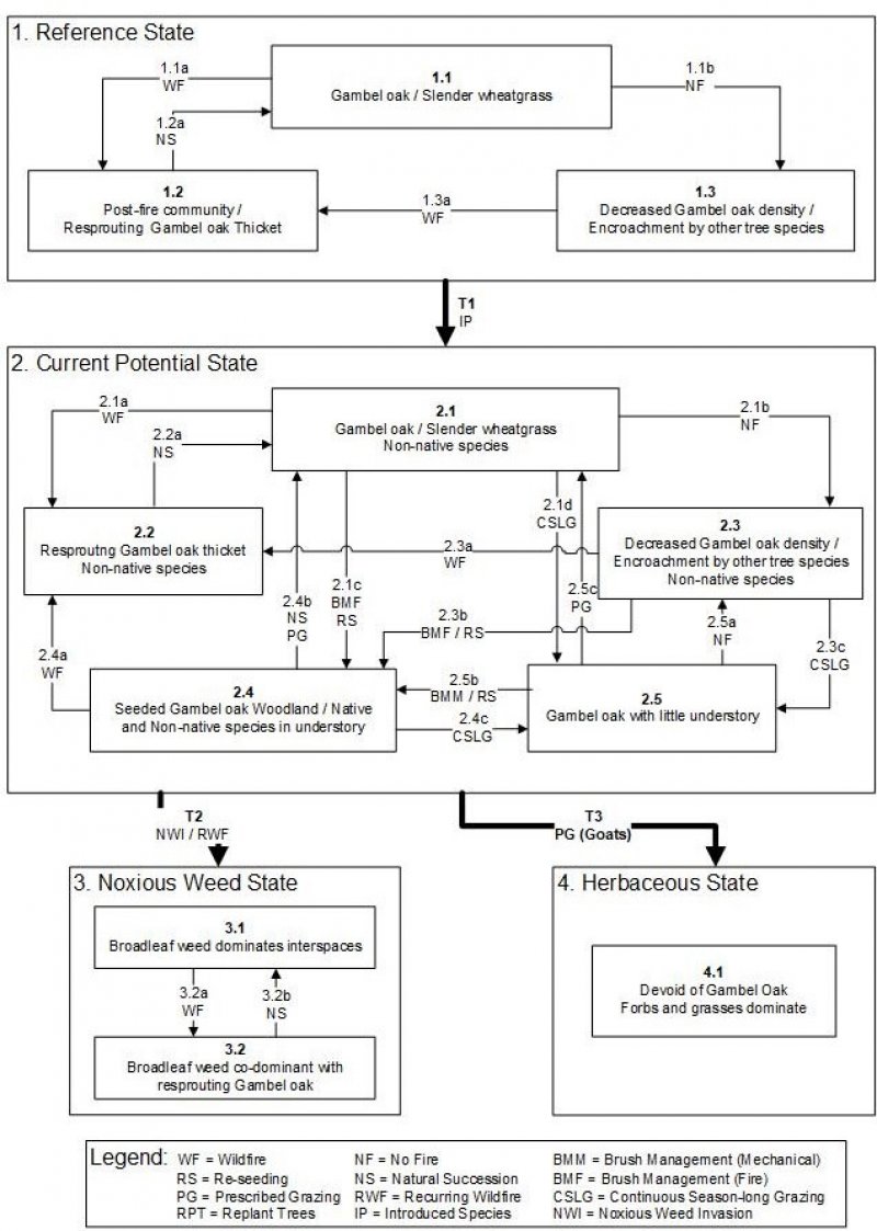
Click on box and path labels to scroll to the respective text.