Ecological dynamics
This site is characterized by gambel oak dominance with perennial bunchgrasses and forbs in the interspaces. Historically, wildfires rejuvenated aging oak stands every 40 to 80 years on this site. Gambel oak resprouts vigorously after fire and oak stem density decreases steadily as time without wildfire increases. On higher elevation sites, mature oak can be invaded by juniper or Douglas-fir. These resinous conifers increase the likelihood of wildfire which removes the invaders and resets the oak to vigorous resprouting and site dominance.
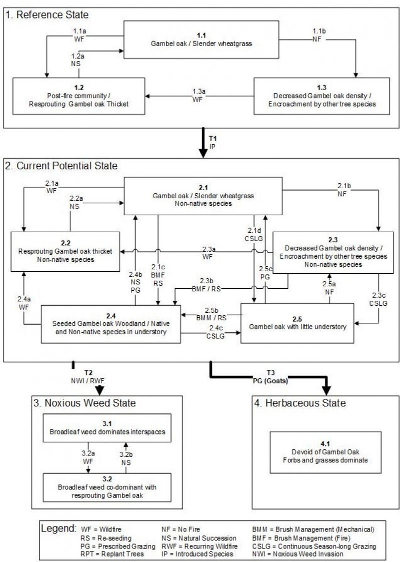
Reference State (State 1)
The reference state for the mountain loam (oak) site was determined by study of relic areas that have been protected from altered disturbance regimes and are considered to be representative of the historic climax plant community. Literature reviews, trends in plant community dynamics, and historical accounts are also considered.
State 1, the reference state, represents the historic plant communities of the mountain loam (oak) site and the naturally occurring dynamics associated with those communities. This state includes all known biotic communities that would exist under natural disturbance regimes and current climatic conditions. The dominant overstory species is Gambel oak (Quercus gambelii) with the understory dominated by the perennial bunchgrasses slender wheatgrass (Elymus trachycaulus) and/or bluebunch wheatgrass (Elymus spicata). The plant communities in state 1 are naturally resistant to disturbance and resilient following disturbance due to favorable amounts of precipitation and the ability of Gambel oak to resprout following disturbance. Wildfire is the predominant disturbance affecting ecological processes and is the primary factor driving plant community change in this state. The common fire return interval is 35 to 100 years and plant recovery following a wildfire is rapid, often with Gambel oak resprouting within the same growing season.
Community Phase 1.1 Gambel oak / Perennial bunchgrasses
This plant community consists of mature Gambel oak trees that dominate the overstory and slender wheatgrass and/or bluebunch wheatgrass that dominate the understory. Mountain brome, Geyer sedge, as well as other cool season grasses may be present. Common shrubs and forbs are mountain snowberry, Saskatoon serviceberry, thickleaf peavine, and a suite of other species adapted to grow either in the interspaces or under the canopy of Gambel oak stands. Bare ground is not common and no non-native plants are present.
Community Pathway 1.1a Wildfire --This pathway often occurs late in the growing season when precipitation is low and fuel load is at its peak. Gambel oak is at peak underground carbohydrate storage around this time of year, which provides the energy needed for resprouting.
Community Pathway 1.1b No Fire --This pathway is a subsequent step in natural succession that occurs when fire free periods approach their upper limits and allow fire sensitive species to encroach into Gambel oak sites.
Community Phase 1.2 Post-fire community / Resprouting gambel oak thicket
This plant community consists of young Gambel oak shoots that are beginning to reestablish following a wildfire. Burned trunks will usually be visible above the new growth. The gambel oak suckers often form dense thickets of foliage up to several feet in height which effectively intercept sunlight and crowd out potential invaders. Given adequate recovery time of a few months to a year, the interspaces will exhibit native buchgrasses and forbs, but few shrubs.
Community Pathway 1.2a Natural Succession—As the post-fire community ages, Gambel oak becomes less dominant near the soil surface, but maintains its dominance in the canopy. Perennial grasses become more robust and the plant community becomes more diverse with the establishment of shrubs and shade sensitive species.
Community Phase 1.3 Encroachment by Other Tree Species
This plant community is comparable in composition to community 1.1 with the addition of fire sensitive tree species such as Rocky mountain Douglas fir, Canyon maple, and white fir. The percent composition of these tree species is relatively low (3 to 5 percent).
Community Pathway 1.3a Wildfire-- This pathway often occurs late in the growing season when precipitation is low and fuel load is at its peak. Gambel oak also is at peak carbohydrate storage around this time of year, an adaptation which provides the energy needed to resprout and maintain its niche.
Transition 1-- Invasive Plants
Transition from Reference State (State 1) to current Potential State (State 2)
This transition occurs when non-native or invasive species become established in the plant community. Common invasive species include dalmatian toadflax, annual forbs, dandelion, houndstongue, rubber rabbitbrush, broom snakeweed, and cheatgrass. Intermediate wheatgrass, smooth brome, and Kentucky bluegrass may also spread into the site. Events that may facilitate the establishment of non-native plants are wildfire, introduction of livestock, seeding, and recreation.
Current Potential State (State 2)
State 2 is very similar to State 1 in form and function, with the exception of the presence of non-native plants and animals, possible extinctions of native species, and a different climate. State 2 is a description of the ecological site shortly following Euro-American settlement.
Community Phase 2.1 Gambel oak / Slender wheatgrass
Phase 2.1 is 10 to 20 percent grasses, 0 to 15 percent forbs and 80 to 90 percent shrubs by air-dry weight. After a fire, Gambel oak sprouts vigorously and suppresses perennial grass and forb production. Non-native species are present, but not dominant.
Community Pathway 2.1a Wildfire -- This pathway often occurs late in the growing season when precipitation is low and fuel load is at its peak. Gambel oak is at peak underground carbohydrate storage around this time of year, which provides the energy needed for resprouting.
Community Pathway 2.1b No Fire -- This pathway is a subsequent step in natural succession that occurs when fire free periods approach their upper limits and allow fire sensitive species to encroach into Gambel oak sites.
Community Pathway 2.1c Prescribed Fire and Re-seed – This pathway occurs when land owners and/or land managers are attempting to improve the vigor of the native plant community.
Community Pathway 2.1d Continuous Heavy Grazing – This pathway occurs when improper grazing continues for extended periods of time not allowing for native plants to recover, ultimately lowering the health and vigor of these plants to compete with available resources.
Community Phase 2.2 Resprouting Gambel oak thicket
Phase 2.2 is 20 to 40 percent grasses, 10 to 25 percent forbs, and 50 to 70 percent shrubs. Gambel oak stem density is less than phase 1.1, though oak production may be higher. Non-native species are present, but not dominant.
Community Pathway 2.2a Natural Succession on the site
Community Phase 2.3 Encroachment by other tree species
Phase 2.3 is characterized by encroachment of conifer species including Douglas fir, juniper and pinyon. Higher elevations of this ecological site are more susceptible to conifer encroachment. At lower elevations, this phase is characterized by decadent Gambel oak with patches of young sprouts. Gambel oak dies naturally around 80 years of age and promptly responds with vigorous young sprouts to replace the oak foliage. Native species are present, but not dominant
Community Pathway 2.3a Wildfire -- This pathway often occurs late in the growing season when precipitation is low and fuel load is at its peak. Gambel oak is at peak underground carbohydrate storage around this time of year, which provides the energy needed for resprouting.
Community Pathway 2.3b Brush Management (Fire) and re-seeding – Utilization of techniques such as prescribed fire and range seeding can reduce composition of invading conifers as well as temporarily reduce competition from oak to allow for the herbaceous component to become established.
Community Pathway 2.3c Continuous Heavy Grazing -- This pathway occurs when improper grazing continues for extended periods of time not allowing for native herbaceous plants and shrubs to recover, ultimately lowering the health and vigor of these plants to compete with available resources.
Community Phase 2.4 Seeded Gambel oak Woodland
Phase 2.4 is an aerial seeding following fire. Both native and non-native perennial grasses and forbs are included in most seed mixes. Under proper grazing, native grass and forb species can outcompete introduced species and dominate the understory within 5-10 years.
Community Pathway 2.4a Wildfire -- This pathway often occurs late in the growing season when precipitation is low and fuel load is at its peak. Gambel oak is at peak underground carbohydrate storage around this time of year, which provides the energy needed for resprouting.
Community Pathway 2.4b Natural Succession/prescribed grazing – This pathway can occur through natural succession and prescribed grazing. Over time the oak will begin to be the dominant aspect on the site, and with proper grazing management the herbaceous understory and shrubs will maintain health and vigor on the site.
Community Pathway 2.4c Continuous Heavy Grazing -- This pathway occurs when improper grazing continues for extended periods of time not allowing for native herbaceous plants and shrubs to recover, ultimately lowering the health and vigor of these plants to compete with available resources.
Community Phase 2.5 Overgrazed Gambel oak
Phase 2.5 displays a reduction in the herbaceous understory and shrub component do to improper grazing/browsing from livestock and wildlife.
Community Pathway 2.5a No Fire – lack of fire over time will allow other tree species to naturally encroach into the site.
Community Pathway 2.5b Brush Management (Mechanical) and re-seeding -- utilization of techniques such as mechanical brush management and range seeding can reduce composition of oak to allow for the herbaceous component to become established.
Community Pathway 2.5c Natural succession and prescribed grazing – practicing prescribed grazing over time will allow the herbaceous and shrub components to become established on this site.
Transition 2 Noxious Weed Invasion / Repeated Wildfires
Transition from State 2 to State 3
Transition 3 Prescribed Grazing (Goats)
Transition from State 2 to State 4
State 3 Noxious Weed State
State 3 is characterized by a dominance of non-native noxious weeds. The threshold has been crossed into State 3 and the dynamics of this site will likely prohibit the return back into State 2 without and extraordinary amount of external inputs.
Community Phase 3.1 Broadleaf weed dominates interspaces
Native herbaceous and shrub species have largely been replaced by prolific noxious weeds establishment which generally flourish in sites where there is a short fire return interval. This process makes it incredibly hard for native herbaceous species to become reestablished on the site. Gambel oak is able to remain on this site by utilizing available resources due to its extensive root system and its sprouting abilities following wildfire.
Community Pathway 3.1a Wildfire – The nature of this site with the abundance of noxious weeds/fine fuels shortens the fire return interval compared to the historic fire regime.
Community Phase 3.2 Weed co-dominant with resprouting Gambel oak
Following a wildfire, the herbaceous weed component and sprouting Gambel oak will dominate this site.
Community Pathway 3.2a Natural Succession – Due to the nature of this site, there is often a frequent fire return interval which will return this site back to Community Phase 3.1.
State 4: Herbaceous State:
Utilizing browsing animals such as goats, the threshold from State 2 is crossed in to this State. Browsing animals will shift the competitive advantage to the herbaceous component leaving the site devoid of Gambel oak and dominated by the herbaceous understory.
Community Phase 4.1 Devoid of Gambel oak
Community 1.1
Reference State
The general view of this site is Gambel oak. The composition by air-dry weight is approximately 40 percent perennial grasses, 10 percent forbs, and 50 percent shrubs.
Table 5. Annual production by plant type
| Plant type |
Low
(lb/acre) |
Representative value
(lb/acre) |
High
(lb/acre) |
| Shrub/Vine |
475 |
575 |
625 |
| Grass/Grasslike |
380 |
460 |
500 |
| Forb |
98 |
115 |
125 |
| Total |
953 |
1150 |
1250 |
Table 6. Ground cover
| Tree foliar cover |
0%
|
| Shrub/vine/liana foliar cover |
39-41%
|
| Grass/grasslike foliar cover |
24-26%
|
| Forb foliar cover |
9-11%
|
| Non-vascular plants |
0%
|
| Biological crusts |
0%
|
| Litter |
0%
|
| Surface fragments >0.25" and <=3" |
0%
|
| Surface fragments >3" |
0%
|
| Bedrock |
0%
|
| Water |
0%
|
| Bare ground |
0%
|
Table 7. Canopy structure (% cover)
| Height Above Ground (ft) |
Tree |
Shrub/Vine |
Grass/
Grasslike |
Forb |
| <0.5 |
– |
– |
– |
– |
| >0.5 <= 1 |
– |
– |
– |
9-11% |
| >1 <= 2 |
– |
– |
24-26% |
– |
| >2 <= 4.5 |
– |
– |
– |
– |
| >4.5 <= 13 |
– |
39-41% |
– |
– |
| >13 <= 40 |
– |
– |
– |
– |
| >40 <= 80 |
– |
– |
– |
– |
| >80 <= 120 |
– |
– |
– |
– |
| >120 |
– |
– |
– |
– |