Ecological dynamics
As vegetation communities respond to changes in management or natural occurrences, thresholds can be crossed, which usually means that a reversal of direction is probably not possible without major energy input. The amount of energy input needed to effect vegetative shifts depends on what the present vegetation is and the desired results.
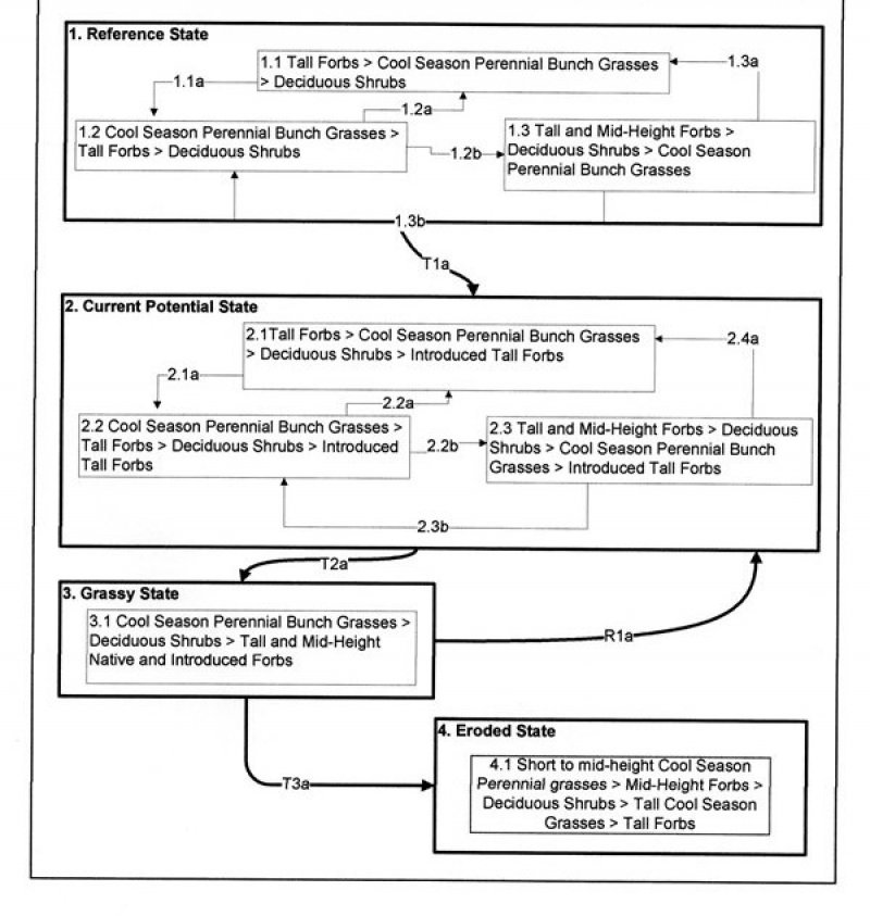
The following diagram does not necessarily depict all the transition and states that this site may exhibit, but it does show some of the most common plant communities that can occur on the site and the transition pathways (arrows) among the communities. Bold lines surrounding each plant community or communities represent ecological thresholds. The ecological processes are discussed in detail, including photos, in the Plant Community Narrative section.
State 1: Reference State
This state includes the plant communities that were best adapted to the unique combination of factors associated with this ecological site prior to European settlement. It was in a natural dynamic equilibrium with the historic biotic, abiotic, climatic factors on its ecological site in North America at the time of European immigration and settlement. This dominant aspect of the plant community is tall forbs and mountain brome. The community is made up of 25 percent grass 65 percent forbs and 10 percent shrubs on a dry weight base.
This site is impacted by rodents (i.e.) potgut squirrels and pocket gophers. Another major influencing factor in this site is fire because of its association with quaking aspen and the needed fire frequency of 80 to 100 years for the aspen communities to maintain themselves.
All of these scenarios are very interrelated and dependent on weather patterns and events as well as fire frequency and intensity and also the amount and intensity of large and small herbivore use. Any set of events that are strong enough to force the plant community out of this pattern can push it over a threshold and push it into another state.
Community Phase 1.1: Tall forb, Cool season perennial grasses, Deciduous shrubs
This is the community that is described in the initial plant list. The fact that you will not find any species of sagebrush on the site and more tall forbs than grasses during the summer months are key identifying characteristics for this site. This community is represented with a typical plant community of 25 percent grasses, 70 percent forbs and 5 percent shrubs. One of the dominant forbs visually and in production is tall bluebell. The dominant grass is mountain brome and the dominant shrub visually is mountain snowberry. This community will have around 10 to 15 percent bare ground and surface rock fragments. This site will remain in phase 1.1 so long as the site continues to have the normal 80 to 100 year fires that are associated with the surrounding quaking aspen sites and there are no prolonged disturbances.
Community Phase 1.2: Cool season perennial bunch grasses, Tall forbs, Deciduous shrubs
Cool season perennial grasses, tall forbs, and some deciduous shrubs make up this phase in the reference state. This phase shows the results of overuse by large herbivores and small ungulates when the tall forbs have been damaged and grasses are allowed to gain a stronger place in the community. This community is represented with a plant community of 40% grasses, 35% tall forbs, 15 percent mid-height forbs and 10 percent deciduous shrubs. This community will have around 15 to 20 percent bare ground and surface rock fragments.
Community Phase 1.3: Tall and mid-height forbs, Deciduous shrubs, Cool season perennial bunch grasses
Site has been overused by grazing to the point that the mid-height forbs and deciduous shrubs have the advantage on the site. This community is represented with a plant community of 20 percent grasses, 35% tall forbs, 20 percent mid-height forbs and 25% deciduous shrubs. This community will have around 15 to 25 percent bare ground and surface rock fragments.
Community Pathways:
1.1a = This is caused by overuse by ungulates (i.e.) deer and/or elk. Most likely it would be elk as deer usually do not collect in that big of herds.
1.2a = Reduced use by ungulates.
1.2b = This is caused by the continued overuse by ungulates (i.e.) Deer and/or Elk.
1.3a = This is the result of fire. After the fire the area receives enough rest time for the tall forbs to recover.
1.3b = This is the results of fire. The deference between 1.3a and 1.3b is that the area is utilized by ungulates to soon and the grasses get more opportunity to express themselves.
Transition T1a
Introduction of non-native species into the ecosystem.
State 2: Current Potential State
This state includes the biotic communities that would become established on the ecological site if all successional sequences were completed without human interference under the present environmental conditions. Natural disturbances are inherent in its development. The Current Potential State (CPS) state will include acclimatized, naturalized or invasive nonnative species. There is no known way to effectively remove these plants from the site once they have become established. The level of occurrence of these plants in the CPS is such that careful management can prevent their domination of the site. There is no restoration pathway back to the Reference State. Plant communities within the CPS state may be managed and used for various purposes without significant alteration in plant community composition or production. It includes all of the plant communities that exist in the reference state with the inclusion of species that are non-native.
All of these scenarios are very interrelated and dependent on weather patterns and events as well as fire frequency and intensity and also the amount and intensity of large and small herbivore use. Any set of events that are strong enough to force the plant community out of this pattern can push it over a threshold and push it into another state.
Community Phase 2.1: Tall forbs, Cool season perennial bunch grasses, Deciduous shrubs, Introduced tall forbs
Tall forbs, perennial cool season grasses and deciduous shrubs with mountain snowberry being the most common. The fact that you will not find any species of sagebrush on the site and more tall forbs than grasses during the summer months are key identifying characteristics for this site. This community is represented with a plant community of 25 percent grasses, 70 percent forbs and 5 percent shrubs. One of the dominant forbs visually and in production is tall bluebell. The dominant grass is mountain brome and the dominant shrub visually is mountain snowberry along with any introduced and invasive plant species. This community will have 10 to 15 percent bare ground and surface rock fragments.
Community Phase 2.2: Cool season perennial bunch grasses, Tall forbs, Deciduous shrubs, Introduced tall forbs
Cool season perennial grasses, tall forbs, and some deciduous shrubs make up this phase. This phase shows the results of overuse by large herbivores and small ungulates when the tall forbs have been damaged and grasses are allowed to gain a stronger place in the community. This community is represented with a plant community of 40 percent grasses, 35 percent tall forbs, 15 percent mid-height forbs and 10 percent deciduous shrubs along with any introduced and/or invasive plant species. This community will have 15 to 20 percent bare ground and surface rock fragments.
Community Phase 2.3: Tall and mid-height forbs, Deciduous shrubs, Cool season perennial bunch grass, Introduced tall fobs
Site has been overused by grazing to the point that the mid-height forbs and deciduous shrubs have the advantage on the site. This community is represented with a mean plant community of 20 percent grasses, 35 percent tall forbs, 20 percent mid-height forbs and 25 percent deciduous shrubs along with any introduced and/or invasive plant species. This community will have 15 to 25 percent bare ground and surface rock fragments.
Community Pathways:
2.1a = This is caused by overuse by ungulates (i.e.) deer, elk, cattle and sheep. Most likely it would be elk, cattle and/or sheep as deer usually do not collect in that big of herds.
2.2a = This is caused by overuse by ungulates (i.e.) deer, elk, cattle and sheep. Most likely it would be elk, cattle and/or sheep as deer usually do not collect in that big of herds.
2.2b = This is caused by the continued overuse by ungulates (i.e.) deer and elk.
2.3a = This is the results of fire. After the fire the area receives enough rest time for the Tall Forbs to recover.
2.3b = This is the results of fire. The difference between 2.3a and 2.3b is that the area is utilized by ungulates to soon and the grasses get a little greater opportunity to express themselves.
Transition T2a
Lack of fire disturbance and the overuse of the site by large ungulates. Prolonged drought, overgrazing, extreme lengthening of the fire interval frequency. Also prolonged drought along with prolonged overgrazing.
State 3: Grass State
This state is the condition of the site when grazing and other factors damage the forb plant community. It will have a visual and production dominance of grasses, followed by deciduous shrubs and then by those native tall and mid-height forbs and introduced forbs. The community will be 40 percent grasses, 35 percent deciduous shrubs, and 25 percent forbs. At this time forbs like Western coneflower move to the forefront in the forb community. It appears that this community can exist for an extended period of time until environmental conditions set the stage to move back to the more stable state found in the ”Current Potential State”.
Community Phase 3.1: Cool-season perennial bunchgrass, Deciduous shrubs, Tall and mid-stature native and introduced forbs
This is the state that this site will move to when it is overgrazed.
Transition T3a
Prolonged overgrazing; coupled with drought extreme lengthening of the fire interval due to the overgrazing reducing or eliminating the community’s ability to carry fire leading to extreme accelerated erosion.
Restoration Pathway R1a
Time with proper management that favors the native plants as they increase on site and/or move back into the site.
State 4: Eroded State
This is the state that exists when the site has deteriorated to the point where so much of the top soil has eroded away the site can no longer produce the plant community and support the production that it had in the “Reference or Current Potential States” It will often be represented with 15 percent mid-stature grasses, 25 percent short grasses, 35 percent deciduous shrubs, 15 percent mid-stature forbs and 10% tall forbs with the forbs being the grazing tolerant ones. At this state there will be twice as much bare ground and rock fragment visible as in the more productive states.
Community Phase 4.1: Short- and mid-stature forbs and Cool-season grasses, Deciduous shrub, Tall cool-season grass,
Short to mid-stature cool-season perennial grasses mid-height to short forbs deciduous shrubs perennial invasive plants annual invasive plants tall cool season perennial grasses tall forbs. This state exists when the site has deteriorated to the point that a good share of the top soil has eroded away and the top horizons have been lost. Return to a previous state is not possible within management time frames. Often the site will have a gravelly surface that will resemble the windblown desert soil surface known as desert pavement. In this state the site is only about one-third to one-half as productive as in the Reference State.