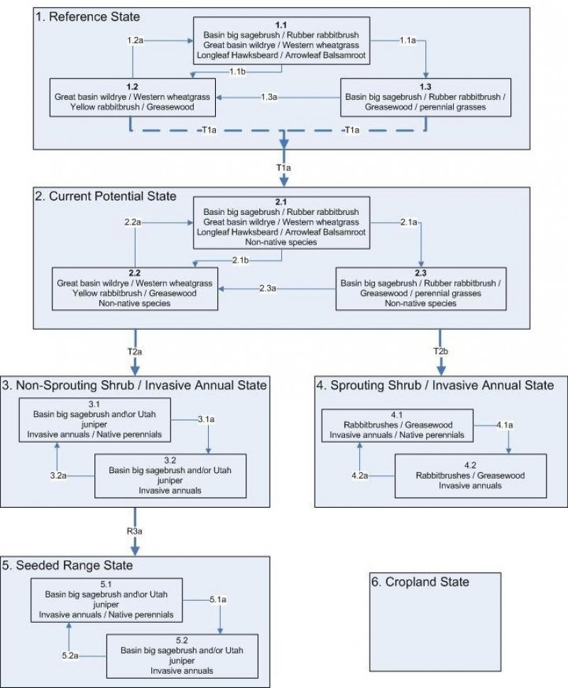

Natural Resources
Conservation Service
Ecological site R047XB016UT
Interzonal Loamy Bottom (basin wildrye)
Last updated: 2/06/2025
Accessed: 04/11/2025
General information
Provisional. A provisional ecological site description has undergone quality control and quality assurance review. It contains a working state and transition model and enough information to identify the ecological site.
MLRA notes
Major Land Resource Area (MLRA): 047X–Wasatch and Uinta Mountains
MLRA 47 occurs in Utah (86 percent), Wyoming (8 percent), Colorado (4 percent), and Idaho (2 percent). It encompasses approximately 23,825 square miles (61,740 square kilometers). The northern half of this area is in the Middle Rocky Mountains Province of the Rocky Mountain System. The southern half is in the High Plateaus of the Utah Section of the Colorado Plateaus Province of the Intermontane Plateaus. Parts of the western edge of this MLRA are in the Great Basin Section of the Basin and Range Province of the Intermontane Plateaus. The MLRA includes the Wasatch Mountains, which trend north and south, and the Uinta Mountains, which trend east and west. The steeply sloping, precipitous Wasatch Mountains have narrow crests and deep valleys. Active faulting and erosion are a dominant force in controlling the geomorphology of the area. The Uinta Mountains have a broad, gently arching, elongated shape. Structurally, they consist of a broadly folded anticline that has an erosion-resistant quartzite core. The Wasatch and Uinta Mountains have an elevation of 4,900 to about 13,500 feet (1,495 to 4,115 meters).
The mountains in this area are primarily fault blocks that have been tilted up. Alluvial fans at the base of the mountains are recharge zones for the basin fill aquifers. An ancient shoreline of historic Bonneville Lake is evident on the footslopes along the western edge of the area. Rocks exposed in the mountains are mostly Mesozoic and Paleozoic sediments, but Precambrian rocks are exposed in the Uinta Mountains. The Uinta Mountains are one of the few ranges in the United States that are oriented west to east. The southern Wasatch Mountains consist of Tertiary volcanic rocks occurring as extrusive lava and intrusive crystalline rocks.
The average precipitation is from 8 to 16 inches (203 to 406 mm) in the valleys and can range up to 73 inches (1854 mm) in the mountains. In the northern and western portions of the MLRA, peak precipitation occurs in the winter months. The southern and eastern portions have a greater incidence of high-intensity summer thunderstorms; hence, a significant amount of precipitation occurs during the summer months. The average annual temperature is 30 to 50 degrees Fahrenheit (-1 to 15 C). The freeze-free period averages 140 days and ranges from 60 to 220 days, generally decreasing in length with elevation.
The dominant soil orders in this MLRA are Aridisols, Entisols, Inceptisols, and Mollisols. The lower elevations are dominated by a frigid temperature regime, while the higher elevations experience cryic temperature regimes. Mesic temperature regimes come in on the lower elevations and south facing slopes in the southern portion of this MLRA. The soil moisture regime is typically xeric in the northern part of the MLRA, but grades to ustic in the extreme eastern and southern parts. The mineralogy is generally mixed and the soils are very shallow to very deep, generally well drained, and loamy or loamy-skeletal.
LRU notes
E47B is the Wasatch Mountains South MLRA. It occurs in the Loa, Panguitch, New Harmony area. Most of Zion, Bryce Canyon National Parks and Cedar Breaks National Monument are in this area. This area is composed of mountain ranges that run north and south.
Ecological site concept
Characteristic soils of this site are very deep and well drained. The soil moisture and temperature regimes are ustic and frigid respectively. The dry surface color is typically dark brown, but may vary with accumulative soils.
The soils of this site are usually Cumulic Haplustolls or Ustifluvents. They have been deposited in drainageways and bottoms through runoff from adjoining landforms. Therefore there maybe a great diversity in soil texture from sandy to clayey. There usually is an increase in organic matter. The water holding capacity may vary as well but the water supplying capacity of the site is usually very good because of the additional moisture delivered to the soils through runoff.
The soils are slightly saline and slightly to moderately alkaline, available water capacity is 5.8 to 7.4 inches.
Associated sites
R047XB308UT |
Upland Loam (mountain big sagebrush/Indian ricegrass) This site is on the terraces and benches above the Loamy Bottom. |
---|---|
R047XB430UT |
Mountain Loam (mountain big sagebrush) This site is on the terraces and benches above the Loamy Bottom. |
Similar sites
R047XA016UT |
Loamy Bottom (basin wildrye) |
---|
Table 1. Dominant plant species
Tree |
Not specified |
---|---|
Shrub |
(1) Artemisia tridentata ssp. vaseyana |
Herbaceous |
(1) Leymus cinereus |
Physiographic features
This site is typically located in drainageways, bottoms and valley floors. It receives run in moisture from adjoining sites during snowmelt and during high intense thunderstorms. It also can receive additional snow cover blown in off of adjoining ridges, hills and mountains. Slopes are 0 to 8 percent and runoff is medium to high depending on the surface soil texture and slope.

Figure 1. Physiographic image
Table 2. Representative physiographic features
Landforms |
(1)
Drainageway
(2) Valley floor (3) Stream terrace |
---|---|
Runoff class | Medium to high |
Flooding duration | Very brief (4 to 48 hours) to brief (2 to 7 days) |
Flooding frequency | None to rare |
Ponding frequency | None |
Elevation | 6,800 – 9,700 ft |
Slope | 8% |
Aspect | Aspect is not a significant factor |
Climatic features
Climate is characterized by cool summers and cold winters. The annual precipitation on this site occurs with about 50 percent arriving during the growing season. The wettest months are August through March. The driest are May and June. The average snow depth in the winter is between 12 and 24 inches. Summer thunderstorms are typical in July and August. Mean annual temperature is 45 degrees.
Table 3. Representative climatic features
Frost-free period (average) | 120 days |
---|---|
Freeze-free period (average) | 153 days |
Precipitation total (average) | 22 in |
Figure 2. Monthly precipitation range
Figure 3. Monthly average minimum and maximum temperature
Influencing water features
The water features of this site may include intermittent stream beds these may be deeply cut through the site carrying much of the excess snowmelt and runoff away.
This site provides an excellent opportunity for the construction of ponds or debris basins.
Wetland description
Further review is required.
Soil features
Characteristic soils of this site are very deep and well drained. The soil moisture and temperature regimes are ustic and frigid respectively. The dry surface color is typically dark brown, but may vary with accumulative soils.
The soils of this site are usually Cumulic Haplustolls or Ustifluvents. They have been deposited in drainageways and bottoms through runoff from adjoining landforms. Therefore there maybe a great diversity in soil texture from sandy to clayey. There usually is an increase in organic matter. The water holding capacity may vary as well but the water supplying capacity of the site is usually very good because of the additional moisture delivered to the soils through runoff.
The soils are slightly saline and slightly to moderately alkaline, available water capacity is 5.8 to 7.4 inches.
This site has been used in the following soil surveys and has been correlated to the following components:
UT636 - Panguitch Area - Alldown, Mitch, Neto, Plite
UT646 - Dixie Nat'l Forest - Alldown, Mitch, Neto, Plite
UT629 - Loa-Marysvale - Suelo, Runin, Shupert, Jodero
UT642 - Kane County - Sheepcan family.
Typical Soil Profile (Suelo)
A1 - 0 to 11 in.; gravelly loam
A2 - 11 to 17 in.; gravelly clay
A3 - 17 to 30 in.; gravelly clay
C - 30 to 59 in.; gravelly clay
Table 4. Representative soil features
Parent material |
(1)
Alluvium
–
andesite
(2) Slope alluvium – dacite (3) Alluvium – basalt (4) Slope alluvium – tuff |
---|---|
Surface texture |
(1) Loam (2) Gravelly loam |
Family particle size |
(1) Fine-loamy |
Drainage class | Well drained |
Permeability class | Slow to moderate |
Depth to restrictive layer | 60 in |
Soil depth | 60 in |
Surface fragment cover <=3" | 5 – 15% |
Available water capacity (0-40in) |
5.8 – 7.4 in |
Calcium carbonate equivalent (0-40in) |
5% |
Electrical conductivity (0-40in) |
2 mmhos/cm |
Sodium adsorption ratio (0-40in) |
4 |
Soil reaction (1:1 water) (0-40in) |
6.6 – 8.4 |
Subsurface fragment volume <=3" (0-40in) |
8 – 12% |
Subsurface fragment volume >3" (0-40in) |
1 – 3% |
Ecological dynamics
This ecological site was developed under Major Land Resource Area (MLRA) 47B - The Wasatch Mountains, South climatic conditions and included the natural influences of herbivory, fire, climate and rare flooding. This site occurs on very deep soils of diverse texture due to deposition from adjoining soils. The plant composition is generally dominated by grasses but several of the plant community phases are dominated by mountain big sagebrush, basin big sagebrush or rubber rabbitbrush.
This plant community if affected by run-in moisture from sites on the above watersheds. This increased moisture not only improves plant production but determines the vegetation diversity along with the annual precipitation.
Site disturbance from rate flooding events may cause the decrease of grasses, forbs and mountain big sagebrush or basin big sagebrush and the increase of rubber rabbitbrush.
Ecological Dynamics of the Site
Historic vegetation on this site was dominated by tall (7 ft) cool-season grasses, which are adapted to occasional high water tables. Other significant vegetation includes a variety of forbs and shrubs.
The dominant aspect of this site was grasses. The composition and production will vary naturally due to location (north to south of the MLRA), fluctuating precipitation, and fire return interval.
Due to the abundant forage, thermal cover, and often close proximity to water sources, this site has a high probability of receiving grazing pressures from domestic and wildlife grazers as well as having received historical grazing pressure.
Great basin wildrye is sensitive to spring grazing and clipping and frequent herbage removal during the growing season (Perry and Chapman 1976). Thus, under repetitive harvesting, Great basin wildrye can be “grazed out” of the system. As ecological condition deteriorates due to improper grazing, cool season grasses Great basin wildrye and Nevada bluegrass decrease in frequency and production. The ungrazed plants or grazing tolerant plants such as Basin big sagebrush, rabbitbrush and other will increase in frequency and production. This increase combined with the declining perennial grasses can lead to a site dominated by sagebrush and rabbitbrush with little to no understory. The area without an understory of perennial grasses and forbs has little value as a functioning ecosystem.
As a result of the grass dominated system, this site had lots of root mass and vegetation production which creates and maintains an organic layer and a mollic epipedon. If the perennial grasses are removed from the system, it is typical to see a decrease in organic matter and accelerated erosion.
Great Basin wildrye is also susceptible to black grass bugs. Black grass bugs populations will invade a site, and can destroy most of the living grasses.
The fire regime for this site is similar to the surrounding sagebrush lands. The intensity of a fire determines the vegetation succession and structure. Low intensity or ground fires typically result in the removal of litter and decadent grasses while maintaining the nominal shrub cover, while higher intensity fires will remove the shrub species. After normal to high intensity fires, basin big sagebrush decreases while rubber rabbitbrush increases. If the fire regime is suppressed, this site may be invaded by junipers.
Because of the position on the landscape, this site is typically one of the first to be invaded. Junipers will start to creep down into the sagebrush lands by using this site as a corridor. The fire transition stages are relatively short lived and tend to be mosaic in nature.
If halogeton, russian thistle, cheatgrass or other strongly invasive species invade the site concurrent to the area being stressed though disturbances or drought they are likely to invade and dominate this site.
When more information is available, this section will include a discussion of seral stages; fire influence and effects; effects of prolonged wet or dry periods; resistance to change; the influence of such things as grazing, rodent concentrations, insects, diseases, introduced species, and soil erosion or deposition; other stable vegetative states associated with this site as a result of extreme disturbance.
Community 1.1
Plant Community A
This community is dominated by Great basin wildrye. Basin big sagebrush is the major shrub. Other significant herbaceous species in the plant community include western wheatgrass, Nevada bluegrass, longleaf hawksbeard and arrowleaf balsamroot. Rubber rabbitbrush and black greasewood are other important shrubs. Percent composition by air-dry weight is 70 percent grass, 10 percent forbs, and 20 percent shrubs. Natural fire frequency is estimated to be 40 to 50 years.
Community 1.2
Plant Community B
Basin big sagebrush decreases in the community; rubber rabbitbrush also decreases, but to a lesser degree. Yellow rabbitbrush, black greasewood and, at times, horsebrush species resprout and increase in the community; much of the excess fine fuel accumulation is removed. basin wildrye and other cool season bunchgrasses recover following fire and flourish, western wheatgrass increases. Fire tolerant shrubs may persist as dominants in the shrub community for 30 years or longer.
Community 1.3
Plant Community C
Basin big sagebrush, rubber rabbitbrush, and black greasewood increase in percent composition. Shrubs show signs of decadence due to age. Great basin wildrye and other cool season bunchgrasses begin loosing vigor due to increased shrub competition and increase in old vegetation. Percent composition by air-dry weight is 40 percent grass, 10 percent forbs, and 50 percent shrubs.
Pathway 1.1b
Community 1.1 to 1.2
Disturbance: Recent fire occurrence (1 to 30 years).
Pathway 1.1a
Community 1.1 to 1.3
Extended period of time without a major disturbance such as fire; insect infestation (i.e. black grass bugs); or prolonged drought. Fire frequency extends well beyond the 40 to 50 year average for the site.
Pathway 1.2a
Community 1.2 to 1.1
40 to 50 years or more without a fire occurrence (normal fire frequency).
Pathway 1.3a
Community 1.3 to 1.2
Disturbance: Recent fire occurrence (1 to 30 years).
State 2
Current Potential State
Plant communities in this state can include native, acclimatized, naturalized and invasive non-native species. This state is irreversibly changed from the reference state because these non native species will now remain a permanent part of the community.
Community 2.1
Plant Community A
This community is dominated by Great Basin wildrye. Basin big sagebrush is the major shrub. Other significant herbaceous species in the plant community include western wheatgrass, Nevada bluegrass, longleaf hawksbeard, and arrowleaf balsamroot. Rubber rabbitbrush and black greasewood are other important shrubs. This community is dominated by native species, but may include acclimatized, naturalized and invasive non-native species. Percent composition by air-dry weight is 70 percent grass, 10 percent forbs, and 20 percent shrubs.
Community 2.2
Plant Community B
Basin big sagebrush decreases in the community; rubber rabbitbrush also decreases, but to a lesser degree. Yellow rabbitbrush, black greasewood and, at times, horsebrush species resprout and increase in the community; much of the excess fine fuel accumulation is removed. Basin wildrye and other cool season bunchgrasses recover following fire and flourish, western wheatgrass increases. Fire tolerant shrubs may persist as dominants in the shrub community for 30 years or longer. This community is dominated by native species, but may include acclimatized, naturalized and invasive non-native species.
Community 2.3
Plant Community C
Basin big sagebrush, rubber rabbitbrush and black greasewood increase in percent composition. Shrubs show signs of decadence due to age. Great Basin wildrye and other cool season bunchgrasses begin loosing vigor due to increased shrub competition and increase in old vegetation. Percent composition by air-dry weight is 40 percent grass, 10 percent forbs, and 50 percent shrubs. This community is dominated by native species, but may include acclimatized, naturalized and invasive non-native species.
Pathway 2.1b
Community 2.1 to 2.2
Recent fire occurrence (1 to 30 years).
Pathway 2.1a
Community 2.1 to 2.3
Extended period of time without a major disturbance such as fire; insect infestation (i.e. black grass bugs); or prolonged drought. Fire frequency extends well beyond the 40 to 50 year average for the site.
Pathway 2.2a
Community 2.2 to 2.1
40 to 50 years or more without a fire occurrence (normal fire frequency).
Pathway 2.3a
Community 2.3 to 2.2
Recent fire occurrence (1 to 30 years).
State 3
Utah Juniper, Brush with Annual Weeds State
Community 3.1
Plant Community A
Where Utah juniper has invaded,basin big sagebrush, rubber rabbitbrush and black greasewood may decrease,otherwise they dominate the community; Yellow rabbitbrush often increases. Remaining perennial herbaceous vegetation is mostly found only in protected locations under shrubs.Invasive,non-native grasses and weeds, including cheatgrass, annual mustards, redstem storksbill, etc. dominate the understory.
Community 3.2
Plant Community B
Where Utah juniper has invaded, basin big sagebrush, rubber rabbitbrush, and black greasewood decrease, otherwise they may dominate the community; yellow rabbitbrush often increases. Remaining perennial herbaceous vegetation is rare and is found only in protected locations under shrubs. Invasive, non-native grasses and weeds, including cheatgrass, annual mustards, redstem storksbill, etc.,dominate the understory.
Pathway 3.1a
Community 3.1 to 3.2
Disturbance: Long-term improper grazing (including, season long, overstocking, wrong season, etc.) and/or drought reduce perennial grasses. Fine fuels are reduced lessening the potential for fire to occur. Fire frequency is greater than 100 years.
Pathway 3.2a
Community 3.2 to 3.1
Site is properly grazed over an extended period of time. Native perennial vegetation slowly recovers; annual weeds dominate the understory. Fire frequency remains well beyond normal for the site. Fire frequency is greater than 100 years.
State 4
Sprouting Shrub with Annual Weeds State
Community 4.1
Plant Community A
Yellow rabbitbrush, black greasewood and smooth horsebrush resprout and dominate the shrub layer. Rubber rabbitbrush can be plentiful if conditions are right.
Fire tolerant shrubs may persist as dominants with fire periods of 10 to 30 years.
Broom snakeweed may be an episodic dominant species when conditions are favorable. Native bunchgrasses are significantly reduced; invasive annuals including cheatgrass, annual mustards, redstem storksbill, etc.dominate the understory.
Community 4.2
Plant Community B
Yellow rabbitbrush, black greasewood, and smooth horsebrush dominate the overstory community. Rubber rabbitbrush can be plentiful if conditions are right.
Fire tolerant shrubs may persist as dominants in this community with fire periods of 10 to 30 years. Broom snakeweed may be an episodic dominant species when conditions are favorable. Only remnant native bunchgrasses remain; invasive annuals including cheatgrass, annual mustards,redstem storksbill, etc. dominate the understory.
Pathway 4.1a
Community 4.1 to 4.2
Disturbance: Long-term, improper grazing (including, season long, overstocking, wrong season, etc.) and/or drought reduce perennial grasses. Highly combustible fine fuels from invasive annuals dominate the community resulting in a shortened fire frequency. Fire frequency is typically 10 to 30 years.
Pathway 4.2a
Community 4.2 to 4.1
Site is properly grazed for an extended period of time. Perennial vegetation very slowly recovers. Fire frequency is typically 10 to 30 years.
State 5
Seeded Rangeland State
Community 5.1
Plant Community A
Rangeland seeding that may be composed of introduced, native or combination grass and forb species. Unwanted trees and shrubs are reduced but may occupy a portion of the site because of natural regeneration. Invasive annual grasses and weedy forb species, primarily cheatgrass and various annual mustards, may be present in the seeding. Seeding, when healthy, is resistant to fire.
Community 5.2
Plant Community B
This state is present after either a failed seeding or an improperly grazed one. Site may be herbaceous or may be returning to trees and/or shrubs.
The state is primarily composed of invasive annual grasses and weedy forb species. Broom snakeweed may be an episodic dominant species in this community when conditions are favorable.
Pathway 5.1a
Community 5.1 to 5.2
Disturbance: Long-term improper grazing (including, season long, overstocking, wrong season, etc.) and drought reduce perennial grasses. Fine fuels are reduced lessening the potential for fire to occur. Fire frequency is greater than 100 years.
Pathway 5.2a
Community 5.2 to 5.1
Site is properly grazed over an extended period of time. Native perennial vegetation slowly recovers; annual weeds dominate the understory. Fire frequency remains well beyond normal for the site. Fire frequency is greater than 100 years.
State 6
Cropland Conversion State
Community 6.1
Plant Community A
This state occurs when the Loamy Bottom Ecological Site is altered and permanently replaced with agricultural crops such as alfalfa and grain.
This State is identified here to recognize that a very large portion of this ecological site has been converted to a cropland land use.
Transition T1a
State 1 to 2
Improper grazing (i.e. season long, overstocking, wrong season, etc.) and drought remove fine fuels from the site lessening the potential for fire to occur. This allows both sprouting and non-sprouting shrubs such as basin big sagebrush, rubber rabbitbrush and black greasewood to increase in the community. Shrubs may become decadent due to age. Great Basin wildrye and other native bunchgrasses lose vigor and decrease in the community due to shrub competition and grazing pressure; western wheatgrass may increase. Utah juniper seedlings and saplings may begin to invade the community if a seed source is available.
The threshold is crossed when there is an introduction of non native species, primarily cheatgrass and various annual mustards, that become established on the site.
Prior to crossing the threshold, if this site is properly grazed over an extended period of time native perennial vegetation may recover. Fire frequency can return to within the normal range for the site. These events could set the site back into the normal range of variability.
Transition T2a
State 2 to 3
Long-term improper grazing (including, season long, overstocking, wrong season, etc.); and/or prolonged drought; lengthened fire return interval resulting in a dense non-sprouting tree and/or shrub overstory, reduction of native perennial understory vegetation and increasing invading annuals. Utah junipers may increase to occupy a significant portion of the overstory, if a seed source is present. Basin big sagebrush dominates the shrub layer and may be decadent due to age. Rubber rabbitbrush and greasewood may also be present. Great Basin wildrye and other native bunchgrasses are significantly reduced due to increased shrub competition and heavy grazing pressure; western wheatgrass may increase. The threshold is crossed when invasive annuals including cheatgrass, annual mustards, redstem storksbill, etc. dominate the understory. The occurrence of fire extends well beyond the normal period for the site.
Transition T2b
State 2 to 4
Disturbance: Sustained, long-term improper grazing (including, season long, overstocking, wrong season, etc.) and/or prolonged drought; shortened fire frequency allows site to be dominated by sprouting shrubs including yellow rabbitbrush, black greasewood and smooth horsebrush; significant reduction of perennial bunchgrass species. There is an invasion of annual grasses and weedy forb species primarily cheatgrass and various annual mustards.
Restoration pathway R3a
State 3 to 5
Disturbance: Mechanical chaining of Utah juniper where present, and mechanical or chemical treatment of unwanted brush species; with seeding of introduced, native or combination rangeland species.
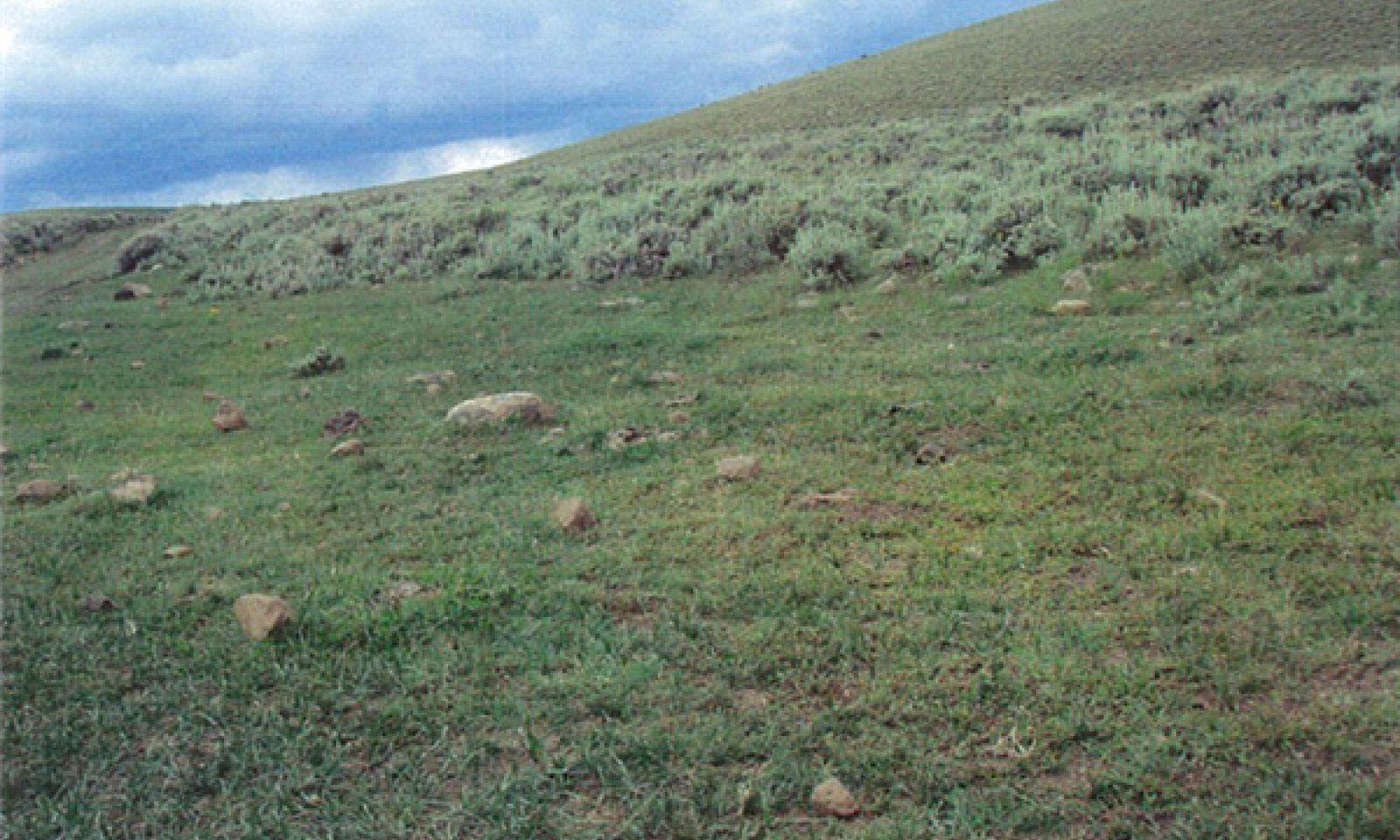
State and transition model

More interactive model formats are also available.
View Interactive Models
More interactive model formats are also available.
View Interactive Models
Click on state and transition labels to scroll to the respective text
Ecosystem states
State 1 submodel, plant communities
State 1
Reference State
Community 1.1
Basin Wildrye/ Mountain Big Sagebrush

Figure 4. Community Phase 1.2
This community phase represents the expected plant community for this ecological site in a near reference state. There is not much data available to prove or disprove this plant compostion or production. Most of the information comes from the Pangutich Area Soil Survey. This community is characterized by basin wildrye, westen wheatgrass and sandberg bluegrass, along with a shrub canopy of mountain big sagebrush or basin big sagebrush and some rubber rabbitbrush. The air-dry weight is approximately 65 percent grasses, 10 percent forbs and 25 percent shrubs.
Figure 5. Annual production by plant type (representative values) or group (midpoint values)
Table 5. Annual production by plant type
Plant type | Low (lb/acre) |
Representative value (lb/acre) |
High (lb/acre) |
---|---|---|---|
Grass/Grasslike | 650 | 975 | 1300 |
Shrub/Vine | 250 | 375 | 500 |
Forb | 100 | 150 | 200 |
Total | 1000 | 1500 | 2000 |
Additional community tables
Table 6. Community 1.1 plant community composition
Group | Common name | Symbol | Scientific name | Annual production (lb/acre) | Foliar cover (%) | |
---|---|---|---|---|---|---|
Forb
|
||||||
1 | Primary Forbs | 100–200 | ||||
pale agoseris | AGGL | Agoseris glauca | 20–40 | – | ||
lupine | LUPIN | Lupinus | 20–40 | – | ||
clover | TRIFO | Trifolium | 20–40 | – | ||
Grass/Grasslike
|
||||||
2 | Primary Grasses | 550–1100 | ||||
basin wildrye | LECI4 | Leymus cinereus | 400–800 | – | ||
western wheatgrass | PASM | Pascopyrum smithii | 100–200 | – | ||
Sandberg bluegrass | POSE | Poa secunda | 50–100 | – | ||
1 | Secondary Grasses | 100–200 | ||||
Indian ricegrass | ACHY | Achnatherum hymenoides | 20–40 | – | ||
blue grama | BOGR2 | Bouteloua gracilis | 20–40 | – | ||
Geyer's sedge | CAGE2 | Carex geyeri | 20–40 | – | ||
squirreltail | ELEL5 | Elymus elymoides | 20–40 | – | ||
Shrub/Vine
|
||||||
3 | Primary Shrubs | 200–400 | ||||
basin big sagebrush | ARTRT | Artemisia tridentata ssp. tridentata | 150–300 | – | ||
mountain big sagebrush | ARTRV | Artemisia tridentata ssp. vaseyana | 150–300 | – | ||
rubber rabbitbrush | ERNA10 | Ericameria nauseosa | 50–100 | – | ||
1 | Secondary Shrubs | 50–100 | ||||
yellow rabbitbrush | CHVI8 | Chrysothamnus viscidiflorus | 20–40 | – | ||
Woods' rose | ROWO | Rosa woodsii | 20–40 | – | ||
mountain snowberry | SYOR2 | Symphoricarpos oreophilus | 20–40 | – | ||
Tree
|
||||||
1 | Primary Tree | 10–20 | ||||
Utah juniper | JUOS | Juniperus osteosperma | 10–20 | – |
Interpretations
Animal community
Wildlife Interpretations --
This site is important to deer, elk and antelope for grazing and cover. It is also important to the blacktailed jackrabbit, a few whitetailed jackrabbit and cottontails, coyote, badger and fox. The Greater Sage Grouse use this site for feed and cover, particularly when small forbs are available for chick rearing. When the mountain big sagebrush and rubber rabbitbrush increases choking out the forbs and grasses, this site looses some of its importance to all wildlife species.
Grazing Interpretations --
This site provides excellent summer and fall grazing to all livestock due to its accessibility and forage supply. It is an excellent supplier of forbs, grass and palatable browse species. The mountain big sagebrush provides grazing to all big game and livestock in late fall when early snow arrives
Hydrological functions
The soils associated with this ecological site are generally in Hydrological Soil Group B. Runoff potential on this site is low to medium depending on soils and slopes. This site provides an excellent filter for runoff from adjoining sites, retaining the sediment and preventing it from leaving the watershed. Frequent flooding may disturb the plant community and allow rubber rabbitbrush to invade and increase on the site.
Recreational uses
Recreation activities include aesthetic value and good opportunities for hunting, hiking, horseback riding, and off road vehicle use. Due to possible high erosion potential after surface disturbance, care should be taken when planning recreational activities. Camp sites are limited but available when some shelter trees have invaded on the site.
Wood products
None
Other information
Fire Ecology --
This site usually has a fuel load to carry a fire, but much of the year the plant moisture content is high enough to limit fire. Fire was a typical disturbance in the historic climax plant community for this ecological site. Rubber rabbitbrush may increase or invade the site if burned and the mountain big sagebrush is removed.
Supporting information
Inventory data references
Information presented here has been derived from NRCS clipping data and other inventory data. Field observations from range trained personnel were also used.
Type locality
Location 1: Wayne County, UT | |
---|---|
Township/Range/Section | T29S R1E S4 |
UTM zone | N |
UTM northing | 429,270 |
UTM easting | 4221,420 |
Latitude | 38° 19′ 5″ |
Longitude | 111° 48′ 32″ |
General legal description | About 10 miles southwest of Loa, Utah near Jakees Knoll on Parker Mountain. |
Other references
Alexander, R. R. 1985. Major habitat types, community types, and plant communities in the Rocky Mountains. USDA- Forest Service Rocky Mountain Forest and Range Experiment Station. General technical report RM-123. 105p.
Alexander 1988. Forest vegetation on National Forests in the Rocky Mountain and Intermountain Regions: Habitat types and community types. USDA- Forest Service Rocky Mountain Forest and Range Experiment Station. General technical report RM-162. 47p.
Galatowitsch, S.M. 1990. Using the original land survey notes to reconstruct pre-settlement landscapes in the American West. Great Basin Naturalist: 50(2): 181-191. Keywords: [Western U.S., conservation, history, human impact]
Parson, R. E. 1996. A History of Rich County. Utah State Historical Society, County Commission, Rich County, Utah. Keywords: [Rich County, Utah, Historic land use, European settlements]
USDA-NRCS. 2003. National Range and Pasture Handbook. in USDA, editor, USDA-Natural Resources Conservation Service-Grazing Lands Technology Institute. Keywords: [Western US, Federal guidelines, Range pasture management]
Western Regional Climate Center, Western U.S. Climate Historical Summaries. Available at: http://www.wrcc.dri.edu/summary/Climsmut.html. Accessed 15 June 2009.
Web Soil Survey, Official Soil Series Descriptions. Available at: http://soils.usda.gov/technical/classification/osd/index.html. Accessed 15 June 2009.
Contributors
T. Simper
Approval
Kendra Moseley, 2/06/2025
Rangeland health reference sheet
Interpreting Indicators of Rangeland Health is a qualitative assessment protocol used to determine ecosystem condition based on benchmark characteristics described in the Reference Sheet. A suite of 17 (or more) indicators are typically considered in an assessment. The ecological site(s) representative of an assessment location must be known prior to applying the protocol and must be verified based on soils and climate. Current plant community cannot be used to identify the ecological site.
Author(s)/participant(s) | |
---|---|
Contact for lead author | |
Date | 02/06/2025 |
Approved by | Kendra Moseley |
Approval date | |
Composition (Indicators 10 and 12) based on | Annual Production |
Indicators
-
Number and extent of rills:
-
Presence of water flow patterns:
-
Number and height of erosional pedestals or terracettes:
-
Bare ground from Ecological Site Description or other studies (rock, litter, lichen, moss, plant canopy are not bare ground):
-
Number of gullies and erosion associated with gullies:
-
Extent of wind scoured, blowouts and/or depositional areas:
-
Amount of litter movement (describe size and distance expected to travel):
-
Soil surface (top few mm) resistance to erosion (stability values are averages - most sites will show a range of values):
-
Soil surface structure and SOM content (include type of structure and A-horizon color and thickness):
-
Effect of community phase composition (relative proportion of different functional groups) and spatial distribution on infiltration and runoff:
-
Presence and thickness of compaction layer (usually none; describe soil profile features which may be mistaken for compaction on this site):
-
Functional/Structural Groups (list in order of descending dominance by above-ground annual-production or live foliar cover using symbols: >>, >, = to indicate much greater than, greater than, and equal to):
Dominant:
Sub-dominant:
Other:
Additional:
-
Amount of plant mortality and decadence (include which functional groups are expected to show mortality or decadence):
-
Average percent litter cover (%) and depth ( in):
-
Expected annual annual-production (this is TOTAL above-ground annual-production, not just forage annual-production):
-
Potential invasive (including noxious) species (native and non-native). List species which BOTH characterize degraded states and have the potential to become a dominant or co-dominant species on the ecological site if their future establishment and growth is not actively controlled by management interventions. Species that become dominant for only one to several years (e.g., short-term response to drought or wildfire) are not invasive plants. Note that unlike other indicators, we are describing what is NOT expected in the reference state for the ecological site:
-
Perennial plant reproductive capability:
Print Options
Sections
Font
Other
The Ecosystem Dynamics Interpretive Tool is an information system framework developed by the USDA-ARS Jornada Experimental Range, USDA Natural Resources Conservation Service, and New Mexico State University.
Click on box and path labels to scroll to the respective text.