Natural Resources
Conservation Service
Ecological site R047XB244UT
Semidesert Silt Loam (winterfat)
Last updated: 2/06/2025
Accessed: 04/03/2026
General information
Provisional. A provisional ecological site description has undergone quality control and quality assurance review. It contains a working state and transition model and enough information to identify the ecological site.
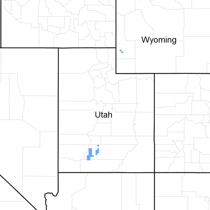
Figure 1. Mapped extent
Areas shown in blue indicate the maximum mapped extent of this ecological site. Other ecological sites likely occur within the highlighted areas. It is also possible for this ecological site to occur outside of highlighted areas if detailed soil survey has not been completed or recently updated.
MLRA notes
Major Land Resource Area (MLRA): 047X–Wasatch and Uinta Mountains
MLRA 47 occurs in Utah (86 percent), Wyoming (8 percent), Colorado (4 percent), and Idaho (2 percent). It encompasses approximately 23,825 square miles (61,740 square kilometers). The northern half of this area is in the Middle Rocky Mountains Province of the Rocky Mountain System. The southern half is in the High Plateaus of the Utah Section of the Colorado Plateaus Province of the Intermontane Plateaus. Parts of the western edge of this MLRA are in the Great Basin Section of the Basin and Range Province of the Intermontane Plateaus. The MLRA includes the Wasatch Mountains, which trend north and south, and the Uinta Mountains, which trend east and west. The steeply sloping, precipitous Wasatch Mountains have narrow crests and deep valleys. Active faulting and erosion are a dominant force in controlling the geomorphology of the area. The Uinta Mountains have a broad, gently arching, elongated shape. Structurally, they consist of a broadly folded anticline that has an erosion-resistant quartzite core. The Wasatch and Uinta Mountains have an elevation of 4,900 to about 13,500 feet (1,495 to 4,115 meters).
The mountains in this area are primarily fault blocks that have been tilted up. Alluvial fans at the base of the mountains are recharge zones for the basin fill aquifers. An ancient shoreline of historic Bonneville Lake is evident on the footslopes along the western edge of the area. Rocks exposed in the mountains are mostly Mesozoic and Paleozoic sediments, but Precambrian rocks are exposed in the Uinta Mountains. The Uinta Mountains are one of the few ranges in the United States that are oriented west to east. The southern Wasatch Mountains consist of Tertiary volcanic rocks occurring as extrusive lava and intrusive crystalline rocks.
The average precipitation is from 8 to 16 inches (203 to 406 mm) in the valleys and can range up to 73 inches (1854 mm) in the mountains. In the northern and western portions of the MLRA, peak precipitation occurs in the winter months. The southern and eastern portions have a greater incidence of high-intensity summer thunderstorms; hence, a significant amount of precipitation occurs during the summer months. The average annual temperature is 30 to 50 degrees Fahrenheit (-1 to 15 C). The freeze-free period averages 140 days and ranges from 60 to 220 days, generally decreasing in length with elevation.
The dominant soil orders in this MLRA are Aridisols, Entisols, Inceptisols, and Mollisols. The lower elevations are dominated by a frigid temperature regime, while the higher elevations experience cryic temperature regimes. Mesic temperature regimes come in on the lower elevations and south facing slopes in the southern portion of this MLRA. The soil moisture regime is typically xeric in the northern part of the MLRA, but grades to ustic in the extreme eastern and southern parts. The mineralogy is generally mixed and the soils are very shallow to very deep, generally well drained, and loamy or loamy-skeletal.
LRU notes
LRU 47B
E47B is the Wasatch Mountains South MLRA. It occurs in the Loa, Panguitch, New Harmony area. Most of Zion, Bryce Canyon National Parks and Cedar Breaks National Monument are in this area. This area is composed of mountain ranges that run north and south.
Classification relationships
Modal Soil: Codley Silt Loam 1 to 2% — fine-silty, carbonatic, frigid Ustic Torriorthents
Ecological site concept
The soils in this site are deep and well drained and occur on dissected alluvial fans and valley flats. They were formed in alluvium derived primarily from igneous and sedimentary rock. Slopes are linear and long. Typically, the surface layer is a strongly alkali silt loam about 7 inches thick. Underlying layers are also strongly alkaline and range from silt loam to silty clay loam. Permeability is moderate to moderately slow and available water holding capacity is 6.7 to 7.0. Effective rooting depth is 60 inches or more. Runoff is slow and water erosion hazard is slight.
Associated sites
| R047XB210UT |
Semidesert Gravelly Loam (black sagebrush) |
|---|---|
| R047XB221UT |
Semidesert Loam (black sagebrush) |
Similar sites
| R047XB220UT |
Semidesert Loam (basin big sagebrush) These sites have similar floral and soil characteristics. |
|---|
Table 1. Dominant plant species
| Tree |
Not specified |
|---|---|
| Shrub |
(1) Krascheninnikovia lanata |
| Herbaceous |
(1) Pascopyrum smithii |
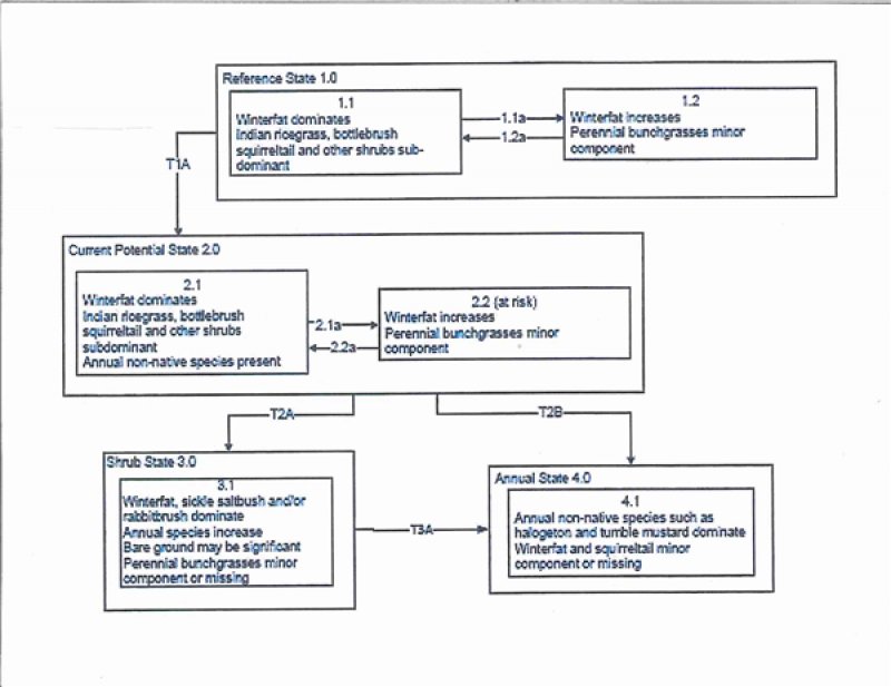
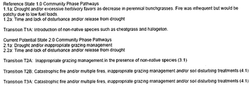
Click on box and path labels to scroll to the respective text.