Natural Resources
Conservation Service
Ecological site EX049X01X210
Sandy Foothill Palmer Divide
Last updated: 5/02/2025
Accessed: 12/20/2025
General information
Provisional. A provisional ecological site description has undergone quality control and quality assurance review. It contains a working state and transition model and enough information to identify the ecological site.
MLRA notes
Major Land Resource Area (MLRA): 049X–Southern Rocky Mountain Foothills
Major Land Resource Area (MLRA) 49, Southern Rocky Mountain Foothills, comprises approximately 11,130 square miles running north to south, from south-central Wyoming (27 percent), the length of the Front Range of Colorado (58 percent), and into north-central New Mexico (15 percent). Almost half of this area occurs in the Southern Rocky Mountains and Wyoming Basin provinces in the Rocky Mountain system. The remainder is in the Colorado Pediment, Raton, and High Plains Section of the Great Plains Province of the Interior Plains. The northern part consists of the Laramie Mountains. The central and southern parts generally are bounded on the east by the Great Plains and on the west by the Southern Rocky Mountains (USDA Ag. Handbook 296). The average elevation ranges from 5,000 to 8,000 feet. Annual precipitation ranges from 10 to 35 inches.
LRU notes
The Palmer Divide Land Resource Unit (LRU) is a transition zone between the mountains and plains and describes the central Colorado foothills of the Front Range, including the Palmer Divide. It includes the cities of Highlands Ranch, Castle Rock, and Kiowa in Douglas and Elbert counties. The Black Forest-Palmer Divide area is central, while Cheyenne Mountain State Park at Colorado Springs is the southernmost extent in El Paso County. It is characterized by Gambel oak (Quercus gambelii) and ponderosa pine (Pinus ponderosa), with ponderosa pine increasing at higher elevations. The ponderosa pine transitions into grasslands on the drier eastern fringes as it transitions into the plains. This area was historically used for ranching, limited farming, logging, mining, and quarry activities.
The area experienced an influx of people during the Colorado Gold Rush of 1859. Because of its proximity to Denver and Colorado Springs, many of the original ranches and small towns have been converted to subdivisions, small acreages, and suburbs. Some cities, such as Castle Rock, have zoned "open space" for recreation.
Ecological site concept
The Sandy Foothill site is a run-off site that receives no extra water beyond normal precipitation. It is not influenced by rock fragments in the surface horizon and has sandy surface textures. Positioned on gently sloping to rolling hills and uplands the site ranges from 5,500 to 7,000 feet in elevation and is usually on slopes that vary from nearly level to 10 percent. The soils are moderately deep to very deep. They are typically well-drained with moderate to moderately high permeability. The surface layer is most commonly sandy loam, and occasionally loamy sand.
Associated sites
| EX049X01X214 |
Gravelly Foothill Palmer Divide This site is intermixed with and often positioned higher on the landscape than the sandy site. |
|---|
Similar sites
| EX049X01X202 |
Loamy Foothill Palmer Divide This site has a fine-loamy family particle size and has surface texture of loam, silt loam or fine sandy loam and is 20 to 60 inches in depth. |
|---|---|
| EX049X01X208 |
Clayey Foothill Palmer Divide This site has a fine family particle size and has surface textures of clay loam, clay, silty clay, or silty clay loam. |
Table 1. Dominant plant species
| Tree |
Not specified |
|---|---|
| Shrub |
(1) Prunus pumila var. besseyi |
| Herbaceous |
(1) Andropogon gerardii |
Legacy ID
R049XC210CO
Physiographic features
This site is commonly found on gently sloping to rolling hills and uplands on hills, valley sides, and alluvial fan remnants. It is usually on slopes that vary from nearly level to 10 percent. Elevation ranges from 5,500 feet to 7,000 feet.
Table 2. Representative physiographic features
| Landforms |
(1)
Hills
> Hill
(2) Hills > Upland slope (3) Alluvial plain remnant > Alluvial fan (4) Hills > Valley side |
|---|---|
| Flooding duration | Extremely brief (0.1 to 4 hours) to very brief (4 to 48 hours) |
| Flooding frequency | None to very rare |
| Ponding frequency | None |
| Elevation | 5,500 – 6,820 ft |
| Slope | 10% |
| Water table depth | 60 in |
| Aspect | Aspect is not a significant factor |
Table 3. Representative physiographic features (actual ranges)
| Flooding duration | Extremely brief (0.1 to 4 hours) to very brief (4 to 48 hours) |
|---|---|
| Flooding frequency | None to very rare |
| Ponding frequency | None |
| Elevation | 5,500 – 7,000 ft |
| Slope | 22% |
| Water table depth | 60 in |
Climatic features
The average annual precipitation is 14 to 19 inches per year but can vary from 11 to 20 inches depending upon the year and location within the LRU. Approximately 60 to 75 percent of the annual precipitation occurs during the growing season from late April to late September. The Rocky Mountains to the west intercept much of the precipitation from Pacific storms during the winter. Snowfall can vary from 39 inches to 75 inches, depending upon elevation and location. Snowfall averages 63 inches annually across the LRU. Wind speeds average 10 miles per hour annually. Daytime winds are generally stronger than nighttime, and occasional strong storms may bring brief periods of high winds with gusts to more than 60 miles per hour.
The average length of the freeze-free period is 142 days but varies from 111 to 172 days in five (5) out of 10 years. The average date of first freeze (28 degrees or below) in the fall is September 22, and the average last freeze in the spring is May 17. July is the hottest month and January is the coldest. Summer temperatures are moderate, with average highs in the low 80s and occasionally reaching the mid-90s.
Summer nights are comfortably cool, with lows averaging in the 50s. Higher elevations can receive a dusting of snow in early September. Severe cold is normally of short duration. Summer humidity is low and evaporation is high.
Cool-season plants generally begin growth from April 1 to April 15. Native warm-season plants typically begin growth about May 1 to May 15. Cool-season plants generally continue to grow through the summer and fall, in comparison to the warmer and drier eastern plains where cool-season plants exhibit summer dormancy.
Table 4. Representative climatic features
| Frost-free period (characteristic range) | 104-119 days |
|---|---|
| Freeze-free period (characteristic range) | 133-139 days |
| Precipitation total (characteristic range) | 14-19 in |
| Frost-free period (actual range) | 101-125 days |
| Freeze-free period (actual range) | 131-143 days |
| Precipitation total (actual range) | 11-20 in |
| Frost-free period (average) | 112 days |
| Freeze-free period (average) | 136 days |
| Precipitation total (average) | 17 in |
Figure 1. Monthly precipitation range
Figure 2. Monthly minimum temperature range
Figure 3. Monthly maximum temperature range
Figure 4. Monthly average minimum and maximum temperature
Figure 5. Annual precipitation pattern
Figure 6. Annual average temperature pattern
Climate stations used
-
(1) CASTLE ROCK [USC00051401], Castle Rock, CO
-
(2) COLORADO SPRINGS MUNI AP [USW00093037], Colorado Springs, CO
-
(3) RUSH 1N [USC00057287], Rush, CO
-
(4) ELIZABETH 2NW [USC00052631], Elizabeth, CO
-
(5) PARKER 6 E [USC00056326], Parker, CO
Influencing water features
This site is not associated with any water features.
Wetland description
This site is not associated with wetland characteristics.
Soil features
The soils of this site are typically very deep but also include deep and moderately deep soils. They are well drained with moderate to moderately high permeability. These soils are normally formed in alluvium, eolian deposits, and sandstone residuum. They occur frequently on hills, valley sides, and alluvial fan remnants and less frequently on ridges, active alluvial fans, and stream terraces. The available water capacity is typically moderate or low. Low available water capacity is more likely on sites with moderately deep soils and/or high sand contents. The soil surface layer ranges from five to 17 inches thick and is most commonly sandy loam and occasionally loamy sand. Subsurface textures are typically loamy or sandy. Rock fragments are not high on most sites. However, fragments (dominantly in the less than 3-inch fraction) can occasionally cover as much as 25 percent of the surface and comprise up to 50 percent by volume of the subsoil.
The soil taxonomic order is predominantly mollisols with dark surfaces and high organic matter in the surface and upper subsoil. Less frequently Aridisols characterized by dryer conditions and less organic matter are found. The soil moisture regime is typically ustic (aridic subgroup) and occasionally aridic (ustic subgroup) soils. The soil temperature regime is mesic. The pH of these soils ranges from slightly acidic to moderately alkaline.
Major soil series correlated to this ecological site include:
Ascalon sandy loam, Blakeland sandy loam, Blakeland loamy sand, Blendon sandy loam, Bresser sandy loam, Nelson fine sandy loam, Tassel fine sandy loams, Stapleton sandy loam, Terry sandy loam, Truckton sandy loam, and Truckton loamy sand.
Other soil series that have been correlated to this site include:
Bijou sandy loam, Bressner loamy sand, Gove sandy loam, Kutch sandy loam, Orsa coarse sandy loam, Renohill sandy loam (reddish variant), and Paymaster sandy loam.
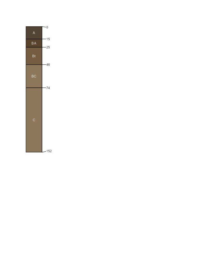
Figure 7. Bresser Series Profile.
Table 5. Representative soil features
| Parent material |
(1)
Alluvium
–
sandstone
(2) Residuum – sedimentary rock (3) Eolian deposits |
|---|---|
| Surface texture |
(1) Gravelly sandy loam (2) Loamy sand |
| Drainage class | Well drained to excessively drained |
| Permeability class | Moderate to rapid |
| Soil depth | 40 – 60 in |
| Surface fragment cover <=3" | 50% |
| Surface fragment cover >3" | 10% |
| Available water capacity (0-40in) |
3 – 8 in |
| Calcium carbonate equivalent (0-40in) |
10% |
| Electrical conductivity (0-40in) |
2 mmhos/cm |
| Sodium adsorption ratio (0-40in) |
Not specified |
| Soil reaction (1:1 water) (0-40in) |
6.1 – 8.4 |
Table 6. Representative soil features (actual values)
| Drainage class | Well drained to excessively drained |
|---|---|
| Permeability class | Moderate to rapid |
| Soil depth | 40 – 60 in |
| Surface fragment cover <=3" | 50% |
| Surface fragment cover >3" | 10% |
| Available water capacity (0-40in) |
3 – 8 in |
| Calcium carbonate equivalent (0-40in) |
10% |
| Electrical conductivity (0-40in) |
2 mmhos/cm |
| Sodium adsorption ratio (0-40in) |
Not specified |
| Soil reaction (1:1 water) (0-40in) |
6.1 – 8.4 |
Ecological dynamics
The Sandy Foothill ecological site is characterized by four states: Reference, Altered, Invaded, and Degraded states. Transitions between states and their respective communities are primarily driven by natural disturbance regimes. The most significant of these are periodic drought, grazing that results in chronic defoliation, and the natural fire regime. The timing and magnitude of these disturbances affect the various stages of the vegetative communities as described in the state-and-transition model (STM).
The historical fire frequency of the the Palmer Divide LRU ranges from 6 to 10 years (Guyette, et al 2012). The impact of fire over the past 50 years has been relatively insignificant due to wildfire suppression and the lack of acceptance of prescribed fire as a management tool. Prolonged drought and fire suppression have increased the frequency and intensity of periodic wildfires in the area.
Most of this ecological site has been fragmented due to tillage and urban development.
The state and transition model (STM) diagram for this ecological site is depicted in this section. Thorough descriptions of each state, transition, plant community, and pathway are found following model. This STM is based on available experimental research, field observations, professional consensus, and interpretations. While based on the best available information, creating the STM is a dynamic process. The document may be modified as knowledge of the specific ecological processes increases.
State and transition model
More interactive model formats are also available.
View Interactive Models
Click on state and transition labels to scroll to the respective text
Ecosystem states
| R2A | - | Prescribed Grazing. Prescribed Burning. |
|---|
State 1 submodel, plant communities
| 1.2A | - | Prescribed Grazing. Prescribed Burning. |
|---|---|---|
| 1.3A | - | Prescribed Grazing. Prescribed Burning. |
State 2 submodel, plant communities
State 3 submodel, plant communities
State 4 submodel, plant communities
State 1
Reference
The Reference state of the Sandy Foothill Palmer Divide ecological site is characterized by three distinct plant communities. These communities represent the natural range of variability and fluctuate within the parameters that define the state. Precipitation patterns and management strategies regarding herbivory and fire frequency are the primary drivers that determine the distribution of these communities throughout this state (Anderson et al, 1982).
Characteristics and indicators. This state has not been sod-busted or overly eroded and has slight to moderate vegetative deviation from the historical mixed-grass prairie community.
Resilience management. The Reference state can be maintained by managing herbivory with appropriate stocking rates, and the timing and duration of grazing periods. Maintaining a natural fire regime with appropriately timed prescribed burning also contributes to this resilience.
Dominant plant species
-
western sandcherry (Prunus pumila var. besseyi), shrub
-
spreading buckwheat (Eriogonum effusum), shrub
-
big bluestem (Andropogon gerardii), grass
-
prairie sandreed (Calamovilfa longifolia), grass
-
switchgrass (Panicum virgatum), grass
-
Indiangrass (Sorghastrum nutans), grass
-
purple prairie clover (Dalea purpurea), other herbaceous
-
scarlet globemallow (Sphaeralcea coccinea), other herbaceous
Community 1.1
Big Bluestem, Prairie Sandreed, and Switchgrass
The potential vegetation for the Big Bluestem, Prairie Sandreed, and Switchgrass community is about 70 to 85 percent grasses and grass-like plants, 10 to 15 percent forbs, and five to 15 percent woody plants. The major grasses include big bluestem (Andropogon gerardii), prairie sandreed (Calamovilfa longifolia), switchgrass (Panicum virgatum), and Indiangrass (Sorghastrum nutans). Needle and thread (Hesperostipa comata) and western wheatgrass (Pascopyrum smithii) are major cool-season mid-grasses in this plant community and are valuable forage plants in late spring and early summer. Sub-dominant grasses include blue grama (Bouteloua gracilis), little bluestem (Schizachryium scoparium), sideoats grama, (Bouteloua curtipendula), and sand dropseed (Sporobolus cryptandrus). Major forbs are purple prairieclover, upright prairie coneflower (Ratibida columnifera), scarlet globemallow, and dotted gayfeather (Liatris punctata). A minor amount of shrubs such as western sandcherry, spreading buckwheat, and soapweed yucca (Yucca glauca) may also occur. This plant community is diverse, stable, and productive. Litter is uniformly distributed with very little movement off site, and natural plant mortality is very low. It is well suited to carbon sequestration, water infiltration, wildlife use by many species, livestock use, and is aesthetically pleasing. Community dynamics, nutrient cycle, water cycle, and energy flow are functioning properly. This community is resistant to many disturbances with the exceptions of excessive herbivory, tillage, and development. Total annual production averages 1,900 pounds pounds of air-dry vegetation per acre and ranges from 1,000 to 2,700.
Resilience management. This community can be maintained by managing herbivory with appropriate stocking rates and timing and duration of grazing periods. Maintaining a natural fire regime with appropriately timed prescribed burning also contributes to resilience.
Dominant plant species
-
western sandcherry (Prunus pumila var. besseyi), shrub
-
spreading buckwheat (Eriogonum effusum), shrub
-
big bluestem (Andropogon gerardii), grass
-
prairie sandreed (Calamovilfa longifolia), grass
-
switchgrass (Panicum virgatum), grass
-
Indiangrass (Sorghastrum nutans), grass
-
purple prairie clover (Dalea purpurea), other herbaceous
-
upright prairie coneflower (Ratibida columnifera), other herbaceous
-
scarlet globemallow (Sphaeralcea coccinea), other herbaceous
Figure 8. Annual production by plant type (representative values) or group (midpoint values)
Table 7. Annual production by plant type
| Plant type | Low (lb/acre) |
Representative value (lb/acre) |
High (lb/acre) |
|---|---|---|---|
| Grass/Grasslike | 775 | 1475 | 2100 |
| Forb | 125 | 235 | 330 |
| Shrub/Vine | 100 | 190 | 270 |
| Total | 1000 | 1900 | 2700 |
Table 8. Ground cover
| Tree foliar cover | 0-1% |
|---|---|
| Shrub/vine/liana foliar cover | 3-10% |
| Grass/grasslike foliar cover | 50-80% |
| Forb foliar cover | 1-15% |
| Non-vascular plants | 0-1% |
| Biological crusts | 0-1% |
| Litter | 0-15% |
| Surface fragments >0.25" and <=3" | 0-1% |
| Surface fragments >3" | 0-1% |
| Bedrock | 0% |
| Water | 0% |
| Bare ground | 0-10% |
Table 9. Soil surface cover
| Tree basal cover | 0-1% |
|---|---|
| Shrub/vine/liana basal cover | 0-5% |
| Grass/grasslike basal cover | 7-15% |
| Forb basal cover | 0-5% |
| Non-vascular plants | 0-1% |
| Biological crusts | 0-1% |
| Litter | 0% |
| Surface fragments >0.25" and <=3" | 0-5% |
| Surface fragments >3" | 0-1% |
| Bedrock | 0% |
| Water | 0% |
| Bare ground | 50-90% |
Figure 9. Plant community growth curve (percent production by month). CO4902, Warm season tallgrass dominant; MLRA 49C; upland sandy soils.
| Jan | Feb | Mar | Apr | May | Jun | Jul | Aug | Sep | Oct | Nov | Dec |
|---|---|---|---|---|---|---|---|---|---|---|---|
| J | F | M | A | M | J | J | A | S | O | N | D |
| 5 | 15 | 35 | 25 | 15 | 5 |
Community 1.2
Decadent Big Bluestem, Switchgrass, and Prairie Sandreed
This plant community occurs when grazing is removed for long periods of time in the absence of fire. Plant composition is similar to the 1.1 community but plant vigor and individual species production arereduced. White sagebrush (Artemisia ludoviciana) and prairie sagebrush (Artemisia frigida) increase. The semiarid environment and the absence of animal impact to break down litter slows nutrient recycling. Excessive litter also limits sunlight from reaching plant crowns, reducing seed germination and seedling establishment. In advanced stages, plant mortality increases and erosion occurs as bare ground increases.
Resilience management. To sustain this community, occasional light disturbance from herbivory or prescribed fire is recommended.
Dominant plant species
-
western sandcherry (Prunus pumila var. besseyi), shrub
-
spreading buckwheat (Eriogonum effusum), shrub
-
big bluestem (Andropogon gerardii), grass
-
prairie sandreed (Calamovilfa longifolia), grass
-
switchgrass (Panicum virgatum), grass
-
purple prairie clover (Dalea purpurea), other herbaceous
-
upright prairie coneflower (Ratibida columnifera), other herbaceous
Figure 10. Plant community growth curve (percent production by month). CO4904, Warm season tallgrass excess litter; MLRA 49C; upland sandy soils.
| Jan | Feb | Mar | Apr | May | Jun | Jul | Aug | Sep | Oct | Nov | Dec |
|---|---|---|---|---|---|---|---|---|---|---|---|
| J | F | M | A | M | J | J | A | S | O | N | D |
| 15 | 30 | 25 | 20 | 10 |
Community 1.3
Blue Grama, Prairie Sandreed, Switchgrass, and Big Bluestem
Blue grama has increased with a corresponding decrease in the relative amount of warm-season tallgrasses such as big bluestem, prairie sandreed, and switchgrass. Sand dropseed, hairy false goldenaster (Heterotheca villosa), Cuman ragweed (Ambrosia psilostachya), white locoweed (Oxytropis sericea), and Drummond's milkvetch (Astragalus drummindii) have also increased. Spring grazing and summer deferment reduces the cool-season component (needle and thread and western wheatgrass), of this plant community and increases the warm-season component. Spring deferment and summer grazing increases the cool-season component and decreases the warm-season component (big bluestem, prairie sandreed, switchgrass) of this plant community. This plant community is relatively stable but at risk of losing some of the tallgrass species, palatable forbs, and shrubs. The reduction of tallgrass species, nitrogen-fixing forbs, key shrubs, and the increase of warm-season short-grasses has altered the biotic integrity of this plant community. The nutrient cycle, water cycle, and energy flow are at risk of becoming impaired.
Resilience management. Seasonal, moderate herbivory and maintenance of the historic fire regime sustains this plant community.
Dominant plant species
-
spreading buckwheat (Eriogonum effusum), shrub
-
western sandcherry (Prunus pumila var. besseyi), shrub
-
blue grama (Bouteloua gracilis), grass
-
prairie sandreed (Calamovilfa longifolia), grass
-
switchgrass (Panicum virgatum), grass
-
big bluestem (Andropogon gerardii), grass
-
Cuman ragweed (Ambrosia psilostachya), other herbaceous
-
hairy false goldenaster (Heterotheca villosa), other herbaceous
Figure 11. Plant community growth curve (percent production by month). CO4903, Warm season shortgrass dominant; MLRA 49C; upland sandy soils.
| Jan | Feb | Mar | Apr | May | Jun | Jul | Aug | Sep | Oct | Nov | Dec |
|---|---|---|---|---|---|---|---|---|---|---|---|
| J | F | M | A | M | J | J | A | S | O | N | D |
| 10 | 40 | 25 | 20 | 5 |
Pathway 1.1A
Community 1.1 to 1.2
Lack of disturbances such as herbivory, mowing, and periodic fire moves this plant community to the Decadent Big Bluestem, Switchgrass, and Prairie Sandreed community. This community is characterized by excessive litter, low plant density, and increased plant mortality.
Context dependence. The amount of growing season precipitation affects the rate and degree of this community shift.
Pathway 1.1B
Community 1.1 to 1.3
Excessive herbivory without adequate recovery periods between grazing events, and interruption of the historical fire regime shift this community to the Blue Grama, Prairie Sandreed, Switchgrass, and Big Bluestem community.
Context dependence. The amount of growing season precipitation affects the rate and magnitude of this transition.
Pathway 1.2A
Community 1.2 to 1.1
Prescribed grazing with adequate recovery periods and proper stocking rate restore this plant community to the Big Bluestem, Prairie Sandreed, and Switchgrass community. Prescribed burning accelerates this process.
Context dependence. Abundant growing season precipitation accelerates this process, while drought hampers recovery.
Conservation practices
| Prescribed Burning | |
|---|---|
| Prescribed Grazing |
Pathway 1.2B
Community 1.2 to 1.3
Excessive long-term herbivory causes this community to transition to the 1.3 community.
Context dependence. Local precipitation patterns affect the rate and magnitude of this shift.
Pathway 1.3A
Community 1.3 to 1.1
Herbivory with adequate recovery periods restores this community to the 1.1 community. Appropriately timed prescribed burning accelerates this transition.
Context dependence. Adequate seasonal precipitation accelerates this process while drought hampers the restoration.
Conservation practices
| Prescribed Burning | |
|---|---|
| Prescribed Grazing |
State 2
Altered
The Altered state is characterized by the Blue Grama plant community. An ecological threshold has been crossed relative to the Reference state resulting in loss of resilience. This state is relatively resistant to disturbances due to this sod forming growth form of blue grama.
Characteristics and indicators. This state has a lack of diversity due to the dominance of blue grama and a corresponding reduction in the amount of warm-season tallgrasses. The structure of the plant community has changed from tallgrasses to shortgrass.
Resilience management. Light to moderate herbivory maintains this state.
Dominant plant species
-
spreading buckwheat (Eriogonum effusum), shrub
-
soapweed yucca (Yucca glauca), shrub
-
blue grama (Bouteloua gracilis), grass
-
sand dropseed (Sporobolus cryptandrus), grass
-
scarlet globemallow (Sphaeralcea coccinea), other herbaceous
-
Cuman ragweed (Ambrosia psilostachya), other herbaceous
Community 2.1
Blue Grama
Big bluestem, prairie sandreed, switchgrass, Indiangrass, needle and thread, and western wheatgrass have all significantly decreased. Blue grama dominates the plant community. Sand dropseed, along with forbs and shrubs such as hairy goldaster, Cuman ragweed, prairie sagewort, small soapweed (Yucca glauca) , and plains pricklypear (Opuntia polyacantha), have increased. This plant community remains stable but has lost significant production and biologic diversity. Nutrient and hydrologic cycles and energy flow are impaired. Desertification is advanced.
Resilience management. Light to moderate herbivory maintains this community.
Dominant plant species
-
prairie sagewort (Artemisia frigida), shrub
-
soapweed yucca (Yucca glauca), shrub
-
plains pricklypear (Opuntia polyacantha), shrub
-
blue grama (Bouteloua gracilis), grass
-
sand dropseed (Sporobolus cryptandrus), grass
-
hairy false goldenaster (Heterotheca villosa), other herbaceous
-
Cuman ragweed (Ambrosia psilostachya), other herbaceous
Figure 12. Plant community growth curve (percent production by month). CO4903, Warm season shortgrass dominant; MLRA 49C; upland sandy soils.
| Jan | Feb | Mar | Apr | May | Jun | Jul | Aug | Sep | Oct | Nov | Dec |
|---|---|---|---|---|---|---|---|---|---|---|---|
| J | F | M | A | M | J | J | A | S | O | N | D |
| 10 | 40 | 25 | 20 | 5 |
State 3
Degraded
The Blue Grama, Sleepygrass, Yucca, and Broom Snakeweed community characterizes this state. A further ecological threshold has been crossed as shown by a loss of resilience and resistance to disturbance.
Characteristics and indicators. An increase in the amount of bare ground is readily distinguishable. Plant community structure appears as patchy areas of blue grama and sleepygrass (Achnatherum robustum) with scattered shrubs such as soapweed yucca (Yucca glauca), broom snakeweed (Gutierrezia sarothrae), and plains pricklypear.
Resilience management. Light herbivory maintains this state.
Dominant plant species
-
broom snakeweed (Gutierrezia sarothrae), shrub
-
soapweed yucca (Yucca glauca), shrub
-
blue grama (Bouteloua gracilis), grass
-
sleepygrass (Achnatherum robustum), grass
-
hairy false goldenaster (Heterotheca villosa), other herbaceous
-
prairie sagewort (Artemisia frigida), other herbaceous
Community 3.1
Blue Grama, Sleepygrass, Yucca, and Broom Snakeweed
During the first stages of regression, less palatable forbs and shrubs like hairy goldaster, fringed sagebrush, and yucca increase. Under continued heavy grazing, sleepygrass and six weeks fescue replace blue grama . The amount of bare ground increases. This plant community phase is unstable. Desertification is well advanced and wind and water erosion are concerns.
Resilience management. This community is unstable, but light herbivory may maintain it's current condition.
Dominant plant species
-
soapweed yucca (Yucca glauca), shrub
-
broom snakeweed (Gutierrezia sarothrae), shrub
-
sleepygrass (Achnatherum robustum), grass
-
sixweeks fescue (Vulpia octoflora), grass
Dominant resource concerns
-
Sheet and rill erosion
-
Wind erosion
-
Ephemeral gully erosion
-
Classic gully erosion
Figure 13. Plant community growth curve (percent production by month). CO4923, Snakeweed, Pioneer Annual/Perennials, Bare Ground; MLRA 49. Warm/cool season, annual/perennial forbs.
| Jan | Feb | Mar | Apr | May | Jun | Jul | Aug | Sep | Oct | Nov | Dec |
|---|---|---|---|---|---|---|---|---|---|---|---|
| J | F | M | A | M | J | J | A | S | O | N | D |
| 5 | 10 | 20 | 25 | 30 | 10 |
State 4
Invaded
The Invaded state is characterized by the Cheatgrass, Russian Thistle, and Broom Snakeweed community. An ecological threshold has been crossed as shown by a significant degradation of biologic integrity, and impaired hydrologic function.
Characteristics and indicators. The distinguishing characteristic is the dominance of invasive species.
Resilience management. This state is unstable.
Dominant plant species
-
broom snakeweed (Gutierrezia sarothrae), shrub
-
plains pricklypear (Opuntia polyacantha), shrub
-
cheatgrass (Bromus tectorum), grass
-
knapweed (Centaurea), other herbaceous
-
Russian thistle (Salsola), other herbaceous
-
Canada thistle (Cirsium arvense), other herbaceous
Community 4.1
Cheatgrass, Russian Thistle, and Broom Snakeweed
The community is dominated by invasive species. Production varies greatly depending on the plant density and weather conditions in any year.
Resilience management. This condition is not stable and desertification is well advanced. Wind and water erosion are concerns.
Dominant plant species
-
plains pricklypear (Opuntia polyacantha), shrub
-
soapweed yucca (Yucca glauca), shrub
-
sleepygrass (Achnatherum robustum), grass
-
cheatgrass (Bromus tectorum), grass
-
knapweed (Centaurea), other herbaceous
-
Russian thistle (Salsola), other herbaceous
-
Canada thistle (Cirsium arvense), other herbaceous
Dominant resource concerns
-
Sheet and rill erosion
-
Wind erosion
-
Ephemeral gully erosion
-
Classic gully erosion
Transition T1A
State 1 to 2
Excessive herbivory without adequate recovery periods and disruption of the natural fire regime.
Constraints to recovery. Impaired hydrologic function, reduced nutrient cycle, and altered energy flow due to the shallow root-pan that developed under the sod-bound blue grama.
Context dependence. Drought accelerates this transition.
Transition T1B
State 1 to 4
Excessive herbivory without adequate recovery periods and disruption of the natural fire regime. Tillage or disturbance and fragmentation associated with residential construction also causes this transition.
Constraints to recovery. Interruption of the hydrologic cycle and the complete loss of the historical structural functional groups make recovery to the Reference state highly unlikely.
Context dependence. Local precipitation patterns greatly influence the response of the vegetative community.
Restoration pathway R2A
State 2 to 1
Prescribed grazing management that allows adequate recovery and proper stocking facilitate recovery to the Reference state. Appropriately timed prescribed burning accelerates this process.
Context dependence. Local precipitation patterns influence the rate of recovery.
Conservation practices
| Prescribed Burning | |
|---|---|
| Prescribed Grazing |
Transition T2A
State 2 to 3
Excessive herbivory without adequate recovery periods causes this transition. Interruption of the natural fire regime accelerates this process.
Constraints to recovery. Loss of a natural revegetation source, presence of a compaction layer in the soil due to lack of deep-rooted native grasses, reduced water infiltration, and increased surface runoff are all constraints to recovery once this threshold has been crossed.
Context dependence. Local precipitation patterns influence the development of the vegetative community.
Additional community tables
Table 10. Community 1.1 plant community composition
| Group | Common name | Symbol | Scientific name | Annual production (lb/acre) | Foliar cover (%) | |
|---|---|---|---|---|---|---|
|
Grass/Grasslike
|
||||||
| 1 | Grass and Grasslike Plants | 775–2100 | ||||
| big bluestem | ANGE | Andropogon gerardii | 285–475 | 20–35 | ||
| prairie sandreed | CALO | Calamovilfa longifolia | 190–285 | 15–25 | ||
| switchgrass | PAVI2 | Panicum virgatum | 190–285 | 15–25 | ||
| Indiangrass | SONU2 | Sorghastrum nutans | 60–190 | 5–15 | ||
| blue grama | BOGR2 | Bouteloua gracilis | 35–135 | 5–15 | ||
| sideoats grama | BOCU | Bouteloua curtipendula | 20–95 | 1–10 | ||
| needle and thread | HECO26 | Hesperostipa comata | 35–95 | 3–10 | ||
| western wheatgrass | PASM | Pascopyrum smithii | 20–95 | 1–10 | ||
| little bluestem | SCSC | Schizachyrium scoparium | 35–95 | 3–10 | ||
| mountain muhly | MUMO | Muhlenbergia montana | 20–95 | 1–10 | ||
| sand dropseed | SPCR | Sporobolus cryptandrus | 20–35 | 1–5 | ||
| thickspike wheatgrass | ELLA3 | Elymus lanceolatus | 20–35 | 1–5 | ||
| hairy grama | BOHI2 | Bouteloua hirsuta | 20–35 | 1–5 | ||
| Indian ricegrass | ACHY | Achnatherum hymenoides | 20–35 | 1–5 | ||
| prairie Junegrass | KOMA | Koeleria macrantha | 20–35 | 1–5 | ||
| Geyer's sedge | CAGE2 | Carex geyeri | 20–35 | 1–5 | ||
| threadleaf sedge | CAFI | Carex filifolia | 0–20 | 0–1 | ||
| squirreltail | ELEL5 | Elymus elymoides | 0–20 | 0–1 | ||
|
Forb
|
||||||
| 2 | Forbs | 125–330 | ||||
| purple prairie clover | DAPU5 | Dalea purpurea | 60–95 | 5–20 | ||
| scarlet globemallow | SPCO | Sphaeralcea coccinea | 0–20 | 0–1 | ||
| upright prairie coneflower | RACO3 | Ratibida columnifera | 0–20 | 0–1 | ||
| Drummond's milkvetch | ASDR3 | Astragalus drummondii | 0–20 | 0–1 | ||
| Cuman ragweed | AMPS | Ambrosia psilostachya | 0–20 | 0–1 | ||
| lacy tansyaster | MAPIP | Machaeranthera pinnatifida ssp. pinnatifida | 0–20 | 0–1 | ||
| textile onion | ALTE | Allium textile | 0–20 | 0–1 | ||
| red dome blanketflower | GAPI | Gaillardia pinnatifida | 0–20 | 0–1 | ||
| threadleaf ragwort | SEFLF | Senecio flaccidus var. flaccidus | 0–20 | 0–1 | ||
| tarragon | ARDR4 | Artemisia dracunculus | 0–20 | 0–1 | ||
| sand lupine | LUAM | Lupinus ammophilus | 0–20 | 0–1 | ||
| white locoweed | OXSE | Oxytropis sericea | 0–20 | 0–1 | ||
| broadbeard beardtongue | PEAN4 | Penstemon angustifolius | 0–20 | 0–1 | ||
| prairie spiderwort | TROC | Tradescantia occidentalis | 0–20 | 0–1 | ||
| grassy deathcamas | ZIVEG | Zigadenus venenosus var. gramineus | 0–20 | 0–1 | ||
| twolobe larkspur | DENU2 | Delphinium nuttallianum | 0–20 | 0–1 | ||
| western wallflower | ERAS2 | Erysimum asperum | 0–20 | 0–1 | ||
| white sagebrush | ARLU | Artemisia ludoviciana | 0–20 | 0–1 | ||
| slimflower scurfpea | PSTE5 | Psoralidium tenuiflorum | 0–20 | 0–1 | ||
| hairy false goldenaster | HEVI4 | Heterotheca villosa | 0–20 | 0–1 | ||
| scarlet gilia | IPAG | Ipomopsis aggregata | 0–20 | 0–1 | ||
| common starlily | LEMO4 | Leucocrinum montanum | 0–20 | 0–1 | ||
| dotted blazing star | LIPU | Liatris punctata | 0–20 | 0–1 | ||
|
Shrub/Vine
|
||||||
| 3 | Shrubs and Half-Shrubs | 100–270 | ||||
| western sandcherry | PRPUB | Prunus pumila var. besseyi | 60–95 | 3–15 | ||
| Shrub, other | 2S | Shrub, other | 20–60 | 1–10 | ||
| spreading buckwheat | EREF | Eriogonum effusum | 20–40 | 1–5 | ||
| soapweed yucca | YUGL | Yucca glauca | 0–20 | 0–1 | ||
| plains pricklypear | OPPO | Opuntia polyacantha | 0–20 | 0–1 | ||
| prairie rose | ROAR3 | Rosa arkansana | 0–20 | 0–1 | ||
| prairie sagewort | ARFR4 | Artemisia frigida | 0–20 | 0–1 | ||
Interpretations
Animal community
GRAZING INTERPRETATIONS:
This site provides excellent spring and summer forage for cattle, horses, sheep, antelope, deer, and small mammals.
The animal forage preference changes as the growing season progresses. This coupled with the fact that this site has a good complement of cool- and warm-season plants, make it important that planned deferment and rotation be scheduled.
Cool-season plants are very nutritious during the early spring. It is therefore necessary to periodically defer grazing in the spring so that these grasses are not grazed out and replaced by less desirable species. Warm-season plants benefit by deferment from grazing during the late spring and early summer months.
Vegetative palatability influences proper use considerations. The season of use, species of grazing animal, past grazing use, and plant composition directly influence animal preference and performance.
Guide to Initial Stocking Rates:
Stocking rates given below are based on continuous use for the entire growing season and are intended only as an initial guide. However, continuous grazing is not recommended. Forage needs are calculated based on 912.5 pounds of ingested air-dry forage per animal unit month (AUM). Useable production is based on total annual production in a normal year with a harvest efficiency of 25 percent.
Plant Community (PC) Production (lbs./acre) and Suggested Initial Stocking Rate (AUM/acre)
1.1 community - (1500) (0.41)
1.3 community - (1200 ) (0.33 )
2.1 community - (800 ) (0.22 )
Adjustments to the initial stocking rates should be made as needed to obtain proper use. A field inventory must be conducted before establishing a grazing plan and assigning stocking rates.
WILDLIFE INTERPRETATIONS:
This site provides habitat for pronghorn, deer, cottontail, jackrabbit, small mammals, non-gamebirds, quail, and doves.
This site has a high value for wildlife because of the excellent habitat produced. This is due to the amount of cover and protection afforded by the taller grasses, and the abundance of forbs produced. If range condition declines from overgrazing with cattle, pronghorn, and mule deer numbers are reduced due to lack of quality forage. Other small mammals, quail, and cottontail also decline in numbers.
Hydrological functions
Soils in this site are grouped into "A" and "B" hydrologic groups. Field investigations are needed to determine hydrologic cover conditions and hydrologic curve numbers.
Recreational uses
This site has good to excellent aesthetic appeal and natural beauty due to the numerous forbs and shrubs that bloom from spring to early summer. The recreation provided through hunting, hiking, photography, bird watching, and other opportunities is of high value on this site.
Wood products
Wood products are extremely limited on this site.
Other products
This site has limited potentials for other products.
Supporting information
Inventory data references
A minimum of 20 low or medium intensity observations are required to meet verification level status. This ESD has NRI and 417 data that meet these minimums. Individual observations are listed in EDIT and are viewable behind the login. A corresponding tracking sheet is available in the MLRA office that links the list to the actual observations used in the analysis.
53 Confidential NRI-GL on-site data points collected in Arapahoe, Douglas, Elbert, El Paso, Fremont, Huerfano, and Pueblo counties in Colorado in this ESD from 2003 to 2020 were reviewed in 2024 and accepted by Doug Whisenhunt.
Five 417 field data observations from 1968 to 1970 collected in El Paso and Elbert counties were analyzed in 2024 by Doug Whisenhunt.
References
-
Anderson, R.C. 1982. An evolutionary model summarizing the roles of fire, climate, and grazing animals in the origin and maintenance of grasslands. Pages 297–308 in , , and , editors. Grasses and grasslands: systematics and ecology.
-
Cleland, D.T., J.A. Freeouf, J.E. Keys, G.J. Nowacki, C. Carpenter, and W.H. McNab. 2007. Ecological Subregions: Sections and Subsections of the Coterminous United States. USDA Forest Service, General Technical Report WO-76. Washington, DC. 1–92.
-
Fenneman, N.M. 1917. Physiographic Subdivision of the United States. Proceedings of the National Academy of Sciences 3:17–22.
-
Guyette, R.P., M.C. Stambaugh, D.C. Dey, and R. Muzika. 2012. Predicting Fire Frequency with Chemistry and Climate. Ecosystems 15:322–335.
-
United States Department of Agriculture, . 2022. Land Resource Regions and Major Land Resource Areas of the United States, the Caribbean, and the Pacific Basin.
Contributors
Ben P. Berlinger
Revised by Doug Whisenhunt
Approval
Kirt Walstad, 5/02/2025
Rangeland health reference sheet
Interpreting Indicators of Rangeland Health is a qualitative assessment protocol used to determine ecosystem condition based on benchmark characteristics described in the Reference Sheet. A suite of 17 (or more) indicators are typically considered in an assessment. The ecological site(s) representative of an assessment location must be known prior to applying the protocol and must be verified based on soils and climate. Current plant community cannot be used to identify the ecological site.
| Author(s)/participant(s) |
Ben Berlinger Daniel Nosal |
|---|---|
| Contact for lead author | Ben.Berlinger@co.usda.gov |
| Date | 11/29/2018 |
| Approved by | Kirt Walstad |
| Approval date | |
| Composition (Indicators 10 and 12) based on | Annual Production |
Indicators
-
Number and extent of rills:
None. -
Presence of water flow patterns:
Typically none, if present short and disconnected. -
Number and height of erosional pedestals or terracettes:
Pedestalled plants caused by wind erosion, if present, are few. -
Bare ground from Ecological Site Description or other studies (rock, litter, lichen, moss, plant canopy are not bare ground):
Three (3) percent or less bare ground. Bare patches range from two to four inches in diameter. Prolonged drought or fire cause bare ground to increase to three to seven percent with bare patches ranging from seven to 10 inches in diameter. -
Number of gullies and erosion associated with gullies:
None. -
Extent of wind scoured, blowouts and/or depositional areas:
None. A minor amount of wind scouring is evident on disturbed areas with minor deposition adjacent to the disturbed area. Fire or extended drought exacerbates the appearance. -
Amount of litter movement (describe size and distance expected to travel):
Litter is uniformly distributed with none to slight movement. On steep slopes or knolls, litter moves from a few inches to one foot depending on the intensity of wind and rainfall events. -
Soil surface (top few mm) resistance to erosion (stability values are averages - most sites will show a range of values):
Average Soil Stability Class rating is anticipated to be four or five in the plant interspaces at the soil surface. The soil surface is stabilized by decomposing organic matter. -
Soil surface structure and SOM content (include type of structure and A-horizon color and thickness):
Modal soils have A horizon ranges from six to 10 inches in depth. The A horizon color is typically grayish brown (10YR 5/2), with sandy loam texture. Soil surface structure is moderate fine granular. -
Effect of community phase composition (relative proportion of different functional groups) and spatial distribution on infiltration and runoff:
Cover from sod forming grasses, bunchgrasses, forbs, and shrubs reduce bare ground. Raindrop impact is reduced as well as overland flow, providing increased time for infiltration to occur. Dense stands of blue grama can limit infiltration due to high root densities. Extended drought may reduce short and mid-statured bunchgrass basal cover resulting in decreased infiltration and increased runoff following intense storms. -
Presence and thickness of compaction layer (usually none; describe soil profile features which may be mistaken for compaction on this site):
No compaction layer present. -
Functional/Structural Groups (list in order of descending dominance by above-ground annual-production or live foliar cover using symbols: >>, >, = to indicate much greater than, greater than, and equal to):
Dominant:
Warm-season tall bunchgrassSub-dominant:
Warm-season tall rhizomatous grass>warm-season mid- bunchgrass>cool season mid- bunchgrass/grasslikes>warm-season short bunchgrass >shrubs = forbsOther:
leguminous forbsAdditional:
Biological Crust: Trace (based on cover not composition by weight) -
Amount of plant mortality and decadence (include which functional groups are expected to show mortality or decadence):
Typically minimal. Expect slightly more bunchgrass mortality during and following drought. Lack of disturbance increases occurrence of decadence. -
Average percent litter cover (%) and depth ( in):
Litter cover averages 30 to 45 percent at 0.25 to 0.50 inch depth. Litter cover during and following drought ranges from 20 to 30 percent and five to 15 percent following wildfire. -
Expected annual annual-production (this is TOTAL above-ground annual-production, not just forage annual-production):
1,000 lbs./ac. during low precipitation years; 1,900 lbs./ac. during average precipitation years; 2,700 lbs./ac. during high precipitation years. After extended drought or the first growing season following wildfire, production may be significantly reduced by 200 to 500 pounds per acre or more. -
Potential invasive (including noxious) species (native and non-native). List species which BOTH characterize degraded states and have the potential to become a dominant or co-dominant species on the ecological site if their future establishment and growth is not actively controlled by management interventions. Species that become dominant for only one to several years (e.g., short-term response to drought or wildfire) are not invasive plants. Note that unlike other indicators, we are describing what is NOT expected in the reference state for the ecological site:
Invasive plants should not occur in the 1.1 plant community. Annuals may temporarily occupy the site following extended fire or drought if a seed source is available. -
Perennial plant reproductive capability:
The only limitations are weather-related, wildfire, natural disease, and insects that may temporarily reduce reproductive capability.
Print Options
Sections
Font
Other
The Ecosystem Dynamics Interpretive Tool is an information system framework developed by the USDA-ARS Jornada Experimental Range, USDA Natural Resources Conservation Service, and New Mexico State University.
Click on box and path labels to scroll to the respective text.
Ecosystem states
| R2A | - | Prescribed Grazing. Prescribed Burning. |
|---|
State 1 submodel, plant communities
| 1.2A | - | Prescribed Grazing. Prescribed Burning. |
|---|---|---|
| 1.3A | - | Prescribed Grazing. Prescribed Burning. |